

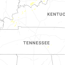
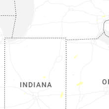
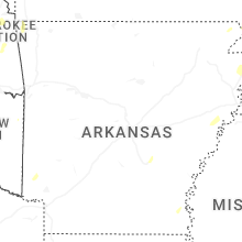
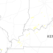
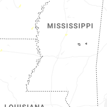
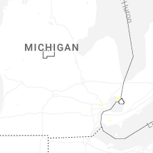
Hail Map for Tuesday, May 19, 2026

Number of Impacted Households on 5/19/2026
0
Impacted by 1" or Larger Hail
0
Impacted by 1.75" or Larger Hail
0
Impacted by 2.5" or Larger Hail
Square Miles of Populated Area Impacted on 5/19/2026
0
Impacted by 1" or Larger Hail
0
Impacted by 1.75" or Larger Hail
0
Impacted by 2.5" or Larger Hail
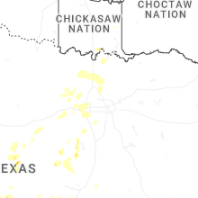


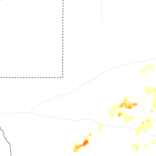
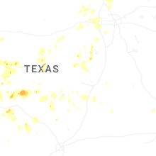
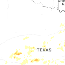
Cities Most Affected by Hail Storms of 5/19/2026
| Hail Size | Demographics of Zip Codes Affected | ||||||
|---|---|---|---|---|---|---|---|
| City | Count | Average | Largest | Pop Density | House Value | Income | Age |
| Rowena, TX | 1 | 1.75 | 1.75 | 4 | $47k | $30.7k | 43.1 |
| Laughlin A F B, TX | 1 | 1.75 | 1.75 | 3 | $0k | $0.0k | 23.3 |
Hail and Wind Damage Spotted on 5/19/2026
Filter by Report Type:Hail ReportsWind Reports
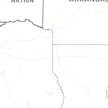
States Impacted
Missouri, Arkansas, Texas, Michigan, Virginia, Indiana, Ohio, Kentucky, Connecticut, Massachusetts, New Hampshire, West Virginia, Louisiana, New YorkMissouri
| Local Time | Report Details |
|---|---|
| 8:00 AM CDT | A few reports of trees down in mcdonald county from the storms this morning. time was estimated via radar. one report was near southwest city on state highway pp... one in mcdonald county MO, 72 miles WSW of Springfield, MO |
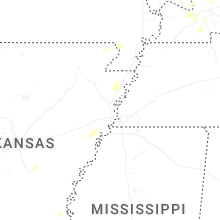
Arkansas
| Local Time | Report Details |
|---|---|
| 8:07 AM CDT | Time estimated by radar; picture of large tree limb down sent in by the public and relayed by broadcast medi in benton county AR, 56 miles N of Fort Smith, AR |
| 9:45 AM CDT | Measured wind gusts 50 to 55 mph; large tree limbs downe in crawford county AR, 20.3 miles NE of Fort Smith, AR |
| 2:40 PM CDT | Law enforcement received report of a tree falling on a house on south laurel street in hop in hempstead county AR, 24.7 miles SE of Nashville, AR |
| 3:01 PM CDT | Emergency management received report of a tree on a vehicle on county rd 139 at the intersection of county rd 2 in lafayette county AR, 43.8 miles SSE of Nashville, AR |
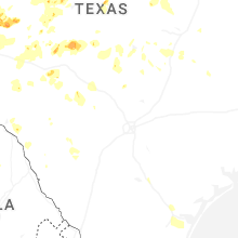
Texas
| Local Time | Report Details |
|---|---|
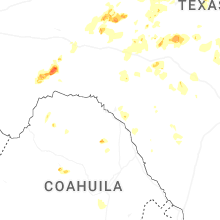
| 12:50 PM CDT | Half Dollar sized hail reported near Miles, TX, 63.9 miles SSW of Abilene, TX |
| 1:00 PM CDT | Golf Ball sized hail reported near Rowena, TX, 59.8 miles SSW of Abilene, TX |
| 3:30 PM CDT | Quarter sized hail reported near Brownwood, TX, 65.9 miles SE of Abilene, TX |
| 3:50 PM CDT | Trained spotter measured a 64 mph wind gust with a handheld anemomete in dallas county TX, 11.1 miles NNW of Dallas, TX |
| 4:20 PM CDT | Quarter sized hail reported near Barnhart, TX, 77.2 miles ESE of Odessa, TX |
| 5:00 PM CDT | Quarter sized hail reported near Big Lake, TX, 70.1 miles SE of Odessa, TX, member of the public sent a picture of approximately quarter-sized hail in big lake. |
| 6:13 PM CDT | Quarter sized hail reported near Mertzon, TX, 100.6 miles ESE of Odessa, TX |
| 6:25 PM CDT | Half Dollar sized hail reported near Mertzon, TX, 100.3 miles ESE of Odessa, TX |
| 6:36 PM CDT | Quarter sized hail reported near Granger, TX, 32.2 miles SSE of Killeen, TX, media relayed tv viewers observing quarter sized hail in granger. |
| 6:47 PM CDT | Quarter sized hail reported near Gatesville, TX, 21.8 miles N of Killeen, TX, quarter sized hail reported in south mountain on hwy 84. |
| 6:53 PM CDT | Quarter sized hail reported near Bartlett, TX, 28 miles SSE of Killeen, TX, picture of quarter sized hail sent by em from between granger and jarrell. |
| 7:50 PM CDT | Ping Pong Ball sized hail reported near Llano, TX, 76.6 miles NNW of San Antonio, TX, ping pong sized hail relayed by em near enchanted rock state natural area. |
| 8:05 PM CDT | Ping Pong Ball sized hail reported near Llano, TX, 76.6 miles NNW of San Antonio, TX, park manager of enchanted rock sna reported ping pong ball sized hail. |
| 8:19 PM CDT | Quarter sized hail reported near Georgetown, TX, 24.3 miles SSW of Killeen, TX, quarter sized hail reported by trained spotter at andice. |
| 8:51 PM CDT | Amateur radio network report of a 12 inch diameter tree snapped at stadium drive and north austin avenue in georgetow in williamson county TX, 31 miles S of Killeen, TX |
| 9:00 PM CDT | Several calls for downed trees in the georgetown are in williamson county TX, 32.2 miles S of Killeen, TX |
| 9:05 PM CDT | Power flashes in oak hill area of austin. 50 to 60 mph winds estimated by news medi in travis county TX, 61.7 miles S of Killeen, TX |
| 9:12 PM CDT | Amateur radio report at sh 130 & i-35 under the sh 130 overpass near georgetown... had street lights and several signs blown over. raining completely horizontal... abou in williamson county TX, 29.7 miles S of Killeen, TX |
| 9:25 PM CDT | 74mph straight line winds measured on personal weather station and large tree branches dow in williamson county TX, 37.1 miles S of Killeen, TX |
| 10:24 PM CDT | Texas tech mesonet site at 6 w hun in kerr county TX, 73 miles NW of San Antonio, TX |
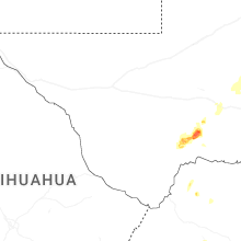
| 10:40 PM CDT | Quarter sized hail reported near Del Rio, TX, 3.5 miles E of Del Rio, TX, social media picture; val verde estates. |
| 10:50 PM CDT | Golf Ball sized hail reported near Laughlin A F B, TX, 6.5 miles E of Del Rio, TX, social media picture of estimated up to golfball size hail. |
| 11:05 PM CDT | Hwy 16 and jefferson street in kerrville blocked by a downed tree. time estimated on rada in kerr county TX, 58 miles NW of San Antonio, TX |
| 11:15 PM CDT | Awos station kerv kerrville muni arpt/louis schreiner fiel in kerr county TX, 52.4 miles NW of San Antonio, TX |
| 11:16 PM CDT | Texas tech mesonet observed a 62 mph wind gusts 9 ssw of comfor in kerr county TX, 39.6 miles NW of San Antonio, TX |
| 11:16 PM CDT | Multiple trees down in center point on river road center point. in addition... on springs and southerland road. time estimated on rada in kerr county TX, 48.8 miles NW of San Antonio, TX |
| 12:00 AM CDT | Measured wind gusts of up to 55-60 miles per hour. sustained winds of 20 miles per hour. winds were measured on personal home weather station. time estimate in bexar county TX, 14.2 miles N of San Antonio, TX |
| 4:37 AM CDT | Asos station kcrp corpus christ in nueces county TX, 6.2 miles WSW of Corpus Christi, TX |
Michigan
| Local Time | Report Details |
|---|---|
| 2:32 PM EDT | Several snapped trees at kensington metro par in oakland county MI, 33.3 miles S of Flint, MI |
| 2:33 PM EDT | Observed downed tree and large tree limb in oakland county MI, 32.7 miles S of Flint, MI |
| 2:35 PM EDT | Large tree fell across elizabeth lake road just west of williams lake roa in oakland county MI, 28.1 miles SSE of Flint, MI |
| 2:42 PM EDT | Large tree snapped. large tree limbs also blown down... one crushing portions of a campe in oakland county MI, 30.8 miles SSE of Flint, MI |
| 2:55 PM EDT | Trees and wires reported dow in livingston county MI, 36.6 miles SSW of Flint, MI |
| 3:04 PM EDT | Multiple trees down at stony creek metropark in macomb county MI, 37.5 miles ESE of Flint, MI |
| 3:07 PM EDT | Trees and wires reported down across portions of northern and northwest macomb county - corrected for time in macomb county MI, 38 miles ESE of Flint, MI |
| 3:39 PM EDT | Tree reported down... along with large tree limb in st. clair county MI, 56.3 miles ESE of Flint, MI |
| 3:50 PM EDT | Trees and wires reported down across portions of northern and northwest macomb county in macomb county MI, 38 miles ESE of Flint, MI |
| 4:18 PM EDT | Quarter sized hail reported near Detroit, MI, 47.6 miles SSE of Flint, MI, report of dime to quarter size hail |
| 4:22 PM EDT | A few large tree limbs and wires reported dow in macomb county MI, 50 miles SE of Flint, MI |
| 4:23 PM EDT | Estimated 60 mph thunderstorm wind gust and pea size hai in wayne county MI, 46.4 miles SSE of Flint, MI |
| 4:48 PM EDT | Storm damage reported in monroe county MI, 75.1 miles S of Flint, MI |
| 4:49 PM EDT | Report of a 20 to 30 ft tree down in wayne county MI, 56.9 miles SE of Flint, MI |
| 4:59 PM EDT | Storm damage reported in wayne county MI, 57.7 miles SE of Flint, MI |
Virginia
| Local Time | Report Details |
|---|---|
| 2:50 PM EDT | Several large tree limbs blew down along va-42 senedo road from va-263 orkney grade to the 10000 bloc in shenandoah county VA, 60.4 miles E of Elkins, WV |
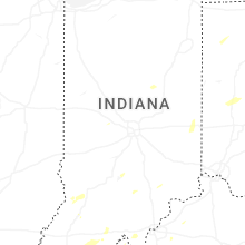
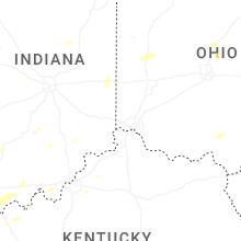
Indiana
| Local Time | Report Details |
|---|---|
| 3:57 PM EDT | Utility lines down. time roughly estimated from rada in hamilton county IN, 31.9 miles NNE of Indianapolis, IN |
| 4:11 PM EDT | A couple smaller trees and one large tree were blown down by thunderstorm winds. time is estimated from rada in hendricks county IN, 22.4 miles WNW of Indianapolis, IN |
| 4:32 PM EDT | A tree was blown down across a road by thunderstorm winds near the intersection of south county road 525 west and west county road 150 south southwest of danville. time in hendricks county IN, 25.1 miles W of Indianapolis, IN |
| 4:39 PM EDT | Broadcast media relayed photos from a viewer in jonesboro of numerous large branches broken and a trampoline in the trees. time estimated by rada in grant county IN, 49.6 miles SW of Fort Wayne, IN |
| 4:40 PM EDT | Tree downed in gas city on south 5th street. time estimated from rada in grant county IN, 49.1 miles SSW of Fort Wayne, IN |
| 4:52 PM EDT | Utility lines were blown down by thunderstorm winds. time estimated from rada in hamilton county IN, 16.1 miles N of Indianapolis, IN |
| 4:54 PM EDT | Downed utility lines on westfield blvd. time is estimated from rada in hamilton county IN, 13.4 miles N of Indianapolis, IN |
| 4:56 PM EDT | Tree fell on house and through the roof. north 11th street in noblesville. time has been estimated from rada in hamilton county IN, 20.9 miles NNE of Indianapolis, IN |
| 4:56 PM EDT | Corrects the time on the previous tstm wnd dmg report from 5 wsw lapel. utility pole is leaning from thunderstorm winds at olio road and sr38 in noblesville. time has b in hamilton county IN, 21.9 miles NE of Indianapolis, IN |
| 5:11 PM EDT | Tree across roadway on quarry court in fishers. time roughly estimated from rada in hamilton county IN, 17 miles NE of Indianapolis, IN |
| 5:14 PM EDT | Tree blown down by thunderstorm wind in hamilton county IN, 20.9 miles NE of Indianapolis, IN |
| 5:16 PM EDT | Utility pole is leaning from thunderstorm winds at olio road and sr38 in noblesvill in hamilton county IN, 21.9 miles NE of Indianapolis, IN |
| 5:33 PM EDT | Reports of blown over semi on i69 at mile marker 249 southbound lanes. time estimated from rada in delaware county IN, 50.4 miles NE of Indianapolis, IN |
| 5:45 PM EDT | Storm damage reported in bartholomew county IN, 37.4 miles SSE of Indianapolis, IN |
| 6:02 PM EDT | Trees down in centerville. time estimated from rada in wayne county IN, 55.9 miles NNW of Cincinnati, OH |
| 6:05 PM EDT | Quarter sized hail reported near Centerville, IN, 55.9 miles NNW of Cincinnati, OH, photo posted on social media. |
| 6:07 PM EDT | Trees down in richmond. time estimated from rada in wayne county IN, 54 miles NNW of Cincinnati, OH |
| 6:44 PM EDT | Leaning and snapped utility poles from photos on social medi in clark county IN, 23.6 miles N of Louisville, KY |
| 6:52 PM EDT | Tree down on power line. time estimated from rada in fayette county IN, 47.4 miles NW of Cincinnati, OH |
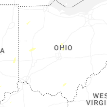
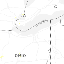
Ohio
| Local Time | Report Details |
|---|---|
| 4:27 PM EDT | Corrects previous tstm wnd dmg report from 3 wsw jackson. several trees down in the area. time is estimated from rada in jackson county OH, 65.9 miles SSE of Columbus, OH |
| 4:31 PM EDT | A couple utility poles were snapped in jackson. time is estimated from rada in jackson county OH, 65.8 miles SSE of Columbus, OH |
| 4:40 PM EDT | Power lines dow in jackson county OH, 65.5 miles SSE of Columbus, OH |
| 4:57 PM EDT | Tree downed on state route 61 in paulding county OH, 34.4 miles E of Fort Wayne, IN |
| 5:10 PM EDT | Damage to aluminum roofing at a manufacturing building. time estimated from rada in paulding county OH, 39.4 miles E of Fort Wayne, IN |
| 5:21 PM EDT | Large tree limb downed near wolfecale and dull robinson roa in van wert county OH, 25.8 miles ESE of Fort Wayne, IN |
| 5:23 PM EDT | Large trees downed onto a hous in henry county OH, 57.7 miles ENE of Fort Wayne, IN |
| 5:30 PM EDT | Large tree downed near washington and henry street. time estimated from rada in henry county OH, 57.7 miles ENE of Fort Wayne, IN |
| 5:41 PM EDT | Power poles down west and northwest of ottovill in putnam county OH, 39.8 miles ESE of Fort Wayne, IN |
| 5:44 PM EDT | Report of tree limbs down onto power lines in glandor in putnam county OH, 53.3 miles E of Fort Wayne, IN |
| 5:45 PM EDT | Wood county 911 dispatch reported 2 downed trees in pembervill in wood county OH, 88.4 miles ENE of Fort Wayne, IN |
| 6:04 PM EDT | Tree limb down on house. another tree down as wel in washington county OH, 71.9 miles ESE of Columbus, OH |
| 6:10 PM EDT | Picture shared on facebook by wlio of a large... partially rotten tree snapped into a yard at shawnee rd and dogwood driv in allen county OH, 55.4 miles ESE of Fort Wayne, IN |
| 6:18 PM EDT | A large tree branch fell onto a large propane tank... causing a propane lea in darke county OH, 59.2 miles NNW of Cincinnati, OH |
| 6:20 PM EDT | Hancock county 911 dispatch reported a downed tree limb in arcadi in hancock county OH, 82.5 miles E of Fort Wayne, IN |
| 6:23 PM EDT | Numerous trees and power lines down in southwest corner of darke county... all south of us-36. time estimated from rada in darke county OH, 62 miles N of Cincinnati, OH |
| 6:25 PM EDT | Tree down... cr 170 and 11 in sandusky county OH, 73.9 miles W of Cleveland, OH |
| 6:32 PM EDT | Metal roof damage. photos posted. time estimated by rada in darke county OH, 65.3 miles N of Cincinnati, OH |
| 6:39 PM EDT | Tree fell on 2 trailer in ottawa county OH, 56.5 miles W of Cleveland, OH |
| 6:55 PM EDT | Tree down on greenlee road. photo posted. time estimated by rada in miami county OH, 63.9 miles N of Cincinnati, OH |
| 6:55 PM EDT | Erie county 911 dispatch reported several tree limbs down in perkins townshi in erie county OH, 53 miles W of Cleveland, OH |
| 6:57 PM EDT | Trees down at ziegler and versailles roads. photos posted. time estimated from rada in miami county OH, 68.7 miles WNW of Columbus, OH |
| 6:58 PM EDT | Gust recorded on weather station. also noted tree and minor shingle damag in erie county OH, 51.2 miles W of Cleveland, OH |
| 7:13 PM EDT | Gust recorded on weather station. noted downed tree limbs onto powerline in erie county OH, 41.4 miles WSW of Cleveland, OH |
| 7:21 PM EDT | 2 foot diameter branches dow in butler county OH, 30.6 miles NNW of Cincinnati, OH |
| 7:37 PM EDT | Trees dow in logan county OH, 44.8 miles WNW of Columbus, OH |
| 8:02 PM EDT | Trees down across roadways as well as on power lines... at east church st and merchant av in marion county OH, 43.6 miles N of Columbus, OH |
| 8:07 PM EDT | Large healthy tree down. time estimated from rada in montgomery county OH, 40.5 miles NNE of Cincinnati, OH |
| 8:13 PM EDT | Top 20 feet of a very large tree dow in greene county OH, 43.5 miles NNE of Cincinnati, OH |
| 8:13 PM EDT | Tree down on upper bellbrook road and shepherd road. time estimated from rada in greene county OH, 46.4 miles NNE of Cincinnati, OH |
| 8:18 PM EDT | Tree down on us-6 in greene county OH, 47.5 miles NE of Cincinnati, OH |
| 8:21 PM EDT | Tree downed across south charleston road south of paullin road. video evidence from area residents indicate a gustnado crossed west-to-east across south charleston road in greene county OH, 42.5 miles WSW of Columbus, OH |
| 8:21 PM EDT | Tree down on galloway street. photo posted. time estimated from rada in greene county OH, 50.1 miles NE of Cincinnati, OH |
| 8:29 PM EDT | Around 20 trees were downed across the city of delaware... blocking multiple street in delaware county OH, 23.7 miles N of Columbus, OH |
| 8:31 PM EDT | Power lines down between jamestown and shawnee hills. time estimated from rada in greene county OH, 45.3 miles WSW of Columbus, OH |
| 8:31 PM EDT | 2 foot diameter limbs down. fence dow in greene county OH, 47.4 miles WSW of Columbus, OH |
| 8:33 PM EDT | Large tree downed across mineola ave near sunset view dr. time estimated via rada in summit county OH, 28.7 miles SSE of Cleveland, OH |
| 8:45 PM EDT | Tree limbs down and minor shed damage. time estimated from rada in madison county OH, 25.9 miles W of Columbus, OH |
| 9:30 PM EDT | One tree dow in fairfield county OH, 14.1 miles ESE of Columbus, OH |
| 9:54 PM EDT | One tree dow in fairfield county OH, 25 miles E of Columbus, OH |
Kentucky
| Local Time | Report Details |
|---|---|
| 4:45 PM EDT | Tree down blocking roadway on s 6th stree in jefferson county KY, 17.6 miles N of Louisville, KY |
| 4:45 PM EDT | Several trees down blocking the road on rose island roa in jefferson county KY, 26.2 miles NNE of Louisville, KY |
| 3:56 PM CDT | Quarter sized hail reported near Whitesville, KY, 44.9 miles ESE of Evansville, IN, reported on herbert road in herbert. |
| 6:02 PM EDT | Tree down on power line on fairview cour in henry county KY, 39.4 miles NE of Louisville, KY |
| 6:14 PM EDT | Multiple trees down and blocking the road near the 300 block of woods pike roa in henry county KY, 45.2 miles NE of Louisville, KY |
| 6:41 PM EDT | Photos via social media showed utility poles leaning along preston hwy. this resulting in power outage in jefferson county KY, 11.9 miles N of Louisville, KY |
| 6:41 PM EDT | Tree down blocking the roadwa in jefferson county KY, 12.7 miles N of Louisville, KY |
| 7:20 PM EDT | Trees down blocking roadways within the are in jefferson county KY, 23.2 miles NE of Louisville, KY |
| 7:32 PM EDT | Power lines down on jackson roa in henry county KY, 39.4 miles NE of Louisville, KY |
Connecticut
| Local Time | Report Details |
|---|---|
| 4:50 PM EDT | In burlington tree and wires reported down on johnnycake mountain road. relayed by amateur radi in hartford county CT, 82.2 miles W of Providence, RI |
| 4:50 PM EDT | In burlington tree and wires reported down on johnnycake mountain road. relayed by amateur radi in hartford county CT, 81.7 miles W of Providence, RI |
| 5:30 PM EDT | In vernon... a tree and power lines were down. relayed by amateur radi in tolland county CT, 54.1 miles W of Providence, RI |
| 5:35 PM EDT | In willington... a tree was down. relayed by amateur radi in tolland county CT, 45.6 miles W of Providence, RI |
| 5:58 PM EDT | In killingly... there was a tree and wires down on valley rd. relayed by amateur radi in windham county CT, 21.6 miles W of Providence, RI |
Massachusetts
| Local Time | Report Details |
|---|---|
| 5:11 PM EDT | In belchertown... a large tree and wires were down on michael sears rd and north liberty s in hampshire county MA, 56.6 miles WNW of Providence, RI |
| 5:15 PM EDT | In leicester a large tree was reported dow in worcester county MA, 38.7 miles NW of Providence, RI |
| 5:17 PM EDT | In lancaster tree and wires were reported down near havard road. relayed by amateur radi in worcester county MA, 45.9 miles NNW of Providence, RI |
| 5:20 PM EDT | Corrects previous tstm wnd dmg report from leicester. in leicester a large tree was reported dow in worcester county MA, 38.7 miles NW of Providence, RI |
| 5:24 PM EDT | Near maynard tree reported down on sudbury road. relayed by amateur radi in middlesex county MA, 42.5 miles N of Providence, RI |
| 5:26 PM EDT | In sudbury... a tree was down blocking half the road on hudson r in middlesex county MA, 39.1 miles N of Providence, RI |
| 5:28 PM EDT | *** 2 inj *** in concord a tree was reported down on a car. 2 minor injuries reported. relayed by amateur radi in middlesex county MA, 43.9 miles N of Providence, RI |
| 5:32 PM EDT | In hudson... a tree and wires were down on bertha st. relayed by amateur radi in middlesex county MA, 41.1 miles N of Providence, RI |
| 5:34 PM EDT | Peak gust of 59 kts or 68 mph reported at worcester airpor in worcester county MA, 39.3 miles NW of Providence, RI |
| 5:40 PM EDT | Near worcester a part of a rubber roof on amory building blew off. relayed by amateur radi in worcester county MA, 37.4 miles NNW of Providence, RI |
| 5:45 PM EDT | In paxton... trees and wires were down on multiple streets including holbrook ln and west s in worcester county MA, 43.2 miles NW of Providence, RI |
| 6:00 PM EDT | Corrects previous tstm wnd dmg report from oxford. in oxford trees and wires were reported down in multiple locations including on cars. relayed by amateur radi in worcester county MA, 31.2 miles NW of Providence, RI |
| 6:00 PM EDT | In northborough on west street trees and wires were reported down. relayed by amateur radi in worcester county MA, 35.5 miles NNW of Providence, RI |
| 6:05 PM EDT | In sutton... a tree was down on wires causing them to catch on fir in worcester county MA, 28.2 miles NW of Providence, RI |
| 6:15 PM EDT | In needham on great plain avenue near the golf course a large tree branch was reported down. relayed by amateur radi in norfolk county MA, 32.8 miles NNE of Providence, RI |
| 6:24 PM EDT | In milton... a tree was down on a car on ford ranch r in norfolk county MA, 32.8 miles NNE of Providence, RI |
| 6:25 PM EDT | In norfolk... wires were down on cleveland st. relayed by amateur radi in norfolk county MA, 22.2 miles N of Providence, RI |
New Hampshire
| Local Time | Report Details |
|---|---|
| 5:19 PM EDT | Appledore islan in anz154 county NH, 51 miles SSW of Portland, ME |
West Virginia
| Local Time | Report Details |
|---|---|
| 6:00 PM EDT | Tree limb went through roof of house and water pouring into hous in wood county WV, 53.3 miles N of Charleston, WV |
Louisiana
| Local Time | Report Details |
|---|---|
| 5:30 PM CDT | Several trees dow in bienville county LA, 38.6 miles E of Shreveport, LA |
New York
| Local Time | Report Details |
|---|---|
| 8:05 PM EDT | Large tree branch downed several lines at oneida st. and rudlen roa in niagara county NY, 21.9 miles NNW of Buffalo, NY |
| 8:08 PM EDT | Tree and several wires down on upper mountain roa in niagara county NY, 20.6 miles NNW of Buffalo, NY |
| 8:12 PM EDT | Tree fell down on wheatfield street... partially blocking traffi in niagara county NY, 10.7 miles N of Buffalo, NY |
| 8:20 PM EDT | Tree downed on thompson road between roll road and greiner roa in erie county NY, 13.7 miles ENE of Buffalo, NY |
| 8:21 PM EDT | Tree down across jefferson d in niagara county NY, 21.2 miles NNE of Buffalo, NY |
| 8:22 PM EDT | Tree down on campbell blv in niagara county NY, 13.9 miles NNE of Buffalo, NY |
| 8:27 PM EDT | Large tree down across north transit stree in niagara county NY, 22.3 miles NNE of Buffalo, NY |
| 8:27 PM EDT | Large tree and wires down on telegraph rd near vernon stree in niagara county NY, 30 miles NE of Buffalo, NY |
| 8:28 PM EDT | Tree and wires down near akron st. and davison r in niagara county NY, 21.7 miles NNE of Buffalo, NY |
| 8:30 PM EDT | Tree brought down lines on quaker roa in niagara county NY, 33.7 miles NNE of Buffalo, NY |
| 8:32 PM EDT | Tree down in shelb in orleans county NY, 30.4 miles NE of Buffalo, NY |
| 8:33 PM EDT | Trees and wires down in ridgewa in orleans county NY, 36.3 miles NE of Buffalo, NY |
| 8:47 PM EDT | Tree down in albio in orleans county NY, 43 miles NE of Buffalo, NY |
| 8:52 PM EDT | Tree down blocking traffic on ridge roa in orleans county NY, 50.1 miles ENE of Buffalo, NY |
| 9:15 PM EDT | Home weather station in hilton recorded a 51mph wind gust with several trees and power lines down in the neighborhoo in monroe county NY, 61.7 miles ENE of Buffalo, NY |
Connect with Interactive Hail Maps