

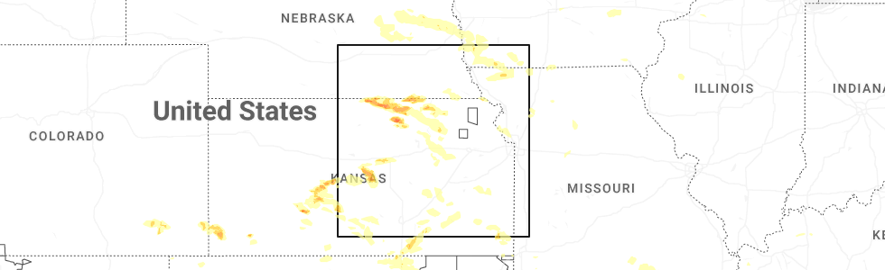
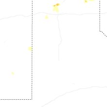
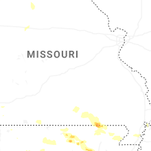
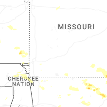
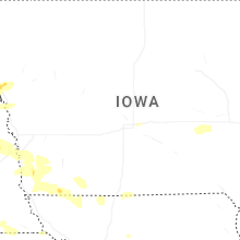
Hail Map for Saturday, June 13, 2026
Number of Impacted Households on 6/13/2026
0
Impacted by 1" or Larger Hail
0
Impacted by 1.75" or Larger Hail
0
Impacted by 2.5" or Larger Hail
Square Miles of Populated Area Impacted on 6/13/2026
0
Impacted by 1" or Larger Hail
0
Impacted by 1.75" or Larger Hail
0
Impacted by 2.5" or Larger Hail
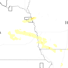
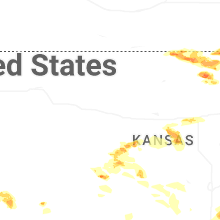
Cities Most Affected by Hail Storms of 6/13/2026
| Hail Size | Demographics of Zip Codes Affected | ||||||
|---|---|---|---|---|---|---|---|
| City | Count | Average | Largest | Pop Density | House Value | Income | Age |
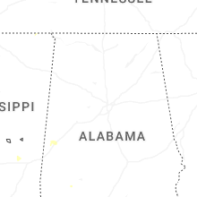
| Winfield, KS | 5 | 2.70 | 4.00 | 57 | $63k | $36.6k | 39.0 |
| Cord, AR | 2 | 2.25 | 2.50 | 5 | $62k | $30.2k | 44.8 |
| Concordia, KS | 2 | 1.88 | 2.00 | 26 | $50k | $32.4k | 40.6 |
| Albert, KS | 1 | 2.50 | 2.50 | 2 | $44k | $37.1k | 50.2 |
| Geneseo, KS | 1 | 2.00 | 2.00 | 3 | $26k | $26.5k | 51.4 |
| Big Cabin, OK | 1 | 2.00 | 2.00 | 26 | $57k | $32.2k | 42.1 |
| Hollenberg, KS | 1 | 2.00 | 2.00 | 2 | $14k | $31.3k | 47.8 |
| Webber, KS | 1 | 1.75 | 1.75 | 2 | $26k | $26.8k | 56.6 |
| Blackwell, OK | 1 | 1.75 | 1.75 | 83 | $37k | $26.3k | 39.4 |
Hail and Wind Damage Spotted on 6/13/2026
Filter by Report Type:Hail ReportsWind Reports
States Impacted
Iowa, Nebraska, Missouri, Michigan, Arkansas, Georgia, South Carolina, Kansas, Tennessee, Kentucky, North Carolina, Oklahoma, Utah, Texas, IllinoisIowa
| Local Time | Report Details |
|---|---|
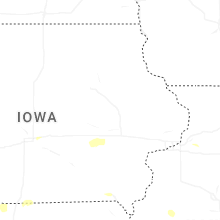
| 7:46 AM CDT | Ping Pong Ball sized hail reported near Sloan, IA, 59.6 miles WSW of Storm Lake, IA |
| 8:45 AM CDT | Quarter sized hail reported near Council Bluffs, IA, 6.7 miles SE of Omaha, NE, picture of 1 inch hail via facebook. |
| 9:25 AM CDT | Quarter sized hail reported near Hastings, IA, 28.4 miles SE of Omaha, NE, quarter size hail in the hillsdale area via facebook. time estimated on radar. |
| 9:35 AM CDT | Damage to gutte in montgomery county IA, 40.6 miles ESE of Omaha, NE |
| 9:52 AM CDT | Storm damage reported in montgomery county IA, 54.5 miles ESE of Omaha, NE |
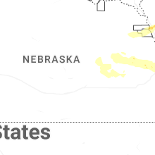
Nebraska
| Local Time | Report Details |
|---|---|
| 8:01 AM CDT | Strong winds caused power outage in mead via report on facebook. time estimated from rada in saunders county NE, 28.7 miles W of Omaha, NE |
| 8:05 AM CDT | Picture of large tree snapped in half from inglewood reported via faceboo in dodge county NE, 31.1 miles WNW of Omaha, NE |
| 8:14 AM CDT | Quarter sized hail reported near Fremont, NE, 31.1 miles WNW of Omaha, NE, report from mping: quarter (1.00 in.). |
| 8:15 AM CDT | Quarter sized hail reported near Fremont, NE, 31.1 miles WNW of Omaha, NE, quarter-size hail being wind driven. |
| 8:19 AM CDT | Corrects time from previous tstm wnd gst report from 1 nw valle in douglas county NE, 22.9 miles WNW of Omaha, NE |
| 8:20 AM CDT | Storm damage reported in douglas county NE, 23 miles WNW of Omaha, NE |
| 8:21 AM CDT | Several reports of an awning damaged at a gas station at 156th and maple via faceboo in douglas county NE, 11.6 miles W of Omaha, NE |
| 8:23 AM CDT | Quarter sized hail reported near Elkhorn, NE, 16.3 miles W of Omaha, NE, report from mping: quarter (1.00 in.). |
| 8:24 AM CDT | Storm damage reported in douglas county NE, 22.9 miles WNW of Omaha, NE |
| 8:27 AM CDT | Gusts 55-60 mph with dime-size hai in douglas county NE, 15.7 miles W of Omaha, NE |
| 8:29 AM CDT | Quarter sized hail reported near Elkhorn, NE, 14.6 miles W of Omaha, NE |
| 8:30 AM CDT | Storm damage reported in douglas county NE, 14.6 miles W of Omaha, NE |
| 8:30 AM CDT | Quarter sized hail reported near Omaha, NE, 10.9 miles WNW of Omaha, NE |
| 8:30 AM CDT | Wind caused a tree fire and blew the power. reported via facebook. time estimated via rada in douglas county NE, 6.3 miles W of Omaha, NE |
| 8:40 AM CDT | Quarter sized hail reported near Bellevue, NE, 7.3 miles SSE of Omaha, NE, quarter-size hail and strong winds. small limbs down. |
| 8:40 AM CDT | Quarter sized hail reported near Bellevue, NE, 7 miles S of Omaha, NE |
| 3:53 PM CDT | Quarter sized hail reported near Superior, NE, 65.5 miles SSE of Grand Island, NE |
| 4:22 PM CDT | Quarter sized hail reported near Superior, NE, 66.9 miles S of Grand Island, NE |
| 4:25 PM CDT | Quarter sized hail reported near Superior, NE, 67 miles SSE of Grand Island, NE, second round of hail dropped hail up to quarter size...time approximated from report and radar. |
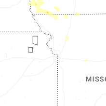
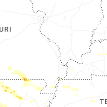
Missouri
| Local Time | Report Details |
|---|---|
| 11:32 AM CDT | Mping report of downed tree limbs in bethany. time confirmed from rada in harrison county MO, 85.7 miles NNE of Kansas City, MO |
| 1:40 PM CDT | Half Dollar sized hail reported near Doniphan, MO, 76.9 miles SSE of Salem, MO, time estimated via radar. report received via social media. |
| 8:05 PM CDT | Relayed report of downed trees partially in the road. time estimated from rada in platte county MO, 23.8 miles NW of Kansas City, MO |
| 8:15 PM CDT | Outage reported due to storm damage... time estimated from rada in platte county MO, 21 miles NW of Kansas City, MO |
| 8:20 PM CDT | Downed tree near apple blossom drive. time estimated from rada in platte county MO, 18.9 miles NW of Kansas City, MO |
| 8:21 PM CDT | Mping report of downed tree limbs near oak creek court. time confirmed from rada in platte county MO, 11.2 miles NW of Kansas City, MO |
| 8:22 PM CDT | Shingles blown off a residence near oak creek court. time estimated from rada in platte county MO, 11.2 miles NW of Kansas City, MO |
| 8:22 PM CDT | Public relayed photo of large tree branch down. time estimated from rada in platte county MO, 11.7 miles NNW of Kansas City, MO |
| 8:22 PM CDT | Photos shared of several large tree branches down... time estimated by rada in platte county MO, 11.4 miles NNW of Kansas City, MO |
| 8:24 PM CDT | Public relayed photo of large tree branch obstructing road. time estimated from rada in platte county MO, 8.2 miles NNW of Kansas City, MO |
| 8:24 PM CDT | Public relayed photo of large tree branch down. time estimated from rada in platte county MO, 10.9 miles NNW of Kansas City, MO |
| 8:24 PM CDT | Downed trees and wires in several locations near platte city. time estimated from rada in platte county MO, 21.2 miles NNW of Kansas City, MO |
| 8:25 PM CDT | Public related photo of tree down... describes damage as broken halfway up the trunk. time estimated from rada in platte county MO, 15 miles NNW of Kansas City, MO |
| 8:25 PM CDT | Multiple trees... power lines... and street signs down just east of kci airport. time estimated from rada in platte county MO, 13.9 miles NNW of Kansas City, MO |
| 8:29 PM CDT | Public relayed photo of large tree branches down... time estimated from rada in clay county MO, 10.8 miles N of Kansas City, MO |
| 8:29 PM CDT | Mping report of downed tree limbs near 68th terrace. time estimated from rada in platte county MO, 8.8 miles NNW of Kansas City, MO |
| 8:30 PM CDT | Asos station kmci kansas city int in platte county MO, 15.7 miles NNW of Kansas City, MO |
| 8:30 PM CDT | Large tree down over the road at northwood road and north merrimac avenu in platte county MO, 5.9 miles NNW of Kansas City, MO |
| 8:30 PM CDT | Public relayed photo of downed tree obstructing the off ramp. time estimated from rada in jackson county MO, 0.7 miles ESE of Kansas City, MO |
| 8:30 PM CDT | Multiple photos relayed of large tree branches down. time estimated from rada in clay county MO, 10.9 miles N of Kansas City, MO |
| 8:31 PM CDT | Public relayed photo of tree down... obstructing road. time estimated from rada in jackson county MO, 0.5 miles NNE of Kansas City, MO |
| 8:32 PM CDT | Several trees and limbs down in the tiffany springs area. time estimated from rada in platte county MO, 13.4 miles NW of Kansas City, MO |
| 8:32 PM CDT | Reported power outage due to storm damage. time estimated from rada in clay county MO, 7.5 miles N of Kansas City, MO |
| 8:33 PM CDT | Mping report of downed tree limbs near bedford avenue. time estimated from rada in platte county MO, 8.1 miles N of Kansas City, MO |
| 8:33 PM CDT | Mping report of uprooted trees near 76th street. time estimated from rada in platte county MO, 9.1 miles NNW of Kansas City, MO |
| 8:33 PM CDT | Public relayed report of large tree branches down on power line. time estimated from rada in jackson county MO, 3.2 miles SE of Kansas City, MO |
| 8:34 PM CDT | Photo shared of large tree branches down. time estimated from rada in clay county MO, 6.4 miles NNE of Kansas City, MO |
| 8:36 PM CDT | Mping report of downed tree limbs near indiana avenue. time estimated from rada in clay county MO, 10.4 miles NNE of Kansas City, MO |
| 8:36 PM CDT | Mping report of downed power poles. time estimated from rada in jackson county MO, 3.7 miles ESE of Kansas City, MO |
| 8:36 PM CDT | Downed tree limbs near i-435 and u.s. 169. time estimated from rada in clay county MO, 14.3 miles N of Kansas City, MO |
| 8:36 PM CDT | Time estimated from rada in clay county MO, 9.7 miles NNE of Kansas City, MO |
| 8:38 PM CDT | Large tree blown onto the road near the intersection of russell road and cleveland avenue. time estimated from rada in clay county MO, 5.2 miles NNE of Kansas City, MO |
| 8:38 PM CDT | Mping report of downed tree limbs near topping avenue. time estimated from rada in jackson county MO, 4.2 miles ESE of Kansas City, MO |
| 8:41 PM CDT | Public relayed video of large tree branches down. time estimated from rada in jackson county MO, 9.4 miles SE of Kansas City, MO |
| 8:42 PM CDT | Public relayed video of large tree branch down. time estimated from rada in jackson county MO, 8.4 miles E of Kansas City, MO |
| 8:42 PM CDT | Public relayed photo of large tree branch/tree down... time estimated from rada in clay county MO, 14.3 miles NNE of Kansas City, MO |
| 8:42 PM CDT | Mping report of downed tree limbs near 96th street. time confirmed from rada in clay county MO, 11.6 miles N of Kansas City, MO |
| 8:42 PM CDT | Sign overturned on i-435. time estimated from rada in jackson county MO, 4.8 miles ENE of Kansas City, MO |
| 8:42 PM CDT | Public relayed report of large tree branch down. time estimated from rada in clay county MO, 7.8 miles NE of Kansas City, MO |
| 8:44 PM CDT | Public relayed photo of large tree branch down... obstructing road. time estimated from rada in jackson county MO, 7.2 miles E of Kansas City, MO |
| 8:45 PM CDT | Large tree down near 39th street. time confirmed from rada in jackson county MO, 13.1 miles ESE of Kansas City, MO |
| 8:45 PM CDT | Time estimated from rada in jackson county MO, 10.9 miles SSE of Kansas City, MO |
| 8:46 PM CDT | Public shared photo of large tree branch down. time estimated from rada in clay county MO, 13.1 miles NE of Kansas City, MO |
| 8:46 PM CDT | Public relayed photos of large tree branches down in house. time estimated from rada in jackson county MO, 11.2 miles ESE of Kansas City, MO |
| 8:47 PM CDT | Public relayed photos of large tree branches down... obstructing roads and impacting structures. time estimated by rada in clay county MO, 13.3 miles NE of Kansas City, MO |
| 8:47 PM CDT | Mping report of downed tree limbs near 103rd street. time confirmed from rada in clay county MO, 13 miles NNE of Kansas City, MO |
| 8:47 PM CDT | Public shared photo of large tree branch down in road. time estimated from rada in clay county MO, 11.9 miles NE of Kansas City, MO |
| 8:48 PM CDT | Public relayed photo of two large metal clothing bins blown over. time estimated from rada in clay county MO, 12.2 miles NE of Kansas City, MO |
| 8:48 PM CDT | Private weather senso in clay county MO, 11.6 miles NNE of Kansas City, MO |
| 8:48 PM CDT | Downed tree limbs throughout independence. time estimated from rada in jackson county MO, 8.8 miles E of Kansas City, MO |
| 8:48 PM CDT | Downed tree near i-70 and lees summit road. time estimated from rada in jackson county MO, 11.3 miles ESE of Kansas City, MO |
| 8:48 PM CDT | Mping report of downed tree limbs near 43rd street. time estimated from rada in jackson county MO, 9.3 miles ESE of Kansas City, MO |
| 8:49 PM CDT | Downed tree limbs and wires near u.s. 69. time estimated from rada in clay county MO, 17.8 miles NE of Kansas City, MO |
| 8:49 PM CDT | Private weather senso in clay county MO, 15.8 miles NNE of Kansas City, MO |
| 8:50 PM CDT | Downed tree limbs near 136th street. time estimated from rada in clay county MO, 18.1 miles NNE of Kansas City, MO |
| 8:50 PM CDT | Several road barricades and multiple trees blown down in liberty. time estimated from rada in clay county MO, 13.4 miles NE of Kansas City, MO |
| 8:50 PM CDT | Multiple trees snapped or uprooted on south side of liberty. time estimated from rada in clay county MO, 12.9 miles NE of Kansas City, MO |
| 8:50 PM CDT | Public relayed photo of large tree branches down. time estimated from rada in jackson county MO, 12 miles E of Kansas City, MO |
| 8:51 PM CDT | Private weather senso in clay county MO, 15 miles NNE of Kansas City, MO |
| 8:53 PM CDT | Public relayed photo of large tree branch down. time estimated from rada in clay county MO, 19.1 miles NE of Kansas City, MO |
| 8:53 PM CDT | Mping report of downed tree limbs near route 7. time estimated from rada in jackson county MO, 16.3 miles E of Kansas City, MO |
| 8:53 PM CDT | Private weather senso in jackson county MO, 11.7 miles ENE of Kansas City, MO |
| 8:53 PM CDT | Time estimated from rada in jackson county MO, 13.5 miles ESE of Kansas City, MO |
| 8:56 PM CDT | Downed tree limbs near route 7. time estimated from rada in jackson county MO, 18 miles ESE of Kansas City, MO |
| 8:56 PM CDT | Public relayed photo of tree branch split off from trunk... time estimated from rada in clay county MO, 20.3 miles NE of Kansas City, MO |
| 8:58 PM CDT | Mping report of downed tree libs near galazxy drive. time estimated from rada in cass county MO, 22.3 miles SSE of Kansas City, MO |
| 8:58 PM CDT | Mping report of downed tree limbs near alexander road. time estimated from rada in jackson county MO, 12.6 miles E of Kansas City, MO |
| 9:00 PM CDT | Downed tree limbs throughout town. time estimated from rada in clay county MO, 22 miles NNE of Kansas City, MO |
| 9:00 PM CDT | Mping report of downed tree limbs near oxford lane. time estimated from rada in jackson county MO, 16.5 miles ESE of Kansas City, MO |
| 9:02 PM CDT | No damage observed so fa in clay county MO, 21.7 miles NE of Kansas City, MO |
| 9:05 PM CDT | Storm damage reported in cass county MO, 26.7 miles SE of Kansas City, MO |
| 9:08 PM CDT | Public shared photo of large tree branch down on road. time estimated from rada in jackson county MO, 21.1 miles ENE of Kansas City, MO |
| 9:09 PM CDT | Public relayed photo of trees blocking road... location/time estimated from rada in jackson county MO, 20 miles ENE of Kansas City, MO |
| 9:12 PM CDT | Time estimated from rada in jackson county MO, 25.2 miles ESE of Kansas City, MO |
| 9:12 PM CDT | Downed tree and power line near clearview drive. time estimated from rada in cass county MO, 28.3 miles SE of Kansas City, MO |
| 9:17 PM CDT | Public relayed report of several large tree branches down... time estimated from rada in lafayette county MO, 28.3 miles ESE of Kansas City, MO |
| 9:20 PM CDT | Public relayed photo of tree split. time estimated from rada in ray county MO, 35.1 miles ENE of Kansas City, MO |
| 9:28 PM CDT | Mping report of downed tree limbs. time estimated from rada in ray county MO, 30.3 miles ENE of Kansas City, MO |
| 9:31 PM CDT | A 2-foot-diameter tree fell on a house. time estimated from rada in lafayette county MO, 32.5 miles E of Kansas City, MO |
| 9:37 PM CDT | Mping report of downed tree limbs. time estimated from rada in lafayette county MO, 37.4 miles E of Kansas City, MO |
| 9:48 PM CDT | Private weather senso in lafayette county MO, 47 miles E of Kansas City, MO |
| 9:52 PM CDT | Downed trees northeast of fayetteville. time estimated from rada in johnson county MO, 49.2 miles ESE of Kansas City, MO |
| 9:59 PM CDT | Mping report of downed tree limbs near route 23. time estimated from rada in lafayette county MO, 55.3 miles E of Kansas City, MO |
| 10:02 PM CDT | Mping report of downed tree limbs. time estimated from rada in lafayette county MO, 55.3 miles E of Kansas City, MO |
| 10:02 PM CDT | Mping report of downed tree limbs near route d. time estimated from rada in johnson county MO, 61 miles ESE of Kansas City, MO |
| 10:05 PM CDT | Downed tree limb and power lines near northeast 75. time estimated from rada in johnson county MO, 60.2 miles ESE of Kansas City, MO |
| 10:07 PM CDT | Private weather senso in lafayette county MO, 55.8 miles E of Kansas City, MO |
| 10:29 PM CDT | Mping report of power poles damaged and power lines down. time estimated from rada in saline county MO, 53.4 miles WNW of Columbia, MO |
| 10:32 PM CDT | Metal roofing from a garage was lifted and blown across the street. time estimated from rada in pettis county MO, 51.1 miles WSW of Columbia, MO |
| 11:31 PM CDT | Tree down at school street and route 59. time estimated by rada in mcdonald county MO, 71 miles WSW of Springfield, MO |
| 11:32 PM CDT | Report of downed tree branch blocking roadway. time estimated from rada in saline county MO, 47.8 miles WNW of Columbia, MO |
| 11:34 PM CDT | 4 miles south of carthage just north of i44 report of 80 mph wind in jasper county MO, 56.2 miles W of Springfield, MO |
| 11:37 PM CDT | Tree down on route d a half mile south of mcdonald roa in mcdonald county MO, 59.4 miles WSW of Springfield, MO |
| 11:40 PM CDT | Power lines and limbs dow in jasper county MO, 62.3 miles W of Springfield, MO |
| 11:41 PM CDT | Front porch blown off a house in fidelity 2 miles west of apple road and i4 in jasper county MO, 57 miles W of Springfield, MO |
| 11:45 PM CDT | Measured 84mph winds through neosho on ridgewood road at 11:45p in newton county MO, 64 miles WSW of Springfield, MO |
| 11:56 PM CDT | Large tree limbs dow in jasper county MO, 62.3 miles W of Springfield, MO |
| 12:07 AM CDT | Numerous power lines down across the city of jopli in jasper county MO, 66 miles SE of Chanute, KS |
| 12:28 AM CDT | Corrects previous non-tstm wnd dmg report from 4 nnw ritchey. power lines down and tree debris across the roads reported from storm spotter in newton county MO, 52.9 miles WSW of Springfield, MO |
| 12:37 AM CDT | Butterfield fire is reporting power lines down at hwy 37 and hwy u on social medi in barry county MO, 47 miles SW of Springfield, MO |
| 12:57 AM CDT | Tree down... about 40 inch wide on a hous in jasper county MO, 65.1 miles SE of Chanute, KS |
| 1:59 AM CDT | Tree over the roadway at the corner of e benton ave and malone st. time estimated by rada in douglas county MO, 39.2 miles ESE of Springfield, MO |
| 1:59 AM CDT | Large tree down on east broadway in ava. time estimated by rada in douglas county MO, 38.9 miles ESE of Springfield, MO |
| 2:09 AM CDT | Limbs from 1 up to 6 inch snapped... roofs off of some businesses... and minor shingle damag in jasper county MO, 64.8 miles SE of Chanute, KS |
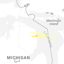
Michigan
| Local Time | Report Details |
|---|---|
| 1:58 PM EDT | Quarter sized hail reported near Mikado, MI, 32 miles S of Alpena, MI, broadcast media shared photo of quarter size hail. time estimated. |
| 2:05 PM EDT | Quarter sized hail reported near Alpena, MI, 0.9 miles NE of Alpena, MI, broadcast media relayed pictures showing quarter size hail in alpena. time estimated. |
| 2:20 PM EDT | Quarter sized hail reported near Herron, MI, 11.9 miles WSW of Alpena, MI, broadcast media relayed photos of quarter size hail near herron. time estimated. |
| 2:30 PM EDT | Quarter sized hail reported near Ossineke, MI, 7.7 miles S of Alpena, MI, social media photos shared of quarter size hail approximately 10 miles south of alpena. time estimated via radar. |
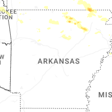
Arkansas
| Local Time | Report Details |
|---|---|
| 2:14 PM CDT | Quarter sized hail reported near Melbourne, AR, 92.6 miles NNE of Little Rock, AR, quarter-sized hail reported at izard county sheriff dept. |
| 3:35 PM CDT | Tennis Ball sized hail reported near Cord, AR, 86.2 miles WNW of Memphis, TN |
| 3:40 PM CDT | Hen Egg sized hail reported near Cord, AR, 85.9 miles WNW of Memphis, TN |
| 5:45 PM CDT | Tree limbs blown dow in cleburne county AR, 56.2 miles N of Little Rock, AR |
| 7:30 PM CDT | Quarter sized hail reported near Maysville, AR, 70.7 miles N of Fort Smith, AR |
| 7:35 PM CDT | Large tree branch down in maysville. report relayed via broadcast medi in benton county AR, 70.7 miles N of Fort Smith, AR |
| 7:57 PM CDT | Tree down on some wires in the 500 block of n byers in gentr in benton county AR, 61.1 miles N of Fort Smith, AR |
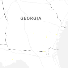
Georgia
| Local Time | Report Details |
|---|---|
| 3:40 PM EDT | Photos via social media of damage to several sheds at a local business in waycross... including more than one flipped on its side. time estimated via rada in ware county GA, 37.2 miles SE of Douglas, GA |
| 7:15 PM EDT | Social media report of trees down in the fitzgerald are in ben hill county GA, 27.8 miles WNW of Douglas, GA |
| 7:23 PM EDT | Several trees and power lines down across ben hill count in ben hill county GA, 21.3 miles NW of Douglas, GA |
| 8:01 PM EDT | Tree down on cornelius roa in berrien county GA, 34.4 miles SW of Douglas, GA |
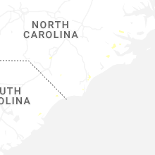
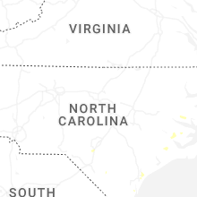
South Carolina
| Local Time | Report Details |
|---|---|
| 4:19 PM EDT | A tree was brought down across utility lines and a hous in horry county SC, 49.3 miles WSW of Wilmington, NC |
| 6:40 PM EDT | South carolina highway patrol reported a tree down in the roadway near the intersection of cottageville highway and featherbed road. the tree is likely down due to thun in colleton county SC, 37.7 miles WSW of Charleston, SC |
| 6:45 PM EDT | Colleton county emergency management reported a tree down in the 10600 block of round o roa in colleton county SC, 35.7 miles WSW of Charleston, SC |
| 6:53 PM EDT | Colleton county emergency management reported a tree down on round o road near the intersection with dodds farm lan in colleton county SC, 35.9 miles WSW of Charleston, SC |
| 6:53 PM EDT | Colleton county emergency management reported a tree down on a residence in the 400 block of bowman lan in colleton county SC, 43.4 miles SW of Charleston, SC |
| 6:56 PM EDT | Colleton county emergency management reported a tree down near the intersection of ritter road and bonnie doone roa in colleton county SC, 42 miles SW of Charleston, SC |
| 6:56 PM EDT | Colleton county emergency management reported a tree down on nettles lan in colleton county SC, 41.6 miles SW of Charleston, SC |
| 7:05 PM EDT | Colleton county emergency management reported a tree down near the intersection of round o road and jacksonboro road. the tree is likely down due to thunderstorm outflo in colleton county SC, 35.7 miles SW of Charleston, SC |
| 7:17 PM EDT | Colleton county emergency management reported a tree down in the 1700 block of wiggins road. the tree is likely down due to thunderstorm outflo in colleton county SC, 47.3 miles NNE of Savannah, GA |
| 7:17 PM EDT | Colleton county emergency management reported a tree down on ritter road near the intersection with saxby hill roa in colleton county SC, 44.6 miles SW of Charleston, SC |
| 7:25 PM EDT | South carolina highway patrol reported a tree down on ritter road near the intersection with possum corner road. the tree is likely down due to thunderstorm outflo in colleton county SC, 45.9 miles SW of Charleston, SC |
| 7:30 PM EDT | South carolina highway patrol reported a tree down on wood road. the tree is likely down due to thunderstorm outflo in colleton county SC, 46.4 miles SW of Charleston, SC |
| 7:50 PM EDT | Colleton county emergency management reported a tree down on green pond highway near chicken farm lan in colleton county SC, 46.4 miles SW of Charleston, SC |
| 8:00 PM EDT | Colleton county emergency management reported a tree down near the intersection of wood road and jacqui rabbit roa in colleton county SC, 46.8 miles SW of Charleston, SC |
| 8:00 PM EDT | Colleton county emergency management reported a tree down on green pond highway near the intersection with spring hill roa in colleton county SC, 47.3 miles SW of Charleston, SC |
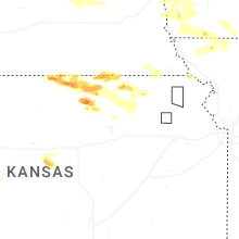
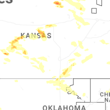
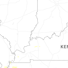
Kansas
| Local Time | Report Details |
|---|---|
| 3:45 PM CDT | Quarter sized hail reported near Burr Oak, KS, 65.9 miles S of Grand Island, NE, report received via facebook. |
| 4:09 PM CDT | Ping Pong Ball sized hail reported near Courtland, KS, 68.2 miles SSE of Grand Island, NE, hail covered the ground. |
| 4:33 PM CDT | Half Dollar sized hail reported near Webber, KS, 69.5 miles SSE of Grand Island, NE |
| 4:33 PM CDT | Quarter sized hail reported near Webber, KS, 71.2 miles SSE of Grand Island, NE, report received via facebook. |
| 4:35 PM CDT | Golf Ball sized hail reported near Webber, KS, 72.3 miles SSE of Grand Island, NE, penny to golf ball size hail reported. |
| 4:55 PM CDT | Hen Egg sized hail reported near Hollenberg, KS, 59.2 miles NNW of Manhattan, KS, report on spotter network of two inch hail. |
| 5:07 PM CDT | Quarter sized hail reported near Belleville, KS, 72.6 miles NW of Manhattan, KS |
| 5:07 PM CDT | Quarter sized hail reported near Sublette, KS, 38.6 miles S of Garden City, KS |
| 5:10 PM CDT | Quarter sized hail reported near Belleville, KS, 75.2 miles NW of Manhattan, KS, increased from pea to quarter size hail over 10 minutes. |
| 5:23 PM CDT | Quarter sized hail reported near Marysville, KS, 46.8 miles NNW of Manhattan, KS |
| 5:32 PM CDT | Golf Ball sized hail reported near Concordia, KS, 58 miles WNW of Manhattan, KS, sheriffs office relayed report of golf ball size hail on highway 9 west of clyde. location estimated from radar. |
| 5:33 PM CDT | Quarter sized hail reported near Marysville, KS, 45.2 miles N of Manhattan, KS, also 50-60 mph winds. |
| 5:33 PM CDT | Also with 1 inch hai in marshall county KS, 45.2 miles N of Manhattan, KS |
| 5:39 PM CDT | Hen Egg sized hail reported near Concordia, KS, 54.7 miles WNW of Manhattan, KS, along highway 9. |
| 6:08 PM CDT | Storm damage reported in marshall county KS, 37.4 miles NNE of Manhattan, KS |
| 6:10 PM CDT | Union pacific observation sit in marshall county KS, 50.5 miles NNE of Manhattan, KS |
| 6:16 PM CDT | Estimated speed of strong wind gust in riley county KS, 20.3 miles NNW of Manhattan, KS |
| 6:25 PM CDT | Ping Pong Ball sized hail reported near Spearville, KS, 61.9 miles E of Garden City, KS, report made through social media. |
| 6:27 PM CDT | Along with nickel size hai in pottawatomie county KS, 17.8 miles NNW of Manhattan, KS |
| 6:27 PM CDT | Several large trees dow in pottawatomie county KS, 18 miles NNW of Manhattan, KS |
| 6:28 PM CDT | Quarter sized hail reported near Spearville, KS, 61.9 miles E of Garden City, KS |
| 6:32 PM CDT | Quarter sized hail reported near Geneseo, KS, 66.2 miles ESE of Hays, KS, kwch media report. |
| 6:37 PM CDT | Hen Egg sized hail reported near Geneseo, KS, 68.1 miles ESE of Hays, KS, time estimated by radar. |
| 6:39 PM CDT | Quarter sized hail reported near Rozel, KS, 46.4 miles S of Hays, KS |
| 6:42 PM CDT | Ping Pong Ball sized hail reported near Albert, KS, 33.9 miles SSE of Hays, KS |
| 6:43 PM CDT | Tennis Ball sized hail reported near Albert, KS, 33.3 miles SSE of Hays, KS |
| 6:44 PM CDT | Half Dollar sized hail reported near Geneseo, KS, 67.8 miles ESE of Hays, KS |
| 6:49 PM CDT | Quarter sized hail reported near Rozel, KS, 52.6 miles S of Hays, KS |
| 6:50 PM CDT | Personal weather statio in riley county KS, 2.8 miles N of Manhattan, KS |
| 6:50 PM CDT | Tennis Ball sized hail reported near Winfield, KS, 33.9 miles SSE of Wichita, KS |
| 6:52 PM CDT | Ping Pong Ball sized hail reported near Winfield, KS, 36 miles SSE of Wichita, KS |
| 6:56 PM CDT | Personal weather statio in brown county KS, 59.8 miles NE of Manhattan, KS |
| 6:58 PM CDT | Tennis Ball sized hail reported near Winfield, KS, 33.3 miles SSE of Wichita, KS, shared over social media... time estimated from radar. |
| 6:58 PM CDT | Baseball sized hail reported near Winfield, KS, 31.6 miles SE of Wichita, KS, photo shared over social media... time estimated from radar. |
| 6:59 PM CDT | Personal weather station. near leading edge of outflo in jackson county KS, 47.9 miles ENE of Manhattan, KS |
| 6:59 PM CDT | Golf Ball sized hail reported near Winfield, KS, 31 miles SSE of Wichita, KS |
| 7:00 PM CDT | Quarter sized hail reported near Winfield, KS, 37.4 miles SSE of Wichita, KS |
| 7:00 PM CDT | Grapefruit sized hail reported near Winfield, KS, 31.8 miles SE of Wichita, KS, shared through social media... time estimated from radar. |
| 7:09 PM CDT | Quarter sized hail reported near Salina, KS, 61.6 miles WSW of Manhattan, KS |
| 7:11 PM CDT | Salina regional airport aso in saline county KS, 64.9 miles WSW of Manhattan, KS |
| 7:15 PM CDT | Personal weather statio in jackson county KS, 58.1 miles ENE of Manhattan, KS |
| 7:17 PM CDT | Mping report of downed tree limbs east of arrington. time confirmed from rada in atchison county KS, 55 miles WNW of Kansas City, MO |
| 7:20 PM CDT | Downed trees near 286th road and graham road.. time estimated from rada in atchison county KS, 52.6 miles NW of Kansas City, MO |
| 7:22 PM CDT | Em relayed report from police chief estimating 55 to 60 mph wind gust in jefferson county KS, 45.6 miles WNW of Kansas City, MO |
| 7:24 PM CDT | Storm damage reported in stafford county KS, 65.2 miles SSE of Hays, KS |
| 7:26 PM CDT | Six inch limb down across highway 24 in silver lak in shawnee county KS, 38.1 miles E of Manhattan, KS |
| 7:27 PM CDT | Storm damage reported in atchison county KS, 50.1 miles NW of Kansas City, MO |
| 7:29 PM CDT | Storm damage reported in atchison county KS, 50.1 miles NW of Kansas City, MO |
| 7:30 PM CDT | Measured on home weather statio in shawnee county KS, 49 miles E of Manhattan, KS |
| 7:36 PM CDT | Downed tree and wires on kingman road. time estimated from rada in atchison county KS, 50.7 miles NW of Kansas City, MO |
| 7:39 PM CDT | Time estimated from rada in kingman county KS, 60.6 miles W of Wichita, KS |
| 7:43 PM CDT | Storm damage reported in stafford county KS, 65.2 miles SSE of Hays, KS |
| 7:45 PM CDT | Debris blown onto the roadway near the intersection of route 73 and green street. time confirmed from rada in atchison county KS, 42.5 miles NW of Kansas City, MO |
| 7:47 PM CDT | Fire chief estimated 60 to 70 mph winds west of perr in jefferson county KS, 45.5 miles W of Kansas City, MO |
| 7:49 PM CDT | Tree limb down on power lin in jefferson county KS, 50.3 miles WNW of Kansas City, MO |
| 7:51 PM CDT | Estimated 60 mph winds northeast of mclout in jefferson county KS, 37.4 miles WNW of Kansas City, MO |
| 7:53 PM CDT | 50-60 mph wind estimat in kingman county KS, 44.1 miles W of Wichita, KS |
| 7:56 PM CDT | Corrects previous tstm wnd dmg report from 4 wnw tonganoxie. large tree down blocking the road near tonganoxie state lake. time estimated from rada in leavenworth county KS, 30.5 miles W of Kansas City, MO |
| 7:57 PM CDT | Emergency manager shared public video of tree falling in northern lawrenc in douglas county KS, 37.2 miles WSW of Kansas City, MO |
| 8:00 PM CDT | Delayed report. a few reports of roofs and sheds damaged as well as numerous trees down. half of the roof of a shed ripped off. time estimated from rada in kingman county KS, 33 miles W of Wichita, KS |
| 8:00 PM CDT | Asos station klwc lawrenc in douglas county KS, 34.7 miles W of Kansas City, MO |
| 8:02 PM CDT | Storm damage reported in leavenworth county KS, 23.9 miles WNW of Kansas City, MO |
| 8:02 PM CDT | Public relayed photo of large tree branches down. time estimated from rada in leavenworth county KS, 23.9 miles NW of Kansas City, MO |
| 8:05 PM CDT | Storm damage reported in leavenworth county KS, 32.8 miles NW of Kansas City, MO |
| 8:06 PM CDT | Public relayed video of large tree branches down. time estimated from rada in leavenworth county KS, 19.8 miles WNW of Kansas City, MO |
| 8:07 PM CDT | Public relayed photo of tree snapped. time estimated from rada in leavenworth county KS, 19.8 miles WNW of Kansas City, MO |
| 8:07 PM CDT | Awos station k9k8 kingma in kingman county KS, 43 miles W of Wichita, KS |
| 8:10 PM CDT | Downed trees throughout leavenworth county. time estimated from rada in leavenworth county KS, 19.3 miles W of Kansas City, MO |
| 8:12 PM CDT | Downed tree near 4th street and walnut. time estimated from rada in leavenworth county KS, 22.6 miles NW of Kansas City, MO |
| 8:14 PM CDT | Private weather senso in wyandotte county KS, 17.1 miles WSW of Kansas City, MO |
| 8:15 PM CDT | Storm damage reported in pratt county KS, 77.2 miles W of Wichita, KS |
| 8:18 PM CDT | Mping report of downed tree limbs near 114th street. time estimated from rada in wyandotte county KS, 14 miles W of Kansas City, MO |
| 8:24 PM CDT | Social media report. downed tree limb near j.c. harmon high school. time estimated from rada in wyandotte county KS, 5.1 miles SW of Kansas City, MO |
| 8:25 PM CDT | 3 inch tree limbs down. gusts 60 to 70 mp in sumner county KS, 28.5 miles WSW of Wichita, KS |
| 8:29 PM CDT | Public shared photo of large tree branch down on road. time estimated from rada in johnson county KS, 7.7 miles SSW of Kansas City, MO |
| 8:29 PM CDT | Power flashes in the are in wyandotte county KS, 7.2 miles WSW of Kansas City, MO |
| 8:30 PM CDT | Large tree limb downed. time estimated from rada in johnson county KS, 19.3 miles SW of Kansas City, MO |
| 8:31 PM CDT | Multiple downed trees in prairie village. time estimated from rada in johnson county KS, 8.4 miles SSW of Kansas City, MO |
| 8:32 PM CDT | Private weather senso in wyandotte county KS, 1.7 miles WSW of Kansas City, MO |
| 8:32 PM CDT | Storm damage reported in johnson county KS, 10.7 miles SSW of Kansas City, MO |
| 8:33 PM CDT | Storm damage reported in johnson county KS, 6.9 miles SSW of Kansas City, MO |
| 8:43 PM CDT | Storm damage reported in sedgwick county KS, 21.5 miles SW of Wichita, KS |
| 8:45 PM CDT | Storm damage reported in sedgwick county KS, 16.8 miles SW of Wichita, KS |
| 8:45 PM CDT | Kansas mesonet station viok1 measured a 10 meter gust of 78 mph with a 2 meter gust of 58 mp in sumner county KS, 22.1 miles SW of Wichita, KS |
| 8:46 PM CDT | Storm damage reported in stanton county KS, 55.3 miles SW of Garden City, KS |
| 8:47 PM CDT | Measured from pw in sumner county KS, 26.4 miles SW of Wichita, KS |
| 8:48 PM CDT | Wichita dwight d eisenhower national airport aso in sedgwick county KS, 5.8 miles WSW of Wichita, KS |
| 8:49 PM CDT | Storm damage reported in sedgwick county KS, 8.8 miles S of Wichita, KS |
| 8:49 PM CDT | 60-70 mph wind gust in osage county KS, 54.7 miles SE of Manhattan, KS |
| 8:53 PM CDT | Asos station kemp empori in lyon county KS, 60.5 miles NW of Chanute, KS |
| 8:55 PM CDT | Wellington municipal airpor in sumner county KS, 25.5 miles S of Wichita, KS |
| 8:56 PM CDT | Asos station kp28 medicine lodg in barber county KS, 72.4 miles WSW of Wichita, KS |
| 9:00 PM CDT | Lots of tree damag in sumner county KS, 29 miles S of Wichita, KS |
| 9:00 PM CDT | Shared over social media... bent/broken railroad crossing ar in sumner county KS, 29.7 miles S of Wichita, KS |
| 9:02 PM CDT | Personal weather station measuremen in sedgwick county KS, 10.6 miles SSE of Wichita, KS |
| 9:02 PM CDT | Storm damage reported in coffey county KS, 48.9 miles N of Chanute, KS |
| 9:05 PM CDT | Lightning strike exploded a transformer on 55th and meridian in haysville... across from campus hig in sedgwick county KS, 7 miles SSW of Wichita, KS |
| 9:15 PM CDT | Wellington municipal airport awo in sumner county KS, 25.5 miles S of Wichita, KS |
| 9:15 PM CDT | Awos station kukl burlingto in coffey county KS, 45.2 miles NNW of Chanute, KS |
| 9:16 PM CDT | Storm damage reported in sumner county KS, 36.1 miles SSW of Wichita, KS |
| 9:29 PM CDT | Estimated 60-70 mp in cowley county KS, 36.8 miles SSE of Wichita, KS |
| 9:29 PM CDT | Storm damage reported in cowley county KS, 44.3 miles SSE of Wichita, KS |
| 9:30 PM CDT | Power lines down... shared over social medi in cowley county KS, 36.2 miles SSE of Wichita, KS |
| 9:30 PM CDT | Storm damage reported in cowley county KS, 36.6 miles SSE of Wichita, KS |
| 9:30 PM CDT | Power lines reported blown down in the city of garnet in anderson county KS, 43.3 miles NNE of Chanute, KS |
| 9:32 PM CDT | Storm damage reported in cowley county KS, 36.2 miles SSE of Wichita, KS |
| 9:33 PM CDT | Asos station kwld strother field airpor in cowley county KS, 39.4 miles SSE of Wichita, KS |
| 9:33 PM CDT | Measured from private weather statio in greenwood county KS, 48.7 miles NW of Chanute, KS |
| 9:35 PM CDT | K13k measured 58 mp in greenwood county KS, 47.3 miles WNW of Chanute, KS |
| 9:38 PM CDT | Street crews responding to large tree down... blocking roadway in town. time estimated from rada in woodson county KS, 20.4 miles NW of Chanute, KS |
| 9:38 PM CDT | Power lines reported dow in woodson county KS, 21.7 miles NW of Chanute, KS |
| 9:40 PM CDT | Power line down and tree on fir in allen county KS, 9.5 miles N of Chanute, KS |
| 9:40 PM CDT | Tree damage / tree over gravel roa in allen county KS, 9.6 miles N of Chanute, KS |
| 9:40 PM CDT | Large tree down on private propert in allen county KS, 11 miles NNE of Chanute, KS |
| 9:44 PM CDT | Storm damage reported in cowley county KS, 48.7 miles SE of Wichita, KS |
| 9:45 PM CDT | Utility pole sparking from lightning strike with strong winds and heavy rainfal in allen county KS, 17 miles NNE of Chanute, KS |
| 9:45 PM CDT | Photos of several trees down shared from law enforcement. time estimated from rada in allen county KS, 15.4 miles NNE of Chanute, KS |
| 9:45 PM CDT | Multiple power lines down throughout town and no powe in woodson county KS, 28.5 miles WNW of Chanute, KS |
| 9:55 PM CDT | Kk88 measured 66 mp in allen county KS, 17.3 miles N of Chanute, KS |
| 9:55 PM CDT | Tree damage/ trees over roa in allen county KS, 26.3 miles NNE of Chanute, KS |
| 9:55 PM CDT | Storm damage reported in allen county KS, 21.4 miles N of Chanute, KS |
| 10:00 PM CDT | Kcnu reported 58 mp in neosho county KS, 2.3 miles WSW of Chanute, KS |
| 10:00 PM CDT | Kcnu reported 58 mp in neosho county KS, 2.3 miles WSW of Chanute, KS |
| 10:01 PM CDT | Storm damage reported in allen county KS, 22.5 miles NE of Chanute, KS |
| 10:21 PM CDT | Tree dow in montgomery county KS, 35.8 miles SW of Chanute, KS |
| 10:25 PM CDT | Asos station kppf parson in labette county KS, 24.4 miles S of Chanute, KS |
| 10:25 PM CDT | Storm damage reported in montgomery county KS, 32.8 miles SSW of Chanute, KS |
| 10:35 PM CDT | Awos station kidp independence municipal airp in montgomery county KS, 39.7 miles SSW of Chanute, KS |
| 10:36 PM CDT | Asos station kcfv coffeyville municipal airp in montgomery county KS, 42 miles S of Chanute, KS |
| 10:39 PM CDT | 8 in. diameter tree dow in montgomery county KS, 34.3 miles SSW of Chanute, KS |
| 10:39 PM CDT | 8 in. diameter tree dow in montgomery county KS, 34.3 miles SSW of Chanute, KS |
| 10:40 PM CDT | Storm damage reported in montgomery county KS, 41.9 miles SSW of Chanute, KS |
| 10:46 PM CDT | Asos station kcfv coffeyville municipal airp in montgomery county KS, 42 miles S of Chanute, KS |
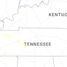
Tennessee
| Local Time | Report Details |
|---|---|
| 4:02 PM CDT | East mitchell street in trimble is closed due to a downed tree and electrical lines blocking the roadway. time is radar estimate in dyer county TN, 37.8 miles W of Mc Kenzie, TN |
| 4:11 PM CDT | Downed electric lines has been reported in the nora drive / edward street area of newbern. time is radar estimate in dyer county TN, 42 miles W of Mc Kenzie, TN |
| 5:00 PM CDT | Tree and minor building damage reported in downtown sharo in weakley county TN, 18.1 miles WNW of Mc Kenzie, TN |
| 6:05 PM CDT | Relayed via #tspotter: tree down in depriest cemeter in perry county TN, 48.1 miles SE of Mc Kenzie, TN |
| 7:58 PM CDT | Tree down on railroad bed pike... blocking the eastbound lane. time is the time of the repor in lawrence county TN, 48.5 miles NNE of Florence, AL |
Kentucky
| Local Time | Report Details |
|---|---|
| 4:04 PM CDT | Quarter sized hail reported near Madisonville, KY, 39.3 miles SSE of Evansville, IN, report from mping: quarter (1.00 in.). |
North Carolina
| Local Time | Report Details |
|---|---|
| 5:33 PM EDT | Tree down on roadwa in sampson county NC, 50 miles NNW of Wilmington, NC |
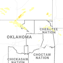
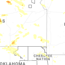
Oklahoma
| Local Time | Report Details |
|---|---|
| 4:40 PM CDT | Campers flipped over at indigo sky casino and resort just west of the missouri state line. dime size hail also reported. time estimated from rada in ottawa county OK, 74.8 miles SE of Chanute, KS |
| 5:15 PM CDT | Hen Egg sized hail reported near Big Cabin, OK, 50.8 miles ENE of Tulsa, OK, info relayed by broadcast media of multiple golf ball to 2 inch diameter measured hailstones. time estimated from radar. |
| 5:57 PM CDT | Quarter sized hail reported near Medford, OK, 59.8 miles SSW of Wichita, KS, quarter sized hail medford 7ene. |
| 7:20 PM CDT | Large tree branches snapped in blackwell. also power poles reported down south of blackwell. time is estimate in kay county OK, 61.2 miles S of Wichita, KS |
| 7:20 PM CDT | Numerous power poles downed along us-177 south of hubbard road. time is estimate in kay county OK, 64.7 miles S of Wichita, KS |
| 7:25 PM CDT | Report relayed via broadcast medi in delaware county OK, 68.5 miles N of Fort Smith, AR |
| 7:28 PM CDT | Golf Ball sized hail reported near Blackwell, OK, 60.6 miles S of Wichita, KS, golf ball sized hail reported in blackwell. |
| 7:30 PM CDT | Quarter sized hail reported near Blackwell, OK, 61.9 miles S of Wichita, KS, report from mping: quarter (1.00 in.). |
| 7:42 PM CDT | 52 knot wind gust at kpn in kay county OK, 67.3 miles S of Wichita, KS |
| 7:52 PM CDT | 59 mph wind gust at blackwel in kay county OK, 61.2 miles S of Wichita, KS |
| 7:57 PM CDT | Tree and power pole damage in newkir in kay county OK, 57.2 miles SSE of Wichita, KS |
| 8:15 PM CDT | Storm damage reported in osage county OK, 56.4 miles NW of Tulsa, OK |
| 8:45 PM CDT | Report relayed via broadcast medi in osage county OK, 41.4 miles WNW of Tulsa, OK |
| 9:35 PM CDT | Multiple reports of trees and power lines down in newkirk. time estimate in kay county OK, 57.8 miles SSE of Wichita, KS |
| 9:45 PM CDT | Newkirk mesone in kay county OK, 59.1 miles SSE of Wichita, KS |
| 9:50 PM CDT | Newkirk mesone in kay county OK, 59.1 miles SSE of Wichita, KS |
| 9:50 PM CDT | Emergency management reports roof and structure damage in lamon in grant county OK, 69.9 miles S of Wichita, KS |
| 10:03 PM CDT | Quarter sized hail reported near Ponca City, OK, 66.5 miles SSE of Wichita, KS, report from mping: quarter (1.00 in.). |
| 10:41 PM CDT | Large limbs dow in pawnee county OK, 47.3 miles WNW of Tulsa, OK |
| 11:13 PM CDT | Reported by emergency management on the west side of cushin in payne county OK, 44.8 miles WSW of Tulsa, OK |
| 11:17 PM CDT | Storm damage reported in creek county OK, 33.2 miles W of Tulsa, OK |
| 12:00 AM CDT | Storm damage reported in payne county OK, 51.6 miles NNE of Oklahoma City, OK |
| 1:20 AM CDT | Downed power pole. small wind blown tree debris found further west as well. time estimated by seminole mesonet (50 mph gust in pottawatomie county OK, 30.8 miles ESE of Oklahoma City, OK |
Utah
| Local Time | Report Details |
|---|---|
| 4:42 PM MDT | Four power poles reported down along w 2200 n per social media resulting in power outages. time estimated via radar and a 53mph gust to the east of this locatio in iron county UT, 65.6 miles SW of Monroe, UT |
Texas
| Local Time | Report Details |
|---|---|
| 8:30 PM CDT | Severe gusts lasted 4 minute. peak gust occurred at 8:31 pm cd in hemphill county TX, 77.6 miles SW of Woodward, OK |
| 9:37 PM CDT | Severe winds lasted 5 minutes with peak gust occurring at 939 pm cd in potter county TX, 15.6 miles NNW of Amarillo, TX |
| 9:55 PM CDT | Trained spotter measured winds between 60 to 65 mph with a hand held anemomete in potter county TX, 2.6 miles ENE of Amarillo, TX |
| 10:09 PM CDT | Mesonet measured gusts between 65 and 69 mph between 2209cdt and 2212cd in hemphill county TX, 77.6 miles SW of Woodward, OK |
| 11:20 PM CDT | Storm damage reported in collingsworth county TX, 25.1 miles N of Childress, TX |
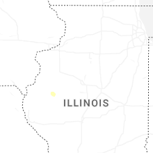
Illinois
| Local Time | Report Details |
|---|---|
| 12:23 AM CDT | Several trees and large tree limbs downed in calumet city... particularly near burnham avenue between 154th and 158th streets. a few trees fell onto homes and power lin in cook county IL, 19.5 miles SSE of Chicago, IL |
Connect with Interactive Hail Maps