

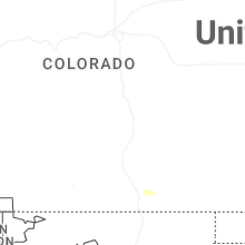
Hail Map for Wednesday, May 20, 2026

Number of Impacted Households on 5/20/2026
0
Impacted by 1" or Larger Hail
0
Impacted by 1.75" or Larger Hail
0
Impacted by 2.5" or Larger Hail
Square Miles of Populated Area Impacted on 5/20/2026
0
Impacted by 1" or Larger Hail
0
Impacted by 1.75" or Larger Hail
0
Impacted by 2.5" or Larger Hail
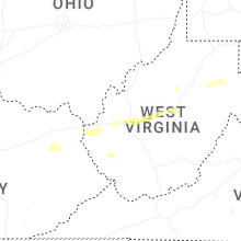
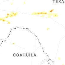
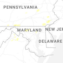
Cities Most Affected by Hail Storms of 5/20/2026
| Hail Size | Demographics of Zip Codes Affected | ||||||
|---|---|---|---|---|---|---|---|
| City | Count | Average | Largest | Pop Density | House Value | Income | Age |
| Clendenin, WV | 1 | 1.75 | 1.75 | 30 | $66k | $28.2k | 43.2 |
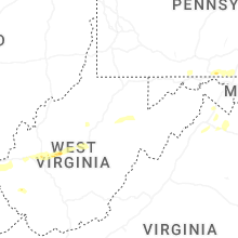
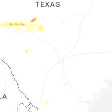
Hail and Wind Damage Spotted on 5/20/2026
Filter by Report Type:Hail ReportsWind Reports
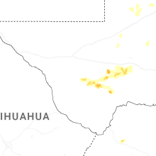
States Impacted
Texas, Maryland, Pennsylvania, Virginia, Kentucky, West Virginia, New York, New Jersey, Tennessee, AlabamaTexas
| Local Time | Report Details |
|---|---|
| 7:26 AM CDT | Port isabel-cameron country airport measured a wind gust of 64 mph associated with a thunderstorm at 7:26 a in cameron county TX, 20.4 miles NNE of Brownsville, TX |
| 3:20 PM CDT | Ping Pong Ball sized hail reported near Alpine, TX, 3.7 miles NNW of Alpine, TX, a member of the public sent a picture of a large hailstone (approximately ping-pong ball size) near alpine. the time of occurrence and exact location are estimated from |
| 4:58 PM CDT | Quarter sized hail reported near , , 48 miles ENE of Alpine, TX, emergency manager reported quarter-sized hail 16 miles south of fort stockton on us 385. |
| 5:00 PM CDT | Quarter sized hail reported near , , 47.7 miles ENE of Alpine, TX, received a report of dime to quarter-sized hail about 15-20 miles south of fort stockton. the time of occurrence is partially estimated from radar. |
| 5:48 PM CDT | Quarter sized hail reported near , , 62.4 miles ENE of Alpine, TX, emergency manager reported quarter-sized hail 21-23 miles south/southeast of fort stockton along us 285. |
Maryland
| Local Time | Report Details |
|---|---|
| 1:25 PM EDT | Trees blew down on md-144 national pike northeast at frank davis roa in allegany county MD, 83.3 miles SSW of State College, PA |
| 3:11 PM EDT | Trees blew down on us-15 at mountville roa in frederick county MD, 48.4 miles W of Baltimore, MD |
| 3:18 PM EDT | Trees blew down on us-15 at md-464 point of rocks roa in frederick county MD, 49.3 miles W of Baltimore, MD |
| 3:19 PM EDT | Multiple trees down on monocacy blvd near south market driv in frederick county MD, 43.5 miles W of Baltimore, MD |
| 3:42 PM EDT | Numerous powerlines down on the 3000 block of buckeystown pik in frederick county MD, 44.5 miles WNW of Baltimore, MD |
| 3:45 PM EDT | Several large tree branches snapped and a flagpole bent along coppermine road in union bridg in frederick county MD, 37.5 miles WNW of Baltimore, MD |
| 3:46 PM EDT | Trees and wires blew down on md-94 woodbine road at old annapolis roa in howard county MD, 26.4 miles W of Baltimore, MD |
| 4:05 PM EDT | Power poles were down around new windso in carroll county MD, 31.8 miles WNW of Baltimore, MD |
| 4:25 PM EDT | Trees blew down on md-45 york road near i-8 in baltimore county MD, 25.6 miles N of Baltimore, MD |
| 4:27 PM EDT | Multiple trees down including one that impacted a house and a car in northwest baltimor in baltimore city county MD, 5.9 miles NW of Baltimore, MD |
| 4:30 PM EDT | Several trees blew down in eastern howard county in ellicott city... scaggsville... ilchester... and columbia... including one onto a car on scarecrow court in columbia in howard county MD, 9.8 miles WSW of Baltimore, MD |
| 4:34 PM EDT | Wind gusts of up to 57 knots (66 mph) were measured by a personal weather station in downtown baltimore (kmdbalti493) adjacent to the tidal patapsco river between 4:34 in baltimore city county MD, 1.8 miles SE of Baltimore, MD |
| 4:39 PM EDT | A wind gust of 57 knots (66 mph) was measured by a personal weather station in downtown baltimore (kmdbalti493). several trees blew down throughout the cit in baltimore city county MD, 1.8 miles SE of Baltimore, MD |
| 4:54 PM EDT | Trees blew down on md-543 ady road at smithson driv in harford county MD, 26.6 miles NE of Baltimore, MD |
| 5:25 PM EDT | There were several trees and large tree limbs blown down around conowing in cecil county MD, 36 miles NE of Baltimore, MD |
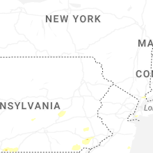
Pennsylvania
| Local Time | Report Details |
|---|---|
| 1:35 PM EDT | Multiple reports of wires down along welsh run road and mercersburg roa in franklin county PA, 71.3 miles S of State College, PA |
| 1:43 PM EDT | Wires down reported in upton along lemar road and buchanan trail wes in franklin county PA, 67.9 miles S of State College, PA |
| 1:48 PM EDT | Report of large trees down on grant shook road between filer road and worleytown roa in franklin county PA, 70.1 miles WNW of Baltimore, MD |
| 3:05 PM EDT | Multiple reports of trees and wires down in hanover boroug in york county PA, 40.3 miles NNW of Baltimore, MD |
| 3:35 PM EDT | Roof blown off a barn and multiple trees and wires down on prescott road between birch road and fox road in south lebanon townshi in lebanon county PA, 73 miles N of Baltimore, MD |
| 3:38 PM EDT | Multiple trees down with cars stuck on the road on gold mine roa in schuylkill county PA, 71.7 miles ESE of State College, PA |
| 3:46 PM EDT | Multiple reports of trees and wires down around red lio in york county PA, 42 miles N of Baltimore, MD |
| 3:53 PM EDT | Trees and wires down on rohrerstown road in east hempfield townshi in lancaster county PA, 53.4 miles NNE of Baltimore, MD |
| 3:54 PM EDT | Tree down on schuykil mountain roa in schuylkill county PA, 61.8 miles SSW of Scranton, PA |
| 3:56 PM EDT | Large tree down on two vehicles. blocking the intersection of janet avenue / fountain avenue in manheim township. also brought power lines down. multiple other reports in lancaster county PA, 55.7 miles NNE of Baltimore, MD |
| 3:56 PM EDT | Tree down on house. telephone poll snapped and wires down in the 500 block of bull run rd. wires started a fire. road is close in york county PA, 45.9 miles N of Baltimore, MD |
| 3:57 PM EDT | Report of a tree fallen onto a hom in lancaster county PA, 55.6 miles NNE of Baltimore, MD |
| 4:02 PM EDT | Trees and wires down on long level rd in lower windsor townshi in york county PA, 47.3 miles N of Baltimore, MD |
| 4:07 PM EDT | Trees down on wires near mountain drive/pine grove road in bethel townshi in lebanon county PA, 75.5 miles SSW of Scranton, PA |
| 4:10 PM EDT | Trees and wires down around bethel/fredericksburg. time estimated from rada in berks county PA, 75.6 miles SSW of Scranton, PA |
| 4:14 PM EDT | Tree down into a house. time estimated from rada in berks county PA, 76 miles NNE of Baltimore, MD |
| 4:14 PM EDT | Wires down at the intersection of charlestown road and pa 74 in lancaster county PA, 52.1 miles NNE of Baltimore, MD |
| 4:15 PM EDT | Trees down on wires along mount penn road. time estimated from rada in berks county PA, 76.6 miles NNE of Baltimore, MD |
| 4:15 PM EDT | Wires down on state street in hamburg... pa. time estimated from rada in berks county PA, 61.9 miles SSW of Scranton, PA |
| 4:27 PM EDT | Tree down blocking the road along moselem spring road. time estimated from rada in berks county PA, 63.8 miles S of Scranton, PA |
| 4:30 PM EDT | Trees down on wires. time estimated from rada in berks county PA, 79.1 miles S of Scranton, PA |
| 4:33 PM EDT | Tree down on wires along eagle point road in maxatawny township. time estimated from rada in berks county PA, 60.3 miles S of Scranton, PA |
| 4:35 PM EDT | Multiple reports of trees and wires dow in lancaster county PA, 56.6 miles NNE of Baltimore, MD |
| 4:41 PM EDT | Wires down. near intersection of snake ln & old philadelphia pik in lancaster county PA, 60.2 miles NNE of Baltimore, MD |
| 4:47 PM EDT | Several large trees down and trees down on power wires on hanover street. trees down on wires on manatawny st. and spring st. time approximate from kdix rada in chester county PA, 81.4 miles S of Scranton, PA |
| 4:47 PM EDT | Several trees and large tree limbs down on charlotte street and diamond street. time estimated from kdix rada in montgomery county PA, 79.4 miles S of Scranton, PA |
| 4:47 PM EDT | Wires down along sunset drive. time estimated from rada in berks county PA, 76.6 miles S of Scranton, PA |
| 4:48 PM EDT | Picture sent in via social media of multiple trees down. time estimated from rada in montgomery county PA, 80.1 miles S of Scranton, PA |
| 4:50 PM EDT | Trees and wires down in east greenville. time estimated from rada in montgomery county PA, 69.5 miles S of Scranton, PA |
| 4:59 PM EDT | Trees down around limerick... pa. time estimated from rada in montgomery county PA, 81.7 miles S of Scranton, PA |
| 4:59 PM EDT | Downed utility on beverly hills rd / churchview rd both directions between limeport pk and lamour st. all lanes now open. time estimated from rada in lehigh county PA, 63.1 miles S of Scranton, PA |
| 5:01 PM EDT | Trees and wires down around east coventry township... pa. time estimated from rada in chester county PA, 81.9 miles NE of Baltimore, MD |
| 5:03 PM EDT | Widespread trees and wires down in new hanover township... pa. time estimated from rada in montgomery county PA, 76.1 miles S of Scranton, PA |
| 5:12 PM EDT | Picture sent in of a large pine tree down. time estimated from rada in chester county PA, 68.8 miles NE of Baltimore, MD |
| 5:16 PM EDT | Downed tree on bridge st / charlestown rd southbound between swiss ln and hollow rd. there is a traffic disruption. time estimated from rada in chester county PA, 79.8 miles NE of Baltimore, MD |
| 5:23 PM EDT | Downed tree on pa 611 northbound between bristol rd and almshouse rd. there is a traffic disruption. time estimated from rada in bucks county PA, 66.9 miles WSW of Brooklyn, NY |
| 5:25 PM EDT | Trees and wires down around colmar. time estimated from rada in montgomery county PA, 73 miles WSW of Brooklyn, NY |
| 5:25 PM EDT | Quarter sized hail reported near Wayne, PA, 83.5 miles NE of Baltimore, MD, time estimated from radar. picture sent in from skywarn spotter. |
| 5:39 PM EDT | Trees down on route 1 across the roadway in media resulting in lane closures. time estimated from rada in delaware county PA, 73.9 miles NE of Baltimore, MD |
Virginia
| Local Time | Report Details |
|---|---|
| 2:56 PM EDT | Photo of two trees down on fort valley road near the trailhea in shenandoah county VA, 67.9 miles ESE of Elkins, WV |
| 3:00 PM EDT | Trees blew down on eastbound business-va-7 main street/east loudoun street in the vicinity of simmons roa in loudoun county VA, 62.1 miles W of Baltimore, MD |
| 3:00 PM EDT | Trees blew down on eastbound va-725 paxson road in the vicinity of va-719 airmont roa in loudoun county VA, 64.2 miles WSW of Baltimore, MD |
| 3:02 PM EDT | Trees blew down on paxson road just west of va-690 silcott springs roa in loudoun county VA, 62.1 miles WSW of Baltimore, MD |
| 3:05 PM EDT | Two trees were down around the 800 block of downing farm roa in warren county VA, 84.9 miles E of Elkins, WV |
| 3:13 PM EDT | Large tree limbs blew down along us-15 near sugarloaf view lan in loudoun county VA, 49.5 miles W of Baltimore, MD |
| 3:32 PM EDT | Tree down on the 3000 block of senseny r in clarke county VA, 77.5 miles W of Baltimore, MD |
| 3:42 PM EDT | Numerous trees down on cherry hill road and fiery run roa in fauquier county VA, 82.5 miles WSW of Baltimore, MD |
| 3:45 PM EDT | Spotter reported downed trees and large limbs near buck mountain road and link evans roa in albemarle county VA, 64.1 miles NW of Richmond, VA |
| 7:45 PM UTC | Spotter reported multiple trees down near buck mountain road and markwood/simmons gap road in albemarle county VA, 66.6 miles NW of Richmond, VA |
| 3:47 PM EDT | Half-mile section along the 9300 block of us-50 john mosby highway closed due to power lines and power poles down from thunderstorm wind gus in fauquier county VA, 72.2 miles WSW of Baltimore, MD |
| 4:09 PM EDT | Tree down on catesby farm lan in loudoun county VA, 68 miles WSW of Baltimore, MD |
| 6:00 PM EDT | Scoreboard at cave spring middle school blown down by thunderstorm winds. report via social medi in roanoke county VA, 6.1 miles SW of Roanoke, VA |
| 6:33 PM EDT | Tree downed by thunderstorm winds near the intersection of beagle club road and hardy roa in bedford county VA, 5.6 miles E of Roanoke, VA |
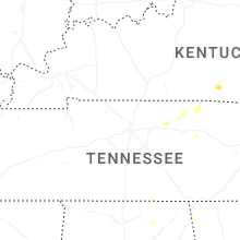
Kentucky
| Local Time | Report Details |
|---|---|
| 3:40 PM EDT | Tree down blocking part of main stree in carter county KY, 70.8 miles NE of Irvine, KY |
West Virginia
| Local Time | Report Details |
|---|---|
| 3:52 PM EDT | Tree fell on an unoccupied vehicl in cabell county WV, 35.6 miles W of Charleston, WV |
| 3:59 PM EDT | Tree down on power lines and on fir in wayne county WV, 49.3 miles W of Charleston, WV |
| 4:05 PM EDT | Quarter sized hail reported near Poca, WV, 12.4 miles NW of Charleston, WV, report from mping: quarter (1.00 in.). |
| 4:08 PM EDT | Quarter sized hail reported near Poca, WV, 12.9 miles NW of Charleston, WV, reports of nickel to quarter size hail. |
| 4:09 PM EDT | Tree dow in wayne county WV, 52.9 miles W of Charleston, WV |
| 4:10 PM EDT | Power lines down along poca river road. time estimated from rada in putnam county WV, 10.9 miles NW of Charleston, WV |
| 4:26 PM EDT | Tree down with photo on social medi in wayne county WV, 44.3 miles W of Charleston, WV |
| 4:29 PM EDT | Tree dow in kanawha county WV, 3.8 miles ESE of Charleston, WV |
| 4:42 PM EDT | Half Dollar sized hail reported near Charleston, WV, 9 miles N of Charleston, WV, report from mping: half dollar (1.25 in.). |
| 4:45 PM EDT | Quarter sized hail reported near Charleston, WV, 11.7 miles N of Charleston, WV, social media video showing quarter size hail. |
| 5:03 PM EDT | Trees down at intersection of reamer road and youngstown driv in kanawha county WV, 16.3 miles ENE of Charleston, WV |
| 5:04 PM EDT | Tree down along elk river roa in kanawha county WV, 16.7 miles ENE of Charleston, WV |
| 5:06 PM EDT | Golf Ball sized hail reported near Clendenin, WV, 18.4 miles ENE of Charleston, WV, verified through social media picture. |
| 5:11 PM EDT | Tree down along 119. picture on social medi in kanawha county WV, 18.4 miles ENE of Charleston, WV |
| 5:13 PM EDT | Tree down along thorofare. power out in the are in kanawha county WV, 21.3 miles ENE of Charleston, WV |
| 5:18 PM EDT | Half Dollar sized hail reported near Clendenin, WV, 21.2 miles ENE of Charleston, WV |
| 5:30 PM EDT | Quarter sized hail reported near Chapmanville, WV, 32.9 miles SW of Charleston, WV, photo verified through social media. |
| 5:40 PM EDT | Tree down on wallback road. time estimated by rada in clay county WV, 29.5 miles ENE of Charleston, WV |
| 6:30 PM EDT | Trees dow in braxton county WV, 45.4 miles WSW of Elkins, WV |
| 8:04 PM EDT | Storm damage reported in randolph county WV, 2.5 miles W of Elkins, WV |
| 8:14 PM EDT | Multiple trees and power lines dow in barbour county WV, 14.6 miles NNW of Elkins, WV |
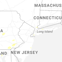
New York
| Local Time | Report Details |
|---|---|
| 4:42 PM EDT | Tree and branches down on soundview avenue in east northport with time of report estimated by rada in suffolk county NY, 37.7 miles ENE of Brooklyn, NY |
| 5:30 PM EDT | Tree down on i-684 near saw mill river parkway exi in westchester county NY, 41.8 miles NNE of Brooklyn, NY |
| 5:30 PM EDT | Wires reported down on jay street and beaver dam road in katona in westchester county NY, 42.6 miles NNE of Brooklyn, NY |
| 5:40 PM EDT | Downed tree on ny 25a at hastings drive in smithtown with all lanes closed both direction in suffolk county NY, 39.4 miles ENE of Brooklyn, NY |
| 6:39 PM EDT | Tree reported branches dow in kings county NY, 5.8 miles S of Brooklyn, NY |
| 7:10 PM EDT | Tree down on shore road and 97th stree in kings county NY, 5.2 miles SSW of Brooklyn, NY |
New Jersey
| Local Time | Report Details |
|---|---|
| 5:57 PM EDT | Several trees and wires down around hopewell. time estimated from rada in mercer county NJ, 45.1 miles WSW of Brooklyn, NY |
| 6:05 PM EDT | Wires down in hainesport along marne highway... likely due to outflow boundary. time estimated from rada in burlington county NJ, 65.8 miles SW of Brooklyn, NY |
| 6:06 PM EDT | Several wires down across bordentown and chesterfield. time estimated from rada in burlington county NJ, 53.8 miles SW of Brooklyn, NY |
| 6:10 PM EDT | Wires down along taunton road and himmelein road in medford... likely due to the outflow boundary. time estimated from rada in burlington county NJ, 71.5 miles SW of Brooklyn, NY |
| 6:11 PM EDT | Social media image of a large tree limb down. time approximate from kdix rada in middlesex county NJ, 26.3 miles WSW of Brooklyn, NY |
| 6:27 PM EDT | Weather station on doc in monmouth county NJ, 20.6 miles SSW of Brooklyn, NY |
| 6:30 PM EDT | Social media images of several large tree limbs down as well as some trees across edison and metuchen. time approximate from kdix rada in middlesex county NJ, 23.4 miles WSW of Brooklyn, NY |
| 6:45 PM EDT | Wires down and snapped telephone poles on plum lane in holmdel n in monmouth county NJ, 20.6 miles SSW of Brooklyn, NY |
| 6:53 PM EDT | Large tree down blocking the road. time approximate from kdix rada in monmouth county NJ, 19 miles S of Brooklyn, NY |
| 6:53 PM EDT | Transformer exploded. several large poles down on seacrest rd. time approximate from kdix rada in monmouth county NJ, 25 miles S of Brooklyn, NY |
Tennessee
| Local Time | Report Details |
|---|---|
| 6:46 PM EDT | Tree down blocking entire roa in knox county TN, 0.7 miles S of Knoxville, TN |
| 6:47 PM EDT | Tree partially blocking the east bound lane in knox county TN, 7.7 miles NNE of Knoxville, TN |
| 6:51 PM EDT | Powerlines partially down over roadwa in knox county TN, 8.9 miles ENE of Knoxville, TN |
| 6:55 PM EDT | Tree partially blocking lan in knox county TN, 5.6 miles S of Knoxville, TN |
| 7:02 PM EDT | Tree hanging over the road in power line in knox county TN, 5 miles SSW of Knoxville, TN |
| 7:08 PM EDT | Tree blocking entire roa in knox county TN, 0.7 miles S of Knoxville, TN |
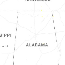
Alabama
| Local Time | Report Details |
|---|---|
| 7:27 PM CDT | Tree limbs were knocked down onto power lines at 2657 al highway 65. time estimated by rada in jackson county AL, 61.7 miles WSW of Chattanooga, TN |
Connect with Interactive Hail Maps