

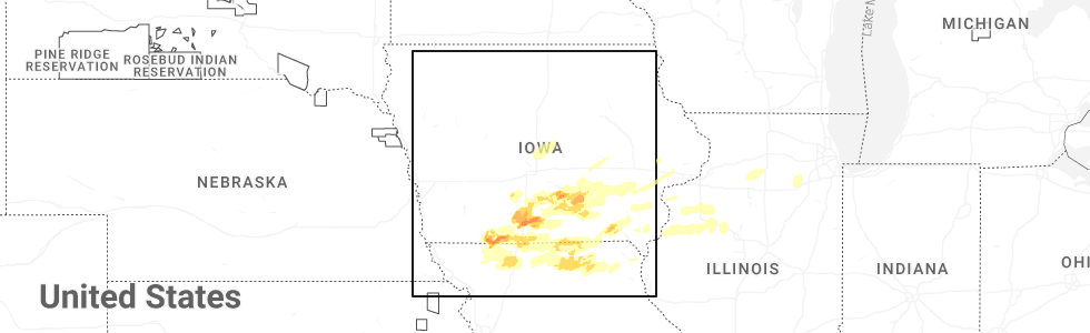
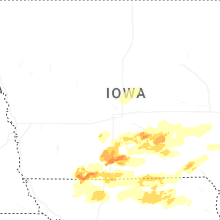
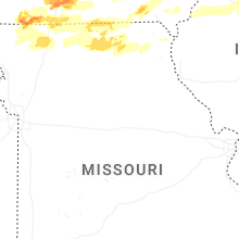
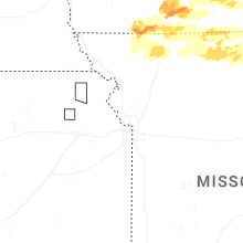
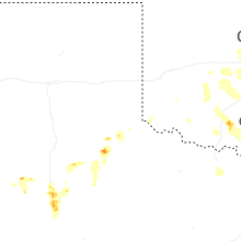
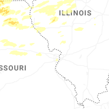
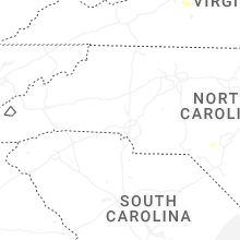
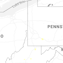
Hail Map for Thursday, June 11, 2026
Number of Impacted Households on 6/11/2026
0
Impacted by 1" or Larger Hail
0
Impacted by 1.75" or Larger Hail
0
Impacted by 2.5" or Larger Hail
Square Miles of Populated Area Impacted on 6/11/2026
0
Impacted by 1" or Larger Hail
0
Impacted by 1.75" or Larger Hail
0
Impacted by 2.5" or Larger Hail
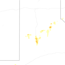

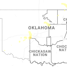

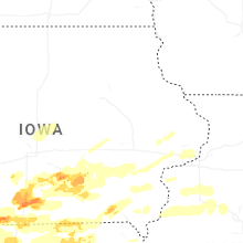
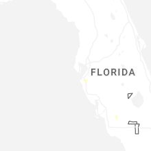
Cities Most Affected by Hail Storms of 6/11/2026
| Hail Size | Demographics of Zip Codes Affected | ||||||
|---|---|---|---|---|---|---|---|
| City | Count | Average | Largest | Pop Density | House Value | Income | Age |
| Knoxville, IA | 3 | 1.75 | 1.75 | 67 | $75k | $38.9k | 41.3 |
| El Reno, OK | 2 | 2.13 | 2.50 | 96 | $60k | $32.2k | 34.9 |
| Bussey, IA | 2 | 1.88 | 2.00 | 15 | $50k | $33.4k | 43.3 |
| Appleton City, MO | 2 | 1.88 | 2.00 | 14 | $51k | $27.5k | 46.1 |
| Grant City, MO | 1 | 2.00 | 2.00 | 7 | $31k | $28.8k | 48.2 |
| Osceola, IA | 1 | 1.75 | 1.75 | 34 | $70k | $33.8k | 39.4 |
| Toluca, IL | 1 | 1.75 | 1.75 | 15 | $62k | $39.2k | 44.9 |
| Tracy, IA | 1 | 1.75 | 1.75 | 13 | $49k | $37.1k | 40.5 |
| Union City, OK | 1 | 1.75 | 1.75 | 14 | $61k | $35.4k | 38.4 |
Hail and Wind Damage Spotted on 6/11/2026
Filter by Report Type:Hail ReportsWind Reports
States Impacted
Iowa, Missouri, Illinois, Minnesota, Wisconsin, Ohio, Pennsylvania, West Virginia, New York, Connecticut, Texas, Maryland, North Carolina, Kansas, Virginia, Oklahoma, District of Columbia, Indiana, Michigan, New Jersey, ArkansasIowa
| Local Time | Report Details |
|---|---|
| 7:02 AM CDT | Golf Ball sized hail reported near Knoxville, IA, 38.8 miles SE of Des Moines, IA, pershing iowa. |
| 7:10 AM CDT | Report of tree down. time estimated by rada in clarke county IA, 37.7 miles SSW of Des Moines, IA |
| 7:15 AM CDT | Est time - larger tree top damage greater than 12 in diameter and sign damag in dallas county IA, 22 miles WNW of Des Moines, IA |
| 7:15 AM CDT | Quarter sized hail reported near Knoxville, IA, 31.8 miles SE of Des Moines, IA |
| 7:15 AM CDT | Received report of small tree down in perry. time estimated from rada in dallas county IA, 30.4 miles NW of Des Moines, IA |
| 7:20 AM CDT | Golf Ball sized hail reported near Osceola, IA, 39 miles SSW of Des Moines, IA, report of ping pong to golf ball sized hail relayed from media. time estimated from radar. |
| 7:22 AM CDT | Delayed report. received photo via email of tree damage in saint charle in madison county IA, 23 miles SSW of Des Moines, IA |
| 7:25 AM CDT | Received report of tree down blocking ia-141. time estimated from rada in polk county IA, 12 miles NW of Des Moines, IA |
| 7:30 AM CDT | Received report via email of 6 inch tree limbs down. time estimated from rada in polk county IA, 6.9 miles N of Des Moines, IA |
| 7:36 AM CDT | Time estimated via rada in lucas county IA, 41.5 miles SSE of Des Moines, IA |
| 7:39 AM CDT | Healthy medium size sugar maple tree snapped from the roots. time estimated via rada in polk county IA, 8.2 miles ENE of Des Moines, IA |
| 7:45 AM CDT | Delayed report - time estimated from radar. photo via social media of damage to buildin in monroe county IA, 51.4 miles SE of Des Moines, IA |
| 7:49 AM CDT | Delayed entry - measured from klw in decatur county IA, 67.9 miles SSW of Des Moines, IA |
| 7:53 AM CDT | Delayed entry - measured from kam in story county IA, 27.6 miles N of Des Moines, IA |
| 7:55 AM CDT | Quarter sized hail reported near Knoxville, IA, 33.8 miles SE of Des Moines, IA, time estimated from radar. |
| 7:57 AM CDT | Storm damage reported in marion county IA, 33 miles SE of Des Moines, IA |
| 7:58 AM CDT | Golf Ball sized hail reported near Knoxville, IA, 32.6 miles SE of Des Moines, IA, report relayed from nws chat. |
| 7:58 AM CDT | Golf Ball sized hail reported near Knoxville, IA, 32.6 miles SE of Des Moines, IA, report relayed from nws chat. |
| 7:59 AM CDT | Delayed entry - gust measured from kam in story county IA, 27.6 miles N of Des Moines, IA |
| 8:00 AM CDT | Golf Ball sized hail reported near Tracy, IA, 44.1 miles ESE of Des Moines, IA, report of golf ball sized hail relayed from broadcast media. time estimated from radar. |
| 8:00 AM CDT | Ping Pong Ball sized hail reported near Knoxville, IA, 38.8 miles SE of Des Moines, IA, delayed report - time estimated from radar. |
| 8:05 AM CDT | Hen Egg sized hail reported near Bussey, IA, 47.2 miles SE of Des Moines, IA, delayed report - time estimated by radar. relayed by broadcast media. |
| 8:05 AM CDT | Delayed report - time estimated by radar. damage to siding due to wind-driven hai in monroe county IA, 52.6 miles SE of Des Moines, IA |
| 8:05 AM CDT | Delayed report - time estimated by radar. received photos via email of tree damage in nevada... i in story county IA, 31 miles NNE of Des Moines, IA |
| 8:10 AM CDT | Quarter sized hail reported near Albia, IA, 57.4 miles SE of Des Moines, IA, delayed report - time estimated from radar. |
| 8:10 AM CDT | Quarter sized hail reported near Pella, IA, 37.2 miles ESE of Des Moines, IA, report relayed from broadcast media. time estimated from radar. |
| 8:10 AM CDT | Golf Ball sized hail reported near Bussey, IA, 46.4 miles SE of Des Moines, IA, reports of golf ball size hail relayed from media. |
| 8:12 AM CDT | Quarter sized hail reported near Albia, IA, 57.5 miles SE of Des Moines, IA, spotter gt317 in s albia near highway 34 - large amount of dime sized hail with some quarter sized mixed in. |
| 8:14 AM CDT | Quarter sized hail reported near Oskaloosa, IA, 54.2 miles ESE of Des Moines, IA |
| 8:35 AM CDT | Report of tree branches down relayed from ema. time estimated from rada in poweshiek county IA, 45.2 miles SW of Cedar Rapids, IA |
| 8:35 AM CDT | Report of shed down relayed by ema. time estimated from rada in poweshiek county IA, 45.6 miles SW of Cedar Rapids, IA |
| 8:35 AM CDT | Report of sheds down relayed from ema. time estimated by rada in mahaska county IA, 54.2 miles SW of Cedar Rapids, IA |
| 8:42 AM CDT | Delayed report - measured from kmi in marshall county IA, 50.8 miles NE of Des Moines, IA |
| 8:43 AM CDT | Law enforcement posted a picture of snapped power poles on social media. poles were on 190th street just west of dysart. delayed report... time estimated with rada in tama county IA, 36.3 miles WNW of Cedar Rapids, IA |
| 8:43 AM CDT | Corrects time of previous tstm wnd dmg report from 1 w sigourney. observed 2 large trees down lying west to east on the south side of sigourney on our way back into tow in keokuk county IA, 52.2 miles SSW of Cedar Rapids, IA |
| 8:50 AM CDT | Snapped trees took out a power line. time estimated from rada in benton county IA, 26.5 miles WNW of Cedar Rapids, IA |
| 8:51 AM CDT | Pictures sent in from em of limbs and branches down. minor damage to a pavilion at the city park. time estimated via rada in poweshiek county IA, 41.1 miles WSW of Cedar Rapids, IA |
| 9:38 AM CDT | Delayed report - measured at kalo aso in black hawk county IA, 54.9 miles NW of Cedar Rapids, IA |
| 9:43 AM CDT | Observed 2 large trees down lying west to east on the south side of sigourney on our way back into town... along with several tree limb in keokuk county IA, 52.2 miles SSW of Cedar Rapids, IA |
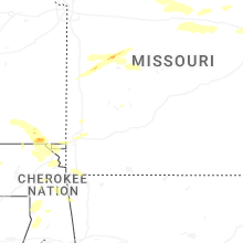
Missouri
| Local Time | Report Details |
|---|---|
| 7:20 AM CDT | Hen Egg sized hail reported near Grant City, MO, 90 miles SSW of Des Moines, IA, report relayed from social media. time estimated from radar. |
| 8:15 AM CDT | Estimated 60 to 65 mph gusts in merce in mercer county MO, 74.6 miles S of Des Moines, IA |
| 8:25 AM CDT | Ping Pong Ball sized hail reported near Bethany, MO, 83.9 miles NNE of Kansas City, MO, ping pong ball sized hail reported at the junction of us 136 and us 69. |
| 8:26 AM CDT | Quarter sized hail reported near Bethany, MO, 85.1 miles NNE of Kansas City, MO, quarter sized hail reported in bethany. |
| 8:31 AM CDT | Quarter sized hail reported near Bethany, MO, 84.4 miles NNE of Kansas City, MO, report relayed by em. time estimated from radar. |
| 4:20 PM CDT | Several large tree limbs dow in clark county MO, 0.6 miles W of Kahoka, MO |
| 5:51 PM CDT | Quarter sized hail reported near Clinton, MO, 70.8 miles SE of Kansas City, MO, quarter-sized hail reported by spotters. report relayed by em. |
| 8:22 PM CDT | Hen Egg sized hail reported near Appleton City, MO, 69.5 miles SSE of Kansas City, MO |
| 8:33 PM CDT | Golf Ball sized hail reported near Appleton City, MO, 69 miles SSE of Kansas City, MO, report relayed by em. |
| 8:36 PM CDT | Quarter sized hail reported near Clinton, MO, 68.5 miles SE of Kansas City, MO, report relayed via social media. time estimated from radar. |
| 9:44 PM CDT | Report of a tree down on highway 59 past two sons campgroun in mcdonald county MO, 79.1 miles SW of Springfield, MO |
Illinois
| Local Time | Report Details |
|---|---|
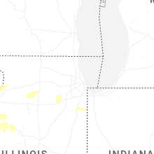
| 10:09 AM CDT | A few larger branches downed... including one that downed a power line. time estimate in rock island county IL, 70.6 miles ESE of Cedar Rapids, IA |
| 3:54 PM CDT | Quarter sized hail reported near Carthage, IL, 25.3 miles E of Kahoka, MO |
| 5:15 PM CDT | Large tree limb blown down onto powerlines and the road. time estimated by rada in tazewell county IL, 9.4 miles E of Peoria, IL |
| 5:25 PM CDT | Golf Ball sized hail reported near Toluca, IL, 33 miles NE of Peoria, IL |
| 5:34 PM CDT | Peak gust measured on personal weather statio in winnebago county IL, 53.5 miles S of Madison, WI |
| 5:40 PM CDT | Storm damage reported in fulton county IL, 36.2 miles WSW of Peoria, IL |
| 5:45 PM CDT | Several power poles snapped along dickson mounds road. time estimated by rada in fulton county IL, 34.1 miles SW of Peoria, IL |
| 5:45 PM CDT | Three inch tree limb blown dow in fulton county IL, 30.5 miles WSW of Peoria, IL |
| 5:47 PM CDT | Multiple large tree branches were blown down. time estimated by rada in peoria county IL, 14.4 miles SW of Peoria, IL |
| 5:48 PM CDT | Storm damage reported in fulton county IL, 36.2 miles WSW of Peoria, IL |
| 5:50 PM CDT | 18 inch diameter tree blown dow in peoria county IL, 18.5 miles WSW of Peoria, IL |
| 5:55 PM CDT | Quarter sized hail reported near Glasford, IL, 18.6 miles SW of Peoria, IL, report from mping: quarter (1.00 in.). |
| 6:00 PM CDT | 14 inch diameter tree blown dow in peoria county IL, 4.4 miles SW of Peoria, IL |
| 6:00 PM CDT | Large branches broken near fleming road and thompson road. time estimated by rada in mchenry county IL, 50.5 miles NW of Chicago, IL |
| 6:01 PM CDT | Tree limbs blown down. time estimated by rada in tazewell county IL, 8.9 miles SSW of Peoria, IL |
| 6:03 PM CDT | Tree limbs blown down... approximately 2 to 6 inches in diameter. time estimate by rada in peoria county IL, 1.3 miles WNW of Peoria, IL |
| 6:03 PM CDT | Six inch diameter tree limb blown dow in tazewell county IL, 13.8 miles SSW of Peoria, IL |
| 6:04 PM CDT | Tree limbs blown down... four to six inches in diameter. time estimated by rada in peoria county IL, 2.6 miles NW of Peoria, IL |
| 6:05 PM CDT | Trees down in havan in mason county IL, 36.8 miles SW of Peoria, IL |
| 6:05 PM CDT | Quarter sized hail reported near Mapleton, IL, 7.7 miles SW of Peoria, IL, report from mping: quarter (1.00 in.). |
| 6:05 PM CDT | Trees and power lines down on 2nd and 3rd stree in tazewell county IL, 12.5 miles SSW of Peoria, IL |
| 6:06 PM CDT | Storm damage reported in peoria county IL, 5.8 miles WSW of Peoria, IL |
| 6:08 PM CDT | Power poles snapped. time estimated by rada in tazewell county IL, 7.7 miles SSE of Peoria, IL |
| 6:11 PM CDT | Tree blown down onto power lines and roadway. time estimate by rada in tazewell county IL, 3.6 miles S of Peoria, IL |
| 6:11 PM CDT | Tree down on roadway. time estimate by rada in tazewell county IL, 3.6 miles S of Peoria, IL |
| 6:12 PM CDT | Storm damage reported in tazewell county IL, 0.8 miles S of Peoria, IL |
| 6:12 PM CDT | Trees blown dow in tazewell county IL, 3.6 miles S of Peoria, IL |
| 6:13 PM CDT | Tree down blocking cr 1700n. time estimated by rada in tazewell county IL, 13 miles SE of Peoria, IL |
| 6:15 PM CDT | Estimated 70 mph gusts with tree damage observe in tazewell county IL, 9.2 miles SE of Peoria, IL |
| 6:15 PM CDT | Estimated 70 mph gusts with tree damage observe in tazewell county IL, 9.2 miles SE of Peoria, IL |
| 6:15 PM CDT | Trees snapped... approximately two feet in diameter. other branches blown dow in tazewell county IL, 10 miles SE of Peoria, IL |
| 6:16 PM CDT | Storm damage reported in tazewell county IL, 8.9 miles SE of Peoria, IL |
| 6:17 PM CDT | Semi-truck blown over... multiple vehicle in ditch. possible tornado. time estimated by rada in tazewell county IL, 13 miles ESE of Peoria, IL |
| 6:17 PM CDT | Time estimated by rada in tazewell county IL, 16.4 miles SE of Peoria, IL |
| 6:17 PM CDT | Social media photo showing a large tree blown down onto a chain link fence. time estimated by rada in tazewell county IL, 14.7 miles ESE of Peoria, IL |
| 6:20 PM CDT | A large branch was blown down onto a power lin in tazewell county IL, 22.4 miles S of Peoria, IL |
| 6:20 PM CDT | Large tree branches blown down... brick sign and courtyard umbrella damaged. time estimated by rada in tazewell county IL, 9.6 miles SE of Peoria, IL |
| 6:21 PM CDT | Storm damage reported in tazewell county IL, 6.8 miles E of Peoria, IL |
| 6:22 PM CDT | Storm damage reported in tazewell county IL, 13.2 miles E of Peoria, IL |
| 6:24 PM CDT | Large tree down just west of mason city near route 10 and route 29. tree is approximately two feet in diamete in mason county IL, 34.7 miles SSW of Peoria, IL |
| 6:24 PM CDT | Personal weather statio in woodford county IL, 12.4 miles NE of Peoria, IL |
| 6:24 PM CDT | Storm damage reported in mason county IL, 34.5 miles S of Peoria, IL |
| 6:24 PM CDT | Storm damage reported in mason county IL, 34.5 miles S of Peoria, IL |
| 6:24 PM CDT | Outbuilding blown over... small farm machinery blown over... large tree uprooted. time estimated by rada in woodford county IL, 18.8 miles E of Peoria, IL |
| 6:24 PM CDT | Several branches down... some one to two feet in diamete in woodford county IL, 13.7 miles ENE of Peoria, IL |
| 6:30 PM CDT | Storm damage reported in woodford county IL, 15.7 miles E of Peoria, IL |
| 6:30 PM CDT | Large tree limbs... two feet in diameter or greater... blown down onto house resulting in structural damage. time estimated by rada in mclean county IL, 25.3 miles ESE of Peoria, IL |
| 6:33 PM CDT | Grain bin destroyed south of el paso. time estimated by rada in woodford county IL, 29.8 miles E of Peoria, IL |
| 6:35 PM CDT | Multiple tree limbs blown down... one approximately six inches in diamete in mclean county IL, 33.2 miles ESE of Peoria, IL |
| 6:35 PM CDT | Large tree blown down onto powerlines. time estimated by rada in sangamon county IL, 59.4 miles SSW of Peoria, IL |
| 6:37 PM CDT | Power lines blown dow in logan county IL, 35.3 miles SSE of Peoria, IL |
| 6:39 PM CDT | A semi-truck was blown over near the i-74/i-55 interchange. time estimated by rada in mclean county IL, 34.6 miles ESE of Peoria, IL |
| 6:40 PM CDT | Social media photo showing a very large tree blown down (4 to 5 feet in diameter). time estimated by rada in mclean county IL, 33.9 miles ESE of Peoria, IL |
| 6:40 PM CDT | Large tree branch down onto a fenc in logan county IL, 38.3 miles SSE of Peoria, IL |
| 6:40 PM CDT | Downed tree took down a power line and has the road blocke in tazewell county IL, 4.1 miles SSE of Peoria, IL |
| 6:40 PM CDT | A tree was uprooted on the south side of the nws lincoln buildin in logan county IL, 39.6 miles SSE of Peoria, IL |
| 6:40 PM CDT | Power lines dow in logan county IL, 39.3 miles SSE of Peoria, IL |
| 6:40 PM CDT | Two large trees uprooted... and a large tree limb blown down onto the roa in mclean county IL, 34.7 miles ESE of Peoria, IL |
| 6:41 PM CDT | Tree snapped near base... approximately one foot in diamete in mclean county IL, 36.8 miles ESE of Peoria, IL |
| 6:42 PM CDT | Storm damage reported in mclean county IL, 38.5 miles ESE of Peoria, IL |
| 6:44 PM CDT | Tree uprooted on north hershey road just before rainbow avenue. time estimated by rada in mclean county IL, 36.6 miles ESE of Peoria, IL |
| 6:44 PM CDT | Social media video shows a large tree split in half. time estimated by rada in mclean county IL, 36.6 miles ESE of Peoria, IL |
| 6:45 PM CDT | Two power poles broken. time estimated by rada in de witt county IL, 39.4 miles SE of Peoria, IL |
| 6:50 PM CDT | Power line blown down... resulting in a fire in an alley. time estimated by rada in de witt county IL, 46.4 miles SE of Peoria, IL |
| 6:50 PM CDT | Tree blown down across roadwa in de witt county IL, 45.7 miles SE of Peoria, IL |
| 6:50 PM CDT | Social media photo showing a tree blown down. time estimated by rada in mclean county IL, 42.6 miles E of Peoria, IL |
| 6:50 PM CDT | Tree snapped about halfway up the base. approximately one to two feet in diameter. time estimated by rada in mclean county IL, 41 miles ESE of Peoria, IL |
| 6:50 PM CDT | Tree and power lines blown dow in de witt county IL, 42.1 miles SE of Peoria, IL |
| 6:50 PM CDT | Peak gust measured on private weather statio in lake county IL, 30.4 miles NNW of Chicago, IL |
| 6:52 PM CDT | Tree limbs down onto a house... resulting in damage to the fascia and siding. time estimated by rada in de witt county IL, 49.1 miles SE of Peoria, IL |
| 6:53 PM CDT | Power lines blown down on kenney stree in de witt county IL, 48.9 miles SSE of Peoria, IL |
| 6:53 PM CDT | Tree down blocking highway 5 in de witt county IL, 50.3 miles SE of Peoria, IL |
| 6:53 PM CDT | Public report of power lines downed near mowers road and esmond road. relayed via broadcast medi in de kalb county IL, 68 miles W of Chicago, IL |
| 6:54 PM CDT | Tree down across bardon stree in cass county IL, 60.8 miles SSW of Peoria, IL |
| 6:57 PM CDT | Large tree snapped about halfway up the base. the tree was approximately two to three feet in diameter. time estimated by radar. a nearby personal weather station measu in mclean county IL, 49.6 miles ESE of Peoria, IL |
| 6:58 PM CDT | Report relayed by county e in logan county IL, 50.3 miles SSE of Peoria, IL |
| 7:00 PM CDT | Storm damage reported in logan county IL, 53.7 miles NW of Mattoon, IL |
| 7:00 PM CDT | Personal weather statio in mclean county IL, 49.1 miles ESE of Peoria, IL |
| 7:05 PM CDT | Tree blown down blocking roadway in farmer city. time estimated by rada in de witt county IL, 55 miles NNW of Mattoon, IL |
| 7:06 PM CDT | Tree blown down blocking route 4 in de witt county IL, 51.9 miles NNW of Mattoon, IL |
| 7:06 PM CDT | A few four inch diameter tree limbs were blown down onto the front porch of a house. time estimated by rada in mclean county IL, 59.8 miles N of Mattoon, IL |
| 7:06 PM CDT | Storm damage reported in mclean county IL, 58.5 miles ESE of Peoria, IL |
| 7:06 PM CDT | Storm damage reported in mclean county IL, 58.5 miles ESE of Peoria, IL |
| 7:09 PM CDT | Power poles blown down blocking the roa in mclean county IL, 60.5 miles N of Mattoon, IL |
| 7:09 PM CDT | Trees down on broadway street. time estimated by rada in macon county IL, 42 miles NNW of Mattoon, IL |
| 7:10 PM CDT | A tree was blown down. time estimated by rada in piatt county IL, 44.5 miles NNW of Mattoon, IL |
| 7:13 PM CDT | Report of multiple damaged campers at campground near 200 north road and 400 east road south of gibson city. relayed by broadcast media. time estimated by rada in ford county IL, 65.4 miles N of Mattoon, IL |
| 7:15 PM CDT | Extensive tree damage across monticello. several streets blocked... power poles also damag in piatt county IL, 39.2 miles NNW of Mattoon, IL |
| 7:15 PM CDT | Wooden outdoor playset was destroyed. time estimated by rada in piatt county IL, 48.1 miles N of Mattoon, IL |
| 7:15 PM CDT | Social media photo shows multiple large tree limbs (12 to 18 inches in diameter) blown down onto power lines and a truck... damaging the vehicle. time estimated by rada in piatt county IL, 42.6 miles N of Mattoon, IL |
| 7:15 PM CDT | Social media photo showing multiple large tree limbs down onto a vehicle. time estimated by rada in piatt county IL, 43.3 miles N of Mattoon, IL |
| 7:19 PM CDT | Power lines down at intersection of 1900n and 200 in champaign county IL, 46.9 miles N of Mattoon, IL |
| 7:19 PM CDT | Large tree branch blown down. time estimated by rada in champaign county IL, 43.5 miles N of Mattoon, IL |
| 7:19 PM CDT | Social media photo shows a short tree snapped near the base... which was approximately one foot in diameter. time estimated by rada in vermilion county IL, 74.8 miles NNE of Mattoon, IL |
| 7:20 PM CDT | Estimated gusts of 50-60 mp in sangamon county IL, 60 miles SSW of Peoria, IL |
| 7:20 PM CDT | Estimating 55-60 mph gusts. report relayed by county e in champaign county IL, 44.3 miles N of Mattoon, IL |
| 7:22 PM CDT | Personal weather statio in sangamon county IL, 64.2 miles S of Peoria, IL |
| 7:22 PM CDT | Iroquois county ema relays report of multiple trees and powerlines downed in piper cit in ford county IL, 73.5 miles E of Peoria, IL |
| 7:22 PM CDT | Damage to the roof of a large apartment complex... with numerous chunks of shingles pulled up or removed. possible tornado. time estimated by rada in champaign county IL, 46.7 miles N of Mattoon, IL |
| 7:22 PM CDT | Damage reported in the ashland park neighborhood... including signs bent over. possible tornado. time estimated by rada in champaign county IL, 46.6 miles N of Mattoon, IL |
| 7:23 PM CDT | Social media photo shows a large tree... approximately two feet in diameter... blown onto a wooden fence. time estimated by rada in champaign county IL, 42.8 miles N of Mattoon, IL |
| 7:23 PM CDT | Social media photo shows roofing damage to a large apartment complex north of i-74 and west of prospect avenue. time estimated by radar. possible tornad in champaign county IL, 45.8 miles N of Mattoon, IL |
| 7:24 PM CDT | Quite a lot of tree damage across paxton with multiple roads impassable. also some trucks blown over on i-57. time estimated from rada in ford county IL, 69.1 miles NNE of Mattoon, IL |
| 7:25 PM CDT | Social media photo showing multiple tree limbs down... some of which fell onto vehicles. time estimated by radar. possible tornad in champaign county IL, 46.9 miles N of Mattoon, IL |
| 7:25 PM CDT | Trees blown down at hessel park. time estimated by rada in champaign county IL, 43.2 miles N of Mattoon, IL |
| 7:25 PM CDT | A large tree was blown down and landed on top of a ca in champaign county IL, 45.3 miles N of Mattoon, IL |
| 7:25 PM CDT | Private weather station reports 59 mph gust east of piper cit in ford county IL, 75.6 miles E of Peoria, IL |
| 7:26 PM CDT | Power pole bent near centennial par in champaign county IL, 43 miles N of Mattoon, IL |
| 7:26 PM CDT | Tree blown down at corner of victor street and park avenue. time estimated by rada in champaign county IL, 44.4 miles N of Mattoon, IL |
| 7:26 PM CDT | Numerous trees down across champaign... including one blocking prospect avenue. time estimated by rada in champaign county IL, 43.1 miles N of Mattoon, IL |
| 7:26 PM CDT | Roof damage to a store on north cunningham avenue. time estimated by radar. possible tornad in champaign county IL, 47.2 miles NNE of Mattoon, IL |
| 7:26 PM CDT | Radio tower collapsed. time estimated by rada in champaign county IL, 47.1 miles N of Mattoon, IL |
| 7:26 PM CDT | Large tree blown down and portions of a wooden fence also blown ove in champaign county IL, 53.4 miles N of Mattoon, IL |
| 7:28 PM CDT | Private weather station kilgilma12 reported 59 mph gus in iroquois county IL, 78.8 miles E of Peoria, IL |
| 7:28 PM CDT | Storm damage reported in champaign county IL, 41.5 miles NNE of Mattoon, IL |
| 7:28 PM CDT | Six power poles snapped west of rantoul. time estimated by rada in champaign county IL, 58.9 miles N of Mattoon, IL |
| 7:29 PM CDT | Numerous trees down onto a house. time estimated by rada in champaign county IL, 43 miles NNE of Mattoon, IL |
| 7:29 PM CDT | Large tree limb blown down blocking part of murray road. time estimated by rada in champaign county IL, 57.5 miles N of Mattoon, IL |
| 7:29 PM CDT | Part of a tree was blown down. time estimated by rada in champaign county IL, 40.5 miles N of Mattoon, IL |
| 7:29 PM CDT | Private weather station kilpaxto240 reported 62 mph gust. site located at paxton emergency response service in ford county IL, 69.1 miles NNE of Mattoon, IL |
| 7:30 PM CDT | Private weather station kilpaxto3 reported 60 mph gus in ford county IL, 69.4 miles NNE of Mattoon, IL |
| 7:30 PM CDT | Several tree limbs blown down west of willard airport. time estimated by rada in champaign county IL, 38.8 miles N of Mattoon, IL |
| 7:30 PM CDT | Social media photo showing a tree limb through the roof of a house. the house also has damage to its siding. time estimated by rada in champaign county IL, 58.3 miles N of Mattoon, IL |
| 7:30 PM CDT | Trees blown down onto houses and roadway in morgan county IL, 74.6 miles SSW of Peoria, IL |
| 7:30 PM CDT | Tree damage noted on the west side of springfiel in sangamon county IL, 61.9 miles S of Peoria, IL |
| 7:30 PM CDT | Damage to the side of a warehouse and two powerlines were snapped. other small outdoor objects scattered aroun in champaign county IL, 46.5 miles N of Mattoon, IL |
| 7:30 PM CDT | Numerous trees and limbs blown down all over tolono... but no property damage reported. time estimated by rada in champaign county IL, 35.6 miles N of Mattoon, IL |
| 7:31 PM CDT | Storm damage reported in champaign county IL, 38.9 miles N of Mattoon, IL |
| 7:33 PM CDT | Storm damage reported in sangamon county IL, 61 miles S of Peoria, IL |
| 7:33 PM CDT | Webcam photo showing damage at the top of a tall buildin in champaign county IL, 43.8 miles N of Mattoon, IL |
| 7:35 PM CDT | Storm damage reported in sangamon county IL, 59 miles S of Peoria, IL |
| 7:35 PM CDT | Large tree branches blown dow in champaign county IL, 35.7 miles N of Mattoon, IL |
| 7:35 PM CDT | Social media photo showing a tree blown down near st. thomas school in philo. time estimated by rada in champaign county IL, 38.2 miles NNE of Mattoon, IL |
| 7:35 PM CDT | Several tree limbs blown down. time estimated by rada in champaign county IL, 38.9 miles NNE of Mattoon, IL |
| 7:35 PM CDT | Numerous tree branches and a few trees blown down... some blocking roadway in sangamon county IL, 65.7 miles S of Peoria, IL |
| 7:37 PM CDT | Several tree branches blown dow in sangamon county IL, 64.5 miles S of Peoria, IL |
| 7:39 PM CDT | Large tree limbs blown down in ogden. time estimated by rada in champaign county IL, 48.7 miles NNE of Mattoon, IL |
| 7:40 PM CDT | Tree blown down onto power line. time estimated by rada in sangamon county IL, 59.1 miles WNW of Mattoon, IL |
| 7:40 PM CDT | Storm damage reported in macon county IL, 47.8 miles NW of Mattoon, IL |
| 7:42 PM CDT | Structural damage north of fithian. possible tornado. time estimated by rada in vermilion county IL, 52.2 miles NNE of Mattoon, IL |
| 7:42 PM CDT | Social media photo shows part of a large tree blown down onto the hood of a car near the abraham lincoln historical home. time estimated by rada in sangamon county IL, 61.6 miles S of Peoria, IL |
| 7:42 PM CDT | Large tree limb blown down onto house. time estimated by rada in sangamon county IL, 62.3 miles S of Peoria, IL |
| 7:45 PM CDT | Business has a hole in its roof as the result of the storms. possible tornado. time estimated by rada in vermilion county IL, 76.1 miles NNE of Mattoon, IL |
| 7:45 PM CDT | Personal weather statio in vermilion county IL, 60.6 miles NNE of Mattoon, IL |
| 7:46 PM CDT | Iroquois county ema reports 82 mph wind gust at iroquois memorial hospita in iroquois county IL, 77.1 miles S of Chicago, IL |
| 7:46 PM CDT | Storm damage reported in vermilion county IL, 63.2 miles NNE of Mattoon, IL |
| 7:46 PM CDT | Social media photo showing a large tree down just off newtown road north of oakwood. possible tornado. time estimated by rada in vermilion county IL, 56.3 miles NE of Mattoon, IL |
| 7:47 PM CDT | Damage occurred to small outbuildings near the high school with debris strewn through the field. possible tornad in vermilion county IL, 77.5 miles NNE of Mattoon, IL |
| 7:48 PM CDT | Social media photo shows a power pole snapped northeast of oakwood. possible tornado. time estimated by rada in vermilion county IL, 56.3 miles NE of Mattoon, IL |
| 7:48 PM CDT | Social media photo shows numerous trees blown down onto a road in kickapoo state park northeast of oakwood. possible tornado. time estimated by rada in vermilion county IL, 56.3 miles NE of Mattoon, IL |
| 7:52 PM CDT | Social media photo showing a large tree limb blown down onto main street. time estimated by rada in macon county IL, 40.6 miles NW of Mattoon, IL |
| 7:53 PM CDT | Storm damage reported in vermilion county IL, 61.5 miles NE of Mattoon, IL |
| 7:53 PM CDT | Heavy damage to a farm business on il-9 just west of the il-in state line. possible tornad in vermilion county IL, 79.4 miles NNE of Mattoon, IL |
| 7:54 PM CDT | Multiple photos shared to social media show damage to trees and structures near il-59 and stearns road. possible tornad in dupage county IL, 30.5 miles WNW of Chicago, IL |
| 7:54 PM CDT | Two large trees blown dow in vermilion county IL, 58.9 miles NE of Mattoon, IL |
| 7:54 PM CDT | A tree was blown down. time estimated by rada in vermilion county IL, 67.4 miles NE of Mattoon, IL |
| 7:54 PM CDT | Social media photo showing several tree limbs blown down onto a vehicle. time estimated by rada in macon county IL, 36.9 miles WNW of Mattoon, IL |
| 7:54 PM CDT | Tree blown onto house. time estimated by rada in vermilion county IL, 60.2 miles NE of Mattoon, IL |
| 7:55 PM CDT | Social media photo showing large tree uprooted near the intersection of buchanan and perryville. time estimated by rada in vermilion county IL, 59.6 miles NE of Mattoon, IL |
| 7:55 PM CDT | Private weather station reported 78 mph gust at watsek in iroquois county IL, 77 miles S of Chicago, IL |
| 7:55 PM CDT | Multiple trees down along the i-74 corridor through vermilion county. some power lines also blown dow in vermilion county IL, 57.9 miles NE of Mattoon, IL |
| 7:56 PM CDT | Social media photo showing a large tree blown down onto a structure. possible tornado. time estimated by rada in vermilion county IL, 64.6 miles NE of Mattoon, IL |
| 7:57 PM CDT | Roof damage to school on the east side of danville. time estimated by rada in vermilion county IL, 61.2 miles NE of Mattoon, IL |
| 8:00 PM CDT | Social media photo of a large tree limb blown down. time estimated by rada in vermilion county IL, 52.5 miles NE of Mattoon, IL |
| 8:02 PM CDT | 60-70 mph winds estimated southwest of downtown napervill in dupage county IL, 29 miles WSW of Chicago, IL |
| 8:07 PM CDT | Peak gust measured on personal weather statio in dupage county IL, 23.3 miles WSW of Chicago, IL |
| 8:08 PM CDT | Several large tree branches downed on lemont road near central avenu in dupage county IL, 22.2 miles WSW of Chicago, IL |
| 8:09 PM CDT | Large tree branch downed near the intersection of lemont road and 75th stree in dupage county IL, 21.6 miles WSW of Chicago, IL |
| 8:10 PM CDT | Tree blown down into an alleyway. time estimated by rada in douglas county IL, 22.4 miles NNE of Mattoon, IL |
| 8:10 PM CDT | Tree limb down onto a house... breaking the sunroof. limbs also down onto a vehicle at this location. time estimated by rada in douglas county IL, 23.1 miles NNE of Mattoon, IL |
| 8:27 PM CDT | Storm damage reported in douglas county IL, 14.1 miles NNE of Mattoon, IL |
| 8:27 PM CDT | Storm damage reported in douglas county IL, 14.1 miles NNE of Mattoon, IL |
| 8:30 PM CDT | Trees blown down. time estimated by rada in christian county IL, 55.5 miles WNW of Mattoon, IL |
| 8:30 PM CDT | Trees and powerlines down on west kemp street. time estimated by rada in douglas county IL, 18 miles NNE of Mattoon, IL |
| 8:34 PM CDT | 20 foot tall tree blown over into roadwa in christian county IL, 48.5 miles W of Mattoon, IL |
| 8:40 PM CDT | Storm damage reported in christian county IL, 44.8 miles WNW of Mattoon, IL |
| 8:48 PM CDT | Personal weather statio in macon county IL, 32.5 miles WNW of Mattoon, IL |
| 8:50 PM CDT | Storm damage reported in moultrie county IL, 21.4 miles WNW of Mattoon, IL |
| 8:50 PM CDT | Sheet metal blown off the roof of an outbuildin in moultrie county IL, 21.7 miles WNW of Mattoon, IL |
| 8:54 PM CDT | Three to six inch diameter tree limbs blown down. time estimated by rada in edgar county IL, 37.9 miles ENE of Mattoon, IL |
| 9:05 PM CDT | Powerlines blown down near arthu in douglas county IL, 17.2 miles NNW of Mattoon, IL |
| 9:05 PM CDT | Tree limbs blown down onto power lines. time estimated by rada in moultrie county IL, 14.9 miles WNW of Mattoon, IL |
| 9:10 PM CDT | One healthy tree blown down... and three additional large tree limbs also blown dow in douglas county IL, 15.1 miles N of Mattoon, IL |
| 9:11 PM CDT | Personal weather statio in douglas county IL, 16.5 miles NNE of Mattoon, IL |
| 9:19 PM CDT | Tree damage in mattoo in coles county IL, 0.3 miles ESE of Mattoon, IL |
| 9:29 PM CDT | Personal weather statio in champaign county IL, 38.9 miles NNE of Mattoon, IL |
| 10:01 PM CDT | Tree damage in kansas... and a garage with structural damage. time estimated by rada in edgar county IL, 23.8 miles ENE of Mattoon, IL |
Minnesota
| Local Time | Report Details |
|---|---|
| 10:30 AM CDT | Several trees blown dow in fillmore county MN, 42.1 miles WSW of La Crosse, WI |
| 10:30 AM CDT | Tree spli in houston county MN, 19.2 miles WSW of La Crosse, WI |
| 4:57 PM CDT | Storm with gusty winds and broke a dead elm tree. storm also produced pea size hail. 0.44 inches of rain from stor in st. louis county MN, 51 miles NNW of Duluth, MN |
Wisconsin
| Local Time | Report Details |
|---|---|
| 11:10 AM CDT | Tree down on two cars. time estimated from rada in la crosse county WI, 1.3 miles NNE of La Crosse, WI |
| 11:10 AM CDT | A number of trees and limbs down in la crosse and onalaska. time estimated from rada in la crosse county WI, 3.6 miles NNE of La Crosse, WI |
| 11:15 AM CDT | Tree down near 23rd and pine street. time estimated from rada in la crosse county WI, 1.7 miles ENE of La Crosse, WI |
| 5:35 PM CDT | Large branch down on hill st in walworth. time est from rada in walworth county WI, 54.7 miles SE of Madison, WI |
| 6:10 PM CDT | Several large branches down on 136th ave just s of hwy 142. possible tornad in kenosha county WI, 53.7 miles NNW of Chicago, IL |
| 6:27 PM CDT | Sheboygan airpor in sheboygan county WI, 51.9 miles S of Green Bay, WI |
Ohio
| Local Time | Report Details |
|---|---|
| 2:12 PM EDT | Wind damage reported along country club rd. damage includes a blown-in garage door and a bent flag pol in harrison county OH, 53.6 miles WSW of Pittsburgh, PA |
| 2:20 PM EDT | Trees and lines down in the areas of lafferty... flushing and hollowa in belmont county OH, 60.1 miles WSW of Pittsburgh, PA |
| 2:30 PM EDT | Large tree down on a trailer. time estimated via rada in jefferson county OH, 32.3 miles W of Pittsburgh, PA |
| 2:46 PM EDT | Trees down on state route 80 in tuscarawas county OH, 72.4 miles W of Pittsburgh, PA |
| 3:37 PM EDT | Corrects previous non-tstm wnd dmg report from 4 ne antrim. multiple trees down near londonderr in guernsey county OH, 71.6 miles WSW of Pittsburgh, PA |
| 11:28 PM EDT | Heavy tree and powerline damage moving northeast from skeels road toward us-33. time estimated from rada in mercer county OH, 39.9 miles SSE of Fort Wayne, IN |
| 11:30 PM EDT | 8 inch diameter limb snappe in paulding county OH, 25.4 miles E of Fort Wayne, IN |
| 11:38 PM EDT | Roof blown off barn along us-33. time estimated from rada in mercer county OH, 42.8 miles SE of Fort Wayne, IN |
| 11:46 PM EDT | A few trees down across the north side of st. marys. time estimated from rada in auglaize county OH, 51.1 miles SE of Fort Wayne, IN |
| 11:52 PM EDT | Numerous trees down in the town of greenville... including onto some homes. time estimated from rada in darke county OH, 68.9 miles N of Cincinnati, OH |
| 12:10 AM EDT | Storm damage reported in fulton county OH, 63.6 miles ENE of Fort Wayne, IN |
| 12:20 AM EDT | Large tree branch downed at north sixth street and plum street. time estimated by rada in miami county OH, 61.4 miles NNE of Cincinnati, OH |
| 12:34 AM EDT | Part of a roof removed from a home within the 8000 block of detrick-jordan pike. part of the porch was also damaged at the residence. a nearby barn also sustained damag in clark county OH, 50.8 miles W of Columbus, OH |
| 12:35 AM EDT | One tree downed along millville-oxford road. time estimated by rada in butler county OH, 27.2 miles NNW of Cincinnati, OH |
| 12:35 AM EDT | Asos station kfdy findla in hancock county OH, 74.8 miles E of Fort Wayne, IN |
| 1:20 AM EDT | Mesonet station twco1 8 ene orego in lez142 county OH, 82.4 miles W of Cleveland, OH |
| 1:25 AM EDT | Large tree downed along downing circle. time estimated by rada in fayette county OH, 38.4 miles SW of Columbus, OH |
Pennsylvania
| Local Time | Report Details |
|---|---|
| 2:24 PM EDT | Large tree limb downe in erie county PA, 82.8 miles SW of Buffalo, NY |
| 2:35 PM EDT | Us 30 closed in both directions between pa 151 and pittsburgh grade road due to downed trees and wires. time estimated via rada in beaver county PA, 26.2 miles WNW of Pittsburgh, PA |
| 2:37 PM EDT | Tree dow in warren county PA, 67.3 miles SSW of Buffalo, NY |
| 2:40 PM EDT | Trees and wires down across us30 blocking traffic in both lane in beaver county PA, 25.8 miles WNW of Pittsburgh, PA |
| 2:46 PM EDT | Several trees down in eldersville. time estimated via rada in washington county PA, 26.2 miles WSW of Pittsburgh, PA |
| 2:59 PM EDT | Flaugherty run road blocked by at least one fallen tree just north of broadhead road with north bound cars partially blocking intersection. time estimated from rada in allegheny county PA, 13.8 miles WNW of Pittsburgh, PA |
| 3:00 PM EDT | A tree fell across the road and onto two people. unknown injuries. time estimated via rada in allegheny county PA, 10.8 miles WNW of Pittsburgh, PA |
| 3:04 PM EDT | Trees and wires down along wiegand drive. time estimated via rada in butler county PA, 20.3 miles NNW of Pittsburgh, PA |
| 3:09 PM EDT | Tree down along lindsay road just past the fedex building. time estimated via rada in butler county PA, 23.6 miles NNW of Pittsburgh, PA |
| 3:10 PM EDT | Tree down on wires. time estimated via rada in butler county PA, 21.8 miles N of Pittsburgh, PA |
| 3:11 PM EDT | Tree down on wires along forsythe lane. time estimated via rada in butler county PA, 18.8 miles N of Pittsburgh, PA |
| 3:12 PM EDT | Power lines down across the road. time estimated via rada in butler county PA, 19.4 miles N of Pittsburgh, PA |
| 3:16 PM EDT | Tree down on wires. time estimated via rada in butler county PA, 20.4 miles NNE of Pittsburgh, PA |
| 3:19 PM EDT | Two trees down blocking the road. time estimated via rada in greene county PA, 39.1 miles S of Pittsburgh, PA |
| 3:19 PM EDT | Tree down on power lines. time estimated via rada in butler county PA, 24.2 miles NNW of Pittsburgh, PA |
| 3:25 PM EDT | Large tree limbs down along ridge road near chatham university. time estimated via rada in allegheny county PA, 16.2 miles N of Pittsburgh, PA |
| 3:27 PM EDT | Large tree down. time estimated via rada in allegheny county PA, 4.6 miles ENE of Pittsburgh, PA |
| 3:28 PM EDT | Tree down blocking the road at intersection of rockdale road and heller road. time estimated via rada in butler county PA, 25 miles NNE of Pittsburgh, PA |
| 3:30 PM EDT | Trees and wires down in new castle. time estimated via rada in lawrence county PA, 43 miles NNW of Pittsburgh, PA |
| 3:30 PM EDT | Tree down along north eighty eight road. time estimated via rada in greene county PA, 36.5 miles S of Pittsburgh, PA |
| 3:31 PM EDT | Trees and wires down. time estimated via rada in greene county PA, 37.1 miles S of Pittsburgh, PA |
| 3:32 PM EDT | Tree down across yeash lane. time estimated via rada in greene county PA, 37.8 miles S of Pittsburgh, PA |
| 3:33 PM EDT | Roof blown off of a building and wires down. time estimated via rada in greene county PA, 37.2 miles S of Pittsburgh, PA |
| 3:34 PM EDT | Tree down blocking browns ferry road. time estimated via rada in greene county PA, 37.2 miles S of Pittsburgh, PA |
| 3:36 PM EDT | Wires down at morgan street and cassin avenue. time estimated via rada in fayette county PA, 25.9 miles SSE of Pittsburgh, PA |
| 3:40 PM EDT | Tree down on wires along longvue d in allegheny county PA, 7 miles SE of Pittsburgh, PA |
| 3:42 PM EDT | Tree down blocking the road at intersection of kepple road and stepp road. time estimated via rada in butler county PA, 25.2 miles NE of Pittsburgh, PA |
| 3:44 PM EDT | Tree down blocking all of old dairy road. time estimated via rada in greene county PA, 44.8 miles S of Pittsburgh, PA |
| 3:45 PM EDT | Tree down on harmony church road blocking the road. time estimated via rada in fayette county PA, 24.7 miles SSE of Pittsburgh, PA |
| 3:45 PM EDT | Recorded on home weather statio in westmoreland county PA, 20.3 miles ENE of Pittsburgh, PA |
| 3:45 PM EDT | Tree down along new geneva road. time estimated via rada in fayette county PA, 45.6 miles S of Pittsburgh, PA |
| 3:47 PM EDT | Trees down around mcclellandtown. time estimated via rada in fayette county PA, 38.5 miles S of Pittsburgh, PA |
| 3:49 PM EDT | Tree and wires down. the wires are on fire. time estimated via rada in fayette county PA, 37.4 miles SSE of Pittsburgh, PA |
| 3:58 PM EDT | Tree down covering two lanes of pa-3 in westmoreland county PA, 27.6 miles SE of Pittsburgh, PA |
| 4:15 PM EDT | Tree down along route 94 in jefferson county PA, 71.2 miles WNW of State College, PA |
| 4:30 PM EDT | Tree down blocking the road at intersection of melcroft road and buchanan road. time estimated via rada in fayette county PA, 40.1 miles SE of Pittsburgh, PA |
| 4:35 PM EDT | Tree down blocking roadway on mix run roa in cameron county PA, 40.8 miles NNW of State College, PA |
| 4:37 PM EDT | Wires down on chime r in cambria county PA, 56.9 miles E of Pittsburgh, PA |
| 4:37 PM EDT | Tree down on st clair road and falcon driv in cambria county PA, 54.7 miles E of Pittsburgh, PA |
| 4:37 PM EDT | A few trees down near the clymer area. time estimated from rada in indiana county PA, 54.4 miles ENE of Pittsburgh, PA |
| 4:45 PM EDT | Tree down blocking both lanes of panic knoxdale road at intersection of knoxdale road. time estimated via rada in jefferson county PA, 61.9 miles WNW of State College, PA |
| 4:45 PM EDT | Tree down blocking both lane in clearfield county PA, 48.2 miles W of State College, PA |
| 4:45 PM EDT | Wires down by 3rd st and hemlock s in cambria county PA, 55.8 miles WSW of State College, PA |
| 4:45 PM EDT | Wires down on moonlite pk r in somerset county PA, 57 miles ESE of Pittsburgh, PA |
| 4:47 PM EDT | Corrects previous tstm wnd dmg report from clymer. a few trees down near the clymer area. time estimated from rada in indiana county PA, 54.4 miles ENE of Pittsburgh, PA |
| 4:47 PM EDT | Numerous trees down in punxsutawney. time estimated via rada in jefferson county PA, 59.5 miles W of State College, PA |
| 4:47 PM EDT | Tree down at intersection of crawfordtown road and brudnock drive. time estimated via rada in jefferson county PA, 59.6 miles WNW of State College, PA |
| 4:47 PM EDT | Tree down near knox-dale road at panic-knoxdale roa in jefferson county PA, 61.9 miles WNW of State College, PA |
| 4:56 PM EDT | Trees and wires blocking both lanes on hoover rd and husband r in somerset county PA, 54 miles ESE of Pittsburgh, PA |
| 4:56 PM EDT | Tree down on long av in clearfield county PA, 52.2 miles WNW of State College, PA |
| 5:00 PM EDT | Wires down on rockville r in cambria county PA, 56.9 miles WSW of State College, PA |
| 5:00 PM EDT | Trees and wires down on lumber city highwa in clearfield county PA, 39.9 miles WNW of State College, PA |
| 5:02 PM EDT | Wires down on westminster d in somerset county PA, 58.9 miles ESE of Pittsburgh, PA |
| 5:02 PM EDT | Wires down on spruce st & pennsylvania av in cambria county PA, 44.4 miles WSW of State College, PA |
| 5:03 PM EDT | Numerous trees down across berlin... p in somerset county PA, 66 miles ESE of Pittsburgh, PA |
| 5:03 PM EDT | Trees and wires down in bradford townshi in clearfield county PA, 47.8 miles WNW of State College, PA |
| 5:04 PM EDT | Tree down in yar in clearfield county PA, 37.1 miles WNW of State College, PA |
| 5:08 PM EDT | Tree down by green bridge rd and emerick r in somerset county PA, 56.3 miles ESE of Pittsburgh, PA |
| 5:08 PM EDT | Tree down on shaffer mountain r in somerset county PA, 67.2 miles SW of State College, PA |
| 5:11 PM EDT | Trees down near state park road and anderson creek roa in clearfield county PA, 43.6 miles NW of State College, PA |
| 5:12 PM EDT | Wires down by short ave and country club r in cambria county PA, 44.3 miles WSW of State College, PA |
| 5:14 PM EDT | Trees and wires down on hollow roa in somerset county PA, 60.2 miles SW of State College, PA |
| 5:15 PM EDT | Tree fell on wires near intersection of davis road and gwin road. time estimated by rada in blair county PA, 33.9 miles WSW of State College, PA |
| 5:17 PM EDT | Tree down on carson valley r in blair county PA, 39.4 miles SW of State College, PA |
| 5:23 PM EDT | Tree down on plank r in blair county PA, 37.4 miles SW of State College, PA |
| 5:27 PM EDT | Trees and wires down near intersection of south dakota road and sarah furnace roa in bedford county PA, 53.7 miles SW of State College, PA |
| 5:30 PM EDT | Corrects previous tstm wnd dmg report from 2 nne osterburg. trees and wires down on shellsbugh road that caused small brushfir in bedford county PA, 53.7 miles SW of State College, PA |
| 5:35 PM EDT | Tree and wires down on woodbury pik in bedford county PA, 51.7 miles SSW of State College, PA |
| 5:40 PM EDT | Tree down over road halfway between town center and the intersection with spruce creek roa in huntingdon county PA, 15.3 miles WSW of State College, PA |
| 5:52 PM EDT | Report of downed trees in snow shoe townshi in centre county PA, 17 miles NNW of State College, PA |
| 5:52 PM EDT | Reports of trees down near route 184 in cogan house townshi in lycoming county PA, 56.7 miles NE of State College, PA |
| 5:54 PM EDT | Tree down on wires by intersection of pa-45 and pa-45 in huntingdon county PA, 20.8 miles SW of State College, PA |
| 5:55 PM EDT | Wires down along warriors mark pat in huntingdon county PA, 15.7 miles WSW of State College, PA |
| 5:58 PM EDT | Wires down on w buffalo run r in centre county PA, 4.9 miles WNW of State College, PA |
| 6:00 PM EDT | Trees and wires down in the hills creek state park area near lake roa in tioga county PA, 78.3 miles NNE of State College, PA |
| 6:00 PM EDT | Tree down on aughwick creek rd near runk rd. time estimated by rada in huntingdon county PA, 35.5 miles S of State College, PA |
| 6:02 PM EDT | Downed wires and trees on slacks run roa in lycoming county PA, 65.6 miles NE of State College, PA |
| 6:02 PM EDT | Photo submitted of tree damage on limerock terrac in centre county PA, 2.8 miles NE of State College, PA |
| 6:02 PM EDT | Trees and wires down on w beaver av in centre county PA, 0.6 miles WSW of State College, PA |
| 6:04 PM EDT | Trees down on wires spring creek roa in centre county PA, 7.6 miles NNE of State College, PA |
| 6:10 PM EDT | Wires down by aspen road and renovo roa in clinton county PA, 37.7 miles N of State College, PA |
| 6:17 PM EDT | Wires down along 1st stree in mifflin county PA, 18.2 miles SE of State College, PA |
| 6:23 PM EDT | Tree down on farrandsville road and railroad bridge lan in clinton county PA, 33 miles NE of State College, PA |
| 6:23 PM EDT | Tree and wires down near mountain roa in lycoming county PA, 61 miles W of Scranton, PA |
| 6:25 PM EDT | Trees and wires down on loop r in mifflin county PA, 16.1 miles SE of State College, PA |
| 6:32 PM EDT | Tree down over roadwa in bradford county PA, 54.9 miles WNW of Scranton, PA |
| 6:35 PM EDT | Report of tree down in turbett townshi in mifflin county PA, 23 miles SSE of State College, PA |
| 6:40 PM EDT | Tree down on 25235 rte 35 in juniata county PA, 29.8 miles ESE of State College, PA |
| 6:40 PM EDT | Tree down on horningtown r in juniata county PA, 26.8 miles ESE of State College, PA |
| 6:55 PM EDT | Numerous downed trees and wires reported around pa-284 and pa-28 in lycoming county PA, 54.5 miles NNE of State College, PA |
| 6:57 PM EDT | Tree on wires blocking roadway near warm springs lodge on warm springs r in perry county PA, 45.3 miles SE of State College, PA |
| 7:00 PM EDT | Wires down on n fayette s in franklin county PA, 66.5 miles S of State College, PA |
| 7:00 PM EDT | Tree down on spring r in cumberland county PA, 53.6 miles SE of State College, PA |
| 7:00 PM EDT | Wires down on talhelm rd. time estimated by rada in franklin county PA, 66.6 miles S of State College, PA |
| 7:01 PM EDT | Tree down blocking roadwa in bradford county PA, 36.2 miles NW of Scranton, PA |
| 7:09 PM EDT | Wires down on intersection of middle ridge rd and cemetery r in perry county PA, 43.5 miles ESE of State College, PA |
| 7:13 PM EDT | Wires down on harrisburg pik in cumberland county PA, 54.3 miles SE of State College, PA |
| 7:13 PM EDT | Tree down on king ave. time estimated by rada in snyder county PA, 54.2 miles E of State College, PA |
| 7:18 PM EDT | Wires down on villa view d in franklin county PA, 57.3 miles WNW of Baltimore, MD |
| 7:23 PM EDT | Tree down on chestnut grove r in york county PA, 60.7 miles NNW of Baltimore, MD |
| 7:29 PM EDT | Tree down into wires on old depot r in york county PA, 64.8 miles NNW of Baltimore, MD |
| 7:30 PM EDT | Tree down across n lewisberry r in york county PA, 62.8 miles NNW of Baltimore, MD |
| 7:30 PM EDT | Multiple trees down on roadways in montros in susquehanna county PA, 31.1 miles NNW of Scranton, PA |
| 7:30 PM EDT | Tree down on clarks valley r in dauphin county PA, 58.1 miles ESE of State College, PA |
| 7:31 PM EDT | Tree down into power lines on fishing creek r in york county PA, 58.4 miles NNW of Baltimore, MD |
| 7:31 PM EDT | Tree down into power line in york county PA, 62.9 miles NNW of Baltimore, MD |
| 7:33 PM EDT | Trees down on bradley ci in york county PA, 63.8 miles NNW of Baltimore, MD |
| 7:35 PM EDT | Tree down blocking roadwa in susquehanna county PA, 26.7 miles NNW of Scranton, PA |
| 7:36 PM EDT | Tree down on 1350 pleasant d in york county PA, 58.4 miles NNW of Baltimore, MD |
| 7:38 PM EDT | Electrical wires down on webster school roa in lebanon county PA, 70.7 miles ESE of State College, PA |
| 7:38 PM EDT | Multiple trees down in riversid in northumberland county PA, 59.7 miles WSW of Scranton, PA |
| 7:42 PM EDT | Tree down on roadway between intersection of old forge rd and shauffnertown r in york county PA, 63.9 miles NNW of Baltimore, MD |
| 7:44 PM EDT | Tree down on roadwa in york county PA, 59.6 miles N of Baltimore, MD |
| 7:46 PM EDT | Tree down on north king stree in lebanon county PA, 77.1 miles ESE of State College, PA |
| 7:48 PM EDT | Tree down on roadwa in york county PA, 62.1 miles NNW of Baltimore, MD |
| 7:49 PM EDT | Multiple trees down on wires in fairview and monaghan township in york county PA, 61.7 miles NNW of Baltimore, MD |
| 7:51 PM EDT | Tree down on wires on east main stree in lebanon county PA, 71.9 miles N of Baltimore, MD |
| 8:03 PM EDT | Tree down over roadwa in wayne county PA, 36.8 miles NNE of Scranton, PA |
| 8:05 PM EDT | Tree down on roadway at pa-183 and four point r in berks county PA, 67.8 miles SSW of Scranton, PA |
| 8:07 PM EDT | Multiple trees down around berwick townshi in columbia county PA, 39.9 miles SW of Scranton, PA |
| 8:08 PM EDT | Tree down over roadwa in lackawanna county PA, 8 miles NNW of Scranton, PA |
| 8:17 PM EDT | Tree down on dundore r in berks county PA, 74.9 miles SSW of Scranton, PA |
| 8:23 PM EDT | Tree down blocking roadway. time estimate in berks county PA, 66.8 miles SSW of Scranton, PA |
| 8:26 PM EDT | Trees down over riverside drive and park stree in wayne county PA, 23.9 miles ENE of Scranton, PA |
| 8:33 PM EDT | Tree down near bellemans church rd & railroad rd. power is out in the are in berks county PA, 67.7 miles SSW of Scranton, PA |
| 8:40 PM EDT | Tree down on wire in pike county PA, 39.3 miles ESE of Scranton, PA |
| 8:40 PM EDT | Tree down on wire in pike county PA, 32.1 miles ENE of Scranton, PA |
| 8:52 PM EDT | Downed trees. time estimated by rada in carbon county PA, 22.9 miles S of Scranton, PA |
| 8:52 PM EDT | Downed trees. time estimated by rada in monroe county PA, 22.3 miles S of Scranton, PA |
| 8:59 PM EDT | Wires reported down. time estimated by rada in lehigh county PA, 58.1 miles S of Scranton, PA |
| 8:59 PM EDT | Trees down near the intersection of pa-940 and tanglewood drive. time estimated by rada in monroe county PA, 23.9 miles SSE of Scranton, PA |
| 9:08 PM EDT | Downed trees. time estimated by rada in carbon county PA, 40.7 miles S of Scranton, PA |
| 9:25 PM EDT | Wire down across the roa in pike county PA, 40.3 miles E of Scranton, PA |
| 10:25 PM EDT | Reports of trees and wires down around mount airy. time estimated from rada in philadelphia county PA, 76.9 miles SW of Brooklyn, NY |
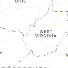
West Virginia
| Local Time | Report Details |
|---|---|
| 2:33 PM EDT | Tree down on archer hill road near highland hills drive blocking the road. time estimated via rada in brooke county WV, 32.2 miles W of Pittsburgh, PA |
| 2:35 PM EDT | Several trees down on mahan lane. time estimated via rada in brooke county WV, 31.3 miles W of Pittsburgh, PA |
| 2:50 PM EDT | Trees down in wileyville. time estimated via rada in wetzel county WV, 65.8 miles NW of Elkins, WV |
| 2:55 PM EDT | Trees down along north fork road. time estimated via rada in wetzel county WV, 62.9 miles NW of Elkins, WV |
| 3:15 PM EDT | Lines down. time estimated based on rada in ritchie county WV, 64.5 miles WNW of Elkins, WV |
| 3:25 PM EDT | Tree in roadway on cr-2 (stull hill rd.) & mtn. driv in ritchie county WV, 64.7 miles WNW of Elkins, WV |
| 3:30 PM EDT | Tree in roadway on cr-50/30 sunnyside rd. time estimated based on rada in doddridge county WV, 61.1 miles WNW of Elkins, WV |
| 3:40 PM EDT | Tree in roadway on cr-28 (nutter fork) & chips ru in doddridge county WV, 57.1 miles WNW of Elkins, WV |
| 3:43 PM EDT | Tree in roadway on cr-28/2 (477 bulltown rd west union in doddridge county WV, 56.9 miles WNW of Elkins, WV |
| 3:55 PM EDT | Tree down across fairmont road blocking the roadway. time estimated via rada in monongalia county WV, 48.5 miles NNW of Elkins, WV |
| 3:59 PM EDT | Tree down on fairmont r in monongalia county WV, 49.2 miles N of Elkins, WV |
| 4:00 PM EDT | Tree down blocking solomon road. time estimated via rada in monongalia county WV, 51.6 miles N of Elkins, WV |
| 4:05 PM EDT | Tree down along river road near intersection with hagans road. time estimated via rada in monongalia county WV, 47.3 miles NNW of Elkins, WV |
| 4:05 PM EDT | Trees and wires down along fort hill and thorne drive. time estimated via rada in marion county WV, 44.9 miles NNW of Elkins, WV |
| 4:10 PM EDT | Three trees down on wires blocking the road. time estimated via rada in monongalia county WV, 46.7 miles NNW of Elkins, WV |
| 4:10 PM EDT | Multiple trees down in the area. time estimated based on rada in harrison county WV, 35.4 miles WNW of Elkins, WV |
| 4:15 PM EDT | Tree down across hildebrand lock and dam road blocking the entire road. time estimated via rada in monongalia county WV, 46.2 miles NNW of Elkins, WV |
| 4:17 PM EDT | Several large trees and wires down along grafton road. time estimated via rada in monongalia county WV, 47 miles N of Elkins, WV |
| 4:20 PM EDT | Tree down on house. time estimated based on rada in barbour county WV, 17.6 miles NNW of Elkins, WV |
| 4:20 PM EDT | Tree on house. time estimated based on rada in barbour county WV, 16.5 miles NNW of Elkins, WV |
| 4:20 PM EDT | Two power poles broken. time estimated based on rada in harrison county WV, 37 miles WNW of Elkins, WV |
| 4:20 PM EDT | Tree down on wires blocking the road. time estimated via rada in monongalia county WV, 45.1 miles N of Elkins, WV |
| 4:25 PM EDT | Tree down near old route 73 and greenville school road. time estimated via rada in preston county WV, 51 miles N of Elkins, WV |
| 4:25 PM EDT | Large tree blocking the roadway. time estimated via rada in monongalia county WV, 46.8 miles N of Elkins, WV |
| 4:30 PM EDT | Tree down blocking snake hill road. time estimated via rada in monongalia county WV, 46 miles N of Elkins, WV |
| 4:30 PM EDT | Tree fell on house. time estimated based on rada in harrison county WV, 31.7 miles WNW of Elkins, WV |
| 4:35 PM EDT | Tree down blocking the road. time estimated via rada in monongalia county WV, 38.7 miles N of Elkins, WV |
| 4:37 PM EDT | Wires down across kingwood pike with a transformer fire. time estimated via rada in monongalia county WV, 44 miles N of Elkins, WV |
| 4:40 PM EDT | Wires down along nicholson loop road. time estimated via rada in monongalia county WV, 44.6 miles N of Elkins, WV |
| 4:40 PM EDT | Tree down across loveberry run rd at laurel run rd. time estimated from rada in lewis county WV, 40.3 miles W of Elkins, WV |
| 4:44 PM EDT | Several trees down at the buckhannon country club... with some damage reported to the clubhouse. time is estimated by rada in upshur county WV, 21 miles W of Elkins, WV |
| 4:45 PM EDT | Tree down. time estimated based on rada in upshur county WV, 23 miles W of Elkins, WV |
| 4:45 PM EDT | Tree took down power lines. time estimated based on rada in upshur county WV, 22.4 miles W of Elkins, WV |
| 4:45 PM EDT | Numerous trees and power lines down across the county... specifically south of buckhanno in upshur county WV, 20.9 miles W of Elkins, WV |
| 4:48 PM EDT | Power line down. time estimated based on rada in upshur county WV, 20.9 miles W of Elkins, WV |
| 4:50 PM EDT | Tree down blocking roadway. another tree on house in the area. time estimated based on rada in upshur county WV, 21.5 miles W of Elkins, WV |
| 4:50 PM EDT | Tree knocked powerline down. time estimated based on rada in upshur county WV, 19.2 miles W of Elkins, WV |
| 5:00 PM EDT | Tree in roadway. time estimated based on rada in randolph county WV, 13.2 miles W of Elkins, WV |
| 5:10 PM EDT | Tree down. time estimated based on rada in randolph county WV, 3.1 miles SSE of Elkins, WV |
| 5:22 PM EDT | Tree damage resulting in 37 customers without power. time is estimated by rada in randolph county WV, 3 miles S of Elkins, WV |
| 5:25 PM EDT | Tree in roadway on cr-219/15 (594 harper rd elkins). time estimated based on rada in randolph county WV, 2.4 miles S of Elkins, WV |
| 5:31 PM EDT | Tree damage resulting in 19 customers without power. time is estimated by rada in nicholas county WV, 43.4 miles E of Charleston, WV |
| 5:31 PM EDT | Multiple reports of trees and power lines down near keyser w in mineral county WV, 58.5 miles NE of Elkins, WV |
| 5:32 PM EDT | Trees were down along spriggs roa in morgan county WV, 82.6 miles SSW of State College, PA |
| 5:35 PM EDT | Several trees snapped and uprooted in the ellis ridge and chenoweth creek area. one tree fell and damaged a shed. time estimated based on rada in randolph county WV, 3.3 miles SSE of Elkins, WV |
| 5:40 PM EDT | Multiple reports of trees and power lines down near new creek... w in mineral county WV, 53.9 miles NE of Elkins, WV |
| 5:41 PM EDT | Trees and a power line down at welton orchard road and snyderville roa in hardy county WV, 43.1 miles ENE of Elkins, WV |
| 5:54 PM EDT | Tree down along dickenson mountain roa in pendleton county WV, 34 miles SE of Elkins, WV |
| 5:58 PM EDT | Tree down near the intersection of jersey mountain rd. and orchard point r in hampshire county WV, 78.9 miles ENE of Elkins, WV |
| 6:05 PM EDT | Tree down at arkansaw roa in hardy county WV, 60.3 miles E of Elkins, WV |
| 6:18 PM EDT | Tree damage resulting in 376 customers without power. location and time are estimated by rada in webster county WV, 48.5 miles SW of Elkins, WV |
| 6:40 PM EDT | A tree was down down along martinsburg roa in morgan county WV, 81 miles S of State College, PA |
| 6:45 PM EDT | Tree in roadway on us-250n at mile marker 4.0. time estimated based on rada in pocahontas county WV, 28.7 miles SSE of Elkins, WV |
| 7:00 PM EDT | Tree in roadway on wv-28 at mile marker 30.0. time based on rada in pocahontas county WV, 27.5 miles S of Elkins, WV |
| 7:05 PM EDT | Tree down near morgan grove roa in jefferson county WV, 65.4 miles W of Baltimore, MD |
| 7:22 PM EDT | Power line down at johnnycake lane and rolling lan in jefferson county WV, 64 miles W of Baltimore, MD |
New York
| Local Time | Report Details |
|---|---|
| 2:45 PM EDT | Tree down along intersection of schneider road and cr10 in the town of livingsto in columbia county NY, 46.3 miles S of Schenectady, NY |
| 2:55 PM EDT | Trees and wires down between cr 10 and cr 15 along route 82 in the town of taghkani in columbia county NY, 49.1 miles SSE of Schenectady, NY |
| 2:56 PM EDT | Wires down in the road near the intersection of church road and willowbrook road in the town of livingsto in columbia county NY, 48.1 miles SSE of Schenectady, NY |
| 2:56 PM EDT | Tree on power line catching fire on route 82 near doodletown roa in columbia county NY, 52.4 miles SSE of Schenectady, NY |
| 3:10 PM EDT | Tree fell on vehicl in livingston county NY, 55.7 miles ESE of Buffalo, NY |
| 3:42 PM EDT | Tree down blocking roadwa in monroe county NY, 64.1 miles E of Buffalo, NY |
| 3:45 PM EDT | Multiple reports of trees and wires down across the tow in monroe county NY, 65.5 miles E of Buffalo, NY |
| 3:45 PM EDT | Multiple reports of trees and wires down across the tow in monroe county NY, 68.6 miles W of Syracuse, NY |
| 3:57 PM EDT | Tree down on route 5 in yates county NY, 57 miles WSW of Syracuse, NY |
| 4:11 PM EDT | Multiple reports of trees and wires down across the town and villag in orleans county NY, 43 miles NE of Buffalo, NY |
| 4:11 PM EDT | Tree and wires down in roadwa in ontario county NY, 49.9 miles WSW of Syracuse, NY |
| 4:19 PM EDT | Tree down on roy r in yates county NY, 49.8 miles WSW of Syracuse, NY |
| 4:20 PM EDT | Tree down on ny 22 northbound near the intersection of chippawalla road in dove in dutchess county NY, 70.8 miles NNE of Brooklyn, NY |
| 4:21 PM EDT | Multiple reports of trees and wires down across the tow in orleans county NY, 49.6 miles ENE of Buffalo, NY |
| 4:26 PM EDT | Multiple reports of tree and wires dow in orleans county NY, 47.8 miles NE of Buffalo, NY |
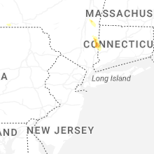
| 4:30 PM EDT | Half Dollar sized hail reported near Pawling, NY, 63.2 miles NNE of Brooklyn, NY, multiple photos on social media of quarter to 1.25 inch hail in pawling. |
| 4:30 PM EDT | Ping Pong Ball sized hail reported near Pawling, NY, 63.1 miles NNE of Brooklyn, NY, trained spotter in the village of pawling sent pictures of hail with sizes ranging between 1 inch to 1.5 inches. |
| 4:38 PM EDT | Tree... power pole... and wires down across club seneca r in schuyler county NY, 53.8 miles SW of Syracuse, NY |
| 4:38 PM EDT | Power line down... causing arcing and a small grass fir in schuyler county NY, 51.7 miles SW of Syracuse, NY |
| 4:40 PM EDT | Power poles and trees down near nichols rd causing a traffic backu in schuyler county NY, 54.3 miles SW of Syracuse, NY |
| 5:00 PM EDT | Tree and wires down on halsey s in tompkins county NY, 44.1 miles SW of Syracuse, NY |
| 5:38 PM EDT | Tree down on route 115 north of lindle in steuben county NY, 84.3 miles SW of Syracuse, NY |
| 5:38 PM EDT | Power pole down near middle rd and burch hill r in chemung county NY, 65 miles SSW of Syracuse, NY |
| 5:47 PM EDT | Multiple reports of trees and wires down throughout cornin in steuben county NY, 77.6 miles SW of Syracuse, NY |
| 5:47 PM EDT | Powerline fell on house and resulted in a fire that was later put ou in steuben county NY, 78 miles SW of Syracuse, NY |
| 5:55 PM EDT | 66 mph wind gusts recorded at mesonet station dvi03260 shoreha in suffolk county NY, 59.6 miles ENE of Brooklyn, NY |
| 5:55 PM EDT | Video of multiple trees down across wading rive in suffolk county NY, 62.9 miles ENE of Brooklyn, NY |
| 5:55 PM EDT | Multiple trees and wires down across rocky poin in suffolk county NY, 58.4 miles ENE of Brooklyn, NY |
| 5:55 PM EDT | Video of wires down causing a fire on gully road in wading river. time estimated by rada in suffolk county NY, 62.4 miles ENE of Brooklyn, NY |
| 6:00 PM EDT | Multiple trees and wires down across ridg in suffolk county NY, 60.1 miles ENE of Brooklyn, NY |
| 6:02 PM EDT | Multiple trees and wires dow in suffolk county NY, 56.6 miles ENE of Brooklyn, NY |
| 6:05 PM EDT | Branches... and fences are becoming damage in onondaga county NY, 10.2 miles NNE of Syracuse, NY |
| 6:05 PM EDT | Large tree down on wading river road in manorville. time estimated by rada in suffolk county NY, 62.8 miles E of Brooklyn, NY |
| 6:08 PM EDT | Widespread trees and wires down across shirley... mastic and mastic beac in suffolk county NY, 60.2 miles E of Brooklyn, NY |
| 6:16 PM EDT | Tree down over roadway on honeypot roa in tioga county NY, 54.6 miles S of Syracuse, NY |
| 6:35 PM EDT | Tree down over river road in lisl in broome county NY, 44.7 miles S of Syracuse, NY |
| 7:03 PM EDT | Tree down over roadway on chestnut stree in broome county NY, 49.6 miles NNW of Scranton, PA |
| 7:03 PM EDT | Tree and wires down over riverside driv in broome county NY, 50.1 miles NNW of Scranton, PA |
| 7:07 PM EDT | Tree down over baltimore avenu in broome county NY, 48.9 miles NNW of Scranton, PA |
| 7:07 PM EDT | Tree down over black river roa in broome county NY, 53.8 miles N of Scranton, PA |
| 8:20 PM EDT | 2 trees down blocking the roadway. time estimated by rada in delaware county NY, 60.4 miles NNE of Scranton, PA |
| 11:39 PM EDT | Asos station klga nyc/la guardi in queens county NY, 8.4 miles NE of Brooklyn, NY |
Connecticut
| Local Time | Report Details |
|---|---|
| 3:29 PM EDT | An amateur radio operator reported a tree down on wires on river road just north of the center of west cornwal in litchfield county CT, 70.3 miles SSE of Schenectady, NY |
| 3:29 PM EDT | A local amateur radio operator reported downed trees and wires on lower river road in west cornwall which ultimately led to a brief closure of the roa in litchfield county CT, 71.3 miles SSE of Schenectady, NY |
| 3:45 PM EDT | Tree down on wires on west morris road in the town of banta in litchfield county CT, 80.7 miles NNE of Brooklyn, NY |
| 4:22 PM EDT | Tree limbs down causing a power outage near chauncey drive in oxfor in new haven county CT, 69.1 miles NE of Brooklyn, NY |
| 4:23 PM EDT | Tree limbs down causing a power outage in seymou in new haven county CT, 68.2 miles NE of Brooklyn, NY |
| 4:25 PM EDT | Tree down on wires on homestead ave between middlefield and woodland av in new haven county CT, 78.6 miles NE of Brooklyn, NY |
| 4:30 PM EDT | Tree down on wires down on oxford road... oneill road and coppermine road in oxford c in new haven county CT, 68.2 miles NE of Brooklyn, NY |
| 4:32 PM EDT | Tree limbs down causing a power outage near taber road in sherma in fairfield county CT, 68.3 miles NNE of Brooklyn, NY |
| 4:46 PM EDT | Tree limbs down causing a power outage near candle hill road in inglenoo in fairfield county CT, 63.2 miles NNE of Brooklyn, NY |
| 5:00 PM EDT | Tree down on wires with small fire on milwaukee ave near oxford stree in fairfield county CT, 56 miles NNE of Brooklyn, NY |
| 5:10 PM EDT | Tree down with wires across route 34 at great hill road and fountain lake road. road is close in new haven county CT, 64.6 miles NE of Brooklyn, NY |
| 5:20 PM EDT | Tree snapped in hal in fairfield county CT, 50.4 miles NE of Brooklyn, NY |
| 5:20 PM EDT | Tree down on car on route 12 in gales ferr in new london county CT, 44 miles SW of Providence, RI |
Texas
| Local Time | Report Details |
|---|---|
| 3:10 PM CDT | West texas mesonet station 156 marfa 13s in presidio county TX, 19.7 miles SW of Alpine, TX |
| 6:00 PM CDT | Tree uprooted on 7th and hackberry s in reeves county TX, 73.1 miles WSW of Odessa, TX |
| 6:12 PM CDT | Carport blown over along with numerous trees uprooted across tow in reeves county TX, 72.6 miles WSW of Odessa, TX |
| 7:12 PM CDT | Quarter sized hail reported near Childress, TX, 0.6 miles E of Childress, TX |
| 7:27 PM CDT | Quarter sized hail reported near Levelland, TX, 30.2 miles W of Lubbock, TX |
| 8:16 PM CDT | Measured by the ttu mesone in dickens county TX, 48.6 miles ENE of Lubbock, TX |
| 11:15 PM CDT | Tahoka wt in lynn county TX, 26.7 miles S of Lubbock, TX |
| 11:19 PM CDT | Tahoka wt in lynn county TX, 26.7 miles S of Lubbock, TX |
| 11:45 PM CDT | Odonnell wtm. outflow wind gus in lynn county TX, 42.2 miles S of Lubbock, TX |
| 11:46 PM CDT | Wt in lynn county TX, 42.2 miles S of Lubbock, TX |
Maryland
| Local Time | Report Details |
|---|---|
| 4:50 PM EDT | Multiple downed trees and utility lines reported on bear creek roa in garrett county MD, 56.3 miles NNE of Elkins, WV |
| 5:09 PM EDT | Tree down reported on george washington highwa in garrett county MD, 35.6 miles NE of Elkins, WV |
| 5:09 PM EDT | Tree down at silver knob roa in garrett county MD, 35.9 miles NE of Elkins, WV |
| 5:14 PM EDT | Multiple trees down at memorial drive and broadford roa in garrett county MD, 42.7 miles NE of Elkins, WV |
| 5:35 PM EDT | A few trees were down in barto in allegany county MD, 60.9 miles NE of Elkins, WV |
| 5:41 PM EDT | A few trees were down in midlan in allegany county MD, 66.4 miles NE of Elkins, WV |
| 5:45 PM EDT | A few trees were down in cumberlan in allegany county MD, 76.7 miles NE of Elkins, WV |
| 7:09 PM EDT | Personal weather station in maugansville reported 50 kts (57.5 mph) in washington county MD, 66.9 miles WNW of Baltimore, MD |
| 7:09 PM EDT | A couple trees were down in williamspor in washington county MD, 68.2 miles WNW of Baltimore, MD |
| 7:14 PM EDT | A couple trees were down in maugansvill in washington county MD, 66.9 miles WNW of Baltimore, MD |
| 7:33 PM EDT | Several trees down in middletow in frederick county MD, 44.5 miles WNW of Baltimore, MD |
| 7:40 PM EDT | Several trees were down in frederic in frederick county MD, 44.5 miles WNW of Baltimore, MD |
| 7:54 PM EDT | Several trees were down in new marke in frederick county MD, 35.9 miles W of Baltimore, MD |
| 7:54 PM EDT | A couple trees were down in maugansvill in washington county MD, 66.9 miles WNW of Baltimore, MD |
| 8:08 PM EDT | Large tree limbs dow in montgomery county MD, 30.6 miles SW of Baltimore, MD |
| 8:16 PM EDT | Tree down at london bridge roa in carroll county MD, 21.7 miles WNW of Baltimore, MD |
| 8:26 PM EDT | Storm damage reported in prince georges county MD, 36.6 miles SSW of Baltimore, MD |
| 8:32 PM EDT | Trees down in reisterstown are in baltimore county MD, 14.1 miles NW of Baltimore, MD |
| 8:35 PM EDT | Numerous trees are down in prince georges count in prince georges county MD, 31 miles SSW of Baltimore, MD |
| 8:35 PM EDT | Large tree down on the front yard in prince georges county MD, 30.5 miles SSW of Baltimore, MD |
| 8:42 PM EDT | Trees down in hereford are in baltimore county MD, 20.9 miles N of Baltimore, MD |
| 8:52 PM EDT | Multiple trees resported down near odenton... m in anne arundel county MD, 19.7 miles S of Baltimore, MD |
| 8:56 PM EDT | Multiple trees down near dunkirk and prince frederic in calvert county MD, 51.1 miles S of Baltimore, MD |
| 8:56 PM EDT | Tree down at kent street and sidney avenu in baltimore city county MD, 1.8 miles SW of Baltimore, MD |
| 9:04 PM EDT | Bay bridge mesone in queen anne's county MD, 25.6 miles SE of Baltimore, MD |
| 9:05 PM EDT | Multiple trees down near chesapeake beac in calvert county MD, 40.9 miles S of Baltimore, MD |
| 9:20 PM EDT | Tree down on wires. time estimated by rada in queen anne's county MD, 28.8 miles SE of Baltimore, MD |
| 9:20 PM EDT | Large tree limb down on wires. time estimated by rada in queen anne's county MD, 27.7 miles SE of Baltimore, MD |
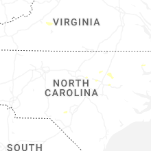
North Carolina
| Local Time | Report Details |
|---|---|
| 5:29 PM EDT | Trees down on powerlines with multiple areas without power across red oak and northern nashville n in nash county NC, 43.6 miles ENE of Raleigh, NC |
| 5:40 PM EDT | Large trees down on raleigh road and nashville r in nash county NC, 47.2 miles ENE of Raleigh, NC |
| 5:40 PM EDT | Large trees down on raleigh road and nashville r in nash county NC, 47.2 miles ENE of Raleigh, NC |
| 5:45 PM EDT | Large boat on trailer slide 10-15ft off concrete pad due to strong wind gust in nash county NC, 46.8 miles ENE of Raleigh, NC |
| 5:50 PM EDT | Tree down along us 64 in edgecombe county NC, 55.5 miles E of Raleigh, NC |
| 5:55 PM EDT | Tree down on us hwy 301 in battlebor in nash county NC, 53.3 miles ENE of Raleigh, NC |
| 6:05 PM EDT | Trees down near bulluck elem schoo in edgecombe county NC, 52.2 miles E of Raleigh, NC |
| 6:05 PM EDT | Metal carport blown over off bulluck school roa in edgecombe county NC, 51.7 miles E of Raleigh, NC |
| 6:10 PM EDT | Tree down on hwy 25 in edgecombe county NC, 65.3 miles E of Raleigh, NC |
| 6:40 PM EDT | Road closed due to trees on roadwa in edgecombe county NC, 58.2 miles E of Raleigh, NC |
| 6:40 PM EDT | Trees down in middlesex/baile in nash county NC, 27.7 miles E of Raleigh, NC |
| 6:47 PM EDT | Tree down on roadwa in wake county NC, 9.7 miles ENE of Raleigh, NC |
| 6:50 PM EDT | Tree down on powerlines near poole road and huntsboro roa in wake county NC, 10.6 miles ESE of Raleigh, NC |
| 8:06 PM EDT | Corrects the time of previous tstm wnd dmg report from 3 sse nahunta. tree down on powerlines off nor-am roa in wayne county NC, 40.3 miles ESE of Raleigh, NC |
| 8:33 PM EDT | Tree down on powerlines off nor-am roa in wayne county NC, 40.3 miles ESE of Raleigh, NC |
| 9:13 PM EDT | Tree down on powerline in hoke county NC, 63.8 miles SSW of Raleigh, NC |
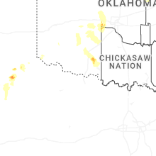
Kansas
| Local Time | Report Details |
|---|---|
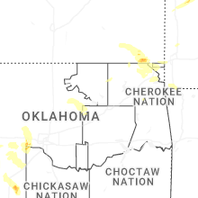
| 4:56 PM CDT | Half Dollar sized hail reported near Cherryvale, KS, 29.2 miles SSW of Chanute, KS |
| 5:46 PM CDT | Quarter sized hail reported near Altamont, KS, 36.7 miles SSE of Chanute, KS |
| 6:02 PM CDT | Very large tree limbs down... time estimated by rada in labette county KS, 43.8 miles SSE of Chanute, KS |
| 6:20 PM CDT | Quarter sized hail reported near Chetopa, KS, 44.9 miles SSE of Chanute, KS, corrects previous hail report from bartlett. |
| 6:28 PM CDT | Quarter sized hail reported near Chetopa, KS, 44.9 miles SSE of Chanute, KS |
| 8:02 PM CDT | Quarter sized hail reported near Baxter Springs, KS, 60.7 miles SE of Chanute, KS, report from mping... quarter 1.00 in. |
| 8:03 PM CDT | Half Dollar sized hail reported near Baxter Springs, KS, 60.7 miles SE of Chanute, KS, report from mping... half dollar 1.25 in. |
Virginia
| Local Time | Report Details |
|---|---|
| 6:13 PM EDT | Large tree down blocking both directions of brocks gap rd. west of folks ru in rockingham county VA, 53.1 miles ESE of Elkins, WV |
| 6:32 PM EDT | Multiple reports of trees and power lines down across shenandoah count in shenandoah county VA, 66.6 miles E of Elkins, WV |
| 6:37 PM EDT | Quarter sized hail reported near Goodview, VA, 8.3 miles E of Roanoke, VA |
| 6:43 PM EDT | Major tree down on michael road... with several trees reported down on nearby streets in page county VA, 77.1 miles E of Elkins, WV |
| 6:46 PM EDT | Tree blown down along saunders grove drive... south of cochese driv in bedford county VA, 14.4 miles E of Roanoke, VA |
| 6:48 PM EDT | Large tree branch down at residence in page county VA, 78.5 miles ESE of Elkins, WV |
| 6:52 PM EDT | Tree blown down at intersection of dickerson mill road and mead valley roa in bedford county VA, 16.6 miles E of Roanoke, VA |
| 6:53 PM EDT | Tree blown down off dickerson mill road near sumdat trai in bedford county VA, 16.6 miles E of Roanoke, VA |
| 6:54 PM EDT | Multiple trees were down across frederick count in frederick county VA, 87.4 miles W of Baltimore, MD |
| 6:55 PM EDT | Several trees down in rileyvill in page county VA, 79.2 miles E of Elkins, WV |
| 6:55 PM EDT | Several trees were down around and north of lura in page county VA, 76.9 miles ESE of Elkins, WV |
| 6:55 PM EDT | Large tree was downa long the 3000 block of kimball road in lura in page county VA, 77.4 miles E of Elkins, WV |
| 7:03 PM EDT | Tree down off dickerson mill road... north of the intersection of shepherds store roa in bedford county VA, 18.8 miles E of Roanoke, VA |
| 7:03 PM EDT | Numerous trees down in front roya in warren county VA, 88.2 miles WSW of Baltimore, MD |
| 7:11 PM EDT | Tree down near intersection of bunker hill loop and mcdaniel roa in bedford county VA, 21.5 miles E of Roanoke, VA |
| 7:12 PM EDT | Tree down on road. time estimated based on rada in pocahontas county WV, 25.3 miles SSE of Elkins, WV |
| 7:14 PM EDT | Tree down at auburn road and wickcliffe roa in clarke county VA, 69.8 miles W of Baltimore, MD |
| 7:22 PM EDT | Tree down on north blue ridge turnpik in madison county VA, 72.9 miles NNW of Richmond, VA |
| 7:31 PM EDT | A couple trees were down in round hil in loudoun county VA, 63.3 miles W of Baltimore, MD |
| 7:31 PM EDT | A couple trees were down in round hil in loudoun county VA, 52.7 miles WSW of Baltimore, MD |
| 7:32 PM EDT | Smattering of trees down into power lines and across roads in warrenton in fauquier county VA, 75.2 miles WSW of Baltimore, MD |
| 7:40 PM EDT | A couple trees were down in philomon in loudoun county VA, 62.7 miles WSW of Baltimore, MD |
| 7:47 PM EDT | Tree down at leon roa in madison county VA, 68.4 miles NNW of Richmond, VA |
| 7:58 PM EDT | Numerous trees down through the count in fairfax county VA, 50.9 miles SW of Baltimore, MD |
| 8:07 PM EDT | There were three separate calls for trees that fell onto houses in fairfa in fairfax county VA, 50.9 miles SW of Baltimore, MD |
| 8:17 PM EDT | Storm damage reported in arlington county VA, 37.9 miles SW of Baltimore, MD |
| 8:21 PM EDT | Quantico reported a 51 knot gust as thunderstorms/outflow moved through in stafford county VA, 66.3 miles SW of Baltimore, MD |
| 8:25 PM EDT | Mutliple reports of trees and power lines down throughout the city of alexandri in city of alexandria county VA, 40.4 miles SW of Baltimore, MD |
Oklahoma
| Local Time | Report Details |
|---|---|
| 6:00 PM CDT | Golf Ball sized hail reported near El Reno, OK, 26.2 miles W of Oklahoma City, OK |
| 6:07 PM CDT | Tennis Ball sized hail reported near El Reno, OK, 26.5 miles W of Oklahoma City, OK |
| 6:15 PM CDT | Half Dollar sized hail reported near Union City, OK, 25.1 miles W of Oklahoma City, OK, report from mping. |
| 6:27 PM CDT | Golf Ball sized hail reported near Union City, OK, 24.3 miles WSW of Oklahoma City, OK |
| 7:10 PM CDT | Half Dollar sized hail reported near Mountain View, OK, 74.1 miles WSW of Oklahoma City, OK, report from mping. |
| 7:20 PM CDT | Spotter reported gust south of miami on highway 6 in ottawa county OK, 64.3 miles SSE of Chanute, KS |
| 7:25 PM CDT | Relayed from social medi in ottawa county OK, 69.9 miles SSE of Chanute, KS |
| 7:30 PM CDT | At least 2 trees plus some power lines down in the city of miami. time estimated from rada in ottawa county OK, 64.3 miles SSE of Chanute, KS |
| 9:15 PM CDT | Tree damage near ft. sill. time estimated from rada in comanche county OK, 51.5 miles N of Wichita Falls, TX |
| 9:20 PM CDT | Storm damage reported in comanche county OK, 46.6 miles N of Wichita Falls, TX |
| 9:29 PM CDT | Measured at kla in comanche county OK, 46.6 miles N of Wichita Falls, TX |
| 9:30 PM CDT | Tree downed on a hous in comanche county OK, 47.3 miles N of Wichita Falls, TX |
| 9:34 PM CDT | Corrects time for previous tstm wnd gst report from 6 se lawton. personal weather station... measured at 10 m heigh in comanche county OK, 45.4 miles NNE of Wichita Falls, TX |
| 9:35 PM CDT | Measured at kwso-t in comanche county OK, 48.1 miles NNE of Wichita Falls, TX |
| 9:35 PM CDT | One mile section of transmission lines blown down between se 45th and se 60th street along goodlin road. time estimated from radar and surrounding report in comanche county OK, 44.6 miles NNE of Wichita Falls, TX |
| 9:55 PM CDT | Storm damage reported in cotton county OK, 34.8 miles NNE of Wichita Falls, TX |
| 10:11 PM CDT | Personal weather station... measured at 10 m heigh in comanche county OK, 45.4 miles NNE of Wichita Falls, TX |
| 11:30 PM CDT | 60 to 65 mph wind gust estimate near gideo in cherokee county OK, 54.8 miles E of Tulsa, OK |
District of Columbia
| Local Time | Report Details |
|---|---|
| 8:09 PM EDT | Several calls for trees down around glen echo in montgomery county MD, 34.9 miles SW of Baltimore, MD |
| 8:16 PM EDT | A tree was down along 27th street and dumbarton street n in district of columb county DC, 35.7 miles SW of Baltimore, MD |
| 8:24 PM EDT | Personal weather station in logan circle reported 53 kts (61.3 mph) in district of columb county DC, 34.6 miles SW of Baltimore, MD |
| 8:25 PM EDT | A tree was down along the 700 block of 16th street s in district of columb county DC, 34.6 miles SW of Baltimore, MD |
| 8:32 PM EDT | A tree was down along 154 d street s in district of columb county DC, 34.3 miles SW of Baltimore, MD |
Indiana
| Local Time | Report Details |
|---|---|
| 7:16 PM CDT | Multiple large branches broken... tree branches on house... near 93rd avenue and northcote avenu in lake county IN, 31 miles SSE of Chicago, IL |
| 7:25 PM CDT | Roof damage to andrean high school in merrillville. multiple large branches broken in the vicinity. possible tornado. relayed via broadcast medi in lake county IN, 30.2 miles SSE of Chicago, IL |
| 8:00 PM CDT | Private weather station kinkentl6 reported 69 mph wind gust just prior to gauge outag in newton county IN, 75 miles S of Chicago, IL |
| 8:05 PM CDT | Peak gust measured on personal weather statio in newton county IN, 70.3 miles S of Chicago, IL |
| 8:10 PM CDT | Peak gust with initial round of evening storms at michigan city glerl statio in lmz745 county IN, 38.8 miles ESE of Chicago, IL |
| 9:24 PM EDT | Peak gust measured on personal weather station before data stopped being reporte in benton county IN, 73.9 miles NW of Indianapolis, IN |
| 9:30 PM EDT | 2 semis blown over on i-6 in tippecanoe county IN, 67.1 miles NW of Indianapolis, IN |
| 9:47 PM EDT | Tree downed onto truc in cass county IN, 67 miles NNW of Indianapolis, IN |
| 9:51 PM EDT | Measured from personal weather statio in montgomery county IN, 41.8 miles NW of Indianapolis, IN |
| 9:52 PM EDT | Numerous trees dow in cass county IN, 69.5 miles N of Indianapolis, IN |
| 9:55 PM EDT | Tree dow in cass county IN, 69.4 miles WSW of Fort Wayne, IN |
| 9:59 PM EDT | Measured from personal weather statio in clinton county IN, 41.4 miles NNW of Indianapolis, IN |
| 10:00 PM EDT | Trees down across the street from church. branches estimated 2-4 in. diamete in miami county IN, 52.7 miles WSW of Fort Wayne, IN |
| 10:00 PM EDT | Measured from personal weather statio in clinton county IN, 33.3 miles NNW of Indianapolis, IN |
| 10:00 PM EDT | 8 healthy trees down... 12 to 14 inches in diamete in clinton county IN, 31.1 miles NNW of Indianapolis, IN |
| 10:02 PM EDT | Four large trees dow in cass county IN, 61.4 miles WSW of Fort Wayne, IN |
| 10:04 PM EDT | Storm damage reported in miami county IN, 60.9 miles N of Indianapolis, IN |
| 9:06 PM CDT | Peak gust with second round of evening storms at michigan city glerl statio in lmz745 county IN, 38.8 miles ESE of Chicago, IL |
| 10:07 PM EDT | Storm damage reported in miami county IN, 55.6 miles WSW of Fort Wayne, IN |
| 10:15 PM EDT | Trees and power lines down in the county... especially along the 331 corridor and across 10 to argo in marshall county IN, 56.5 miles WNW of Fort Wayne, IN |
| 10:15 PM EDT | Tree on powerline in marshall county IN, 63.9 miles WNW of Fort Wayne, IN |
| 10:19 PM EDT | Measured from personal weather statio in hamilton county IN, 30.1 miles N of Indianapolis, IN |
| 10:20 PM EDT | Storm damage reported in putnam county IN, 45.8 miles W of Indianapolis, IN |
| 10:22 PM EDT | Multiple structures impacte in marshall county IN, 53.3 miles WNW of Fort Wayne, IN |
| 10:22 PM EDT | House shifted off foundation and windows blown out. several trees down in the are in wabash county IN, 43.3 miles WSW of Fort Wayne, IN |
| 10:24 PM EDT | Storm damage reported in tipton county IN, 31.3 miles N of Indianapolis, IN |
| 10:25 PM EDT | Multiple trees and power lines throughout howard count in howard county IN, 49.2 miles N of Indianapolis, IN |
| 10:27 PM EDT | Tree on house and multiple broken limb in kosciusko county IN, 48.1 miles WNW of Fort Wayne, IN |
| 10:30 PM EDT | Tree damag in wabash county IN, 36.5 miles W of Fort Wayne, IN |
| 10:30 PM EDT | Numerous trees down in the south bend are in st. joseph county IN, 72.3 miles E of Chicago, IL |
| 10:30 PM EDT | Siding ripped off the house. 2 trees down. part of the roof of the barn is across the road in the woods stuck in tree in huntington county IN, 32.1 miles WSW of Fort Wayne, IN |
| 10:30 PM EDT | Tree down across road. from social media. time estimated from rada in hendricks county IN, 22 miles W of Indianapolis, IN |
| 10:31 PM EDT | Large tree branch snapped... laying across a roa in hamilton county IN, 30 miles N of Indianapolis, IN |
| 10:32 PM EDT | Several trees dow in grant county IN, 47 miles SW of Fort Wayne, IN |
| 10:35 PM EDT | Storm damage reported in grant county IN, 50.6 miles SW of Fort Wayne, IN |
| 10:35 PM EDT | Roof ripped off hous in huntington county IN, 27.8 miles WSW of Fort Wayne, IN |
| 10:42 PM EDT | Large tree and numerous branches dow in elkhart county IN, 57.8 miles NW of Fort Wayne, IN |
| 10:42 PM EDT | Damage to a hous in huntington county IN, 22.2 miles WSW of Fort Wayne, IN |
| 10:43 PM EDT | Storm damage reported in kosciusko county IN, 37 miles WNW of Fort Wayne, IN |
| 10:45 PM EDT | Several homes damaged and trees dow in elkhart county IN, 60.1 miles NW of Fort Wayne, IN |
| 10:50 PM EDT | Corrects time of previous tstm wnd gst report from maho in huntington county IN, 17.4 miles WSW of Fort Wayne, IN |
| 10:50 PM EDT | Reports of power lines down in the lapel and anderson area in madison county IN, 26.3 miles NE of Indianapolis, IN |
| 10:52 PM EDT | 18 inch diameter tree uprooted. time estimated via rada in marion county IN, 7.8 miles SSW of Indianapolis, IN |
| 10:55 PM EDT | Storm damage reported in elkhart county IN, 64.2 miles NW of Fort Wayne, IN |
| 11:00 PM EDT | Numerous reports of damag in jay county IN, 37.7 miles S of Fort Wayne, IN |
| 11:00 PM EDT | Storm damage reported in wells county IN, 24.1 miles S of Fort Wayne, IN |
| 11:00 PM EDT | Tree snappe in allen county IN, 9 miles WSW of Fort Wayne, IN |
| 11:03 PM EDT | 30 ft long live tree branch 7 to 8 inches diameter is down across peterman roa in johnson county IN, 10.3 miles S of Indianapolis, IN |
| 11:05 PM EDT | Large mature white pine snapped off 15 feet above ground... large locust tree uprooted... large limbs stripped from mature oak and maple tree in lagrange county IN, 48.9 miles NNW of Fort Wayne, IN |
| 11:08 PM EDT | Storm damage reported in allen county IN, 8.1 miles SW of Fort Wayne, IN |
| 11:08 PM EDT | House crushed by tree. time estimated via rada in delaware county IN, 51.1 miles NE of Indianapolis, IN |
| 11:12 PM EDT | A shed was destroyed from a nearby trailer par in allen county IN, 4 miles SSE of Fort Wayne, IN |
| 11:15 PM EDT | Storm damage reported in huntington county IN, 17.4 miles WSW of Fort Wayne, IN |
| 11:20 PM EDT | Corrects previous non-tstm wnd gst report from 4 wsw woodbur in allen county IN, 9.6 miles ENE of Fort Wayne, IN |
| 11:25 PM EDT | Tree into hous in steuben county IN, 44.6 miles N of Fort Wayne, IN |
| 11:25 PM EDT | Trees dow in steuben county IN, 39.3 miles N of Fort Wayne, IN |
| 11:30 PM EDT | Trees down north of state road 44 and east of 500 east. time estimate in shelby county IN, 28.7 miles ESE of Indianapolis, IN |
| 11:40 PM EDT | Tree in the roadway on state road 44 near the west county lin in rush county IN, 30.9 miles ESE of Indianapolis, IN |
| 11:53 PM EDT | Tree downed in richmond. time estimated by rada in wayne county IN, 54 miles NNW of Cincinnati, OH |
| 11:53 PM EDT | Tree downed along mcminn road. time estimated by rada in wayne county IN, 56.1 miles NNW of Cincinnati, OH |
Michigan
| Local Time | Report Details |
|---|---|
| 8:55 PM EDT | 6 inch brand down at intersection of chicago and south waverly in hollan in ottawa county MI, 23.7 miles WSW of Grand Rapids, MI |
| 9:00 PM EDT | Trees and power lines dow in ottawa county MI, 20.8 miles WSW of Grand Rapids, MI |
| 9:00 PM EDT | Trees and power lines dow in ottawa county MI, 20.8 miles WSW of Grand Rapids, MI |
| 9:05 PM EDT | Trees and wires down on yard along west mckinley avenu in ottawa county MI, 20.4 miles WSW of Grand Rapids, MI |
| 9:09 PM EDT | Trees and wires down at cutler and cedar street in allegan m in allegan county MI, 31.5 miles SSW of Grand Rapids, MI |
| 9:19 PM EDT | Tree on roadwa in kent county MI, 6.3 miles NNE of Grand Rapids, MI |
| 9:32 PM EDT | Reports of trees down in the area and to the east. time estimated with rada in kent county MI, 17.1 miles SE of Grand Rapids, MI |
| 9:43 PM EDT | Trees down. time estimated with rada in newaygo county MI, 22.6 miles N of Grand Rapids, MI |
| 9:51 PM EDT | Extensive tree damage with multiple trees down along m 66 just past bippley roa in ionia county MI, 32.1 miles ESE of Grand Rapids, MI |
| 10:32 PM EDT | Social media photo shows tree uprooted in laingsburg... m in shiawassee county MI, 34.7 miles WSW of Flint, MI |
| 10:47 PM EDT | Social media photo shows large branch split from tree onto roa in shiawassee county MI, 25 miles W of Flint, MI |
| 10:55 PM EDT | Truck blown off the roa in st. joseph county MI, 57.9 miles NNW of Fort Wayne, IN |
| 11:10 PM EDT | Trees and powerlines dow in st. joseph county MI, 52.7 miles NNW of Fort Wayne, IN |
| 11:17 PM EDT | Storm damage reported in st. joseph county MI, 53.7 miles NNW of Fort Wayne, IN |
| 11:25 PM EDT | Powerlines dow in branch county MI, 55 miles N of Fort Wayne, IN |
| 12:19 AM EDT | Social media photo shows tree down in onste in lenawee county MI, 73.7 miles SSW of Flint, MI |
| 12:20 AM EDT | A large tree was blown down due to thunderstorm wind in lenawee county MI, 68.3 miles S of Flint, MI |
| 12:46 AM EDT | Report of multiple large trees and wires down across northern monroe count in monroe county MI, 69.1 miles S of Flint, MI |
| 4:58 AM UTC | Media relayed photos of a large tree down on a house... partially destroying a chimne in wayne county MI, 53.4 miles SSE of Flint, MI |
| 1:02 AM EDT | A large tree and wires were blown down do to thunderstorms wind in oakland county MI, 47.4 miles SE of Flint, MI |
| 1:16 AM EDT | Storm damage reported in monroe county MI, 75.1 miles SSE of Flint, MI |
| 1:19 AM EDT | Storm damage reported in wayne county MI, 57.7 miles SE of Flint, MI |
New Jersey
| Local Time | Report Details |
|---|---|
| 9:34 PM EDT | Reports of numerous trees and wires down across the town of mendha in morris county NJ, 32.6 miles W of Brooklyn, NY |
| 9:45 PM EDT | Large tree branch down on willow way in berkeley height in union county NJ, 24.2 miles W of Brooklyn, NY |
| 9:49 PM EDT | Several reports of trees and wires down in morristown. time estimated from rada in morris county NJ, 26.7 miles WNW of Brooklyn, NY |
| 10:10 PM EDT | Trees down near thomas lane. time estimated by rada in sussex county NJ, 51.7 miles ESE of Scranton, PA |
| 10:15 PM EDT | Downed trees near the intersection of libertyville rd and county road 519. time estimated by rada in sussex county NJ, 52.4 miles NW of Brooklyn, NY |
Arkansas
| Local Time | Report Details |
|---|---|
| 10:17 PM CDT | Half Dollar sized hail reported near Bentonville, AR, 72.9 miles N of Fort Smith, AR, time estimated from radar. |
Connect with Interactive Hail Maps