

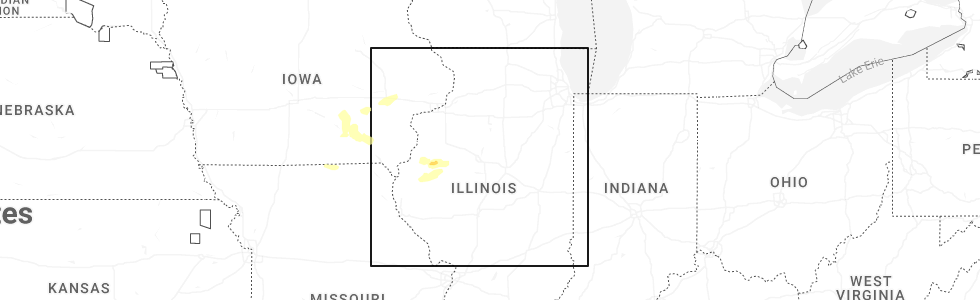
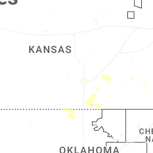
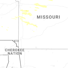
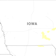
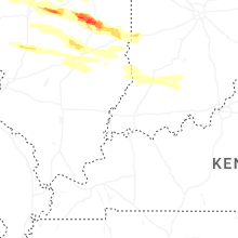
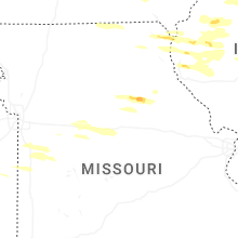
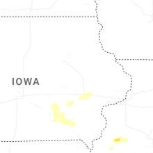
Hail Map for Wednesday, June 17, 2026
Number of Impacted Households on 6/17/2026
0
Impacted by 1" or Larger Hail
0
Impacted by 1.75" or Larger Hail
0
Impacted by 2.5" or Larger Hail
Square Miles of Populated Area Impacted on 6/17/2026
0
Impacted by 1" or Larger Hail
0
Impacted by 1.75" or Larger Hail
0
Impacted by 2.5" or Larger Hail

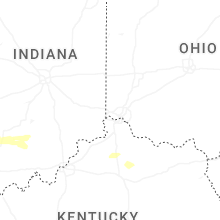
Cities Most Affected by Hail Storms of 6/17/2026
| Hail Size | Demographics of Zip Codes Affected | ||||||
|---|---|---|---|---|---|---|---|
| City | Count | Average | Largest | Pop Density | House Value | Income | Age |
| Lovington, IL | 3 | 2.42 | 3.00 | 14 | $66k | $40.1k | 39.1 |
| Illiopolis, IL | 4 | 1.75 | 1.75 | 21 | $71k | $50.8k | 39.1 |
| Arthur, IL | 3 | 2.25 | 3.00 | 75 | $71k | $38.8k | 31.8 |
| Humboldt, IL | 2 | 2.63 | 2.75 | 30 | $56k | $35.8k | 37.3 |
| Charleston, IL | 2 | 2.25 | 2.75 | 145 | $83k | $28.0k | 23.8 |
| Boody, IL | 2 | 1.75 | 1.75 | 0 | $37k | $39.9k | 41.7 |
| Arcola, IL | 1 | 3.00 | 3.00 | 41 | $75k | $39.8k | 36.0 |
| Holden, MO | 1 | 2.00 | 2.00 | 39 | $72k | $37.6k | 41.4 |
| Niantic, IL | 1 | 2.00 | 2.00 | 13 | $72k | $41.3k | 38.4 |
| Nelson, MO | 1 | 2.00 | 2.00 | 9 | $38k | $33.3k | 45.1 |
Hail and Wind Damage Spotted on 6/17/2026
Filter by Report Type:Hail ReportsWind Reports
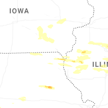
States Impacted
Iowa, Illinois, Indiana, Alabama, South Dakota, Missouri, Minnesota, Wisconsin, Arizona, Florida, New Mexico, Texas, Ohio, Kentucky, West Virginia, LouisianaIowa
| Local Time | Report Details |
|---|---|
| 7:01 AM CDT | Tree snapped at locatio in benton county IA, 8.1 miles W of Cedar Rapids, IA |
| 7:01 AM CDT | Storm damage reported in linn county IA, 6.9 miles SSW of Cedar Rapids, IA |
| 7:04 AM CDT | Tree fell and damaged fence on washington av in johnson county IA, 16 miles SSE of Cedar Rapids, IA |
| 7:04 AM CDT | Storm damage reported in johnson county IA, 15.2 miles S of Cedar Rapids, IA |
| 7:05 AM CDT | Large tree down with limbs 6 to 8 inches in diamete in johnson county IA, 16 miles SSE of Cedar Rapids, IA |
| 7:11 AM CDT | Firework sales tent collapse in linn county IA, 10.4 miles SW of Cedar Rapids, IA |
| 7:11 AM CDT | Storm damage reported in johnson county IA, 15.2 miles S of Cedar Rapids, IA |
| 7:14 AM CDT | Storm damage reported in johnson county IA, 16 miles SSE of Cedar Rapids, IA |
| 7:15 AM CDT | Estimated wind gust. torrential rainfall also occurring at time of repor in linn county IA, 3.3 miles E of Cedar Rapids, IA |
| 7:24 AM CDT | Roof off of a machine shed with large trees down at the locatio in jefferson county IA, 56 miles NNW of Kahoka, MO |
| 7:40 AM CDT | Storm damage reported in cedar county IA, 39.2 miles ESE of Cedar Rapids, IA |
| 8:00 AM CDT | Multiple power lines down in town... tree down on a hous in des moines county IA, 49.8 miles NE of Kahoka, MO |
| 8:00 AM CDT | Utility poles and power lines down... time estimated from rada in des moines county IA, 47 miles NE of Kahoka, MO |
| 8:02 AM CDT | Corrects previous tstm wnd gst report from 3 nw kingsto in des moines county IA, 53.6 miles NE of Kahoka, MO |
| 8:05 AM CDT | Tree down on house along with many powerlines dow in des moines county IA, 50.2 miles NE of Kahoka, MO |
| 8:07 AM CDT | Trees and power lines down... time estimated from rada in des moines county IA, 41.5 miles NE of Kahoka, MO |
| 8:14 AM CDT | Trees down with one on a home. time estimated from rada in des moines county IA, 40.9 miles NE of Kahoka, MO |
| 8:15 AM CDT | Awning blown off mobile home. still had 45 to 50 mph winds 10 minutes late in des moines county IA, 39.9 miles NE of Kahoka, MO |
| 8:18 AM CDT | Storm damage reported in des moines county IA, 53.6 miles NE of Kahoka, MO |
| 8:21 AM CDT | Storm damage reported in des moines county IA, 40.1 miles NE of Kahoka, MO |
| 5:25 PM CDT | Tree limbs down up to 5 1/2 inch in diamete in sioux county IA, 32.2 miles SE of Sioux Falls, SD |
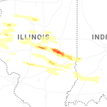
Illinois
| Local Time | Report Details |
|---|---|
| 7:36 AM CDT | Roof damage to multiple buildings in downtown marshall on archer st. report received from faceboo in clark county IL, 37.2 miles E of Mattoon, IL |
| 8:13 AM CDT | Storm damage reported in rock island county IL, 70.3 miles ESE of Cedar Rapids, IA |
| 8:14 AM CDT | Storm damage reported in rock island county IL, 70.5 miles ESE of Cedar Rapids, IA |
| 8:15 AM CDT | Storm damage reported in rock island county IL, 70.7 miles ESE of Cedar Rapids, IA |
| 8:21 AM CDT | Storm damage reported in henderson county IL, 57.6 miles NE of Kahoka, MO |
| 8:22 AM CDT | Tree tops snapped at the locatio in warren county IL, 60 miles WNW of Peoria, IL |
| 8:23 AM CDT | Storm damage reported in henderson county IL, 54 miles ENE of Kahoka, MO |
| 8:28 AM CDT | Storm damage reported in mercer county IL, 57.6 miles NW of Peoria, IL |
| 8:30 AM CDT | Roof off building downtow in warren county IL, 57.7 miles WNW of Peoria, IL |
| 8:35 AM CDT | Derailment of a few train cars by the win in warren county IL, 54.9 miles WNW of Peoria, IL |
| 8:37 AM CDT | Tree on powerline at east knox rd. and day st. power outage reporte in knox county IL, 44.7 miles WNW of Peoria, IL |
| 8:39 AM CDT | Storm damage reported in henry county IL, 51.8 miles NW of Peoria, IL |
| 8:43 AM CDT | Spotter reports widespread tree damage across northern warren county with many whole trees down and large branches dow in warren county IL, 58.4 miles WNW of Peoria, IL |
| 8:55 AM CDT | Damage to funeral home and power outage reporte in knox county IL, 28 miles NW of Peoria, IL |
| 9:08 AM CDT | Trees down in tow in hancock county IL, 15.8 miles ESE of Kahoka, MO |
| 9:11 AM CDT | Relayed through emergency managemen in peoria county IL, 18.7 miles NNW of Peoria, IL |
| 9:15 AM CDT | Relayed through emergency managemen in peoria county IL, 12.6 miles NNW of Peoria, IL |
| 9:19 AM CDT | Relayed through emergency managemen in peoria county IL, 4.8 miles W of Peoria, IL |
| 9:23 AM CDT | Tree down on il-29...south of cedar hills d in woodford county IL, 11.2 miles NNE of Peoria, IL |
| 9:37 AM CDT | 12 inch diameter tree limb dow in tazewell county IL, 7.5 miles ENE of Peoria, IL |
| 9:38 AM CDT | Top of utility pole snapped off with wires dangling at behrends ave. and hillman s in tazewell county IL, 7.7 miles ENE of Peoria, IL |
| 9:40 AM CDT | Multiple powerlines down in the cit in woodford county IL, 13.7 miles ENE of Peoria, IL |
| 9:45 AM CDT | Two transmission line poles broke off and blocking the road on north middletown ave and hubly s in menard county IL, 39.2 miles S of Peoria, IL |
| 9:50 AM CDT | Measured at the emergency operations cente in woodford county IL, 21.7 miles ENE of Peoria, IL |
| 9:59 AM CDT | Large tree limbs dow in logan county IL, 43.6 miles S of Peoria, IL |
| 10:05 AM CDT | Semi rollover on i-3 in woodford county IL, 29.5 miles E of Peoria, IL |
| 10:05 AM CDT | Multiple semis and campers rolled over on i-39 in el paso area... most off the roadwa in woodford county IL, 30.5 miles E of Peoria, IL |
| 10:06 AM CDT | Eight power poles snapped in half at county road 2800 eas in woodford county IL, 30.5 miles E of Peoria, IL |
| 10:13 AM CDT | Wind gust observation from personal weather station...relayed through broadcast medi in mclean county IL, 37.3 miles E of Peoria, IL |
| 10:15 AM CDT | Transmission pole snapped and hanging wires over roadway at n 2380 e rd.... just south of e 900 n r in mclean county IL, 41.5 miles E of Peoria, IL |
| 10:28 AM CDT | Semi rollover reported near the city of cheno in mclean county IL, 45.7 miles E of Peoria, IL |
| 11:52 AM CDT | Corrects previous non-tstm wnd gst report from 8 ene montrose harbor. measured gust at the harrison-dever cri in lmz779 county IL, 10.5 miles NE of Chicago, IL |
| 2:57 PM CDT | Quarter sized hail reported near Dunlap, IL, 12.6 miles NNW of Peoria, IL, quarter size hail. |
| 3:08 PM CDT | Large tree blown down over road at 1419 hickory point in germantown hill in woodford county IL, 8.2 miles NE of Peoria, IL |
| 3:13 PM CDT | Quarter sized hail reported near Metamora, IL, 13.7 miles ENE of Peoria, IL, quarter size hail. |
| 3:17 PM CDT | Quarter sized hail reported near Armington, IL, 28.4 miles SSE of Peoria, IL, quarter size hail. |
| 3:30 PM CDT | Multiple trees blown down and blocking roads in waynesvill in de witt county IL, 39.4 miles SE of Peoria, IL |
| 3:44 PM CDT | Power pole snapped at 106 n locust street in wapell in de witt county IL, 46.4 miles SE of Peoria, IL |
| 3:48 PM CDT | Half Dollar sized hail reported near Warsaw, IL, 16 miles ESE of Kahoka, MO, time estimated from radar. |
| 3:50 PM CDT | Two power poles snapped along highway 10 and weldon springs road east of clinton. powerline hanging dow in de witt county IL, 51.4 miles SE of Peoria, IL |
| 4:15 PM CDT | Photo of ameren roof damage at 6th and sheridan streets in petersbur in menard county IL, 49.1 miles SSW of Peoria, IL |
| 4:15 PM CDT | Photo of ameren roof damage at 6th and sheridan streets in petersbur in menard county IL, 49.1 miles SSW of Peoria, IL |
| 4:19 PM CDT | Quarter sized hail reported near Adair, IL, 51.5 miles WSW of Peoria, IL |
| 4:38 PM CDT | Large oak tree split with part falling on a property fenc in de witt county IL, 46.4 miles SE of Peoria, IL |
| 4:45 PM CDT | Ping Pong Ball sized hail reported near Boody, IL, 40.8 miles WNW of Mattoon, IL, photo of ping pong size hail with a ruler. |
| 4:46 PM CDT | Power poles and trees blown down on highway 36 est of dawso in sangamon county IL, 58.1 miles S of Peoria, IL |
| 4:47 PM CDT | Golf Ball sized hail reported near Illiopolis, IL, 52.6 miles WNW of Mattoon, IL, golf ball size hail. |
| 4:50 PM CDT | Photos of transmission poles blown down at prairie center and drive in road in de witt county IL, 50.1 miles SE of Peoria, IL |
| 4:50 PM CDT | Golf Ball sized hail reported near Illiopolis, IL, 53.6 miles WNW of Mattoon, IL, report from mping: golf ball (1.75 in.). |
| 4:53 PM CDT | Golf Ball sized hail reported near Illiopolis, IL, 53.6 miles WNW of Mattoon, IL, corrects previous hail report from 1 w illiopolis. report from mping: golf ball (1.75 in.). time estimated from radar. |
| 4:55 PM CDT | Golf Ball sized hail reported near Illiopolis, IL, 52.6 miles WNW of Mattoon, IL, corrects previous hail report from illiopolis. golf ball size hail. time estimated from radar. |
| 5:00 PM CDT | Shed destroyed by high wind in macon county IL, 49.4 miles WNW of Mattoon, IL |
| 5:02 PM CDT | Hen Egg sized hail reported near Niantic, IL, 47.7 miles WNW of Mattoon, IL |
| 5:02 PM CDT | Sheet metal blown into a field near nianti in macon county IL, 47.7 miles WNW of Mattoon, IL |
| 5:03 PM CDT | Powerline down at 1209 west park with tree down on wir in champaign county IL, 43.8 miles N of Mattoon, IL |
| 5:08 PM CDT | Ping Pong Ball sized hail reported near Boody, IL, 40.8 miles WNW of Mattoon, IL, corrects previous hail report from boody. photo of ping pong size hail with a ruler. time estimated from radar. |
| 5:08 PM CDT | Golf Ball sized hail reported near Boody, IL, 40.8 miles WNW of Mattoon, IL, corrects previous hail report from boody. golf ball size hail near route 48 outside of boody. time estimated from radar. |
| 5:10 PM CDT | Ping Pong Ball sized hail reported near Elwin, IL, 38.2 miles WNW of Mattoon, IL, ping pong size hail. |
| 5:10 PM CDT | Powerline line blown down at shadow ridge in decatu in macon county IL, 39.4 miles NW of Mattoon, IL |
| 5:15 PM CDT | 10 trees snappe in macon county IL, 40.8 miles WNW of Mattoon, IL |
| 5:15 PM CDT | Power poles snapped off near the ground near highway 51 south of walker roa in macon county IL, 36 miles WNW of Mattoon, IL |
| 5:45 PM CDT | Golf Ball sized hail reported near Boody, IL, 40.8 miles WNW of Mattoon, IL, golf ball size hail near route 48 outside of boody. |
| 5:51 PM CDT | Quarter sized hail reported near Decatur, IL, 35.3 miles NW of Mattoon, IL |
| 5:52 PM CDT | Tree damage and some siding off home in macon county IL, 43.4 miles NW of Mattoon, IL |
| 5:53 PM CDT | Quarter sized hail reported near Decatur, IL, 40.2 miles NW of Mattoon, IL |
| 5:58 PM CDT | Quarter sized hail reported near Decatur, IL, 41.5 miles NW of Mattoon, IL, report from mping: quarter (1.00 in.). |
| 6:00 PM CDT | Storm damage reported in macon county IL, 35.3 miles NW of Mattoon, IL |
| 6:00 PM CDT | Numerous powerlines blown down across macon count in macon county IL, 39.4 miles NW of Mattoon, IL |
| 6:17 PM CDT | Photos showing metal grain bin blown into corn field and some tree limbs blown dow in macon county IL, 36.3 miles WNW of Mattoon, IL |
| 6:18 PM CDT | Tea Cup sized hail reported near Lovington, IL, 18.4 miles NNW of Mattoon, IL, photo of 3 inch diameter jagged hailstone with ruler along with corn damaged from the large hail on farmland between lovington and arthur. |
| 6:19 PM CDT | Golf Ball sized hail reported near Lovington, IL, 24.7 miles NW of Mattoon, IL, report from mping: golf ball (1.75 in.). |
| 6:20 PM CDT | Tennis Ball sized hail reported near Lovington, IL, 21.3 miles NW of Mattoon, IL, wind driven tennis ball size hail put holes in siding and broke windows. |
| 6:20 PM CDT | Turkey barn partially lost roof. chimney was damaged on house. trees blown dow in moultrie county IL, 21.3 miles NW of Mattoon, IL |
| 6:25 PM CDT | Tea Cup sized hail reported near Arthur, IL, 16.4 miles NNW of Mattoon, IL |
| 6:28 PM CDT | Golf Ball sized hail reported near Arthur, IL, 17.2 miles NNW of Mattoon, IL |
| 6:35 PM CDT | Hen Egg sized hail reported near Arthur, IL, 15.1 miles N of Mattoon, IL |
| 6:44 PM CDT | Ping Pong Ball sized hail reported near Arcola, IL, 14.3 miles NNE of Mattoon, IL, report from mping: ping pong ball (1.50 in.). |
| 6:44 PM CDT | Tea Cup sized hail reported near Arcola, IL, 11.3 miles NNE of Mattoon, IL, relayed via social media. |
| 6:46 PM CDT | Tennis Ball sized hail reported near Humboldt, IL, 9.4 miles NNE of Mattoon, IL, relayed via social media. |
| 6:47 PM CDT | Route 10 between weldon springs and taft road closed due to power lines dow in de witt county IL, 51.8 miles NNW of Mattoon, IL |
| 6:47 PM CDT | A tree on power line... with tree currently on fir in de witt county IL, 52.4 miles NW of Mattoon, IL |
| 6:49 PM CDT | Baseball sized hail reported near Humboldt, IL, 6.9 miles NNE of Mattoon, IL |
| 6:51 PM CDT | Baseball sized hail reported near Charleston, IL, 10.8 miles ENE of Mattoon, IL, report from mping: baseball (2.75 in.). |
| 6:56 PM CDT | Siding torn off and partial roofing removed from apartment building with many tree limbs down. time estimated by rada in coles county IL, 10.5 miles E of Mattoon, IL |
| 6:56 PM CDT | Mobile homes destroyed and flipped. time estimated by rada in coles county IL, 9.9 miles E of Mattoon, IL |
| 6:58 PM CDT | Significant tree damage... lines down... and building damage at coles county fairgrounds. time estimated by rada in coles county IL, 10 miles E of Mattoon, IL |
| 7:00 PM CDT | Golf Ball sized hail reported near Charleston, IL, 10.5 miles E of Mattoon, IL |
| 7:03 PM CDT | Trees and powerlines blown down on route 104 between taylorville and kincai in christian county IL, 53.5 miles W of Mattoon, IL |
| 7:06 PM CDT | Photos showing damage to property at ashmore estates along with tree damag in coles county IL, 17.2 miles ENE of Mattoon, IL |
| 7:08 PM CDT | Some damage to meridian elementary school in blue moun in macon county IL, 42.5 miles WNW of Mattoon, IL |
| 7:15 PM CDT | About a mile or more of powerlines down along il16 from ashmore eastbound... as well as several downed trees and snapped power poles and branche in coles county IL, 20 miles ENE of Mattoon, IL |
| 8:00 PM CDT | Several power lines and trees down across tow in shelby county IL, 20.5 miles SW of Mattoon, IL |
| 9:12 PM CDT | Large trees uprooted with large tree limbs blown down near county market grocery stor in coles county IL, 10.5 miles E of Mattoon, IL |
| 9:42 PM CDT | Quarter sized hail reported near Willow Hill, IL, 38.3 miles SSE of Mattoon, IL, report from mping: quarter (1.00 in.). |
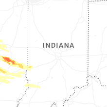
Indiana
| Local Time | Report Details |
|---|---|
| 9:25 AM EDT | Late report of thunderstorm winds damaged at least 4 residences with partial collapses to 2 homes near county road 100 south but no injuries. possible tornado. time est in clay county IN, 62.2 miles E of Mattoon, IL |
| 11:43 AM CDT | A large tree split in half and fell on a hom in la porte county IN, 39.9 miles ESE of Chicago, IL |
| 8:40 PM EDT | Trees were blown down by thunderstorm winds. rough approximation of location. time of occurrence is based on rada in vermillion county IN, 53 miles ENE of Mattoon, IL |
| 9:22 PM EDT | Storm damage reported in vigo county IN, 53.2 miles E of Mattoon, IL |
| 9:36 PM EDT | Trees were blown down by thunderstorm winds. location is a rough approximation. time is based from rada in owen county IN, 44.2 miles WSW of Indianapolis, IN |
| 9:48 PM EDT | Fifteen-inch diameter tree and shingle damage in downtown gospor in owen county IN, 40 miles SW of Indianapolis, IN |
| 9:51 PM EDT | *** 1 inj *** details are unavailable. time estimated from rada in monroe county IN, 38.1 miles SW of Indianapolis, IN |
| 9:54 PM EDT | Corrects previous non-tstm wnd dmg report from 7 sse paragon. reports of damage to vehicles on i-69 near hindusta in monroe county IN, 37.8 miles SSW of Indianapolis, IN |
| 10:06 PM EDT | Trees damage from thunderstorm winds. time is estimated from rada in monroe county IN, 44.8 miles SW of Indianapolis, IN |
| 11:40 PM EDT | Late report of thunderstorm winds downing trees into power lines at us highway 231 and county club road. highway closed in both directions. time estimated from rada in owen county IN, 44.6 miles SW of Indianapolis, IN |
| 11:40 PM EDT | Late report of thunderstorm winds downed multiple trees in owen county. time estimated from rada in owen county IN, 46.7 miles SW of Indianapolis, IN |
| 11:56 PM EDT | Several utility poles snapped and wires downe in ripley county IN, 40.8 miles W of Cincinnati, OH |
| 12:07 AM EDT | Damage of an unspecified nature. time is estimated from rada in jackson county IN, 53.6 miles S of Indianapolis, IN |
| 12:07 AM EDT | Damage of an unspecified nature. time is estimated from rada in jackson county IN, 53.6 miles S of Indianapolis, IN |
| 12:09 AM EDT | Damage occurred on w county road 840 n and n county road 425 w that includes structural and tree damage. a house was flipped over. time is estimated from rada in jackson county IN, 52.9 miles S of Indianapolis, IN |
| 3:02 AM EDT | Tree down at the intersection of south becks mill road and west mitchell roa in washington county IN, 46 miles NNW of Louisville, KY |
Alabama
| Local Time | Report Details |
|---|---|
| 1:20 PM CDT | Dale county 911 call center reported a tree down along county road 404. timing estimated by rada in dale county AL, 82 miles NNE of Miramar Beach, FL |
| 1:20 PM CDT | Dale county 911 call center reported a tree down along will logan road. timing estimated by rada in dale county AL, 82.4 miles NNE of Miramar Beach, FL |
South Dakota
| Local Time | Report Details |
|---|---|
| 3:19 PM CDT | Corrects previous non-tstm wnd gst report from 3 e cavour. mesonet station 211 sd rwis cavou in beadle county SD, 79.2 miles SSE of Aberdeen, SD |
| 3:40 PM CDT | Mesonet station 6 sd rwis forestbur in sanborn county SD, 72.5 miles WNW of Sioux Falls, SD |
| 4:31 PM CDT | Mesonet station 322 sd rwis stanley corne in mccook county SD, 33.1 miles W of Sioux Falls, SD |
| 4:44 PM CDT | Mesonet station 163 sd rwis freema in hutchinson county SD, 39.2 miles WSW of Sioux Falls, SD |
| 5:11 PM CDT | Mesonet station 320 sd rwis iren in turner county SD, 36.6 miles SSW of Sioux Falls, SD |
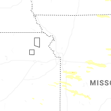
Missouri
| Local Time | Report Details |
|---|---|
| 4:10 PM CDT | Fire dept reports power outages due to trees on power lines. time estimated from rada in randolph county MO, 26.9 miles N of Columbia, MO |
| 4:12 PM CDT | Downed wires near reed street. time estimated from rada in randolph county MO, 32.9 miles N of Columbia, MO |
| 4:14 PM CDT | Quarter sized hail reported near Moberly, MO, 34 miles N of Columbia, MO, report from mping: quarter (1.00 in.). |
| 4:34 PM CDT | Utility company reports power outages. time estimated from rada in pettis county MO, 59 miles W of Columbia, MO |
| 4:35 PM CDT | Utility company reports power outages. time estimated from rada in johnson county MO, 41.1 miles SE of Kansas City, MO |
| 4:57 PM CDT | Utility company reports power outages. time estimated from rada in saline county MO, 39.1 miles W of Columbia, MO |
| 5:00 PM CDT | Several trees and power lines down south and southwest of nelson. time estimated from rada in saline county MO, 40.7 miles W of Columbia, MO |
| 5:01 PM CDT | Hen Egg sized hail reported near Nelson, MO, 38.6 miles W of Columbia, MO, social media report. time and location estimated from radar. |
| 5:04 PM CDT | Utility company reports power outages. time estimated from rada in bates county MO, 55.4 miles S of Kansas City, MO |
| 5:21 PM CDT | Downed wires and power outages near old palestine road. time estimated from rada in cooper county MO, 27.5 miles WSW of Columbia, MO |
| 5:58 PM CDT | Hen Egg sized hail reported near Holden, MO, 43.8 miles SE of Kansas City, MO, report of 2 inch hail. time estimated from radar. |
| 6:29 PM CDT | Downed tree near the intersection of route 127 and route y. time estimated from rada in pettis county MO, 60.6 miles WSW of Columbia, MO |
| 6:33 PM CDT | Several power poles downed on route 127 near route aa. damage to a residence also reported. time estimated from rada in pettis county MO, 61 miles WSW of Columbia, MO |
| 6:36 PM CDT | Social media report of small tree limbs down near rich hill. time estimated from rada in bates county MO, 65.8 miles ENE of Chanute, KS |
| 8:25 PM CDT | Trees down on highway v and o in flemingto in polk county MO, 42.3 miles NNW of Springfield, MO |
Minnesota
| Local Time | Report Details |
|---|---|
| 5:15 PM CDT | Mesonet station mn006 i-90 - beaver creek mp in rock county MN, 18.2 miles ENE of Sioux Falls, SD |
Wisconsin
| Local Time | Report Details |
|---|---|
| 5:39 PM CDT | Small sheds and trees down in boscobel. potential tornado damage. time estimated from rada in grant county WI, 54.4 miles SSE of La Crosse, WI |
| 6:03 PM CDT | Report of multiple trees down with at least one tree snapped at the base along with several other split or large branches down. also home satellite dish ripped off the in iowa county WI, 49.8 miles W of Madison, WI |
| 6:23 PM CDT | Structural damage reported by emergency manager around the ridgeway area. time estimated by rada in iowa county WI, 30.5 miles W of Madison, WI |
| 6:39 PM CDT | Storm damage reported in iowa county WI, 33.3 miles WSW of Madison, WI |
| 6:47 PM CDT | Storm damage reported in dane county WI, 23.2 miles WSW of Madison, WI |
| 7:04 PM CDT | Storm damage reported in dane county WI, 12.8 miles SW of Madison, WI |
| 7:09 PM CDT | Reports of damage to multiple structures and trees on the north side of belleville... wi. time estimated based on rada in dane county WI, 15.4 miles SSW of Madison, WI |
Arizona
| Local Time | Report Details |
|---|---|
| 4:20 PM MST | 4 to 5 power poles reported dow in pima county AZ, 3.6 miles S of Tucson, AZ |
| 4:20 PM MST | Corrects previous tstm wnd dmg report from 4 wsw tucson. 8 power poles reported dow in pima county AZ, 3.1 miles SSE of Tucson, AZ |
Florida
| Local Time | Report Details |
|---|---|
| 7:22 PM EDT | Corrects previous tstm wind gust report from 1 w melbourne beach to marine tstm wind report. the weatherflow station at melbourne south db8 measured a peak wind gust of in amz552 county FL, 56.4 miles NNW of Port Saint Lucie, FL |
New Mexico
| Local Time | Report Details |
|---|---|
| 5:31 PM MDT | Asos station kdmn deming aso in luna county NM, 47.3 miles SE of Silver City, NM |
| 6:35 PM MDT | Awos station ksvc grant county airport awo in grant county NM, 12.1 miles SE of Silver City, NM |
| 7:25 PM MDT | Mesonet station nm008 lordsburg playa i10 mp7 (nmdot in hidalgo county NM, 52.4 miles SW of Silver City, NM |
Texas
| Local Time | Report Details |
|---|---|
| 6:33 PM MDT | Asos station kelp el paso international airpor in el paso county TX, 7.6 miles NE of El Paso, TX |
| 6:36 PM MDT | Asos station kbif biggs field awo in el paso county TX, 8.9 miles NE of El Paso, TX |
Ohio
| Local Time | Report Details |
|---|---|
| 10:15 PM EDT | Large tree snappe in allen county OH, 46.6 miles ESE of Fort Wayne, IN |
| 10:45 PM EDT | Multiple trees downed. some fell onto power lines and reportedly smashed three cars. near the intersection of columbus grove rd and tom fett rd. tree in photo sent appe in allen county OH, 63 miles ESE of Fort Wayne, IN |
| 11:36 PM EDT | Multiple trees dow in seneca county OH, 74.4 miles N of Columbus, OH |
| 11:53 PM EDT | Delayed report of a downed tre in crawford county OH, 68.3 miles N of Columbus, OH |
| 12:29 AM EDT | Delayed report of a tree dow in lorain county OH, 23.7 miles SW of Cleveland, OH |
| 3:24 AM EDT | Tree in westbound lane reported as blocking both lanes... u.s. route 50 at dow lake. time estimated from rada in athens county OH, 67.8 miles NNW of Charleston, WV |
| 5:15 AM EDT | Trees dow in adams county OH, 56.6 miles ESE of Cincinnati, OH |
| 5:19 AM EDT | Trees dow in adams county OH, 59.9 miles E of Cincinnati, OH |
| 5:33 AM EDT | Occupied vehicle in high water at crosscreek general store on route 50 in richland townshi in vinton county OH, 52.6 miles SSE of Columbus, OH |
| 5:55 AM EDT | Trees down in and near ironto in lawrence county OH, 58.3 miles WNW of Charleston, WV |
| 6:51 AM EDT | Several trees down on power line in ashtabula county OH, 41.9 miles ENE of Cleveland, OH |
Kentucky
| Local Time | Report Details |
|---|---|
| 12:37 AM EDT | Asos station kcvg cincinnati/northern kentucky international airpor in boone county KY, 10 miles WSW of Cincinnati, OH |
| 12:39 AM EDT | Damage to the siding on a commercial building was reporte in boone county KY, 11.4 miles SW of Cincinnati, OH |
| 12:40 AM EDT | A large tree was downed and struck an apartment building... causing moderate structural damage. tornado possibl in boone county KY, 11.6 miles SW of Cincinnati, OH |
| 12:40 AM EDT | A roof sustained damage. tornado possibl in boone county KY, 10.9 miles SW of Cincinnati, OH |
| 12:40 AM EDT | A roof sustained damage. tornado possibl in boone county KY, 11.2 miles SW of Cincinnati, OH |
| 12:41 AM EDT | Multiple trees downed along with several large tree limbs. tornado possibl in boone county KY, 11.6 miles SW of Cincinnati, OH |
| 12:42 AM EDT | A tree was downed onto a residential home. tornado possibl in boone county KY, 10.5 miles SW of Cincinnati, OH |
| 3:42 AM EDT | Damage throughout carrollton... including downed trees and a snapped power pol in carroll county KY, 46.8 miles SW of Cincinnati, OH |
| 3:43 AM EDT | Power poles damaged with widespread tree damage. power pole damage concentrated in the 2500 to 2700 block of highland avenue. time estimated from rada in carroll county KY, 44.7 miles SW of Cincinnati, OH |
| 3:50 AM EDT | Kentucky mesonet site crr in carroll county KY, 44.7 miles SW of Cincinnati, OH |
| 4:02 AM EDT | Awos site k8gk gallatin county airpor in gallatin county KY, 37.3 miles SW of Cincinnati, OH |
| 4:10 AM EDT | Measured by the shelby county north mesonet statio in shelby county KY, 38 miles NE of Louisville, KY |
| 4:20 AM EDT | Trees down... power lines down... minor damage to homes. time taken from the calle in grant county KY, 32.4 miles S of Cincinnati, OH |
| 4:40 AM EDT | Power lines/ wires dow in oldham county KY, 25.8 miles NNE of Louisville, KY |
| 4:52 AM EDT | A tree was reported to have been blown down onto ewing road in the fairview community. the event time is radar estimate in fleming county KY, 52.5 miles N of Irvine, KY |
| 5:02 AM EDT | Structural damage and multiple trees down by east maple leaf road and wal-mart wa in mason county KY, 51.5 miles SE of Cincinnati, OH |
| 5:05 AM EDT | Multiple trees down across escondida road. time estimated from rada in bourbon county KY, 31.8 miles NNW of Irvine, KY |
| 5:18 AM EDT | A tree was reported to have been blown down at 1700 grassy lick road blocking the entire roadway. the event time is radar estimate in montgomery county KY, 25.5 miles N of Irvine, KY |
| 5:20 AM EDT | Trees were reported to have been blown down in owingsville. the event time is radar estimate in bath county KY, 32.5 miles NNE of Irvine, KY |
| 5:25 AM EDT | Trees were reported to have been blown down down on sour springs road. the event time is radar estimate in bath county KY, 29.9 miles NNE of Irvine, KY |
| 5:26 AM EDT | Trees were reported to have been blown down along us 60 near the rowan and bath county line. the event time is radar estimate in rowan county KY, 38.2 miles NE of Irvine, KY |
| 5:27 AM EDT | Multiple trees were blown down onto and in areas near ky 519 between morehead and clearfield. portions of ky 519 were closed due to debris. the event time is radar esti in rowan county KY, 43.5 miles NE of Irvine, KY |
| 5:27 AM EDT | Trees were reported down on fraley road and other locations in the salt lick vicinity. the event time is radar estimate in bath county KY, 35.8 miles NE of Irvine, KY |
| 5:33 AM EDT | Tree down on state highway 8 near quincy blocking the entire roadway. time estimated from rada in greenup county KY, 79.7 miles WNW of Charleston, WV |
| 5:38 AM EDT | Trees were reported down on ky 519 near or just north of the morgan county line. the event time is radar estimate in rowan county KY, 40 miles NE of Irvine, KY |
| 5:45 AM EDT | Tree down across hwy 78 in greenup county KY, 79.3 miles NE of Irvine, KY |
| 5:50 AM EDT | Tree down on roadwa in greenup county KY, 60.6 miles WNW of Charleston, WV |
West Virginia
| Local Time | Report Details |
|---|---|
| 4:35 AM EDT | Tree down blocking one lane on staunton turnpike near bear run in petroleum. time estimated from rada in ritchie county WV, 56.8 miles NNE of Charleston, WV |
| 5:43 AM EDT | A tree was reported down over powerline in monongalia county WV, 50.8 miles N of Elkins, WV |
| 6:30 AM EDT | Multiple trees down including mt altro... jack burlingam rd and schoolhouse ru in jackson county WV, 38.3 miles NNW of Charleston, WV |
| 6:35 AM EDT | Several trees down near ravenswood including kenwood ln and pt pleasant r in jackson county WV, 38.5 miles N of Charleston, WV |
| 6:40 AM EDT | Tree and power lines down on spencer r in jackson county WV, 31.7 miles N of Charleston, WV |
| 6:40 AM EDT | Several trees down in northern mingo county including stonecoal rd... low gap hollow rd... jennies creek rd... and messenger branc in mingo county WV, 47.7 miles SW of Charleston, WV |
| 7:30 AM EDT | Multiple trees down in and around rock cave with one reported down on a hous in upshur county WV, 26.1 miles W of Elkins, WV |
Louisiana
| Local Time | Report Details |
|---|---|
| 4:28 AM CDT | Roof damage to a home on evelyn avenue on the east side of houm in terrebonne county LA, 44.9 miles SW of New Orleans, LA |
| 5:40 AM CDT | Trained spotter reported minor sign... powerline and tree damage from possible tornado crossing the mississippi river near waggama in jefferson county LA, 8.1 miles WSW of New Orleans, LA |
| 5:45 AM CDT | Trained spotter reported minor sign... powerline and tree damage over portions of metairie from possible tornad in jefferson county LA, 5 miles WNW of New Orleans, LA |
| 5:46 AM CDT | Large tree limb downed by thunderstorm winds... possible tornado... in lakeview are in orleans county LA, 4.3 miles NNW of New Orleans, LA |
| 5:50 AM CDT | Trained spotter reported minor sign... powerline and tree damage near the lakefront from possible tornad in jefferson county LA, 5.9 miles NW of New Orleans, LA |
| 6:00 AM CDT | Multiple broadcast media reported power flashes across metairie area. possible tornad in jefferson county LA, 5.1 miles WNW of New Orleans, LA |
| 6:08 AM CDT | The lakefront airport knew measured a thunderstorm wind gust of 58 knots or 67 mp in orleans county LA, 7.2 miles NNE of New Orleans, LA |
| 6:28 AM CDT | Report of powerlines... building... and tree damage between airline and earhart around l and a r in jefferson county LA, 4.5 miles WNW of New Orleans, LA |
Connect with Interactive Hail Maps