

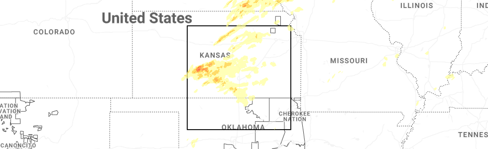
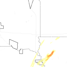
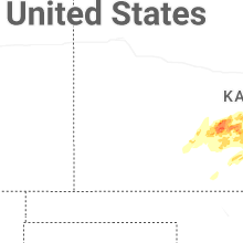
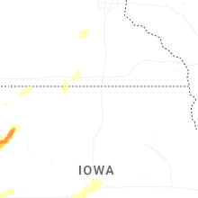
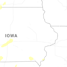
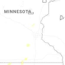
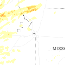
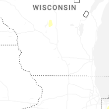
Hail Map for Monday, May 18, 2026
Number of Impacted Households on 5/18/2026
0
Impacted by 1" or Larger Hail
0
Impacted by 1.75" or Larger Hail
0
Impacted by 2.5" or Larger Hail
Square Miles of Populated Area Impacted on 5/18/2026
0
Impacted by 1" or Larger Hail
0
Impacted by 1.75" or Larger Hail
0
Impacted by 2.5" or Larger Hail


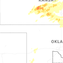
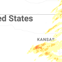
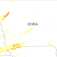
Cities Most Affected by Hail Storms of 5/18/2026
| Hail Size | Demographics of Zip Codes Affected | ||||||
|---|---|---|---|---|---|---|---|
| City | Count | Average | Largest | Pop Density | House Value | Income | Age |
| Lincoln, KS | 2 | 1.88 | 2.00 | 6 | $37k | $31.8k | 44.7 |
| Sheridan, MO | 1 | 2.75 | 2.75 | 6 | $21k | $24.3k | 45.4 |
| Haviland, KS | 1 | 2.00 | 2.00 | 2 | $37k | $32.2k | 39.3 |
| Inman, KS | 1 | 2.00 | 2.00 | 12 | $84k | $41.3k | 45.4 |
| Kinsley, KS | 1 | 1.75 | 1.75 | 6 | $38k | $29.5k | 45.5 |
| Skidmore, MO | 1 | 1.75 | 1.75 | 5 | $23k | $27.7k | 44.9 |
| Correctionville, IA | 1 | 1.75 | 1.75 | 9 | $54k | $32.2k | 45.3 |
| Burlington Junction, MO | 1 | 1.75 | 1.75 | 7 | $39k | $31.3k | 41.7 |
| Offerle, KS | 1 | 1.75 | 1.75 | 4 | $32k | $40.3k | 45.9 |
| Brock, NE | 1 | 1.75 | 1.75 | 6 | $39k | $30.2k | 48.2 |
| Pilger, NE | 1 | 1.75 | 1.75 | 6 | $52k | $33.2k | 46.9 |
| Pickrell, NE | 1 | 1.75 | 1.75 | 7 | $69k | $35.1k | 44.4 |
| Milligan, NE | 1 | 1.75 | 1.75 | 4 | $41k | $26.6k | 47.5 |
| Clarkson, NE | 1 | 1.75 | 1.75 | 5 | $43k | $31.5k | 45.9 |
| Argonia, KS | 1 | 1.75 | 1.75 | 5 | $42k | $35.1k | 41.1 |
| Friend, NE | 1 | 1.75 | 1.75 | 12 | $73k | $35.6k | 45.3 |
Hail and Wind Damage Spotted on 5/18/2026
Filter by Report Type:Hail ReportsWind Reports
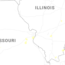
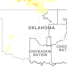
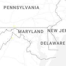
States Impacted
Missouri, Illinois, Indiana, Michigan, Kansas, Nebraska, West Virginia, Ohio, Virginia, Maryland, Iowa, Oklahoma, PennsylvaniaMissouri
| Local Time | Report Details |
|---|---|
| 7:38 AM CDT | Relayed from social media: tree blocking highway 47 at big creek north of warrenton. time estimated from rada in warren county MO, 53.2 miles WNW of Saint Louis, MO |
| 5:05 PM CDT | Pws measured multiple wind gusts over 60 mph... including peak 75 mp in atchison county MO, 56.9 miles SSE of Omaha, NE |
| 5:05 PM CDT | Public relayed 60 mph winds with initial storms moving through. time estimated from rada in atchison county MO, 63.8 miles SSE of Omaha, NE |
| 5:58 PM CDT | Golf Ball sized hail reported near Skidmore, MO, 76.8 miles SE of Omaha, NE, em relayed spotter reported golf ball sized hail. |
| 6:17 PM CDT | Golf Ball sized hail reported near Burlington Junction, MO, 76.8 miles SE of Omaha, NE, social media report. time estimated from radar. |
| 6:18 PM CDT | Ping Pong Ball sized hail reported near Maryville, MO, 80.1 miles SE of Omaha, NE, mo sema employee reported ping pong ball size hail. |
| 6:48 PM CDT | Downed wires near route u. time confirmed from rada in atchison county MO, 65.9 miles SSE of Omaha, NE |
| 7:00 PM CDT | Baseball sized hail reported near Sheridan, MO, 86.4 miles SE of Omaha, NE, em relayed pictures of hail next to ruler. largest greater than 2.5 inches in diameter. |
| 7:01 PM CDT | Ping Pong Ball sized hail reported near Sheridan, MO, 87.3 miles SE of Omaha, NE, hail up to ping pong in size. |
| 7:08 PM CDT | Multiple reports of downed wires west of fairfax. time estimated from rada in atchison county MO, 69.1 miles SSE of Omaha, NE |
| 7:29 PM CDT | Quarter sized hail reported near Grant City, MO, 86.7 miles SSW of Des Moines, IA, report from mping: quarter (1.00 in.). time estimated from radar. |
| 8:05 PM CDT | Downed wires and power outages near riverbreaks conservation area. time estimated from rada in holt county MO, 63.2 miles NNW of Kansas City, MO |
| 8:13 PM CDT | Kstj asos recorded 61 mph wind gus in buchanan county MO, 49.2 miles NNW of Kansas City, MO |
| 8:14 PM CDT | Several trees blown down in fillmore. time estimated from rada in andrew county MO, 67.2 miles NNW of Kansas City, MO |
| 8:22 PM CDT | Several reports of downed trees and wires and property damage on county road 191. time estimated from rada in andrew county MO, 59.6 miles N of Kansas City, MO |
| 8:22 PM CDT | Downed trees and wires in bolckow. time estimated from rada in andrew county MO, 70.6 miles N of Kansas City, MO |
| 8:31 PM CDT | Pws measured 58 mph gus in dekalb county MO, 48.8 miles N of Kansas City, MO |
| 8:33 PM CDT | Pws measured 65 mph gus in nodaway county MO, 71.7 miles N of Kansas City, MO |
| 8:37 PM CDT | Social media report of a barn roof blown off. time estimated from rada in dekalb county MO, 64.7 miles N of Kansas City, MO |
| 8:37 PM CDT | Several reports of downed wires northwest of king city. time estimated from rada in andrew county MO, 67.5 miles N of Kansas City, MO |
| 8:37 PM CDT | Several reports of downed tree limbs and wires in st. joseph. time estimated from rada in buchanan county MO, 48.2 miles NNW of Kansas City, MO |
| 8:43 PM CDT | Pws measured gus in gentry county MO, 80.6 miles N of Kansas City, MO |
| 8:48 PM CDT | Downed wires near lakesite road. time estimated from rada in dekalb county MO, 56 miles N of Kansas City, MO |
| 8:55 PM CDT | Downed wires near elm road. time estimated from rada in dekalb county MO, 52.9 miles NNE of Kansas City, MO |
| 9:01 PM CDT | Social media reports of downed tree limbs and wires near pattonsburg. time estimated from rada in daviess county MO, 71.3 miles NNE of Kansas City, MO |
| 9:07 PM CDT | Measured from handheld anemomete in buchanan county MO, 47.1 miles NNW of Kansas City, MO |
| 9:18 PM CDT | Report of 60 mph gust relayed from e in platte county MO, 8.5 miles NW of Kansas City, MO |
| 9:24 PM CDT | Em relayed public report of 70 mph wind gus in harrison county MO, 81 miles NNE of Kansas City, MO |
| 9:27 PM CDT | Report of 65 mph wind gus in jackson county MO, 4.4 miles SSW of Kansas City, MO |
| 9:29 PM CDT | Downtown kansas city ap measured 64 mph wind gust in clay county MO, 1.2 miles NNW of Kansas City, MO |
| 9:29 PM CDT | Pws measured 65 mph wind gus in jackson county MO, 1 miles SSW of Kansas City, MO |
| 9:29 PM CDT | Several trees down... including one through a house. time estimated from rada in clay county MO, 5.4 miles NNE of Kansas City, MO |
| 9:30 PM CDT | Pws measured 59 mph wind gus in jackson county MO, 0.7 miles ESE of Kansas City, MO |
| 9:30 PM CDT | Downed tree branch on overheard wires of streetcar... suspending service. time estimated from rada in jackson county MO, 0.5 miles NNE of Kansas City, MO |
| 9:32 PM CDT | Blown transformer and power lines down in gladstone. time estimated from rada in clay county MO, 9.2 miles NNE of Kansas City, MO |
| 9:35 PM CDT | Downed trees and limbs west of i-35 and route 291. time estimated from rada in clay county MO, 13.3 miles NNE of Kansas City, MO |
| 9:35 PM CDT | Social media report. snapped tree on 39th street. time estimated from rada in jackson county MO, 3 miles S of Kansas City, MO |
| 9:35 PM CDT | Tree partially over stadium driv in jackson county MO, 6.3 miles ESE of Kansas City, MO |
| 9:35 PM CDT | Several trees down near 44th street. time estimated from rada in jackson county MO, 3.7 miles S of Kansas City, MO |
| 9:36 PM CDT | Law enforcement measured a 63 mph wind gus in clay county MO, 21.7 miles NE of Kansas City, MO |
| 9:37 PM CDT | Large tree down on truman road east of i-435. time estimated from rada in jackson county MO, 5.6 miles E of Kansas City, MO |
| 9:40 PM CDT | Large tree downed near 84th and laurel. time estimated from rada in jackson county MO, 10.7 miles SSE of Kansas City, MO |
| 9:43 PM CDT | Multiple social media reports of trees down in independence. time estimated from rada in jackson county MO, 8.8 miles E of Kansas City, MO |
| 9:45 PM CDT | Pws measured 66 mph wind gus in jackson county MO, 12.1 miles ENE of Kansas City, MO |
| 9:46 PM CDT | Large tree limbs down and a fence blown over. winds estimated at 80 mph. time estimated from rada in cass county MO, 21.6 miles SSE of Kansas City, MO |
| 9:46 PM CDT | Large tree limbs down and a fence blown over. winds estimated at 80 mph. time estimated from rada in cass county MO, 21.6 miles SSE of Kansas City, MO |
| 9:49 PM CDT | Lees summit municipal airport measured a 58 mph wind gus in jackson county MO, 15.1 miles SE of Kansas City, MO |
| 9:51 PM CDT | Two large tree limbs downed at a residence. time estimated from rada in clay county MO, 25 miles NE of Kansas City, MO |
| 9:51 PM CDT | Large tree down at a residence west of buckner. time estimated from rada in jackson county MO, 15.9 miles E of Kansas City, MO |
| 10:01 PM CDT | Downed tree at a residence southwest of richmond. time estimated from rada in ray county MO, 33.1 miles ENE of Kansas City, MO |
| 10:04 PM CDT | Downed trees and power poles near and north of richmond. time estimated from rada in ray county MO, 35.1 miles ENE of Kansas City, MO |
| 10:07 PM CDT | Reports of downed wires east of pleasant hill. time estimated from rada in cass county MO, 28.4 miles SE of Kansas City, MO |
| 10:16 PM CDT | Several reports of downed wires and widespread power outages between hamilton and breckenridge. time estimated from rada in caldwell county MO, 58.2 miles NE of Kansas City, MO |
| 10:28 PM CDT | Downed wires and power outages near county road 201. time estimated from rada in carroll county MO, 55.5 miles ENE of Kansas City, MO |
| 10:36 PM CDT | Social media video of power flashes and downed power lines in carrollton. time estimated from rada in carroll county MO, 60.8 miles ENE of Kansas City, MO |
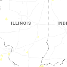
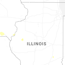
Illinois
| Local Time | Report Details |
|---|---|
| 7:56 AM CDT | Delayed report from social media. significant tree damage at the cemetery on the north side of virginia. time estimated from rada in cass county IL, 60.3 miles SSW of Peoria, IL |
| 8:12 AM CDT | Irrigation system flipped ove in mason county IL, 30.7 miles SW of Peoria, IL |
| 8:23 AM CDT | Power pole down across the road near spring lak in tazewell county IL, 16.5 miles SW of Peoria, IL |
| 8:23 AM CDT | Large tree on power line. power lines dow in tazewell county IL, 18.9 miles SW of Peoria, IL |
| 8:26 AM CDT | Corrects time of previous tstm wnd dmg report from 4 ssw kingston mines. power pole down across the road near spring lak in tazewell county IL, 16.5 miles SW of Peoria, IL |
| 8:38 AM CDT | Tree on a house in pekin. delayed report... time estimated from rada in tazewell county IL, 8.2 miles SSW of Peoria, IL |
| 8:58 AM CDT | 3.5-4 foot diameter tree fell... blocking stringtown rd. near hopedale. delayed repor in tazewell county IL, 21.1 miles SSE of Peoria, IL |
| 9:02 AM CDT | Large tree limbs dow in christian county IL, 36.7 miles W of Mattoon, IL |
| 9:07 AM CDT | Multiple reports of large tree limbs down around litchfiel in montgomery county IL, 47.9 miles NE of Saint Louis, MO |
| 9:09 AM CDT | Trees... large limbs... and power lines reported down in litchfield. time estimated from rada in montgomery county IL, 47.9 miles NE of Saint Louis, MO |
| 9:10 AM CDT | Tree damage reported in buffalo. time estimated by rada in sangamon county IL, 58.9 miles S of Peoria, IL |
| 9:15 AM CDT | Tree fell across road. delayed repor in tazewell county IL, 22.7 miles SE of Peoria, IL |
| 9:15 AM CDT | Measured gust to 58 mph at woodford county eo in woodford county IL, 21.4 miles ENE of Peoria, IL |
| 9:40 AM CDT | Storm damage reported in christian county IL, 51.1 miles W of Mattoon, IL |
| 9:40 AM CDT | Quarter sized hail reported near Lerna, IL, 6.2 miles SE of Mattoon, IL, delayed report. time estimated from radar. |
| 10:10 AM CDT | Tree uproote in coles county IL, 20.2 miles ENE of Mattoon, IL |
| 10:28 AM CDT | Paxton ema shared photos of multiple power poles broken and a nearby outbuilding damaged just north of 1500 east road and 100 north road. debris blown across 1500 east in ford county IL, 64.9 miles N of Mattoon, IL |
| 10:35 AM CDT | Public report of large branch broken and blocking a street near east aurora high school. time estimated by rada in kane county IL, 35.9 miles WSW of Chicago, IL |
| 10:45 AM CDT | Kankakee county ema reports widely scattered tree limbs broken in and near kankakee. time estimated by rada in kankakee county IL, 54 miles SSW of Chicago, IL |
| 10:55 AM CDT | Kankakee airport kikk awos reported 58 mph wind gust from the wes in kankakee county IL, 57.3 miles SSW of Chicago, IL |
| 10:55 AM CDT | Trained spotter reports a few 3-4 inch diameter branches downed in homewood. time estimated by rada in cook county IL, 22.4 miles S of Chicago, IL |
| 10:58 AM CDT | Power line downed near 56th street and south sayre avenue in garfield ridge community area of chicago. time estimated by rada in cook county IL, 10.8 miles SW of Chicago, IL |
| 10:58 AM CDT | Tree branch broken and fell onto car near 54th street and south normandy avenue in garfield ridge community area of chicago. time estimated by rada in cook county IL, 10.4 miles SW of Chicago, IL |
| 10:59 AM CDT | Tree or tree branch broken... blocking southbound lane of troy street near 106th street in mount greenwood community area of chicago. time estimated by rada in cook county IL, 13.2 miles SSW of Chicago, IL |
| 11:00 AM CDT | Tree or tree branch broken... blocking traffic near tripp avenue and 52nd street in archer heights community area of chicago. time estimated by rada in cook county IL, 7.7 miles SW of Chicago, IL |
| 11:01 AM CDT | Kmdw asos recorded 79 mph wind gust from the southwes in cook county IL, 8.9 miles SW of Chicago, IL |
| 11:03 AM CDT | A few public reports of tree branches broken in the roseland community area of chicago. relayed by chicago 311. time estimated by rada in cook county IL, 11.3 miles S of Chicago, IL |
| 11:07 AM CDT | A few public reports of tree branches broken in the south chicago community area of chicago. relayed via chicago 311. time estimated by rada in cook county IL, 10.8 miles SSE of Chicago, IL |
| 11:07 AM CDT | Large branched downed on roadway near 103rd street and avenue l in east side community area of chicago. time estimated by rada in cook county IL, 12.9 miles SSE of Chicago, IL |
| 11:09 AM CDT | Power line downed near jackson boulevard and morgan street in near west side community area of chicago. time estimated by rada in cook county IL, 1 miles WSW of Chicago, IL |
| 11:09 AM CDT | Tree branch broken onto roadway near erie street and ashland avenue in west town community area of chicago. time estimated by rada in cook county IL, 2 miles WNW of Chicago, IL |
| 11:14 AM CDT | Tree or tree branch broken and blocking roadway near cornelia avenue and fremont street in lakeview community area of chicago. time estimated by rada in cook county IL, 4.6 miles N of Chicago, IL |
| 11:14 AM CDT | Harrison-dever crib recorded 50 knot wind gus in lmz741 county IL, 4.1 miles NE of Chicago, IL |
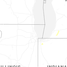
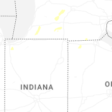
Indiana
| Local Time | Report Details |
|---|---|
| 11:13 AM CDT | Gary airport asos gys reported 58 mph wind gust from the sout in lake county IN, 21.5 miles SSE of Chicago, IL |
| 11:21 AM CDT | Corrects previous report from 1 sse hobart to tstm wind. public report of 65 mph gust recorded by backyard weather station near linda street and 10th street in hobar in lake county IN, 32 miles SE of Chicago, IL |
| 11:29 AM CDT | Quarter sized hail reported near Hebron, IN, 39.4 miles SE of Chicago, IL, public report of 1.0 inch hail east of winfield. time estimated by radar. |
| 11:40 AM CDT | Private weather station 1.5 miles north of kouts reported 60 mph gus in porter county IN, 49.2 miles SE of Chicago, IL |
| 11:44 AM CDT | Michigan city cman station reported 54 kt gus in lmz745 county IN, 37.8 miles ESE of Chicago, IL |
| 11:45 AM CDT | Emergency manager reports several trees and large branches downed including a couple large limbs down onto houses. no injuries reported. time estimated by rada in la porte county IN, 49.6 miles SE of Chicago, IL |
| 12:00 PM CDT | Tree down across long lane and us 6 near union mills. time estimated via rada in la porte county IN, 51.6 miles ESE of Chicago, IL |
| 12:05 PM CDT | Several reports of trees down in la porte in vicinity and heading into la porte... in on us route 35. time estimated from rada in la porte county IN, 52.3 miles ESE of Chicago, IL |
| 12:07 PM CDT | Large tree branches downed. time estimated from rada in la porte county IN, 50.8 miles ESE of Chicago, IL |
| 1:15 PM EDT | Tree downed by thunderstorm wind gust in parke county IN, 61.5 miles ENE of Mattoon, IL |
| 1:15 PM EDT | Powerlines downed by thunderstorm wind gust in parke county IN, 58 miles W of Indianapolis, IN |
| 1:16 PM EDT | Media report of large tree snapped in half near new carlisle in st. joseph county in indiana. time estimated by rada in st. joseph county IN, 58.7 miles ESE of Chicago, IL |
| 1:18 PM EDT | Tree downed by thunderstorm wind gust in parke county IN, 59.7 miles ENE of Mattoon, IL |
| 1:23 PM EDT | Three power poles downed by thunderstorm wind gust in clay county IN, 61.3 miles WSW of Indianapolis, IN |
| 1:31 PM EDT | Media report of a large tree downed onto a vehicle by a thunderstorm wind gust near intersection of humboldt street and cleveland avenue in south bend... in st. joseph in st. joseph county IN, 71.6 miles E of Chicago, IL |
| 1:31 PM EDT | Large tree downed on notre dame campus. time estimate from rada in st. joseph county IN, 72.3 miles E of Chicago, IL |
| 1:31 PM EDT | Large trees branches downed near eddy st. and jefferson blvd. time estimated from rada in st. joseph county IN, 72.5 miles NW of Fort Wayne, IN |
| 1:31 PM EDT | Pictures relayed by ema of a pole barn suffering damage to several walls and the roof as well as a tree down in the area. location along w 100 s... between s 200 and s in fulton county IN, 62.3 miles W of Fort Wayne, IN |
| 1:34 PM EDT | Large tree branches downed near gumwood and brock road. time estimated by rada in st. joseph county IN, 72.5 miles NW of Fort Wayne, IN |
| 1:34 PM EDT | Large tree downed by thunderstorm wind gusts. delayed report. time estimated from rada in putnam county IN, 42.3 miles WSW of Indianapolis, IN |
| 1:36 PM EDT | Photon facebook showing a large tree uprooted (estimated 18-24 inches in diameter) in rochester. time estimated via rada in fulton county IN, 58.5 miles W of Fort Wayne, IN |
| 1:37 PM EDT | Media reported large branch down near granger in st. joseph county in indiana. time estimated by rada in st. joseph county IN, 70.2 miles NW of Fort Wayne, IN |
| 1:38 PM EDT | Large tree branches downed. time estimated from rada in st. joseph county IN, 72.9 miles NW of Fort Wayne, IN |
| 1:40 PM EDT | Large branches downed. time estimated from rada in st. joseph county IN, 70.9 miles NW of Fort Wayne, IN |
| 1:40 PM EDT | Large tree down on quail ridge south. time estimated from rada in st. joseph county IN, 72.9 miles NW of Fort Wayne, IN |
| 1:43 PM EDT | Multiple trees downed near intersection of grape and brick road. time estimated from rada in st. joseph county IN, 72.9 miles NW of Fort Wayne, IN |
| 1:43 PM EDT | Large tree downed on hickory road. time estimated from rada in st. joseph county IN, 72.9 miles NW of Fort Wayne, IN |
| 1:43 PM EDT | Media reported a large tree snapped along with other branches near osceola in st. joseph county indiana. time is radar estimate in st. joseph county IN, 65.4 miles NW of Fort Wayne, IN |
| 1:45 PM EDT | Significant number of trees and powerlines downed in the count in owen county IN, 45.6 miles WSW of Indianapolis, IN |
| 1:50 PM EDT | Large tree downed. time estimated from rada in st. joseph county IN, 69.2 miles NW of Fort Wayne, IN |
| 1:50 PM EDT | Outbuilding damaged north of mentone on sr 19. time estimated via rada in kosciusko county IN, 50.2 miles W of Fort Wayne, IN |
| 1:50 PM EDT | Powerlines down near the intersection of ash rd and jefferson rd. time estimated via rada in elkhart county IN, 65.1 miles NW of Fort Wayne, IN |
| 2:13 PM EDT | Large tree branches downed near ferry and anna streets. time estimated from rada in wabash county IN, 42.4 miles WSW of Fort Wayne, IN |
| 2:16 PM EDT | Large tree downed onto a house on west main street. time estimated from rada in wabash county IN, 42.7 miles WSW of Fort Wayne, IN |
| 2:18 PM EDT | Several trees and powerlines down in the count in morgan county IN, 26.8 miles WSW of Indianapolis, IN |
| 2:19 PM EDT | Large tree limbs downed on north maple street. time estimated from rada in wabash county IN, 42.7 miles WSW of Fort Wayne, IN |
| 2:25 PM EDT | Tree down on n 1150 w at stone lake north of middlebury. time estimated via rada in lagrange county IN, 54.1 miles NNW of Fort Wayne, IN |
| 2:29 PM EDT | Mping report of trees damaged by wind estimated at 60 mp in boone county IN, 15.5 miles NNW of Indianapolis, IN |
| 2:35 PM EDT | Indianapolis executive airport measured a wind gust of 61 mp in boone county IN, 18.9 miles NNW of Indianapolis, IN |
| 2:45 PM EDT | Spotter reports measured thunderstorm wind gust of 61 mph just southwest of blue lake in whitley county in indian in whitley county IN, 17.3 miles NW of Fort Wayne, IN |
| 2:45 PM EDT | 60 mph winds reported at the huntington county ema office. time estimated via rada in huntington county IN, 25.8 miles WSW of Fort Wayne, IN |
| 2:47 PM EDT | Emergency manager report of tree blown down across ruckman road near old trail road about 6 miles east of columbia city in whitley county in indiana. time estimated by in whitley county IN, 15.8 miles WNW of Fort Wayne, IN |
| 3:15 PM EDT | Emergency manager report of powerlines downed in hamilton in steuben county in indiana. time is estimated by rada in steuben county IN, 32.9 miles NNE of Fort Wayne, IN |
| 3:22 PM EDT | Emergency manager report of tree downed across roadway on cr 800e just south of us-20 just north of metz in steuben county in indiana. time is estimated by rada in steuben county IN, 40.6 miles NNE of Fort Wayne, IN |
| 3:59 PM CDT | Delayed report. trees and power lines down over mount pleasant road to the east of darmstadt roa in vanderburgh county IN, 5.7 miles N of Evansville, IN |
| 5:45 PM EDT | Large tree blocking roadwa in dubois county IN, 55.4 miles ENE of Evansville, IN |
| 6:00 PM EDT | Several trees down in the roadwa in dubois county IN, 44 miles ENE of Evansville, IN |
| 6:50 PM EDT | Trees down around the county and along sr 160 near salem. one tree fell on a vehicle on carolyn dr. but no injuries were reporte in washington county IN, 46.4 miles NNW of Louisville, KY |
| 7:00 PM EDT | Tree on power line on 22000 block of campbell st in clark county IN, 42.3 miles N of Louisville, KY |
| 7:00 PM EDT | Tree on power line on speith r in clark county IN, 38.4 miles N of Louisville, KY |
| 7:10 PM EDT | Reports of several trees down along state road 160 near the intersections of s franklin school road and s conway church roa in washington county IN, 42.9 miles NNW of Louisville, KY |
| 7:11 PM EDT | Large tree in the roadway... blocking the entire road. chain saws neede in dubois county IN, 51.4 miles ENE of Evansville, IN |
| 7:31 PM EDT | Report of trees down near the intersection of sr 160 and s casey rd west of henryville... i in clark county IN, 40.1 miles N of Louisville, KY |
| 7:39 PM EDT | Trees down on east blue river roa in washington county IN, 39.2 miles NNW of Louisville, KY |
| 7:40 PM EDT | Tree and power lines downed on state route 14 in dearborn county IN, 21.9 miles W of Cincinnati, OH |
| 7:50 PM EDT | Tree down on residential property on cedarwood d in jefferson county IN, 53.1 miles WSW of Cincinnati, OH |
| 7:54 PM EDT | Reports of trees down along north franklin bottoms r in washington county IN, 51.5 miles N of Louisville, KY |
| 8:05 PM EDT | Reports of trees down along s eastern school rd... nne of new pekin... i in washington county IN, 39.8 miles NNW of Louisville, KY |
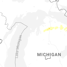
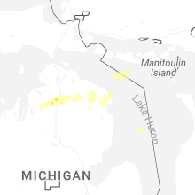
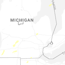
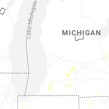
Michigan
| Local Time | Report Details |
|---|---|
| 1:14 PM EDT | Weatherflow station xstj at st joe pier reported a 60 mph wind gus in lmz043 county MI, 60.3 miles ENE of Chicago, IL |
| 1:14 PM EDT | Mesonet station xstj st. joseph pie in lmz844 county MI, 61 miles ENE of Chicago, IL |
| 1:25 PM EDT | Asos station kbeh benton harbo in berrien county MI, 64.7 miles ENE of Chicago, IL |
| 1:34 PM EDT | Delayed report. large tree limbs downed on ferry street. time estimated from rada in berrien county MI, 71.9 miles E of Chicago, IL |
| 1:35 PM EDT | Emergency manager reports powerlines and power pole down near freese road and roys road to the northeast of constantine in st. joseph county in michigan. time estimated in st. joseph county MI, 61.8 miles NNW of Fort Wayne, IN |
| 1:41 PM EDT | Mdot station mc099 at south have in van buren county MI, 48.4 miles SW of Grand Rapids, MI |
| 1:46 PM EDT | Irrigation pivot flipped over. time estimated from rada in cass county MI, 72.1 miles NW of Fort Wayne, IN |
| 1:48 PM EDT | Large tree downed onto eagle lake road. time estimated from rada in cass county MI, 68.7 miles NW of Fort Wayne, IN |
| 1:50 PM EDT | Damage reported at the edwardsburg little league fields. two dugout roofs were blown off... several fences damaged... and some damage to the bleachers. time estimated v in cass county MI, 71.3 miles NW of Fort Wayne, IN |
| 1:54 PM EDT | 911 dispatch reports numerous trees and wires down across van buren county. time estimated via rada in van buren county MI, 52.8 miles SSW of Grand Rapids, MI |
| 2:00 PM EDT | Large trees downed in vandalia area. time estimated from rada in cass county MI, 71.9 miles NW of Fort Wayne, IN |
| 2:01 PM EDT | Tree down across 44th st by 6th av in van buren county MI, 42.1 miles SSW of Grand Rapids, MI |
| 2:01 PM EDT | Emergency management and county dispatch report numerous trees and wires down across allegan county. time estimated via rada in allegan county MI, 35 miles S of Grand Rapids, MI |
| 2:04 PM EDT | Reports of trees downed. time estimated from rada in cass county MI, 68.1 miles NNW of Fort Wayne, IN |
| 2:04 PM EDT | Reports of trees downed. time estimated from rada in cass county MI, 65 miles S of Grand Rapids, MI |
| 2:10 PM EDT | Power out with quite a few branches down. location approximat in allegan county MI, 31.5 miles SSW of Grand Rapids, MI |
| 2:10 PM EDT | 911 dispatch reports numerous trees and wires down across southern ottawa county. time estimated via rada in ottawa county MI, 11.7 miles SW of Grand Rapids, MI |
| 2:12 PM EDT | Multiple large healthy trees down. time approximat in kalamazoo county MI, 45.3 miles S of Grand Rapids, MI |
| 2:18 PM EDT | Reports via mping of several tree limbs snapped... some wires down... and a broken power pol in kalamazoo county MI, 42.9 miles S of Grand Rapids, MI |
| 2:19 PM EDT | Large tree branches down near corey lake. time estimated from rada in st. joseph county MI, 67.1 miles NNW of Fort Wayne, IN |
| 2:20 PM EDT | Kalamazoo aso in kalamazoo county MI, 51.2 miles S of Grand Rapids, MI |
| 2:25 PM EDT | Power lines down in florence township. time estimated from rada in st. joseph county MI, 61.7 miles NNW of Fort Wayne, IN |
| 2:34 PM EDT | Tree on hous in barry county MI, 20.4 miles SSE of Grand Rapids, MI |
| 2:35 PM EDT | Corrects time of previous tstm wnd dmg report from 4 ne constantine. emergency manager reports powerlines and power pole down near freese road and roys road to the nort in st. joseph county MI, 61.8 miles NNW of Fort Wayne, IN |
| 2:36 PM EDT | County dispatch reports numerous trees and wires down across the county. time estimated via rada in barry county MI, 29.2 miles SE of Grand Rapids, MI |
| 2:36 PM EDT | County dispatch reports numerous trees and wires down across the county. time estimated via rada in kent county MI, 0.6 miles SW of Grand Rapids, MI |
| 2:42 PM EDT | Gerald r ford international airport aso in kent county MI, 9.7 miles SE of Grand Rapids, MI |
| 2:44 PM EDT | Battle creek aso in calhoun county MI, 50.4 miles SSE of Grand Rapids, MI |
| 2:45 PM EDT | Mesonet recorded gus in kent county MI, 6.7 miles SSE of Grand Rapids, MI |
| 2:47 PM EDT | Numerous trees down blocking roads between caledonia and lowell... including peck lake rd at kyser and catch rd in ionia county MI, 20.9 miles ESE of Grand Rapids, MI |
| 2:49 PM EDT | Damage to a roof at a learning center. time approximat in barry county MI, 31.5 miles ESE of Grand Rapids, MI |
| 2:50 PM EDT | Estimated winds to 70 mph and some flooding. reported near correll road and colon road. time estimated from rada in st. joseph county MI, 64.9 miles N of Fort Wayne, IN |
| 2:50 PM EDT | Widespread small and medium limb damag in ionia county MI, 20 miles ESE of Grand Rapids, MI |
| 2:51 PM EDT | Two trees down by 11 mile rd and young ave. time approximat in kent county MI, 15.2 miles NE of Grand Rapids, MI |
| 2:53 PM EDT | 911 dispatch reports numerous trees and wires down across calhoun county including a tree on a house in marshall. time estimated via rada in calhoun county MI, 59 miles SE of Grand Rapids, MI |
| 2:59 PM EDT | County dispatch reports numerous trees and wires down across the county. time estimated via rada in ionia county MI, 30.5 miles E of Grand Rapids, MI |
| 3:00 PM EDT | Ionia county awo in ionia county MI, 31 miles E of Grand Rapids, MI |
| 3:01 PM EDT | Roof mounted weather station peak gust. heavy damage to tree in eaton county MI, 34.9 miles ESE of Grand Rapids, MI |
| 3:03 PM EDT | One foot healthy diameter tree dow in kent county MI, 15.6 miles NE of Grand Rapids, MI |
| 3:03 PM EDT | County dispatch reports numerous trees and wires down across the county. time estimated via rada in eaton county MI, 50.7 miles ESE of Grand Rapids, MI |
| 3:03 PM EDT | Public report of a barn with significant damage near portland. time estimated via rada in ionia county MI, 39.7 miles E of Grand Rapids, MI |
| 3:10 PM EDT | Maple tree down and golf cart turned ove in ionia county MI, 40.2 miles E of Grand Rapids, MI |
| 3:19 PM EDT | County dispatch reports numerous trees and wires down across the county. time estimated via rada in montcalm county MI, 37.3 miles NE of Grand Rapids, MI |
| 3:23 PM EDT | County dispatch reports numerous trees and wires down across the county including multiple trees on houses. time estimated via rada in ingham county MI, 47.2 miles WSW of Flint, MI |
| 3:24 PM EDT | Report of large tree limb down on house causing damage to roofing in oakland county MI, 35.7 miles SE of Flint, MI |
| 3:25 PM EDT | Asos station klan lansin in clinton county MI, 49 miles WSW of Flint, MI |
| 3:25 PM EDT | County dispatch reports numerous trees and wires down across the county... especially in st. johns. time estimated via rada in clinton county MI, 44.3 miles W of Flint, MI |
| 3:28 PM EDT | Sporadic trees reported down across the entire county... but particularly in and around adria in lenawee county MI, 78.8 miles SSW of Flint, MI |
| 3:33 PM EDT | Awos station kamn gratiot community airpor in gratiot county MI, 55 miles WNW of Flint, MI |
| 3:35 PM EDT | County dispatch reports a barn received significant damage. time estimated via rada in clinton county MI, 36.1 miles W of Flint, MI |
| 3:35 PM EDT | Emergency management reports numerous trees and wires down across the county. more concentrated damage across the st louis and pompei areas. time estimated via rada in gratiot county MI, 54.3 miles WNW of Flint, MI |
| 3:40 PM EDT | County dispatch reports numerous trees and wires down across the county. time estimated via rada in jackson county MI, 64.5 miles SW of Flint, MI |
| 3:40 PM EDT | Metal rooftop lifted off a body shop building. also a tree uprooted onto a house in st loui in gratiot county MI, 55.4 miles WNW of Flint, MI |
| 3:50 PM EDT | County dispatch reports numerous trees and wires down across south/southeastern part of county. time estimated via rada in isabella county MI, 61.7 miles NW of Flint, MI |
| 3:56 PM EDT | Multiple trees on lines by river rd and shepherd r in isabella county MI, 66.2 miles NW of Flint, MI |
| 4:00 PM EDT | 24 inch diameter healthy tree down in saginaw county MI, 38 miles NW of Flint, MI |
| 4:03 PM EDT | Photo of a healthy tree down across road. estimated 1 ft diamete in shiawassee county MI, 24.3 miles SW of Flint, MI |
| 4:05 PM EDT | Report of multiple power lines down in washtenaw county MI, 50.8 miles S of Flint, MI |
| 4:12 PM EDT | Measured at kmbs - mbs international airport in saginaw county MI, 41 miles NNW of Flint, MI |
| 4:16 PM EDT | Measured at khyx - harry browne airport in saginaw county MI, 30.2 miles NNW of Flint, MI |
| 4:17 PM EDT | Measured on a handheld anemometer in monroe county MI, 72.5 miles S of Flint, MI |
| 4:17 PM EDT | County dispatch reports tree down. time estimated via rada in clare county MI, 76.2 miles NW of Flint, MI |
| 4:18 PM EDT | Report of multiple trees down near harry brown airport in saginaw county MI, 30.2 miles NNW of Flint, MI |
| 4:21 PM EDT | Mulitple large limbs and powerlines dow in genesee county MI, 3 miles NNW of Flint, MI |
| 4:24 PM EDT | Report of a tree down in livingston county MI, 34.3 miles SSW of Flint, MI |
| 4:24 PM EDT | Report of a large tree on home in oakland county MI, 28.7 miles SSE of Flint, MI |
| 4:26 PM EDT | Report of 10 to 12 inch tree limbs down in bay county MI, 42.7 miles N of Flint, MI |
| 4:35 PM EDT | Reports of trees and wires down in the county... especially across northern sections of the count in monroe county MI, 67.3 miles SSE of Flint, MI |
| 4:35 PM EDT | Large tree limb dow in genesee county MI, 15.3 miles S of Flint, MI |
| 4:45 PM EDT | Measured at kptk pontiac airport in oakland county MI, 28 miles SSE of Flint, MI |
| 4:50 PM EDT | Report of 3ft diameter pine tree down in lapeer county MI, 19.4 miles NE of Flint, MI |
| 4:52 PM EDT | Photo of healthy tree snapped near base in huron county MI, 48.9 miles NNE of Flint, MI |
| 4:54 PM EDT | Social media photos of large tree limb down and small tree snapped in wayne county MI, 61.7 miles SSE of Flint, MI |
| 5:00 PM EDT | Storm damage reported in huron county MI, 67.8 miles NNE of Flint, MI |
| 5:00 PM EDT | Social media photo of a healthy tree snapped in tuscola county MI, 43.8 miles NE of Flint, MI |
| 5:19 PM EDT | Report of a large tree down on house and car in macomb county MI, 42.9 miles SE of Flint, MI |
| 5:19 PM EDT | Report of tree down on power line in macomb county MI, 40.4 miles SE of Flint, MI |
| 5:23 PM EDT | Report of trees down near 22 mi and schoenherr rd and 23 mi and schoenherr rd in macomb county MI, 42.9 miles SE of Flint, MI |
| 5:27 PM EDT | Social media photo of healthy tree snapped in macomb county MI, 44.6 miles ESE of Flint, MI |
| 6:00 PM EDT | Storm damage reported in lhz443 county MI, 67.2 miles ENE of Flint, MI |
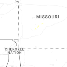
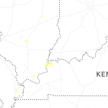
Kansas
| Local Time | Report Details |
|---|---|
| 1:51 PM CDT | Quarter sized hail reported near Jamestown, KS, 74.1 miles WNW of Manhattan, KS |
| 1:57 PM CDT | Hen Egg sized hail reported near Lincoln, KS, 65.3 miles E of Hays, KS |
| 1:58 PM CDT | Golf Ball sized hail reported near Lincoln, KS, 64.3 miles E of Hays, KS, near 14 hwy and jaguar rd. |
| 2:01 PM CDT | Quarter sized hail reported near Lincoln, KS, 66.9 miles E of Hays, KS, storm chaser also reported a low hanging wall cloud. |
| 3:40 PM CDT | Golf Ball sized hail reported near Offerle, KS, 68.8 miles S of Hays, KS, public social media report of golf ball sized hail on the northeast side of offerle. |
| 3:45 PM CDT | Quarter sized hail reported near Miltonvale, KS, 48.2 miles WNW of Manhattan, KS, report from mping: quarter (1.00 in.). |
| 3:49 PM CDT | Quarter sized hail reported near Kinsley, KS, 65.7 miles S of Hays, KS, social media report of quarter-size hail. |
| 3:50 PM CDT | Quarter sized hail reported near Miltonvale, KS, 49.1 miles WNW of Manhattan, KS |
| 3:50 PM CDT | Quarter sized hail reported near Miltonvale, KS, 47.4 miles WNW of Manhattan, KS, report from mping: quarter (1.00 in.). |
| 3:57 PM CDT | Golf Ball sized hail reported near Kinsley, KS, 65 miles S of Hays, KS, social media report of golf ball sized hail with photo. |
| 4:03 PM CDT | Quarter sized hail reported near Spearville, KS, 64 miles ESE of Garden City, KS, mping report of quarter sized hail. |
| 4:15 PM CDT | Half Dollar sized hail reported near Summerfield, KS, 57.8 miles N of Manhattan, KS |
| 4:23 PM CDT | Half Dollar sized hail reported near Kinsley, KS, 65.8 miles S of Hays, KS, social media report of half-dollar sized hail in kinsley with picture. |
| 4:28 PM CDT | Half Dollar sized hail reported near Clay Center, KS, 37.8 miles WNW of Manhattan, KS, report from mping: half dollar (1.25 in.). |
| 4:30 PM CDT | Quarter sized hail reported near Clay Center, KS, 37.6 miles NW of Manhattan, KS, report from mping: quarter (1.00 in.). |
| 4:32 PM CDT | Quarter sized hail reported near Bennington, KS, 52 miles W of Manhattan, KS |
| 4:37 PM CDT | Quarter sized hail reported near Spearville, KS, 69.6 miles E of Garden City, KS, social media report of quarter-sized hail. |
| 4:46 PM CDT | Quarter sized hail reported near Salina, KS, 61.1 miles WSW of Manhattan, KS, report from mping: quarter (1.00 in.). |
| 5:05 PM CDT | Half Dollar sized hail reported near Lewis, KS, 64.5 miles S of Hays, KS, social media report of half dollar sized hail. |
| 5:11 PM CDT | Quarter sized hail reported near Saint John, KS, 70.1 miles SSE of Hays, KS, reported nickel to quarter-size hail. |
| 5:38 PM CDT | Hen Egg sized hail reported near Haviland, KS, 81.7 miles S of Hays, KS, social media report with picture. |
| 5:55 PM CDT | Storm damage reported in reno county KS, 43.6 miles NW of Wichita, KS |
| 5:56 PM CDT | Public report estimated near 70 mph winds ahead of the main line of storm in reno county KS, 41.4 miles NW of Wichita, KS |
| 6:00 PM CDT | Facebook report of large branches down in north hutchinso in reno county KS, 42.8 miles NW of Wichita, KS |
| 6:00 PM CDT | Quarter sized hail reported near Haviland, KS, 78 miles S of Hays, KS, social media report of quarter-size hail. |
| 6:10 PM CDT | Quarter sized hail reported near Chapman, KS, 28.5 miles WSW of Manhattan, KS, report from mping: quarter (1.00 in.). |
| 6:10 PM CDT | Delayed report... location and time estimated from radar. an 80 year old barn was completely destroyed near abbyville... with some other damage to various outbuilding in reno county KS, 51.2 miles WNW of Wichita, KS |
| 6:15 PM CDT | Quarter sized hail reported near Hutchinson, KS, 41.9 miles NW of Wichita, KS |
| 6:17 PM CDT | Quarter sized hail reported near Hutchinson, KS, 41.5 miles NW of Wichita, KS, report from mping: quarter (1.00 in.). |
| 6:17 PM CDT | Storm damage reported in reno county KS, 34.8 miles WNW of Wichita, KS |
| 6:17 PM CDT | Storm damage reported in mcpherson county KS, 37.6 miles NNW of Wichita, KS |
| 6:20 PM CDT | Quarter sized hail reported near Inman, KS, 44.3 miles NNW of Wichita, KS |
| 6:20 PM CDT | Half Dollar sized hail reported near Hutchinson, KS, 43.2 miles NW of Wichita, KS, twitter report. |
| 6:22 PM CDT | Storm damage reported in riley county KS, 9.3 miles WSW of Manhattan, KS |
| 6:23 PM CDT | Picture of a 6 foot diameter tree limb across leavenworth street. time estimated from rada in riley county KS, 0.4 miles W of Manhattan, KS |
| 6:28 PM CDT | Storm damage reported in riley county KS, 3.6 miles N of Manhattan, KS |
| 6:29 PM CDT | Ping Pong Ball sized hail reported near Inman, KS, 44.1 miles NW of Wichita, KS |
| 6:30 PM CDT | Ping Pong Ball sized hail reported near Hutchinson, KS, 42.7 miles NW of Wichita, KS |
| 6:32 PM CDT | Hen Egg sized hail reported near Inman, KS, 39.2 miles NNW of Wichita, KS |
| 6:41 PM CDT | Personal weather statio in pottawatomie county KS, 6.7 miles NNE of Manhattan, KS |
| 6:42 PM CDT | Quarter sized hail reported near Manhattan, KS, 4.4 miles WSW of Manhattan, KS, report from mping: quarter (1.00 in.). |
| 6:47 PM CDT | Quarter sized hail reported near Arlington, KS, 48.5 miles WNW of Wichita, KS |
| 6:49 PM CDT | Measured on a personal weather statio in pottawatomie county KS, 12.4 miles ENE of Manhattan, KS |
| 7:00 PM CDT | 911 report of power lines dow in harvey county KS, 23.7 miles N of Wichita, KS |
| 7:01 PM CDT | Damage to hay barn. time estimated from rada in nemaha county KS, 41.2 miles NE of Manhattan, KS |
| 7:12 PM CDT | Grain bin... hog barn... large limbs damaged. time estimated from rada in nemaha county KS, 52.3 miles NE of Manhattan, KS |
| 7:15 PM CDT | Barn destroye in jackson county KS, 45 miles ENE of Manhattan, KS |
| 7:17 PM CDT | Power line down; time estimated from rada in harvey county KS, 24.3 miles N of Wichita, KS |
| 7:19 PM CDT | Reports of tree and shingles damag in jackson county KS, 45.2 miles ENE of Manhattan, KS |
| 7:26 PM CDT | Measured on a personal weather statio in jackson county KS, 46.1 miles ENE of Manhattan, KS |
| 7:30 PM CDT | Quarter sized hail reported near Haven, KS, 28.4 miles WNW of Wichita, KS, facebook report. |
| 7:34 PM CDT | Ping Pong Ball sized hail reported near Alma, KS, 12.5 miles SSE of Manhattan, KS |
| 7:37 PM CDT | Quarter sized hail reported near Halstead, KS, 22.3 miles NNW of Wichita, KS |
| 7:39 PM CDT | Several reports of downed wires and power outages north and northwest of muscotah. time estimated from rada in atchison county KS, 60.5 miles ENE of Manhattan, KS |
| 7:41 PM CDT | Delayed report. 12 to 16 inch diameter tree trunk snapped. several tree limbs down. time estimated from rada in harvey county KS, 26.4 miles N of Wichita, KS |
| 7:41 PM CDT | Storm damage reported in harvey county KS, 25.8 miles N of Wichita, KS |
| 7:51 PM CDT | Storm damage reported in morris county KS, 35.4 miles S of Manhattan, KS |
| 7:53 PM CDT | Kewk asos repor in harvey county KS, 25.2 miles N of Wichita, KS |
| 7:56 PM CDT | Asos station kp28 medicine lodg in barber county KS, 72.4 miles WSW of Wichita, KS |
| 8:02 PM CDT | Tree down across route 7 north of atchison. time estimated from rada in doniphan county KS, 51.4 miles NW of Kansas City, MO |
| 8:05 PM CDT | Storm damage reported in wabaunsee county KS, 34.4 miles ESE of Manhattan, KS |
| 8:17 PM CDT | Personal weather statio in shawnee county KS, 44.5 miles ESE of Manhattan, KS |
| 8:18 PM CDT | Storm damage reported in shawnee county KS, 42.4 miles ESE of Manhattan, KS |
| 8:20 PM CDT | Kfoe aso in shawnee county KS, 50.5 miles ESE of Manhattan, KS |
| 8:21 PM CDT | Storm damage reported in shawnee county KS, 48.7 miles E of Manhattan, KS |
| 8:26 PM CDT | Quarter sized hail reported near Kingman, KS, 43.6 miles W of Wichita, KS, lots of hail... up to quarter size hail. |
| 8:30 PM CDT | Quarter sized hail reported near Kingman, KS, 42.9 miles W of Wichita, KS, spotter driving through storm... lots of hail up to quarter size. |
| 8:32 PM CDT | Kfoe aso in shawnee county KS, 50.5 miles ESE of Manhattan, KS |
| 8:34 PM CDT | 50-60 mph driving down hwy 7 in osage county KS, 53.5 miles ESE of Manhattan, KS |
| 8:34 PM CDT | Storm damage reported in jefferson county KS, 52 miles W of Kansas City, MO |
| 8:34 PM CDT | Personal weather statio in shawnee county KS, 51.2 miles W of Kansas City, MO |
| 8:46 PM CDT | Time estimated from rada in douglas county KS, 39.6 miles WSW of Kansas City, MO |
| 8:48 PM CDT | Personal weather statio in douglas county KS, 39.8 miles WSW of Kansas City, MO |
| 8:49 PM CDT | Delayed report. wooden play set broken and rolled 10 yards. time estimated from rada in douglas county KS, 38.8 miles WSW of Kansas City, MO |
| 8:50 PM CDT | Delayed report. branches down... largest one 8 inches in diameter. time estimated from rada in douglas county KS, 36.9 miles WSW of Kansas City, MO |
| 8:52 PM CDT | Power line fallen on trees. time estimated from radar. report relayed via social medi in atchison county KS, 43.2 miles NW of Kansas City, MO |
| 8:54 PM CDT | Prviate weather senso in leavenworth county KS, 24.9 miles WNW of Kansas City, MO |
| 8:55 PM CDT | Em relayed 92 wind in leavenworth county KS, 23.9 miles WNW of Kansas City, MO |
| 9:02 PM CDT | Corrects previous tstm wnd gst report from 2 ene jarbalo. pws measured 61 mph gust in leavenworth county KS, 25.1 miles WNW of Kansas City, MO |
| 9:02 PM CDT | Corrects previous tstm wnd gst report from 2 ene jarbalo. pws measured 61 mph gust in leavenworth county KS, 25.1 miles WNW of Kansas City, MO |
| 9:05 PM CDT | Em relayed 60 mph wind gus in leavenworth county KS, 19.9 miles W of Kansas City, MO |
| 9:06 PM CDT | Downed wires near 167th street. time estimated from rada in leavenworth county KS, 27.4 miles NW of Kansas City, MO |
| 9:09 PM CDT | Em relayed 72 mph wind gust in johnson county KS, 33.1 miles SW of Kansas City, MO |
| 9:09 PM CDT | Pws measured 70 mph wind gus in johnson county KS, 16 miles WSW of Kansas City, MO |
| 9:11 PM CDT | Em relayed spotter measured 77 mph wind gus in johnson county KS, 27.6 miles SW of Kansas City, MO |
| 9:13 PM CDT | Em relayed spotter report of 84 mph wind gus in johnson county KS, 27.6 miles SW of Kansas City, MO |
| 9:14 PM CDT | Downed tree at a residence in kansas city... ks. time estimated from rada in wyandotte county KS, 13.4 miles W of Kansas City, MO |
| 9:15 PM CDT | Storm damage reported in sedgwick county KS, 9.8 miles NW of Wichita, KS |
| 9:15 PM CDT | Pws measured 63 mph wind gus in johnson county KS, 14 miles SW of Kansas City, MO |
| 9:15 PM CDT | 60-70 mph; time estimated from rada in sedgwick county KS, 18.9 miles W of Wichita, KS |
| 9:17 PM CDT | Storm damage reported in sedgwick county KS, 7.8 miles N of Wichita, KS |
| 9:17 PM CDT | Large tree down on a house near 46th and gibbs. time confirmed from rada in wyandotte county KS, 5.5 miles WSW of Kansas City, MO |
| 9:25 PM CDT | Storm damage reported in sedgwick county KS, 5.8 miles ESE of Wichita, KS |
| 9:26 PM CDT | Em relayed spotter report of 70 mph wind in johnson county KS, 15.7 miles WSW of Kansas City, MO |
| 9:41 PM CDT | Storm damage reported in sedgwick county KS, 7.7 miles NE of Wichita, KS |
| 9:45 PM CDT | Storm damage reported in kingman county KS, 31.6 miles WSW of Wichita, KS |
| 9:46 PM CDT | Multiple reports of downed wires and power outages north of louisburg. time estimated from rada in miami county KS, 31.9 miles SSW of Kansas City, MO |
| 9:59 PM CDT | Storm damage reported in sumner county KS, 26.4 miles SW of Wichita, KS |
| 10:10 PM CDT | Downed wires near 367th street. time estimated from rada in miami county KS, 47.6 miles SSW of Kansas City, MO |
| 10:20 PM CDT | Personal weather station. delayed repor in coffey county KS, 38.7 miles NNW of Chanute, KS |
| 10:26 PM CDT | Quarter sized hail reported near Conway Springs, KS, 26.4 miles SW of Wichita, KS, dimes with some quarters. |
| 10:26 PM CDT | Downed wires near 383rd street. time estimated from rada in miami county KS, 46.5 miles S of Kansas City, MO |
| 10:37 PM CDT | Golf Ball sized hail reported near Argonia, KS, 30.3 miles SSW of Wichita, KS, report from mping: golf ball (1.75 in.). |
| 10:57 PM CDT | Ping Pong Ball sized hail reported near Wellington, KS, 30.1 miles SSW of Wichita, KS, report from mping: ping pong ball (1.50 in.). |
| 11:02 PM CDT | Quarter sized hail reported near Wellington, KS, 29 miles S of Wichita, KS |
| 11:05 PM CDT | Mping report. tree (unknown diameter) uproote in coffey county KS, 39 miles NNW of Chanute, KS |
| 11:06 PM CDT | Quarter sized hail reported near Wellington, KS, 28.1 miles S of Wichita, KS, report from mping: quarter (1.00 in.). |
| 12:12 AM CDT | Kwld measured 67 mp in cowley county KS, 39.2 miles SSE of Wichita, KS |
| 12:12 AM CDT | Corrects previous tstm wnd gst report from 4 sw winfield. estimated 60-70 mph and dime size hai in cowley county KS, 36.6 miles SSE of Wichita, KS |
| 12:12 AM CDT | Estimated 60-70 mph and dime size hai in cowley county KS, 36 miles SSE of Wichita, KS |
| 12:33 AM CDT | Multiple reports of tree limbs down and power outage in cowley county KS, 36.2 miles SSE of Wichita, KS |
| 12:35 AM CDT | Quarter sized hail reported near Arkansas City, KS, 45.6 miles SSE of Wichita, KS, reports of nickel to quarter size hail and 52 mph wind. |
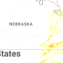
Nebraska
| Local Time | Report Details |
|---|---|
| 3:20 PM CDT | Quarter sized hail reported near Beatrice, NE, 75.9 miles N of Manhattan, KS |
| 3:22 PM CDT | Personal weather station gusted to 70 mp in gage county NE, 62.7 miles N of Manhattan, KS |
| 3:27 PM CDT | Golf Ball sized hail reported near Pickrell, NE, 72.7 miles SW of Omaha, NE, spotter report driving on hwy 77 south toward beatrice. |
| 3:27 PM CDT | Corrects previous non-tstm wnd gst report from 2 n blue springs. personal weather statio in gage county NE, 68.6 miles N of Manhattan, KS |
| 3:47 PM CDT | Caller reported an 81 mph wind gust measured from a personal weather station. also reported 6 to 8 inch diameter tree limbs broke in pawnee county NE, 72.7 miles N of Manhattan, KS |
| 3:49 PM CDT | Golf Ball sized hail reported near Clarkson, NE, 72.1 miles WNW of Omaha, NE |
| 3:56 PM CDT | Personal weather statio in johnson county NE, 66.5 miles SSW of Omaha, NE |
| 4:01 PM CDT | Lots of large tree limbs down. time is estimate in johnson county NE, 62.8 miles SSW of Omaha, NE |
| 4:08 PM CDT | Downed trees... damage to grain bins... and damaged farm outbuildings. possible tornado damage. time estimated from rada in johnson county NE, 62.7 miles S of Omaha, NE |
| 4:11 PM CDT | Quarter sized hail reported near Burchard, NE, 72 miles N of Manhattan, KS, report from mping: quarter (1.00 in.). |
| 4:12 PM CDT | Corrects previous tstm wnd gst report from 5 ssw johnson. personal weather statio in nemaha county NE, 63.1 miles S of Omaha, NE |
| 4:12 PM CDT | Corrects previous tstm wnd gst report from 5 ssw johnson. personal weather statio in nemaha county NE, 63.1 miles S of Omaha, NE |
| 4:26 PM CDT | Ping Pong Ball sized hail reported near Davenport, NE, 54.5 miles SSE of Grand Island, NE, hail the size of quarters to ping pong balls... most were smaller. |
| 4:27 PM CDT | Reports of extensive damage in auburn. possible people trapped in homes. possible tornado damage. time is estimate in nemaha county NE, 60.3 miles S of Omaha, NE |
| 4:34 PM CDT | Personal weather station gusted to 62 mp in nemaha county NE, 58.9 miles S of Omaha, NE |
| 4:40 PM CDT | Quarter sized hail reported near Strang, NE, 53 miles SE of Grand Island, NE |
| 4:43 PM CDT | Golf Ball sized hail reported near Brock, NE, 52.7 miles S of Omaha, NE, public report of golf ball size hail north of auburn. location and time are estimated from radar. |
| 4:45 PM CDT | Personal weather statio in nemaha county NE, 57.3 miles SSE of Omaha, NE |
| 4:52 PM CDT | Golf Ball sized hail reported near Milligan, NE, 57.8 miles ESE of Grand Island, NE |
| 5:04 PM CDT | Golf Ball sized hail reported near Friend, NE, 61.6 miles ESE of Grand Island, NE, trained spotter reported golf ball sized hail 7.5 miles south of friend. |
| 5:08 PM CDT | Ping Pong Ball sized hail reported near Humboldt, NE, 74 miles S of Omaha, NE, report from mping: ping pong ball (1.50 in.). |
| 5:30 PM CDT | Golf Ball sized hail reported near Pilger, NE, 77.3 miles NW of Omaha, NE, dime to golf ball size hail. |
| 5:39 PM CDT | Quarter sized hail reported near Friend, NE, 58.6 miles ESE of Grand Island, NE, mix of peas and quarters. |
| 5:46 PM CDT | Quarter sized hail reported near Milford, NE, 63.3 miles E of Grand Island, NE, report relayed by nws employee via nwschat. |
| 5:50 PM CDT | Quarter sized hail reported near Wayne, NE, 85.9 miles E of Oneill, NE |
| 5:52 PM CDT | Quarter sized hail reported near Wayne, NE, 86.2 miles NW of Omaha, NE, report from mping: quarter (1.00 in.). |
| 6:02 PM CDT | Ping Pong Ball sized hail reported near Allen, NE, 78.6 miles S of Sioux Falls, SD |
| 6:10 PM CDT | Quarter sized hail reported near Ponca, NE, 70.1 miles S of Sioux Falls, SD, some quarter sized hail stones... but mostly dime sized. heavy rain... no wind... and no damage. |
| 6:12 PM CDT | Half Dollar sized hail reported near Fairbury, NE, 76.8 miles NNW of Manhattan, KS, trained spotter reported half dollar size hail. |
| 6:15 PM CDT | Ping Pong Ball sized hail reported near Ponca, NE, 66.6 miles S of Sioux Falls, SD, rainfall so far this evening has only been 0.25 inch... but the sky looked like heavier and hail fell to the southeast closer to ponca. |
| 6:19 PM CDT | Half Dollar sized hail reported near Fairbury, NE, 74.9 miles NNW of Manhattan, KS, public report of half dollar size hail. |
| 6:21 PM CDT | Quarter sized hail reported near Valparaiso, NE, 48 miles W of Omaha, NE |
| 6:30 PM CDT | Ping Pong Ball sized hail reported near Fairbury, NE, 73.8 miles NNW of Manhattan, KS, report from mping: ping pong ball (1.50 in.). |
| 6:40 PM CDT | Quarter sized hail reported near Diller, NE, 73.1 miles NNW of Manhattan, KS, mix of dimes with a few quarters. |
| 7:15 PM CDT | Quarter sized hail reported near Elkhorn, NE, 14 miles W of Omaha, NE, report from mping: quarter (1.00 in.). |
West Virginia
| Local Time | Report Details |
|---|---|
| 4:31 PM EDT | Quarter sized hail reported near Baker, WV, 59.5 miles E of Elkins, WV, public reports quarter size hail in baker... wv. time estimated from radar. |
| 6:11 PM EDT | County 911 reports downed tree near intersection of shireoaks drive and lost roa in berkeley county WV, 75.6 miles W of Baltimore, MD |
| 6:21 PM EDT | County 911 reports a couple of trees down on 130th block of energy drive... and 440th block of trimble ave. time estimated from rada in berkeley county WV, 72.9 miles W of Baltimore, MD |
| 11:08 PM EDT | Tree down near the intersection of appalachian highway and northridge road. time estimated from rada in tucker county WV, 24.3 miles ENE of Elkins, WV |
Ohio
| Local Time | Report Details |
|---|---|
| 4:42 PM EDT | Power lines down near reed road and south berkey southern roa in lucas county OH, 73.7 miles ENE of Fort Wayne, IN |
| 4:45 PM EDT | Power lines blown down near south centennial road and cr 30 in the holland area. report from social medi in lucas county OH, 80.7 miles ENE of Fort Wayne, IN |
| 5:04 PM EDT | Tree limb on transformer. time estimated via rada in wood county OH, 77 miles ENE of Fort Wayne, IN |
Virginia
| Local Time | Report Details |
|---|---|
| 5:10 PM EDT | Quarter sized hail reported near Winchester, VA, 79.4 miles ENE of Elkins, WV, mping report of 1 inch hail |
| 5:20 PM EDT | Tree down on fishel road near back mountain roa in frederick county VA, 82 miles ENE of Elkins, WV |
| 5:20 PM EDT | County 911 reports tree down onto the roadway at the 400th block of fishel ave. time estimated from rada in frederick county VA, 82.6 miles ENE of Elkins, WV |
| 5:48 PM EDT | City of winchester em reported trees and wires down at intersection of brick kiln rd and smithfield ave. time estimated from rada in frederick county VA, 82.9 miles W of Baltimore, MD |
| 9:31 PM EDT | Tree fell on traile in buchanan county VA, 43.9 miles N of Bristol, TN |
Maryland
| Local Time | Report Details |
|---|---|
| 5:16 PM EDT | Multiple trees down on high germany road and bottenfield roa in washington county MD, 79 miles SSW of State College, PA |
Iowa
| Local Time | Report Details |
|---|---|
| 5:00 PM CDT | Quarter sized hail reported near Hawarden, IA, 45.1 miles SSE of Sioux Falls, SD |
| 5:04 PM CDT | Ping Pong Ball sized hail reported near Farragut, IA, 47.7 miles SSE of Omaha, NE, ping pong ball size hail reported south of farragut. |
| 5:23 PM CDT | Golf Ball sized hail reported near Correctionville, IA, 35.1 miles WSW of Storm Lake, IA, social media picture. |
| 5:26 PM CDT | Ping Pong Ball sized hail reported near Correctionville, IA, 31.7 miles WSW of Storm Lake, IA, picture via social media. |
| 5:35 PM CDT | Quarter sized hail reported near Washta, IA, 26.8 miles W of Storm Lake, IA, picture via social media. |
| 5:36 PM CDT | Ping Pong Ball sized hail reported near College Springs, IA, 61.6 miles SE of Omaha, NE, time is estimated. |
| 5:47 PM CDT | Personal weather statio in page county IA, 63 miles SE of Omaha, NE |
| 5:51 PM CDT | Quarter sized hail reported near Clarinda, IA, 59.2 miles SE of Omaha, NE |
| 5:51 PM CDT | Quarter sized hail reported near Sanborn, IA, 44.1 miles NNW of Storm Lake, IA, report from mping: quarter (1.00 in.). also had picture via social media. |
| 5:57 PM CDT | Quarter sized hail reported near Clarinda, IA, 60.1 miles SE of Omaha, NE, report from mping: quarter (1.00 in.). |
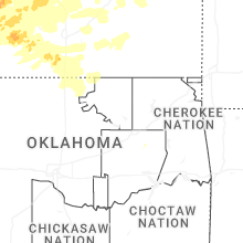
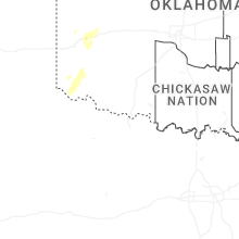
Oklahoma
| Local Time | Report Details |
|---|---|
| 5:25 PM CDT | Half Dollar sized hail reported near Mangum, OK, 51.1 miles NE of Childress, TX |
| 5:59 PM CDT | Quarter sized hail reported near Elk City, OK, 71.3 miles S of Woodward, OK |
| 6:01 PM CDT | Half Dollar sized hail reported near Elk City, OK, 70.6 miles S of Woodward, OK |
| 6:30 PM CDT | Putnam mesone in dewey county OK, 43.9 miles SSE of Woodward, OK |
| 12:45 AM CDT | Power lines down at peckham road and w street. time estimated from rada in kay county OK, 56.9 miles SSE of Wichita, KS |
| 1:00 AM CDT | Power lines and trees blown down. time estimated by rada in kay county OK, 58.1 miles SSE of Wichita, KS |
| 1:01 AM CDT | Half Dollar sized hail reported near Ponca City, OK, 69.6 miles SSE of Wichita, KS, report from mping: half dollar (1.25 in.). |
| 1:05 AM CDT | Storm damage reported in kay county OK, 60.4 miles SSE of Wichita, KS |
Pennsylvania
| Local Time | Report Details |
|---|---|
| 8:24 PM EDT | Tree fell down onto garage and car... possibly also impacting the roof of a residence. no injuries reporte in centre county PA, 3.1 miles W of State College, PA |
| 8:49 PM EDT | Tree down on wires in the 500 block of high stree in clinton county PA, 30.9 miles NE of State College, PA |
Connect with Interactive Hail Maps