

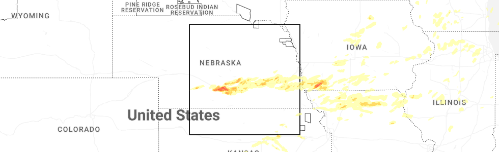
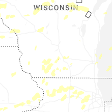
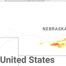
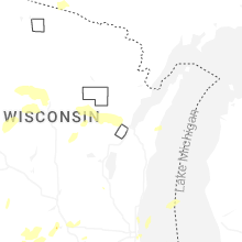
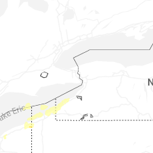
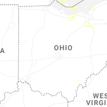
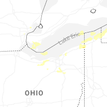
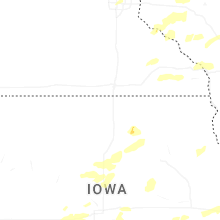
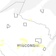
Hail Map for Wednesday, June 10, 2026
Number of Impacted Households on 6/10/2026
0
Impacted by 1" or Larger Hail
0
Impacted by 1.75" or Larger Hail
0
Impacted by 2.5" or Larger Hail
Square Miles of Populated Area Impacted on 6/10/2026
0
Impacted by 1" or Larger Hail
0
Impacted by 1.75" or Larger Hail
0
Impacted by 2.5" or Larger Hail
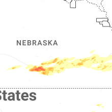
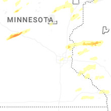


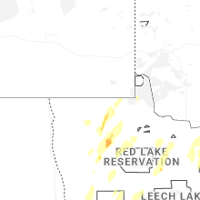
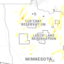
Cities Most Affected by Hail Storms of 6/10/2026
| Hail Size | Demographics of Zip Codes Affected | ||||||
|---|---|---|---|---|---|---|---|
| City | Count | Average | Largest | Pop Density | House Value | Income | Age |
| Wadena, MN | 4 | 1.94 | 2.00 | 50 | $56k | $30.8k | 41.5 |
| Sterling, KS | 3 | 2.08 | 2.50 | 12 | $60k | $35.9k | 33.3 |
| Glenwood, MN | 2 | 1.88 | 2.00 | 29 | $79k | $35.4k | 47.0 |
| Elm Creek, NE | 2 | 1.75 | 1.75 | 6 | $76k | $36.9k | 38.1 |
| Buhler, KS | 2 | 1.75 | 1.75 | 19 | $68k | $44.0k | 43.3 |
| Little River, KS | 1 | 2.75 | 2.75 | 5 | $39k | $33.6k | 39.3 |
| Clarinda, IA | 1 | 2.50 | 2.50 | 28 | $69k | $37.2k | 41.6 |
| Villard, MN | 1 | 2.50 | 2.50 | 12 | $71k | $34.7k | 41.1 |
| Raymond, NE | 1 | 2.50 | 2.50 | 24 | $115k | $58.3k | 43.1 |
| Great Bend, KS | 1 | 2.00 | 2.00 | 78 | $61k | $33.4k | 38.0 |
| Malcolm, NE | 1 | 2.00 | 2.00 | 31 | $103k | $52.0k | 42.2 |
| Weldon, IA | 1 | 2.00 | 2.00 | 6 | $27k | $28.6k | 47.1 |
| Paris, MO | 1 | 1.75 | 1.75 | 14 | $49k | $31.5k | 47.0 |
| Pattonsburg, MO | 1 | 1.75 | 1.75 | 7 | $57k | $31.5k | 41.7 |
| Ellinwood, KS | 1 | 1.75 | 1.75 | 15 | $47k | $30.8k | 44.3 |
| Minden, NE | 1 | 1.75 | 1.75 | 12 | $77k | $40.3k | 44.2 |
| Chase, KS | 1 | 1.75 | 1.75 | 4 | $26k | $34.0k | 39.6 |
| Axtell, NE | 1 | 1.75 | 1.75 | 10 | $96k | $39.3k | 38.6 |
| Burrton, KS | 1 | 1.75 | 1.75 | 8 | $58k | $37.6k | 40.8 |
| Enterprise, KS | 1 | 1.75 | 1.75 | 14 | $51k | $35.2k | 37.0 |
| Lyons, KS | 1 | 1.75 | 1.75 | 23 | $46k | $35.8k | 40.0 |
| Sebeka, MN | 1 | 1.75 | 1.75 | 10 | $47k | $31.7k | 42.3 |
| Hutchinson, KS | 1 | 1.75 | 1.75 | 297 | $94k | $45.1k | 46.4 |
| Junction City, KS | 1 | 1.75 | 1.75 | 128 | $67k | $31.2k | 29.3 |
| Barnard, MO | 1 | 1.75 | 1.75 | 8 | $35k | $35.2k | 42.3 |
| Chisago City, MN | 1 | 1.75 | 1.75 | 211 | $142k | $50.3k | 42.3 |
| Hastings, NE | 1 | 1.75 | 1.75 | 184 | $78k | $36.9k | 37.0 |
| Princeton, MO | 1 | 1.75 | 1.75 | 10 | $35k | $31.0k | 41.9 |
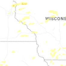
Hail and Wind Damage Spotted on 6/10/2026
Filter by Report Type:Hail ReportsWind Reports
States Impacted
Wisconsin, Missouri, Iowa, Illinois, Minnesota, Virginia, New York, Pennsylvania, Indiana, Texas, Michigan, North Dakota, North Carolina, Ohio, Kansas, NebraskaWisconsin
| Local Time | Report Details |
|---|---|
| 7:04 AM CDT | Oak tree snappe in taylor county WI, 61.3 miles SW of Rhinelander, WI |
| 7:06 AM CDT | Tree down along highway 9 in marathon county WI, 52.9 miles SW of Rhinelander, WI |
| 12:20 PM CDT | Delayed report relayed via state official. report of one farm with roof/overhead door damage and two residences with roof damage and blown over trees in pierce count in pierce county WI, 56.1 miles ESE of Minneapolis, MN |
| 12:35 PM CDT | A couple large trees downed east of plum cit in pepin county WI, 61.2 miles ESE of Minneapolis, MN |
| 12:47 PM CDT | Several reports of trees and powerlines down between downsville and menomoni in dunn county WI, 67 miles ESE of Minneapolis, MN |
| 12:49 PM CDT | Storm damage reported in grant county WI, 69 miles NE of Cedar Rapids, IA |
| 12:50 PM CDT | Delayed report. downed trees caused some roof damage to hous in grant county WI, 69 miles NE of Cedar Rapids, IA |
| 12:56 PM CDT | Tree down on a powerline in menomonie. relayed from dispatc in dunn county WI, 65.9 miles E of Minneapolis, MN |
| 12:56 PM CDT | Image of large tree uprooted via social media. time estimated from rada in grant county WI, 68.3 miles WSW of Madison, WI |
| 1:10 PM CDT | Storm damage reported in grant county WI, 69.7 miles NE of Cedar Rapids, IA |
| 1:15 PM CDT | Delayed report relayed by law enforcement. large tree branch down on the side of a hous in dunn county WI, 76.2 miles NNW of La Crosse, WI |
| 1:17 PM CDT | Storm damage reported in grant county WI, 59.6 miles WSW of Madison, WI |
| 1:19 PM CDT | Also reported some trees down and signs blown aroun in grant county WI, 69.2 miles WSW of Madison, WI |
| 1:21 PM CDT | Storm damage reported in grant county WI, 59.6 miles WSW of Madison, WI |
| 1:25 PM CDT | Tree down on a structure. time est from rada in iowa county WI, 43.3 miles WSW of Madison, WI |
| 1:26 PM CDT | Corrects time of previous tstm wnd dmg report from 3 sw hollandale. metal pole barn destroyed with debris scattered to the n/ne. picture from social media. time est fro in iowa county WI, 33.8 miles WSW of Madison, WI |
| 1:27 PM CDT | Storm damage reported in grant county WI, 63.3 miles W of Madison, WI |
| 1:28 PM CDT | Trained spotter measures 88 mph gust on home weather statio in lafayette county WI, 44.8 miles SW of Madison, WI |
| 1:31 PM CDT | Storm damage reported in grant county WI, 54.2 miles WSW of Madison, WI |
| 1:35 PM CDT | Report of a couple trees down in the town of seymou in eau claire county WI, 69.9 miles N of La Crosse, WI |
| 1:35 PM CDT | Storm damage reported in grant county WI, 57.2 miles WSW of Madison, WI |
| 1:40 PM CDT | Report of large tree branch down on home... time estimated from rada in green county WI, 24.6 miles SSW of Madison, WI |
| 1:40 PM CDT | Brigham wisconet statio in iowa county WI, 24 miles WSW of Madison, WI |
| 1:44 PM CDT | Delayed report... time estimated from radar. tree down near fall cree in eau claire county WI, 65.4 miles N of La Crosse, WI |
| 1:46 PM CDT | Roof off of an apartment buildin in iowa county WI, 38.9 miles WSW of Madison, WI |
| 1:47 PM CDT | Many large branches down across town. pictures from social media. time est from rada in dane county WI, 19 miles WNW of Madison, WI |
| 1:52 PM CDT | 70mph wind gust measured with handheld anemometer - kestrel 250 in dane county WI, 9.7 miles SW of Madison, WI |
| 1:55 PM CDT | Picture of a large branch split off mature tre in dane county WI, 2.9 miles WNW of Madison, WI |
| 2:00 PM CDT | Home wx statio in sauk county WI, 35 miles WNW of Madison, WI |
| 2:00 PM CDT | Large tree uprooted and on power lines. picture from social media. time est from rada in dane county WI, 0.6 miles NE of Madison, WI |
| 2:00 PM CDT | Delayed report... time estimated from radar. tree down on hwy g north of august in eau claire county WI, 62.4 miles N of La Crosse, WI |
| 2:05 PM CDT | Approx 6 inch tree branch dow in dane county WI, 9.8 miles NNE of Madison, WI |
| 2:08 PM CDT | Many large branches down. pictures from social medi in columbia county WI, 23 miles N of Madison, WI |
| 2:10 PM CDT | Trained spotter estimates 80 mph wind gust in rock county WI, 20.9 miles SE of Madison, WI |
| 2:10 PM CDT | Home wx statio in dane county WI, 12.7 miles NE of Madison, WI |
| 2:10 PM CDT | Home wx statio in columbia county WI, 16.5 miles N of Madison, WI |
| 2:12 PM CDT | 85 mph wind gust estimated from home instrumentatio in rock county WI, 38.7 miles SSE of Madison, WI |
| 2:15 PM CDT | Large branch down. picture from social media. time est from rada in rock county WI, 23.2 miles SE of Madison, WI |
| 2:17 PM CDT | Large branches down. picture from social media. time est from rada in dane county WI, 18.3 miles ENE of Madison, WI |
| 2:22 PM CDT | Large branch down. picture from social media. time est from rada in rock county WI, 29.6 miles SE of Madison, WI |
| 2:23 PM CDT | Tree blocking roadway. time of report 448 pm cdt. time trees fell estimated from rada in adams county WI, 47.8 miles NNW of Madison, WI |
| 2:26 PM CDT | Trained spotter estimates 85 mph wind gust in jefferson county WI, 23.8 miles ESE of Madison, WI |
| 2:27 PM CDT | Tree limbs dow in clark county WI, 73 miles NNE of La Crosse, WI |
| 2:30 PM CDT | 2 foot diameter pine tree trunk snapped. picture from social media. time est from rada in marquette county WI, 39.5 miles N of Madison, WI |
| 2:30 PM CDT | Report of a 8-10 inch downed tree. time estimated from rada in juneau county WI, 56.7 miles E of La Crosse, WI |
| 2:34 PM CDT | Home wx statio in jefferson county WI, 32.4 miles ENE of Madison, WI |
| 2:35 PM CDT | Tree fell on power pole/light pol in dodge county WI, 31.8 miles ENE of Madison, WI |
| 2:35 PM CDT | Trained spotter estimates 80 mph wind gust in rock county WI, 27.9 miles SE of Madison, WI |
| 2:39 PM CDT | Trained spotter estimates 75 mph wind gust in jefferson county WI, 30.6 miles ESE of Madison, WI |
| 2:40 PM CDT | Iconic blue barn destroyed. multiple social media pictures. time est from rada in dodge county WI, 35.5 miles NE of Madison, WI |
| 2:41 PM CDT | Report of a tree that fell on a house in mauston... estimated 2.5ft in diameter. time estimated from rada in juneau county WI, 59.1 miles E of La Crosse, WI |
| 2:45 PM CDT | Home wx statio in dodge county WI, 40.7 miles NE of Madison, WI |
| 2:49 PM CDT | Home wx statio in green lake county WI, 55.4 miles NNE of Madison, WI |
| 2:50 PM CDT | Large tree trunk snapped. picture from social media. time estimated from rada in green lake county WI, 48.3 miles NNE of Madison, WI |
| 2:50 PM CDT | Tree downed. time of report is 355 pm cdt. time tree fell estimated from rada in adams county WI, 63.5 miles NNW of Madison, WI |
| 3:00 PM CDT | Large tree down near intersection of main st and union st north of downtown. picture from social media. time est from rada in washington county WI, 53.6 miles ENE of Madison, WI |
| 3:00 PM CDT | Tree on house. time est from rada in fond du lac county WI, 59.1 miles NNE of Madison, WI |
| 3:00 PM CDT | Large branches down. picture from social media. time est from rada in green lake county WI, 59.6 miles NNE of Madison, WI |
| 3:00 PM CDT | Large branch down from oak tree and minor shingle damage from a newer roo in marquette county WI, 56.6 miles N of Madison, WI |
| 3:00 PM CDT | Several structures damaged across dodge count in dodge county WI, 50.7 miles NE of Madison, WI |
| 3:00 PM CDT | Damage to structures in downtown horico in dodge county WI, 46.2 miles NE of Madison, WI |
| 3:09 PM CDT | Several large branches dow in winnebago county WI, 49.5 miles SW of Green Bay, WI |
| 3:10 PM CDT | Several trees down in fond du lac and brando in fond du lac county WI, 55.4 miles SSW of Green Bay, WI |
| 3:10 PM CDT | Image of large tree uprooted via social medi in adams county WI, 69.6 miles ENE of La Crosse, WI |
| 3:14 PM CDT | Small tree snapped about half way up. picture from social medi in waukesha county WI, 63.4 miles E of Madison, WI |
| 3:17 PM CDT | Asos station kosh oshkosh airpor in winnebago county WI, 46.1 miles SW of Green Bay, WI |
| 3:20 PM CDT | Numerous trees and power lines down in the cit in winnebago county WI, 43.6 miles SW of Green Bay, WI |
| 3:30 PM CDT | Large tree down. branches fell on house. unknown house damag in winnebago county WI, 31.7 miles SW of Green Bay, WI |
| 3:40 PM CDT | Trees and power lines down at 10/11 in calumet county WI, 26.5 miles SW of Green Bay, WI |
| 3:40 PM CDT | Many reports of downed trees and power lines with focus in northern half of the county. time est from rada in sheboygan county WI, 47.3 miles S of Green Bay, WI |
| 3:40 PM CDT | Multiple trees and power lines are dow in outagamie county WI, 26.4 miles SW of Green Bay, WI |
| 3:41 PM CDT | Kenosha airpor in kenosha county WI, 51.7 miles NNW of Chicago, IL |
| 3:50 PM CDT | Large trees down at john muir middle school. time estimated from rada in marathon county WI, 48.3 miles SSW of Rhinelander, WI |
| 4:04 PM CDT | Trees dow in portage county WI, 67.7 miles W of Green Bay, WI |
| 4:33 PM CDT | In bowler trees and power line dow in shawano county WI, 35.2 miles WNW of Green Bay, WI |
| 4:50 PM CDT | Trees across the roads between neopit and langlade county line. time estimated by rada in menominee county WI, 52.1 miles SSE of Rhinelander, WI |
| 5:29 PM CDT | Metal pole barn destroyed with debris scattered to the n/ne. picture from social media. time est from rada in iowa county WI, 33.8 miles WSW of Madison, WI |
| 5:40 PM CDT | Pole barn damaged and a couple trees downe in buffalo county WI, 41 miles NNW of La Crosse, WI |
| 5:42 PM CDT | Several images of tree and building damage via social media. time estimated from rada in buffalo county WI, 25.6 miles NW of La Crosse, WI |
| 5:55 PM CDT | Image of an outdoor animal cage damaged via social media. time estimated from rada in trempealeau county WI, 20.3 miles NNW of La Crosse, WI |
| 6:03 PM CDT | Tree dow in trempealeau county WI, 38.7 miles NNW of La Crosse, WI |
| 6:14 PM CDT | Photo of multiple large trees down in homeowners yard. time estimated from rada in polk county WI, 43 miles NE of Minneapolis, MN |
| 6:17 PM CDT | Quarter sized hail reported near Onalaska, WI, 9.1 miles NNW of La Crosse, WI, time estimated from radar. |
| 6:20 PM CDT | Ping Pong Ball sized hail reported near Holmen, WI, 11.7 miles N of La Crosse, WI |
| 6:28 PM CDT | Quarter sized hail reported near Holmen, WI, 8.8 miles N of La Crosse, WI, report from mping: quarter (1.00 in.). |
| 6:35 PM CDT | Report of large tree branches down in onalaska... estimated 2-3 inches in diamete in la crosse county WI, 5.5 miles NNE of La Crosse, WI |
| 7:33 PM CDT | Storm damage reported in juneau county WI, 51.3 miles E of La Crosse, WI |
| 7:33 PM CDT | Report of a roof blown off a building at volk fiel in juneau county WI, 50.2 miles E of La Crosse, WI |
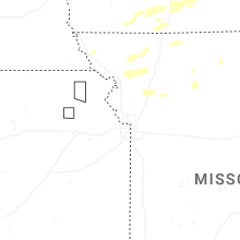
Missouri
| Local Time | Report Details |
|---|---|
| 8:36 AM CDT | Storm damage reported in caldwell county MO, 53.3 miles NE of Kansas City, MO |
| 3:35 PM CDT | Several reports of tree limbs and wires down between princeton and mercer. time estimated from radar. location estimate in mercer county MO, 79.4 miles S of Des Moines, IA |
| 3:35 PM CDT | Quarter sized hail reported near Princeton, MO, 79.4 miles S of Des Moines, IA, social media report. time and location estimated. |
| 3:49 PM CDT | Golf Ball sized hail reported near Paris, MO, 40.6 miles NNE of Columbia, MO, paris mo fire reported golf ball size hail. |
| 4:08 PM CDT | Golf Ball sized hail reported near Princeton, MO, 82.1 miles S of Des Moines, IA, social media report. time estimated from radar. |
| 4:16 PM CDT | Ping Pong Ball sized hail reported near Pattonsburg, MO, 71.9 miles NNE of Kansas City, MO, report from mping: ping pong ball (1.50 in.). |
| 4:35 PM CDT | Quarter sized hail reported near Pattonsburg, MO, 63.5 miles NNE of Kansas City, MO, social media report. time estimated from radar. |
| 4:37 PM CDT | Several trees damaged or downed. time estimated from rada in dekalb county MO, 61.1 miles NNE of Kansas City, MO |
| 4:44 PM CDT | Golf Ball sized hail reported near Pattonsburg, MO, 72.4 miles NNE of Kansas City, MO, golf ball sized hail reported along interstate 35 near pattonsburg. |
| 6:13 PM CDT | Golf Ball sized hail reported near Barnard, MO, 78.1 miles N of Kansas City, MO, report of 1 1/2-2 inch hail. time estimated by radar. |
| 6:17 PM CDT | Downed trees at a residence in rural adair county. time estimated from rada in adair county MO, 63.5 miles WSW of Kahoka, MO |
| 6:30 PM CDT | Social media of downed tree limbs at a residence south of greentop. time estimated from rada in adair county MO, 45.7 miles W of Kahoka, MO |
| 6:33 PM CDT | Private weather senso in adair county MO, 56.8 miles WSW of Kahoka, MO |
| 6:38 PM CDT | Multiple trees down in the millard area. time estimated from rada in adair county MO, 48.9 miles WSW of Kahoka, MO |
| 6:38 PM CDT | Mping report of tree limbs down near kirksville airport. time estimated from rada in adair county MO, 49.2 miles WSW of Kahoka, MO |
| 6:40 PM CDT | Quarter sized hail reported near Kirksville, MO, 49.5 miles WSW of Kahoka, MO, report from mping: quarter (1.00 in.). |
| 6:44 PM CDT | Multiple trees down on the north side of kirksville. time estimated from rada in adair county MO, 47.5 miles WSW of Kahoka, MO |
| 7:15 PM CDT | Ping Pong Ball sized hail reported near Princeton, MO, 88.3 miles S of Des Moines, IA, fire department reported ping pong ball sized hail. report relayed by em. |
| 7:30 PM CDT | Quarter sized hail reported near Princeton, MO, 86.1 miles S of Des Moines, IA, social media report. time estimated from radar. |
| 8:36 PM CDT | Private weather senso in holt county MO, 76.3 miles NNW of Kansas City, MO |
| 8:47 PM CDT | Private weather senso in holt county MO, 78.8 miles NNW of Kansas City, MO |
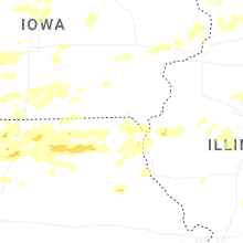
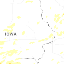
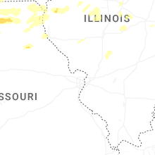
Iowa
| Local Time | Report Details |
|---|---|
| 10:46 AM CDT | Delayed report. peak wind gust from personal weather statio in hardin county IA, 44.2 miles N of Des Moines, IA |
| 10:50 AM CDT | Delayed report. peak wind gust from a personal weather statio in marshall county IA, 46.1 miles NNE of Des Moines, IA |
| 10:57 AM CDT | Delayed report... peak wind gust from the kmiw marshalltown airport aso in marshall county IA, 51.3 miles NE of Des Moines, IA |
| 11:00 AM CDT | Delayed report. peak wind gust from a personal weather statio in hardin county IA, 48.2 miles NNE of Des Moines, IA |
| 11:00 AM CDT | Large tree down in hubbard. time estimated by rada in hardin county IA, 52.3 miles NNE of Des Moines, IA |
| 11:01 AM CDT | Delayed report. peak wind gust from a personal weather statio in hardin county IA, 53.7 miles NNE of Des Moines, IA |
| 11:01 AM CDT | Tree limbs over a foot in diameter were snapped. picture sent via social media. time estimated by rada in jones county IA, 28.2 miles ENE of Cedar Rapids, IA |
| 11:19 AM CDT | Storm damage reported in johnson county IA, 30.4 miles S of Cedar Rapids, IA |
| 11:25 AM CDT | Large tree split in half... taking down powerline in tama county IA, 35.3 miles WNW of Cedar Rapids, IA |
| 11:25 AM CDT | Large tree toppled at my sisters place one and a quarter mile south of frytow in johnson county IA, 30.4 miles S of Cedar Rapids, IA |
| 11:30 AM CDT | Wind gust measured by house anemometer and 1 inch tree limbs down. time estimated by rada in johnson county IA, 24.7 miles SSE of Cedar Rapids, IA |
| 11:35 AM CDT | Tree with 4 to 6 inch diameter trunk snapped at the bas in johnson county IA, 23.9 miles SSE of Cedar Rapids, IA |
| 11:44 AM CDT | Delayed report. peak wind gust from a personal weather statio in black hawk county IA, 35.9 miles NW of Cedar Rapids, IA |
| 11:49 AM CDT | Delayed report. peak wind gust from a personal weather statio in black hawk county IA, 37.6 miles NW of Cedar Rapids, IA |
| 12:07 PM CDT | Power lines down over road near intersection of 215th st and nathan bethel ave. time estimated by rada in buchanan county IA, 35.7 miles NNW of Cedar Rapids, IA |
| 12:14 PM CDT | 2 inch tree limb down. the time of the event was estimated using rada in scott county IA, 61.8 miles ESE of Cedar Rapids, IA |
| 12:15 PM CDT | 10 inch tree limbs reported down in eden valley refuge. time estimated by rada in jackson county IA, 42.2 miles E of Cedar Rapids, IA |
| 12:15 PM CDT | Corrects previous tstm wnd gst report from 1 sse stanwoo in cedar county IA, 28.3 miles ESE of Cedar Rapids, IA |
| 12:15 PM CDT | Storm damage reported in scott county IA, 61.1 miles ESE of Cedar Rapids, IA |
| 12:20 PM CDT | Powerlines leanin in delaware county IA, 40.9 miles NNE of Cedar Rapids, IA |
| 12:30 PM CDT | Tree down near the intersection of county rd 64 and 200th ave. time estimated by rada in delaware county IA, 43.2 miles NNE of Cedar Rapids, IA |
| 12:33 PM CDT | Storm damage reported in jones county IA, 35 miles NE of Cedar Rapids, IA |
| 12:40 PM CDT | Em reports widespread 70-80 mph winds in the area with numerous trees down and power outages. some traffic lights have power out on hwy 2 in dubuque county IA, 62.5 miles NE of Cedar Rapids, IA |
| 12:40 PM CDT | Peak wind gust at dubuque regional airpor in dubuque county IA, 57.5 miles ENE of Cedar Rapids, IA |
| 12:40 PM CDT | Several trees blown down east of peosta. reported by off duty nws employee. the time of the event was estimated using rada in dubuque county IA, 55.1 miles NE of Cedar Rapids, IA |
| 12:42 PM CDT | Tree down 1 mile west of epworth reported by off duty nws employe in dubuque county IA, 49.5 miles NE of Cedar Rapids, IA |
| 12:42 PM CDT | Many small to medium sized branches blown down. a larger size branch causing traffic issues on one downtown street. medium sized tree uprooted in front yard 3 houses fr in dubuque county IA, 61.2 miles NE of Cedar Rapids, IA |
| 12:45 PM CDT | 6 inch tree limbs snapped. time estimated by rada in dubuque county IA, 60.4 miles NE of Cedar Rapids, IA |
| 12:45 PM CDT | Couple trees uprooted along with many branches downed and some fence damage... including along asbury road near bunker hill golf course. time estimated using rada in dubuque county IA, 62.1 miles NE of Cedar Rapids, IA |
| 12:49 PM CDT | Tree branches over a foot in diameter downed. estimated wind gust of 65 mph by car anemomete in clinton county IA, 76.9 miles E of Cedar Rapids, IA |
| 12:50 PM CDT | Branch snapped 6 inch diamete in dubuque county IA, 60 miles NE of Cedar Rapids, IA |
| 12:54 PM CDT | Large spruce tree dow in dubuque county IA, 60 miles NE of Cedar Rapids, IA |
| 12:54 PM CDT | Large tree snapped off near the base. trunk diameter over a foo in dubuque county IA, 60 miles NE of Cedar Rapids, IA |
| 1:04 PM CDT | Spotter estimated winds of 50 to 60 mph with thunderstor in dubuque county IA, 60.4 miles NE of Cedar Rapids, IA |
| 1:11 PM CDT | Widespread large trees dow in dubuque county IA, 56.3 miles NE of Cedar Rapids, IA |
| 2:15 PM CDT | Storm damage reported in cedar county IA, 28.3 miles ESE of Cedar Rapids, IA |
| 4:12 PM CDT | Building damage per em in decatur county IA, 52.4 miles S of Des Moines, IA |
| 4:30 PM CDT | Hen Egg sized hail reported near Weldon, IA, 48 miles S of Des Moines, IA, delayed report - time estimated from radar. received email from media relaying 2 hail in weldon. |
| 5:07 PM CDT | Storm damage reported in wapello county IA, 61.1 miles NW of Kahoka, MO |
| 5:24 PM CDT | Report from trained spotte in davis county IA, 40.1 miles WNW of Kahoka, MO |
| 5:51 PM CDT | Section of a sheet metal roof was ripped off. picture sent via social media. time estimated by rada in cedar county IA, 42.7 miles ESE of Cedar Rapids, IA |
| 6:14 PM CDT | Estimate of 70 mph wit in scott county IA, 61.8 miles ESE of Cedar Rapids, IA |
| 6:17 PM CDT | Several 12 to 15 inch limbs down along with trees 1 to 2 feet in diameter. estimating 80 mph wind in scott county IA, 61.5 miles ESE of Cedar Rapids, IA |
| 6:17 PM CDT | Peak wind gust at the davenport municipal airpor in scott county IA, 61.4 miles ESE of Cedar Rapids, IA |
| 6:18 PM CDT | Measured by anemomete in scott county IA, 61.1 miles ESE of Cedar Rapids, IA |
| 6:32 PM CDT | Estimated wind gust from spotter networ in scott county IA, 72.9 miles ESE of Cedar Rapids, IA |
| 6:47 PM CDT | Tree damage with power lines down. time estimated via rada in warren county IA, 8.3 miles SSW of Des Moines, IA |
| 7:06 PM CDT | Received photo via social media of fallen tree on fence in altoon in polk county IA, 8.3 miles ENE of Des Moines, IA |
| 7:17 PM CDT | Quarter sized hail reported near Dougherty, IA, 20.1 miles SE of Mason City, IA, image via social media. time estimated from radar. |
| 7:32 PM CDT | Quarter sized hail reported near Greene, IA, 26.5 miles SE of Mason City, IA, mping report. |
| 7:41 PM CDT | Multiple trees and power lines down. time estimated via rada in madison county IA, 39.7 miles SW of Des Moines, IA |
| 8:30 PM CDT | Small branches down via social medi in butler county IA, 37 miles SE of Mason City, IA |
| 5:30 AM CDT | Tennis Ball sized hail reported near Clarinda, IA, 54.8 miles SE of Omaha, NE |
| 5:40 AM CDT | Storm damage reported in mills county IA, 17.9 miles SE of Omaha, NE |
| 5:42 AM CDT | Storm damage reported in mills county IA, 26.6 miles SE of Omaha, NE |
| 5:46 AM CDT | Storm damage reported in pottawattamie county IA, 17.1 miles ESE of Omaha, NE |
| 5:47 AM CDT | Storm damage reported in mills county IA, 16.4 miles ESE of Omaha, NE |
| 5:47 AM CDT | Storm damage reported in mills county IA, 13.4 miles SE of Omaha, NE |
| 5:47 AM CDT | Storm damage reported in mills county IA, 20.9 miles SE of Omaha, NE |
| 5:55 AM CDT | Storm damage reported in montgomery county IA, 39.8 miles ESE of Omaha, NE |
| 5:55 AM CDT | Storm damage reported in page county IA, 44.8 miles SE of Omaha, NE |
| 5:56 AM CDT | Trees blocking hwy 48 south of esse in page county IA, 44.8 miles SE of Omaha, NE |
| 6:01 AM CDT | Storm damage reported in page county IA, 46.7 miles SE of Omaha, NE |
| 6:06 AM CDT | Storm damage reported in pottawattamie county IA, 36.5 miles E of Omaha, NE |
| 6:07 AM CDT | 60 mph wind estimated. quarter sized hail and large limbs dow in montgomery county IA, 42.2 miles SE of Omaha, NE |
| 6:12 AM CDT | Storm damage reported in montgomery county IA, 51.5 miles ESE of Omaha, NE |
| 6:13 AM CDT | Storm damage reported in page county IA, 52.3 miles ESE of Omaha, NE |
| 6:14 AM CDT | Storm damage reported in montgomery county IA, 54.6 miles ESE of Omaha, NE |
| 6:18 AM CDT | Measured from personal weather statio in cass county IA, 41.7 miles E of Omaha, NE |
| 6:31 AM CDT | Storm damage reported in page county IA, 63.1 miles SE of Omaha, NE |
| 6:34 AM CDT | Quarter sized hail reported near Clarinda, IA, 60.1 miles SE of Omaha, NE, report from mping: quarter (1.00 in.). |
| 6:45 AM CDT | Quarter sized hail reported near Creston, IA, 53.3 miles SW of Des Moines, IA |
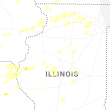
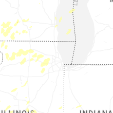
Illinois
| Local Time | Report Details |
|---|---|
| 11:15 AM CDT | Narrow tree damage path between riverton and sherman. strong winds went multiple direction in sangamon county IL, 56.7 miles S of Peoria, IL |
| 12:50 PM CDT | Few dozen trees and wires down. a couple houses have been hit by falling tree in jo daviess county IL, 70.1 miles SW of Madison, WI |
| 12:54 PM CDT | Several dozen small branches down... some larg in jo daviess county IL, 69.2 miles SW of Madison, WI |
| 1:06 PM CDT | Peak wind gust measured by coop observer. time estimated by rada in jo daviess county IL, 55.7 miles SSW of Madison, WI |
| 1:35 PM CDT | Measured on personal weather statio in ogle county IL, 76.1 miles S of Madison, WI |
| 1:39 PM CDT | Large limb came down and is blocking the southbound lan in stephenson county IL, 49.4 miles SSW of Madison, WI |
| 1:45 PM CDT | Large tree limbs downed over powerlines. picture sent via social media. time estimated by rada in stephenson county IL, 41 miles S of Madison, WI |
| 1:53 PM CDT | Storm damage reported in fulton county IL, 21.7 miles W of Peoria, IL |
| 1:53 PM CDT | Power pole and lines dow in fulton county IL, 21.7 miles W of Peoria, IL |
| 2:10 PM CDT | Peak gust measured on personal weather station. time estimated from rada in ogle county IL, 79.8 miles S of Madison, WI |
| 2:11 PM CDT | Several trees down... including wires on rice roa in peoria county IL, 16.8 miles NNW of Peoria, IL |
| 2:16 PM CDT | Large tree branch down. time estimated by rada in peoria county IL, 6.2 miles N of Peoria, IL |
| 2:21 PM CDT | Several trees dow in peoria county IL, 16.5 miles NNE of Peoria, IL |
| 2:21 PM CDT | Large tree downed on north timber circle. time estimated from rada in peoria county IL, 3.4 miles NNE of Peoria, IL |
| 2:24 PM CDT | Storm damage reported in tazewell county IL, 3.6 miles S of Peoria, IL |
| 2:25 PM CDT | Flag pole snappe in marshall county IL, 21 miles NNE of Peoria, IL |
| 2:29 PM CDT | Downed tree limbs in lacon. time estimated by rada in marshall county IL, 25.1 miles NNE of Peoria, IL |
| 2:33 PM CDT | Tree down near pekin country clu in tazewell county IL, 7.7 miles S of Peoria, IL |
| 2:33 PM CDT | 12 inch tree limb dow in tazewell county IL, 8.9 miles SSW of Peoria, IL |
| 2:33 PM CDT | Large tree downed in pekin. photos relayed by e in tazewell county IL, 9.5 miles SSW of Peoria, IL |
| 2:33 PM CDT | 3 inch diameter tree limb down. time estimated by rada in boone county IL, 62.9 miles SSE of Madison, WI |
| 2:34 PM CDT | Personal weather station measured 60 mph wind gusts as the storms pass throug in lee county IL, 71.2 miles NNE of Peoria, IL |
| 2:39 PM CDT | Personal weather station measured as the line of storms moved throug in boone county IL, 58.2 miles SSE of Madison, WI |
| 2:40 PM CDT | Time estimated by rada in marshall county IL, 32.5 miles NE of Peoria, IL |
| 2:45 PM CDT | Personal weather station 3.8 nnw of leland... il measured wind gust as line of storms moved throug in de kalb county IL, 61.8 miles WSW of Chicago, IL |
| 2:50 PM CDT | Trained spotter measured wind gust at rt 176 and franklinville road east of marengo. time estimated by rada in mchenry county IL, 51.7 miles WNW of Chicago, IL |
| 2:53 PM CDT | 8 to 10 inch tree limbs down. time estimated by rada in tazewell county IL, 12.9 miles SSE of Peoria, IL |
| 2:55 PM CDT | Report via social media of a tree branch broken and fell on power lines along walker road north of allen road nw of hampshire. time estimated by rada in kane county IL, 50.7 miles WNW of Chicago, IL |
| 2:57 PM CDT | Photo shared to social media shows a semi trailer tipped over along i-88 at county line road south of maple park. time estimated by rada in kane county IL, 49.9 miles W of Chicago, IL |
| 2:58 PM CDT | Photos sent by local em of roof damage to a farm building. time estimated by rada in kane county IL, 47.8 miles W of Chicago, IL |
| 3:00 PM CDT | Photos shared to office email account depicted snapped willow trees... single damage... and damage to a barn. in addition... power poles were reported down in the gener in kane county IL, 46.8 miles W of Chicago, IL |
| 3:02 PM CDT | Large branches downed. time estimated from rada in mchenry county IL, 44.9 miles WNW of Chicago, IL |
| 3:06 PM CDT | Peak gust measured on personal weather statio in la salle county IL, 61 miles NE of Peoria, IL |
| 3:07 PM CDT | Photo via social media of trees and power lines down on bliss road in sugar grove. time estimated by rada in kane county IL, 42.2 miles W of Chicago, IL |
| 3:07 PM CDT | Large main limb of a tree... at least 12 inches in diameter snapped. time estimated by rada in kane county IL, 40.2 miles W of Chicago, IL |
| 3:10 PM CDT | Wind gust measured at kar in kane county IL, 43.9 miles W of Chicago, IL |
| 3:10 PM CDT | Maple tree snapped in half. time estimated from rada in kane county IL, 40 miles WNW of Chicago, IL |
| 3:11 PM CDT | Report of multiple trees with broken branches near il-64 and dean street between campton hills and st charles. time estimated by rada in kane county IL, 38.7 miles W of Chicago, IL |
| 3:13 PM CDT | Large barn collapsed along granart road south of jericho road near little rock. numerous large branches broken nearby. time estimated by rada in kane county IL, 48.6 miles WSW of Chicago, IL |
| 3:14 PM CDT | Photos shared to social media show multiple branches broken... one tree snapped... a collapsed farm outbuilding... a leaning power pole... and flattened crops along jon in kane county IL, 47.6 miles WSW of Chicago, IL |
| 3:14 PM CDT | Photo via social media of large tree across jericho road. time estimated by rada in kane county IL, 45 miles WSW of Chicago, IL |
| 3:14 PM CDT | Personal weather system observatio in woodford county IL, 28.5 miles E of Peoria, IL |
| 3:15 PM CDT | Peak gust measured on personal weather statio in kane county IL, 41.5 miles WNW of Chicago, IL |
| 3:15 PM CDT | Report via social media of multiple large branches broken... largest 10 inches in diamete in kane county IL, 46.9 miles WSW of Chicago, IL |
| 3:18 PM CDT | Photos relayed of over 6 inch diameter branches down. time estimated by rada in kane county IL, 36.6 miles WNW of Chicago, IL |
| 3:19 PM CDT | Roof blown off of an outbuilding. time estimated from rada in grundy county IL, 53.9 miles SW of Chicago, IL |
| 3:20 PM CDT | Tree downed onto road. another branch of another tree also downed onto the road. time estimated from rada in kane county IL, 37.2 miles WNW of Chicago, IL |
| 3:21 PM CDT | Multiple poles downed along il-47 just north of joliet road between lisbon township building and joliet road. time estimated by rada in kendall county IL, 49.4 miles WSW of Chicago, IL |
| 3:25 PM CDT | Tree down blocking the road around 0.5 miles south of il-126 on schlapp rd. time estimated from rada in kendall county IL, 40.6 miles WSW of Chicago, IL |
| 3:28 PM CDT | Lines and trees down. time estimated by rada in kendall county IL, 43.6 miles SW of Chicago, IL |
| 3:29 PM CDT | Peak gust measured on personal weather statio in grundy county IL, 53.1 miles SW of Chicago, IL |
| 3:29 PM CDT | Trees and power lines dow in mclean county IL, 42.6 miles E of Peoria, IL |
| 3:30 PM CDT | 60 to 65 mph estimated wind gusts. time estimated by rada in dupage county IL, 24.7 miles WSW of Chicago, IL |
| 3:30 PM CDT | Peak gust measured on personal weather statio in will county IL, 36.5 miles WSW of Chicago, IL |
| 3:30 PM CDT | 3 inch diameter tree downed onto roa in dupage county IL, 28.8 miles W of Chicago, IL |
| 3:30 PM CDT | Numerous tree limbs of varying sizes downed in the general area. a one foot diameter tree branch downed on lisson road blocking southbound traffic. estimated 60 to 65 m in dupage county IL, 26.1 miles WSW of Chicago, IL |
| 3:30 PM CDT | Multiple trees downed. fences downed as wel in will county IL, 39.5 miles SW of Chicago, IL |
| 3:32 PM CDT | Trees down... fascia blown off... and siding damag in will county IL, 33.4 miles WSW of Chicago, IL |
| 3:32 PM CDT | Multiple reports of trees and power lines downed in barrington and barrington hills. time estimated from rada in cook county IL, 31.5 miles NW of Chicago, IL |
| 3:32 PM CDT | Photo emailed in of a small tree down. time estimated by rada in will county IL, 40.7 miles SW of Chicago, IL |
| 3:34 PM CDT | Multiple photos shared to social media show large tree branches broken across western portions of joliet. time estimated by rada in will county IL, 36.2 miles SW of Chicago, IL |
| 3:34 PM CDT | Personal weather station measured wind gust. time estimated by rada in kendall county IL, 41.1 miles WSW of Chicago, IL |
| 3:35 PM CDT | Spotter reported structural damage as siding has been ripped off buildings as strong wind gusts came through. small tree limbs are down as wel in lake county IL, 47.6 miles NNW of Chicago, IL |
| 3:35 PM CDT | Tree downed onto apartment building. time estimated from rada in cook county IL, 24.8 miles WNW of Chicago, IL |
| 3:36 PM CDT | Power lines downed. time estimated from rada in cook county IL, 25.8 miles WNW of Chicago, IL |
| 3:36 PM CDT | 60 to 70 mph estimated wind gusts with small branches dow in will county IL, 35.5 miles WSW of Chicago, IL |
| 3:36 PM CDT | Reports of roadways blocked due to broken branches in plainfield and crest hill. telephone pole damaged near us30 and larkin. time estimated by rada in will county IL, 34.5 miles SW of Chicago, IL |
| 3:36 PM CDT | Photo via social media of 8 to 10 inch tree limb down. time estimated by rada in will county IL, 32.6 miles SW of Chicago, IL |
| 3:36 PM CDT | Large mature tree downed across raynor avenue at glenwood avenue. time estimated from rada in will county IL, 34.4 miles SW of Chicago, IL |
| 3:37 PM CDT | Photo via social media shows large branch broken. time estimated by rada in will county IL, 33.4 miles SW of Chicago, IL |
| 3:37 PM CDT | Tree downed onto power lines. time estimated from rada in cook county IL, 29.5 miles WNW of Chicago, IL |
| 3:37 PM CDT | Large tree branch down on six points rd. just west of juniper l in mclean county IL, 33.9 miles ESE of Peoria, IL |
| 3:38 PM CDT | Tree downed onto power lines. time estimated from rada in cook county IL, 29.1 miles NW of Chicago, IL |
| 3:38 PM CDT | Forest preserve district of dupage county reports multiple tree branches broken in mcdowell grove forest preserve near naperville. time estimated by rada in dupage county IL, 29 miles WSW of Chicago, IL |
| 3:39 PM CDT | Wires downed in multiple locations across elk grove village. time estimated from rada in cook county IL, 20.2 miles WNW of Chicago, IL |
| 3:39 PM CDT | Tree downed onto power lines. time estimated from rada in cook county IL, 27.7 miles WNW of Chicago, IL |
| 3:39 PM CDT | Peak wind gust reported at klo in will county IL, 30.7 miles SW of Chicago, IL |
| 3:39 PM CDT | Photos shared to social media show branches broken in wood dale. time estimated by rada in dupage county IL, 18.9 miles WNW of Chicago, IL |
| 3:40 PM CDT | Photo shared to social media shows interstate road sign blown down along i-55 just west of veterans parkway. time estimated by rada in will county IL, 28.8 miles WSW of Chicago, IL |
| 3:40 PM CDT | Photo via social media of a large branch snapped off a tree. time estimated by rada in grundy county IL, 52.3 miles SW of Chicago, IL |
| 3:40 PM CDT | Reports of power lines down and four inch diameter tree branches down. time estimated by rada in dupage county IL, 27.5 miles WSW of Chicago, IL |
| 3:42 PM CDT | Large tree branch down on a car. time estimated by rada in dupage county IL, 27 miles WSW of Chicago, IL |
| 3:42 PM CDT | 20 year old tree blocking the intersection. time estimated by rada in dupage county IL, 26.4 miles WSW of Chicago, IL |
| 3:42 PM CDT | Large tree limbs downed. patio furniture also blown around. time estimated from rada in will county IL, 28.1 miles WSW of Chicago, IL |
| 3:42 PM CDT | Tree downed onto road in waukegan. time estimated from rada in lake county IL, 34.4 miles NNW of Chicago, IL |
| 3:42 PM CDT | Numerous reports of tree damage across various parts of napervill in dupage county IL, 27.9 miles WSW of Chicago, IL |
| 3:42 PM CDT | Weber road closed between boughton road and washington street due to downed power lines. relayed by village of bolingbrook social media. time estimated by rada in will county IL, 28.4 miles WSW of Chicago, IL |
| 3:44 PM CDT | Multiple reports of trees and power lines downed in buffalo grove. time estimated from rada in lake county IL, 25.4 miles NW of Chicago, IL |
| 3:45 PM CDT | Multiple public reports of downed trees and large tree limbs across homer gle in will county IL, 24.2 miles SW of Chicago, IL |
| 3:45 PM CDT | Peak gust measured on personal weather statio in will county IL, 25.7 miles SW of Chicago, IL |
| 3:45 PM CDT | Tree branches reported down. time estimated by rada in will county IL, 33.7 miles SW of Chicago, IL |
| 3:45 PM CDT | Corrects previous tstm wnd dmg report from 1 nne homer glen. personal weather station measured 65 mph wind gust. time estimated by rada in will county IL, 24.4 miles SW of Chicago, IL |
| 3:47 PM CDT | 14 inch diameter tree downe in cook county IL, 22.4 miles SW of Chicago, IL |
| 3:47 PM CDT | Multiple reports of trees and power lines downed in palatine. time estimated from rada in cook county IL, 26.1 miles NW of Chicago, IL |
| 3:48 PM CDT | Multiple reports of trees and power lines downed in arlington heights. time estimated from rada in cook county IL, 22.4 miles NW of Chicago, IL |
| 3:49 PM CDT | Multiple reports of trees and power lines downed in mount prospect. time estimated from rada in cook county IL, 20.4 miles NW of Chicago, IL |
| 3:49 PM CDT | Peak wind gust measured at kor in cook county IL, 15.3 miles WNW of Chicago, IL |
| 3:51 PM CDT | Photo via social media shows uprooted evergreen tree. time estimated by rada in will county IL, 30 miles SW of Chicago, IL |
| 3:52 PM CDT | Large diameter tree damage in palos park... specifically in an area from 123rd to the north. time approximated by rada in cook county IL, 18.3 miles SSW of Chicago, IL |
| 3:52 PM CDT | Photos emailed of snapped trees during the afternoon wind surge. time estimated by rada in cook county IL, 23.2 miles SSW of Chicago, IL |
| 3:52 PM CDT | Multiple reports of trees and power lines downed in wheeling. time estimated from rada in cook county IL, 23.4 miles NW of Chicago, IL |
| 3:53 PM CDT | Multiple branches broken in the brookfield area. time estimated by rada in cook county IL, 12.1 miles WSW of Chicago, IL |
| 3:54 PM CDT | 5 inch diameter tree broken about a foot above the base. time estimated from rada in cook county IL, 11.4 miles WSW of Chicago, IL |
| 3:55 PM CDT | Several large trees and power lines down. notably... a 30 inch diameter hickory tree. time estimated by rada in cook county IL, 14.8 miles SSW of Chicago, IL |
| 3:55 PM CDT | Social media pictures of assorted branches down... specifically between 99th to 102nd street and 52nd to 54th avenues. time estimated by rada in cook county IL, 12.9 miles SSW of Chicago, IL |
| 3:55 PM CDT | Road closures due to tree damage in the brookfield area. time estimated from rada in cook county IL, 11.3 miles WSW of Chicago, IL |
| 3:55 PM CDT | Local broadcast media reports that the roof of five story apartment building was torn off. time estimated by rada in cook county IL, 8.5 miles WSW of Chicago, IL |
| 3:56 PM CDT | Power lines downed near 151st street and laramie avenue. time estimated from rada in cook county IL, 19.2 miles SSW of Chicago, IL |
| 3:56 PM CDT | Corrects previous tstm wnd dmg report from 1 sse oak forest. power lines downed near 167th street and cicero avenue. time estimated from rada in cook county IL, 21 miles SSW of Chicago, IL |
| 3:56 PM CDT | Corrects previous tstm wnd dmg report from 1 sse oak forest. power lines downed near 167th street and cicero avenue. time estimated from rada in cook county IL, 21 miles SSW of Chicago, IL |
| 3:56 PM CDT | 3 foot diameter tree limb snapped off of tree and flag pole bent. time estimated from rada in cook county IL, 13.4 miles SSW of Chicago, IL |
| 3:56 PM CDT | Photo via social media shows a few shingles removed measured from apartment buildings. time estimated by rada in cook county IL, 23.3 miles SSW of Chicago, IL |
| 3:57 PM CDT | Tree and power lines downed. time estimated from rada in cook county IL, 11.9 miles SSW of Chicago, IL |
| 3:57 PM CDT | 8 to 10 inch diameter branch downed onto road. time estimated from rada in cook county IL, 18 miles SSW of Chicago, IL |
| 3:58 PM CDT | 5 inch tree limbs down near foster and newcastle. time estimated by rada in cook county IL, 11.7 miles NNW of Chicago, IL |
| 3:58 PM CDT | Photos shared to social media show numerous large branches broken near vittum park in garfield ridge community area of chicago. time estimated by rada in cook county IL, 8.4 miles SW of Chicago, IL |
| 3:58 PM CDT | Large tree down in the 4400 block of s kno in cook county IL, 7.5 miles SW of Chicago, IL |
| 3:58 PM CDT | Asos station kmdw chicago midwa in cook county IL, 9.7 miles SW of Chicago, IL |
| 3:58 PM CDT | Multiple reports of tree branches downed in oak park... including a large tree uprooted near 96th street and 50th that landed on a car. time estimated by rada in cook county IL, 8.1 miles W of Chicago, IL |
| 4:00 PM CDT | Personal weather station measured strong wind gusts. time estimated by rada in cook county IL, 16 miles NNW of Chicago, IL |
| 4:00 PM CDT | Tree uprooted... numerous branches around one inch diameter broken in the neighborhood. siding removed from a nearby house. time estimated by rada in cook county IL, 11.6 miles SSW of Chicago, IL |
| 4:00 PM CDT | Pine tree downe in kankakee county IL, 60.9 miles SSW of Chicago, IL |
| 4:00 PM CDT | Video shared on social media shows 2 foot diameter tree uprooted with entire root ball destroying nearby pavement. the tree fell on and destroyed a garage. time estimat in cook county IL, 14.6 miles SSW of Chicago, IL |
| 4:01 PM CDT | Photos shared on social media show extensive tree damage on the south end of lincoln park including uprooted oak tree in cook county IL, 2.6 miles NNW of Chicago, IL |
| 4:02 PM CDT | Photos shared to social media show multiple large branches broken near 23rd street and rockwell street in the south lawndale community area of chicago. one tree snapped in cook county IL, 5 miles SW of Chicago, IL |
| 4:04 PM CDT | Windows blown out of a high ris in cook county IL, 1 miles S of Chicago, IL |
| 4:04 PM CDT | Tree downed onto a power line in clinton. relayed by e in de witt county IL, 49.4 miles SE of Peoria, IL |
| 4:05 PM CDT | Reports of estimated 18 inch diameter trees dow in cook county IL, 11.4 miles SSW of Chicago, IL |
| 4:05 PM CDT | Photo shared to social media shows large tree branch downed near hubbard street and aberdeen street in west town community area of chicago. time estimated by rada in cook county IL, 1.5 miles WNW of Chicago, IL |
| 4:05 PM CDT | Photo shared on social media depicts a roughly 50 foot softwood tree snapped a few feed up from the ground. time estimated by rada in cook county IL, 7.7 miles SSE of Chicago, IL |
| 4:06 PM CDT | Peak gust measured on private weather station. time estimated from rada in cook county IL, 2 miles SE of Chicago, IL |
| 4:06 PM CDT | Peak gust measured on personal weather statio in cook county IL, 6.9 miles SSE of Chicago, IL |
| 4:06 PM CDT | Photos and videos shared to social media show multiple large branches broken in the lake view community area of chicago. time estimated by rada in cook county IL, 4 miles NNW of Chicago, IL |
| 4:07 PM CDT | Peak gust measured on personal weather statio in cook county IL, 3.9 miles N of Chicago, IL |
| 4:08 PM CDT | Peak gust measured at the harrison-dever cri in lmz741 county IL, 4.1 miles NE of Chicago, IL |
| 4:09 PM CDT | Photos shared to social media show multiple large branches broken near cornelia avenue and southport avenue in the lakeview community area of chicago. time estimated by in cook county IL, 4.8 miles NNW of Chicago, IL |
| 4:09 PM CDT | Peak gust measured on personal weather statio in cook county IL, 0.6 miles NW of Chicago, IL |
| 4:09 PM CDT | Peak gust measured on personal weather statio in cook county IL, 3.5 miles NW of Chicago, IL |
| 4:09 PM CDT | Peak gust measured on personal weather statio in cook county IL, 1.8 miles NW of Chicago, IL |
| 4:09 PM CDT | Peak gust measured on personal weather statio in kankakee county IL, 50.3 miles SSW of Chicago, IL |
| 4:10 PM CDT | Large tree downed onto montrose avenue. time estimated from rada in cook county IL, 5.3 miles N of Chicago, IL |
| 4:10 PM CDT | Numerous large tree branches downed onto cullerton street... damaging several cars. power lines were also downe in cook county IL, 1.8 miles SSE of Chicago, IL |
| 4:13 PM CDT | Tree limbs downed. 56 mph gust measured at this location as wel in kankakee county IL, 41 miles S of Chicago, IL |
| 5:03 PM CDT | Half Dollar sized hail reported near Harvel, IL, 61.8 miles NE of Saint Louis, MO, corrects previous hail report from 2 ese harvel. size estimated from picture. |
| 5:03 PM CDT | 8-12in diameter tree limbs snappe in montgomery county IL, 61.8 miles NE of Saint Louis, MO |
| 6:09 PM CDT | Half Dollar sized hail reported near Harvel, IL, 61.8 miles NE of Saint Louis, MO, size estimated from picture. |
| 6:40 PM CDT | Multiple powerlines down off of east wolf road. tornado possible. time estimated by rada in henry county IL, 63 miles NNW of Peoria, IL |
| 6:49 PM CDT | Measured by roof mounted anemomete in henry county IL, 55.3 miles NNW of Peoria, IL |
| 6:50 PM CDT | 4 to 8 inch diameter tree limb blown down. time of the event estimated using rada in henry county IL, 57.5 miles NNW of Peoria, IL |
| 7:13 PM CDT | Measured on a personal weather statio in bureau county IL, 60.7 miles N of Peoria, IL |
| 7:50 PM CDT | Storm damage reported in la salle county IL, 68.1 miles NNE of Peoria, IL |
| 7:59 PM CDT | Storm damage reported in de kalb county IL, 61.8 miles WSW of Chicago, IL |
| 8:01 PM CDT | Flooding reported on west carl sandberg drive in galesburg with one car flooded/disable in knox county IL, 44.7 miles WNW of Peoria, IL |
| 8:34 PM CDT | 59 mph wind gust measured at ema building in roanok in woodford county IL, 21.7 miles ENE of Peoria, IL |
| 8:42 PM CDT | Power pole and lines blown down at 2049 county road 700n in benso in woodford county IL, 26.9 miles ENE of Peoria, IL |
| 9:06 PM CDT | Corrects previous tstm wnd dmg report from secor. several trees blown down in secor. anywhere from 8-10 inch diameter size trees blown dow in woodford county IL, 23.7 miles E of Peoria, IL |
| 9:06 PM CDT | Corrects previous tstm wnd dmg report from secor. several trees blown down in secor. anywhere from 8-10 inch diameter size trees blown dow in woodford county IL, 23.7 miles E of Peoria, IL |
| 10:50 PM CDT | Multiple sheds completely destroyed... utility poles missing... 30 foot grain bin destroyed and blown into a house. possible tornad in menard county IL, 52.3 miles SSW of Peoria, IL |
| 10:52 PM CDT | Heavy tree damage at lincolns new salem state par in menard county IL, 51 miles SSW of Peoria, IL |
| 11:05 PM CDT | Trees and power poles down on taintor rd along the north edge of the state fairground in sangamon county IL, 58.9 miles S of Peoria, IL |
| 11:05 PM CDT | Debris from a metal building blown on both sides of highway 29 at the airport entranc in sangamon county IL, 58.9 miles S of Peoria, IL |
| 11:07 PM CDT | Tree blown down on a power line with broken power pol in menard county IL, 51 miles S of Peoria, IL |
| 11:07 PM CDT | Power lines blown down in petersbur in menard county IL, 49.1 miles SSW of Peoria, IL |
| 11:10 PM CDT | Trees and power poles and lines blown down at 8th street and taintor raod on north side of il state fairgrounds in springfiel in sangamon county IL, 58.9 miles S of Peoria, IL |
| 11:12 PM CDT | Trees blown dow in menard county IL, 51 miles S of Peoria, IL |
| 11:12 PM CDT | Power lines down on sangamon av in sangamon county IL, 59.5 miles S of Peoria, IL |
| 11:14 PM CDT | Part of a metal building had its roof collapse in sangamon county IL, 59.5 miles S of Peoria, IL |
| 11:18 PM CDT | Trees blown down and metal on a road near riverto in sangamon county IL, 58.2 miles S of Peoria, IL |
| 11:20 PM CDT | Power pole blown down with tree branches on north 5th street in springfiel in sangamon county IL, 58.9 miles S of Peoria, IL |
| 11:20 PM CDT | Multiple trees down on route 97 in petersbur in menard county IL, 49.1 miles SSW of Peoria, IL |
| 11:28 PM CDT | Tree blown over and blocking highway 54 just east of the logan dewitt county lin in de witt county IL, 49 miles SSE of Peoria, IL |
| 11:29 PM CDT | Multiple power lines blown dow in sangamon county IL, 59.1 miles WNW of Mattoon, IL |
| 11:33 PM CDT | Trees and power lines blown down on 600 block of north madison street in lincol in logan county IL, 39.3 miles SSE of Peoria, IL |
| 11:40 PM CDT | Trees and power lines blown down in maro in macon county IL, 49.2 miles NW of Mattoon, IL |
| 11:44 PM CDT | Three power poles blown down at 2000 ave and 700 st in latha in logan county IL, 53.7 miles NW of Mattoon, IL |
| 11:45 PM CDT | Trees blown down at chatham road at seven pines... jefferson at first st... livingston and cook st... 5th and sangamo in sangamon county IL, 61.6 miles S of Peoria, IL |
| 11:48 PM CDT | Trees and power lines blown donw in orean in macon county IL, 41.2 miles NW of Mattoon, IL |
| 11:50 PM CDT | Powerline blown down in blue moun in macon county IL, 42.5 miles WNW of Mattoon, IL |
| 11:50 PM CDT | Several trees blown down in argent in macon county IL, 41.7 miles NW of Mattoon, IL |
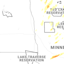
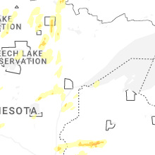
Minnesota
| Local Time | Report Details |
|---|---|
| 12:13 PM CDT | Tree down across the road... with a few other small branches down in the are in goodhue county MN, 52.2 miles SE of Minneapolis, MN |
| 4:20 PM CDT | Quarter sized hail reported near Solway, MN, 11.8 miles SW of Bemidji, MN, hail is ongoing at time of report. many smaller stones but some up to the size of a quarter. |
| 4:37 PM CDT | Golf Ball sized hail reported near Glenwood, MN, 50.8 miles NNE of Montevideo, MN, county dispatch relayed report of golf ball sized hail in glenwood. |
| 4:38 PM CDT | Half Dollar sized hail reported near Villard, MN, 56.7 miles NNE of Montevideo, MN, photo report via facebook. |
| 4:38 PM CDT | Hen Egg sized hail reported near Glenwood, MN, 50.8 miles NNE of Montevideo, MN, photo report via x. |
| 4:40 PM CDT | Tennis Ball sized hail reported near Villard, MN, 56.7 miles NNE of Montevideo, MN, delayed photo report of tennis ball sized hail in villard. |
| 4:40 PM CDT | Ping Pong Ball sized hail reported near Deer Creek, MN, 77.8 miles ESE of Fargo, ND |
| 4:42 PM CDT | Hen Egg sized hail reported near Wadena, MN, 72.4 miles S of Bemidji, MN, photos received of multiple 2 inch hailstones... with many more around a golf ball in size. |
| 4:42 PM CDT | Hen Egg sized hail reported near Wadena, MN, 72.5 miles S of Bemidji, MN, smaller hail mixed in. |
| 4:43 PM CDT | Half Dollar sized hail reported near Rochester, MN, 62.6 miles WNW of La Crosse, WI |
| 4:45 PM CDT | Quarter sized hail reported near Rochester, MN, 62.6 miles WNW of La Crosse, WI |
| 4:45 PM CDT | Golf Ball sized hail reported near Wadena, MN, 72.4 miles S of Bemidji, MN, smaller hail mixed in. |
| 4:50 PM CDT | Hen Egg sized hail reported near Wadena, MN, 72.5 miles S of Bemidji, MN |
| 5:00 PM CDT | Golf Ball sized hail reported near Sebeka, MN, 57.8 miles S of Bemidji, MN, ping pong to golf ball sized hail. |
| 5:42 PM CDT | Quarter sized hail reported near Wyoming, MN, 27.3 miles NNE of Minneapolis, MN, time estimated from radar. |
| 5:44 PM CDT | Image of a tree down via social media. time estimated from rada in winona county MN, 31.4 miles NW of La Crosse, WI |
| 5:44 PM CDT | Received an image of a large tree uprooted near the lake park lodge in winona. time estimated from rada in winona county MN, 24.9 miles NW of La Crosse, WI |
| 5:45 PM CDT | Couple trees dow in winona county MN, 26.1 miles NW of La Crosse, WI |
| 5:50 PM CDT | Quarter sized hail reported near Bena, MN, 36.3 miles ESE of Bemidji, MN |
| 5:50 PM CDT | Quarter sized hail reported near Chisago City, MN, 28.7 miles NNE of Minneapolis, MN |
| 5:55 PM CDT | Half Dollar sized hail reported near Lindstrom, MN, 35.2 miles NE of Minneapolis, MN, photo report via facebook. |
| 5:56 PM CDT | Half Dollar sized hail reported near Lindstrom, MN, 35.2 miles NE of Minneapolis, MN, half dollar hail near the intersection of highway 8 and olinda trail. |
| 5:57 PM CDT | Half Dollar sized hail reported near Chisago City, MN, 32.6 miles NE of Minneapolis, MN |
| 5:59 PM CDT | Golf Ball sized hail reported near Chisago City, MN, 32.6 miles NE of Minneapolis, MN |
| 6:12 PM CDT | Quarter sized hail reported near Taylors Falls, MN, 41.4 miles NE of Minneapolis, MN |
| 6:50 PM CDT | Quarter sized hail reported near Orr, MN, 37.2 miles SSE of International Falls, MN, strong winds but no evidence of wind damage. |
| 7:15 PM CDT | Quarter sized hail reported near Bovey, MN, 63.8 miles WNW of Duluth, MN, half inch hail with a few hailstones up to one inch in diameter. |
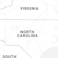
Virginia
| Local Time | Report Details |
|---|---|
| 1:21 PM EDT | Several trees were downed by thunderstorm winds on clover creek road... and multiple large limbs. one tree fell across the roa in bedford county VA, 24.7 miles ESE of Roanoke, VA |
| 1:51 PM EDT | One tree down along cartersville road near its intersection with coles creek lane. time estimated from rada in buckingham county VA, 35.8 miles WNW of Richmond, VA |
| 2:45 PM EDT | Large tree limb hanging in power lines on hodnetts mill road. time estimated from rada in pittsylvania county VA, 42.6 miles SE of Roanoke, VA |
| 3:19 PM EDT | Corrects previous tstm wnd dmg report from 5 e keeling. tree down on power lines down along kentuck roa in pittsylvania county VA, 55.6 miles SE of Roanoke, VA |
| 4:00 PM EDT | Downed trees and power lines. time is estimated from rada in mecklenburg county VA, 56.9 miles N of Raleigh, NC |
| 5:36 PM EDT | Mesonet station wdsv2 willoughby deguassing station gusted to 53 kt (61 mph in anz639 county VA, 21.2 miles NW of Virginia Beach, VA |
New York
| Local Time | Report Details |
|---|---|
| 3:49 PM EDT | Report of a tree and wires downed. delayed repor in cayuga county NY, 20.9 miles W of Syracuse, NY |
| 11:40 PM EDT | Tree down across route 394. southbound lane blocke in chautauqua county NY, 53.1 miles SW of Buffalo, NY |
| 11:50 PM EDT | Tree down in bust in chautauqua county NY, 61.9 miles SSW of Buffalo, NY |
Pennsylvania
| Local Time | Report Details |
|---|---|
| 4:00 PM EDT | Tree down in roadwa in york county PA, 59.7 miles NNW of Baltimore, MD |
| 4:29 PM EDT | Large tree down across entire roadwa in york county PA, 51.3 miles N of Baltimore, MD |
| 10:54 PM EDT | Trees down in lawrence park townshi in erie county PA, 77.7 miles SW of Buffalo, NY |
| 11:00 PM EDT | Trees down in harborcreek townshi in erie county PA, 74.1 miles SW of Buffalo, NY |
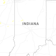
Indiana
| Local Time | Report Details |
|---|---|
| 4:10 PM CDT | Minor shingle damage also reporte in lake county IN, 18 miles SSE of Chicago, IL |
| 4:15 PM CDT | Peak gust measured on personal weather statio in lake county IN, 15.4 miles SSE of Chicago, IL |
| 4:16 PM CDT | Multiple trees downed in whitin in lake county IN, 15.4 miles SSE of Chicago, IL |
| 5:10 PM CDT | Peak gust measured on personal weather statio in porter county IN, 56.3 miles SE of Chicago, IL |
| 6:12 PM EDT | Peak gust measured on personal weather statio in benton county IN, 86.4 miles NW of Indianapolis, IN |
| 5:18 PM CDT | Starke county airpor in starke county IN, 63.2 miles SE of Chicago, IL |
| 5:20 PM CDT | Storm damage reported in la porte county IN, 56.2 miles ESE of Chicago, IL |
| 6:40 PM EDT | Several trees downed in the plymouth are in marshall county IN, 65.7 miles WNW of Fort Wayne, IN |
| 6:54 PM EDT | Quarter sized hail reported near Lafayette, IN, 58 miles NW of Indianapolis, IN |
| 7:00 PM EDT | Powerlines downe in fulton county IN, 58 miles W of Fort Wayne, IN |
| 7:00 PM EDT | Powerlines dow in marshall county IN, 54.9 miles WNW of Fort Wayne, IN |
| 7:15 PM EDT | Warsaw municipal airpor in kosciusko county IN, 40.9 miles WNW of Fort Wayne, IN |
| 7:15 PM EDT | Goshen municipal airpor in elkhart county IN, 48.1 miles NW of Fort Wayne, IN |
| 7:55 PM EDT | Several trees down reported in south kokomo. time estimated from rada in howard county IN, 48.5 miles N of Indianapolis, IN |
Texas
| Local Time | Report Details |
|---|---|
| 4:30 PM CDT | Pecos fire dept reported that a semi was overturned and another jackknifed on interstate 20 near mile marker 33. time estimated from rada in reeves county TX, 70.4 miles N of Alpine, TX |
| 5:36 PM CDT | Mesonet station 167 toyahvale 13w recorded a wind gust of 64 mp in jeff davis county TX, 46.5 miles NNW of Alpine, TX |
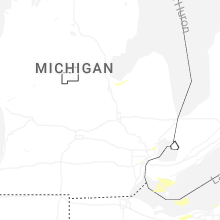
Michigan
| Local Time | Report Details |
|---|---|
| 5:58 PM EDT | Mesonet station xstj st. joseph pie in lmz844 county MI, 61 miles ENE of Chicago, IL |
| 6:03 PM EDT | Storm damage reported in berrien county MI, 64.2 miles ENE of Chicago, IL |
| 6:12 PM EDT | South haven gler in lmz844 county MI, 50.2 miles SW of Grand Rapids, MI |
| 6:13 PM EDT | Storm damage reported in berrien county MI, 61.4 miles SSW of Grand Rapids, MI |
| 6:25 PM EDT | Asos station kmkg muskegon county airpor in muskegon county MI, 31.6 miles WNW of Grand Rapids, MI |
| 6:28 PM EDT | Multiple trees dow in ottawa county MI, 23.7 miles WSW of Grand Rapids, MI |
| 6:35 PM EDT | Trees and wires dow in van buren county MI, 55.4 miles SSW of Grand Rapids, MI |
| 6:40 PM EDT | Quarter sized hail reported near Dearborn, MI, 54.1 miles SSE of Flint, MI, multiple reports of 1 inch hail in dearborn. |
| 6:40 PM EDT | Tree across harrisburg roa in muskegon county MI, 20.6 miles NW of Grand Rapids, MI |
| 6:40 PM EDT | Tree downed near us-31 and indian hill rd. time estimated by rada in benzie county MI, 21.8 miles WSW of Traverse City, MI |
| 6:41 PM EDT | Half Dollar sized hail reported near Dearborn Heights, MI, 50.9 miles SSE of Flint, MI, mutiple reports of hail between 1 and 1.25 inches. |
| 6:41 PM EDT | Trees and wires dow in van buren county MI, 41.6 miles S of Grand Rapids, MI |
| 6:42 PM EDT | Trees and wires down at lighthouse way and 131st street. trees and wires down across allegan count in allegan county MI, 33.1 miles SW of Grand Rapids, MI |
| 6:44 PM EDT | Corrects previous tstm wnd dmg report from allegan. corrects time. photos of trees down... damage to home in allegan county MI, 31.5 miles SSW of Grand Rapids, MI |
| 6:45 PM EDT | Report of a tree downed on higgins road near benzonia. time estimated by rada in benzie county MI, 27.4 miles WSW of Traverse City, MI |
| 6:45 PM EDT | Tree and power lines downed. time estimated by rada in benzie county MI, 19.8 miles WSW of Traverse City, MI |
| 6:48 PM EDT | Tree downe in benzie county MI, 19.8 miles SW of Traverse City, MI |
| 6:50 PM EDT | Large tree uprooted and damaged roofline of house. also limbs snapped partly blocking a road near plainwel in allegan county MI, 35 miles S of Grand Rapids, MI |
| 6:58 PM EDT | Images from across kalamazoo show trees and wires down especially on locust street in vine neighborhoo in kalamazoo county MI, 46.9 miles S of Grand Rapids, MI |
| 6:59 PM EDT | Tree fell on ford explore in van buren county MI, 62.3 miles S of Grand Rapids, MI |
| 7:00 PM EDT | Trees snapped and uprooted. time estimated by rada in allegan county MI, 20.5 miles S of Grand Rapids, MI |
| 7:00 PM EDT | Power lines downed. time estimated by rada in benzie county MI, 13.3 miles WSW of Traverse City, MI |
| 7:02 PM EDT | Healthy oak tree trunk at least 1 foot diameter snapped near gun lak in barry county MI, 25.8 miles SSE of Grand Rapids, MI |
| 7:02 PM EDT | Tree down blocking patterson road south of 136t in allegan county MI, 20.7 miles SSE of Grand Rapids, MI |
| 7:04 PM EDT | 15 to 20 reports of trees and wires down through southeast and southwest grand rapid in kent county MI, 3 miles SSE of Grand Rapids, MI |
| 7:05 PM EDT | Tree across roa in newaygo county MI, 23.8 miles N of Grand Rapids, MI |
| 7:05 PM EDT | Multiple greenhouses destroyed and multiple trees down across road in st. joseph county MI, 60.5 miles NNW of Fort Wayne, IN |
| 7:11 PM EDT | Tree downed onto a boat trailer 3 miles east of interlochen. time estimated by rada in grand traverse county MI, 8.4 miles SSW of Traverse City, MI |
| 7:16 PM EDT | Large tree trunk snapped. multiple large power outages in the are in barry county MI, 22.8 miles SE of Grand Rapids, MI |
| 7:24 PM EDT | Multiple reports of downed wires across grand rapid in kent county MI, 0.6 miles SW of Grand Rapids, MI |
| 7:26 PM EDT | Tree on hous in ionia county MI, 24 miles ESE of Grand Rapids, MI |
| 7:28 PM EDT | Tree across roadwa in montcalm county MI, 26.6 miles ENE of Grand Rapids, MI |
| 7:30 PM EDT | Tree on road at m 57 and bower stree in montcalm county MI, 25.1 miles NE of Grand Rapids, MI |
| 7:30 PM EDT | Several reports of powerlines downe in st. joseph county MI, 52.7 miles NNW of Fort Wayne, IN |
| 7:39 PM EDT | Multiple trees reported down in the lyons and muir are in ionia county MI, 36.6 miles E of Grand Rapids, MI |
| 7:40 PM EDT | Tree across road at the intersection of west sidney and south lake road in montcalm county MI, 30.5 miles NE of Grand Rapids, MI |
| 7:50 PM EDT | Delayed report. dispatch received several reports of trees and powerlines down in and around the honor area. time estimated from rada in benzie county MI, 21.1 miles WSW of Traverse City, MI |
| 8:00 PM EDT | Photos of trees down... damage to home in allegan county MI, 31.5 miles SSW of Grand Rapids, MI |
| 8:03 PM EDT | Measured on a personal weather statio in clinton county MI, 45.4 miles W of Flint, MI |
| 8:07 PM EDT | Tree on hous in ingham county MI, 47 miles WSW of Flint, MI |
| 8:07 PM EDT | Trees and branches down in the alma area. at least one road blocked by fallen tree in gratiot county MI, 55.4 miles WNW of Flint, MI |
| 8:07 PM EDT | At least five trees down... one on a hous in clinton county MI, 46.4 miles WSW of Flint, MI |
| 8:07 PM EDT | Comms lines downe in roscommon county MI, 50 miles SE of Traverse City, MI |
| 8:10 PM EDT | Power lines downed on crawford av in roscommon county MI, 52.5 miles SE of Traverse City, MI |
| 8:10 PM EDT | Tree across roadwa in eaton county MI, 55.4 miles ESE of Grand Rapids, MI |
| 8:11 PM EDT | Tree on car at the intersection of south washington avenue and east mt. hope avenue in lansing... m in ingham county MI, 48.5 miles WSW of Flint, MI |
| 8:15 PM EDT | Power lines downed near emery and reserve rd in roscommon county MI, 55.7 miles SE of Traverse City, MI |
| 8:21 PM EDT | Tree down across the road by laingsburg high school in shiawassee county MI, 34.7 miles WSW of Flint, MI |
| 8:31 PM EDT | Delayed report from social media of trees down. time estimated from rada in crawford county MI, 52.5 miles WSW of Alpena, MI |
| 8:36 PM EDT | Several large tree limbs down in midland county MI, 49.7 miles NW of Flint, MI |
| 8:42 PM EDT | Delayed report of tree damage in foster township in ogemaw county. time estimated from rada in ogemaw county MI, 60.4 miles SW of Alpena, MI |
| 8:45 PM EDT | Large tree reported downed in freeland along with reports of power outages in the are in saginaw county MI, 41.4 miles NNW of Flint, MI |
| 9:05 PM EDT | Asos station klan lansin in clinton county MI, 48.1 miles WSW of Flint, MI |
| 9:12 PM EDT | Tree down across part of mount morris rd near irish r in genesee county MI, 9.6 miles NE of Flint, MI |
| 9:14 PM EDT | Tree down across part of mount morris rd at washburn rd in lapeer county MI, 14.1 miles NE of Flint, MI |
| 9:47 PM EDT | Road closed at old orchard trail and west shore dr due to downed tree on roadwa in oakland county MI, 33.6 miles SSE of Flint, MI |
North Dakota
| Local Time | Report Details |
|---|---|
| 5:15 PM CDT | Storm damage reported in griggs county ND, 59.2 miles SE of Devils Lake, ND |
North Carolina
| Local Time | Report Details |
|---|---|
| 7:00 PM EDT | Tree blocking s andy griffith parkway near the cooke trucking garag in surry county NC, 65.4 miles SSW of Roanoke, VA |
| 7:04 PM EDT | Tree fell through powerline onto e pine street. power line proceeded to fall onto a vehicle as wel in surry county NC, 61.5 miles SSW of Roanoke, VA |
| 7:05 PM EDT | Tree blown down on power lin in surry county NC, 61.5 miles SSW of Roanoke, VA |
| 7:06 PM EDT | Tree down blocking half of old buck shoals roa in surry county NC, 65.1 miles SSW of Roanoke, VA |
| 7:25 PM EDT | Tree down near the intersection of old buck shoals road and s main stree in surry county NC, 65.1 miles SSW of Roanoke, VA |
| 7:25 PM EDT | Power line down along eaton roa in surry county NC, 65.6 miles SSW of Roanoke, VA |
Ohio
| Local Time | Report Details |
|---|---|
| 7:14 PM EDT | Report of tree down by the intersection of bursley road and state route 5 in lorain county OH, 38.2 miles SW of Cleveland, OH |
| 7:46 PM EDT | Tree down near ridge & fixle in medina county OH, 29.4 miles S of Cleveland, OH |
| 7:57 PM EDT | Quarter sized hail reported near Barberton, OH, 33.6 miles S of Cleveland, OH |
| 8:00 PM EDT | Tree down on road at green road and ward roa in erie county OH, 36.3 miles WSW of Cleveland, OH |
| 8:20 PM EDT | Fire department reports numerous trees down in amherst. roof and siding damage to bowling alle in lorain county OH, 28.9 miles WSW of Cleveland, OH |
| 8:30 PM EDT | Tree down on house on w 37th stree in lorain county OH, 25.8 miles W of Cleveland, OH |
| 8:32 PM EDT | 1 inch of rainfal in lorain county OH, 28.9 miles WSW of Cleveland, OH |
| 8:36 PM EDT | Observed wires and tree branches dow in lorain county OH, 25.7 miles WSW of Cleveland, OH |
| 9:05 PM EDT | Report of tree down on stafford driv in cuyahoga county OH, 15.3 miles WSW of Cleveland, OH |
| 9:23 PM EDT | Report of trees down near concord... o in lake county OH, 25.4 miles ENE of Cleveland, OH |
| 9:30 PM EDT | Report of tree down on wires in perry... o in lake county OH, 34.1 miles ENE of Cleveland, OH |
| 9:32 PM EDT | Tree down on ca in geauga county OH, 25.5 miles ENE of Cleveland, OH |
Kansas
| Local Time | Report Details |
|---|---|
| 6:27 PM CDT | Quarter sized hail reported near Randolph, KS, 20.3 miles NNW of Manhattan, KS, report from mping: quarter (1.00 in.). |
| 6:42 PM CDT | Hen Egg sized hail reported near Great Bend, KS, 51.7 miles SE of Hays, KS, shared over social media. |
| 6:42 PM CDT | 12 inch healthy elm tree dow in pottawatomie county KS, 17.8 miles NNW of Manhattan, KS |
| 6:44 PM CDT | Golf Ball sized hail reported near Ellinwood, KS, 52.4 miles SE of Hays, KS, shared through social media; half dollar to golf ball size. |
| 7:10 PM CDT | Quarter sized hail reported near Abilene, KS, 38.7 miles WSW of Manhattan, KS |
| 7:15 PM CDT | Quarter size hail also reporte in dickinson county KS, 36.9 miles WSW of Manhattan, KS |
| 7:18 PM CDT | Golf Ball sized hail reported near Chase, KS, 65.4 miles SE of Hays, KS, shared through social media; time estimated through radar. |
| 7:23 PM CDT | Golf Ball sized hail reported near Enterprise, KS, 34.6 miles WSW of Manhattan, KS |
| 7:27 PM CDT | Half Dollar sized hail reported near Abilene, KS, 36.6 miles WSW of Manhattan, KS, very heavy rain. |
| 7:35 PM CDT | Golf Ball sized hail reported near Lyons, KS, 64.7 miles NW of Wichita, KS, shared over social media... couple golf ball size hail with the rest being quarters; time estimated by radar. |
| 7:45 PM CDT | Quarter sized hail reported near Sterling, KS, 62.5 miles NW of Wichita, KS, report from mping: quarter (1.00 in.). |
| 8:03 PM CDT | Hen Egg sized hail reported near Sterling, KS, 52.7 miles NW of Wichita, KS |
| 8:15 PM CDT | Baseball sized hail reported near Little River, KS, 56.1 miles NW of Wichita, KS, shared over social media... time estimated from radar. |
| 8:22 PM CDT | Ping Pong Ball sized hail reported near Windom, KS, 53.7 miles NW of Wichita, KS, shared over social media; time estimated by radar. |
| 8:50 PM CDT | Golf Ball sized hail reported near Junction City, KS, 23.9 miles WSW of Manhattan, KS |
| 8:52 PM CDT | Corrects previous non-tstm wnd gst report from 6 nne chapman. also reported quarter size hai in dickinson county KS, 23.9 miles WSW of Manhattan, KS |
| 8:57 PM CDT | Corrects previous non-tstm wnd gst report from 5 sse milfor in geary county KS, 18.5 miles WSW of Manhattan, KS |
| 8:59 PM CDT | Quarter sized hail reported near Junction City, KS, 19.5 miles WSW of Manhattan, KS |
| 8:59 PM CDT | Quarter sized hail reported near Junction City, KS, 19.7 miles WSW of Manhattan, KS, mping report. |
| 9:02 PM CDT | Quarter sized hail reported near Herington, KS, 40.9 miles SSW of Manhattan, KS |
| 9:20 PM CDT | Tennis Ball sized hail reported near Sterling, KS, 61.1 miles NW of Wichita, KS, shared through social media... time estimated by radar. |
| 9:30 PM CDT | Golf Ball sized hail reported near Sterling, KS, 58 miles NW of Wichita, KS |
| 9:57 PM CDT | Estimated 50-60 mph wind in rice county KS, 54.8 miles NW of Wichita, KS |
| 10:19 PM CDT | Power poles and lines dow in reno county KS, 44.9 miles NW of Wichita, KS |
| 10:29 PM CDT | Golf Ball sized hail reported near Hutchinson, KS, 43.6 miles NW of Wichita, KS |
| 10:35 PM CDT | Golf Ball sized hail reported near Buhler, KS, 42.5 miles NW of Wichita, KS |
| 10:35 PM CDT | 70 mph and dime size hai in reno county KS, 39.2 miles NW of Wichita, KS |
| 10:39 PM CDT | Measured wind gust from hutchinson regional airport aso in reno county KS, 38.5 miles NW of Wichita, KS |
| 10:40 PM CDT | Half Dollar sized hail reported near Buhler, KS, 39.2 miles NW of Wichita, KS |
| 10:41 PM CDT | Golf Ball sized hail reported near Buhler, KS, 39.8 miles NW of Wichita, KS, shared over social media... time estimated from radar. |
| 11:02 PM CDT | Golf Ball sized hail reported near Burrton, KS, 29 miles NNW of Wichita, KS, shared over social media... time estimated from radar. |
| 11:10 PM CDT | Ping Pong Ball sized hail reported near Halstead, KS, 28.7 miles NNW of Wichita, KS |
| 11:34 PM CDT | Quarter sized hail reported near Newton, KS, 25 miles N of Wichita, KS |
Nebraska
| Local Time | Report Details |
|---|---|
| 2:46 AM CDT | Golf Ball sized hail reported near Hastings, NE, 19.1 miles S of Grand Island, NE, lasted 4-5 minutes. quarter to a few golf ball size hail stones. |
| 2:55 AM CDT | Quarter sized hail reported near Grand Island, NE, 2.1 miles W of Grand Island, NE, source = facebook video. |
| 2:58 AM CDT | Golf Ball sized hail reported near Elm Creek, NE, 56.7 miles WSW of Grand Island, NE, facebook photo. |
| 2:58 AM CDT | Golf Ball sized hail reported near Elm Creek, NE, 59 miles WSW of Grand Island, NE, facebook messages indicated golf ball size hail in northern phelps county. |
| 3:00 AM CDT | Storm damage reported in phelps county NE, 64.4 miles WSW of Grand Island, NE |
| 3:16 AM CDT | Golf Ball sized hail reported near Axtell, NE, 51.2 miles SW of Grand Island, NE |
| 3:19 AM CDT | Half Dollar sized hail reported near Utica, NE, 52.4 miles E of Grand Island, NE, delayed report received via social media of hail measured up to half-dollar sized. time estimated with radar. |
| 3:23 AM CDT | Quarter sized hail reported near Kearney, NE, 42.3 miles WSW of Grand Island, NE, public phone call reported 1 inch hail. |
| 3:26 AM CDT | Golf Ball sized hail reported near Minden, NE, 43.4 miles SW of Grand Island, NE, facebook photo of roughly golf ball size hail in minden. |
| 3:35 AM CDT | Quarter sized hail reported near Utica, NE, 52.4 miles E of Grand Island, NE |
| 3:37 AM CDT | Quarter sized hail reported near Doniphan, NE, 10.7 miles S of Grand Island, NE |
| 4:00 AM CDT | Tennis Ball sized hail reported near Raymond, NE, 53.7 miles WSW of Omaha, NE |
| 4:04 AM CDT | Storm damage reported in fillmore county NE, 50.4 miles ESE of Grand Island, NE |
| 4:06 AM CDT | Hen Egg sized hail reported near Malcolm, NE, 54.3 miles WSW of Omaha, NE |
| 4:06 AM CDT | Half Dollar sized hail reported near Seward, NE, 65.7 miles E of Grand Island, NE |
| 4:11 AM CDT | Trees and powerlines dow in lancaster county NE, 57.1 miles SW of Omaha, NE |
| 4:12 AM CDT | Quarter sized hail reported near Roca, NE, 54.7 miles SW of Omaha, NE |
| 4:14 AM CDT | Quarter sized hail reported near Lincoln, NE, 50.3 miles SW of Omaha, NE, report from mping: quarter (1.00 in.). |
| 4:17 AM CDT | Quarter sized hail reported near Lincoln, NE, 51.4 miles SW of Omaha, NE |
| 4:19 AM CDT | Public mesonet measured wind gus in lancaster county NE, 47.8 miles WSW of Omaha, NE |
| 4:37 AM CDT | Storm damage reported in lancaster county NE, 49.6 miles SW of Omaha, NE |
| 4:37 AM CDT | Public mesonet station measured gus in lancaster county NE, 52.4 miles WSW of Omaha, NE |
| 4:40 AM CDT | Trees and powerlines dow in lancaster county NE, 49.6 miles SW of Omaha, NE |
| 4:45 AM CDT | Storm damage reported in lancaster county NE, 43.8 miles SW of Omaha, NE |
| 4:50 AM CDT | Quarter sized hail reported near Lincoln, NE, 45.1 miles SW of Omaha, NE, report from mping: quarter (1.00 in.). |
| 4:50 AM CDT | Trees and powerlines dow in lancaster county NE, 39.2 miles SW of Omaha, NE |
| 4:53 AM CDT | Quarter sized hail reported near Lincoln, NE, 49.6 miles SW of Omaha, NE, report from mping: quarter (1.00 in.). |
| 4:56 AM CDT | Storm damage reported in lancaster county NE, 42.8 miles SW of Omaha, NE |
| 5:01 AM CDT | Storm damage reported in lancaster county NE, 50.5 miles SW of Omaha, NE |
| 5:01 AM CDT | Quarter sized hail reported near Waverly, NE, 38.7 miles SW of Omaha, NE, report from mping: quarter (1.00 in.). |
| 5:06 AM CDT | Storm damage reported in cass county NE, 32.7 miles SW of Omaha, NE |
| 5:11 AM CDT | Quarter sized hail reported near Union, NE, 31.4 miles S of Omaha, NE |
| 5:16 AM CDT | Storm damage reported in cass county NE, 28.6 miles SW of Omaha, NE |
| 5:16 AM CDT | Storm damage reported in cass county NE, 21.3 miles SSW of Omaha, NE |
| 5:27 AM CDT | Storm damage reported in cass county NE, 23.5 miles S of Omaha, NE |
| 5:28 AM CDT | Power flashes underneath wall clou in cass county NE, 25.6 miles S of Omaha, NE |
| 5:33 AM CDT | Storm damage reported in cass county NE, 16.1 miles S of Omaha, NE |
| 6:01 AM CDT | Large trees dow in cass county NE, 28.4 miles S of Omaha, NE |
Connect with Interactive Hail Maps