

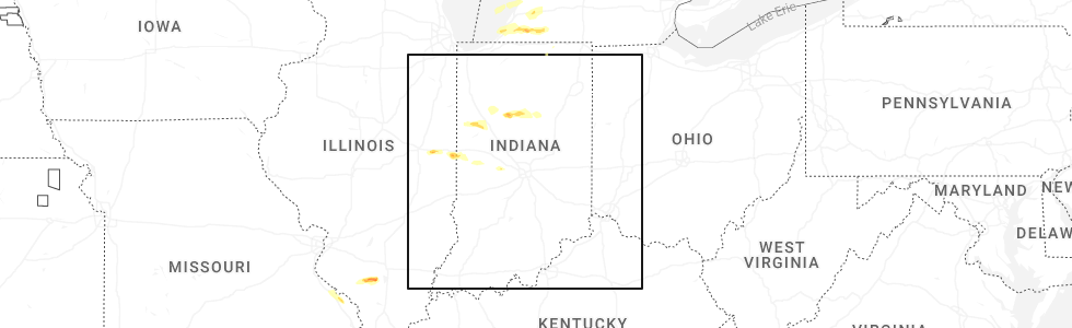
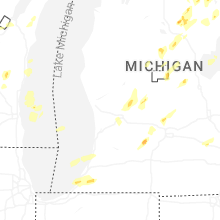
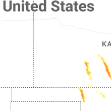
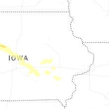
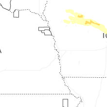
Hail Map for Tuesday, June 16, 2026
Number of Impacted Households on 6/16/2026
0
Impacted by 1" or Larger Hail
0
Impacted by 1.75" or Larger Hail
0
Impacted by 2.5" or Larger Hail
Square Miles of Populated Area Impacted on 6/16/2026
0
Impacted by 1" or Larger Hail
0
Impacted by 1.75" or Larger Hail
0
Impacted by 2.5" or Larger Hail
Cities Most Affected by Hail Storms of 6/16/2026
| Hail Size | Demographics of Zip Codes Affected | ||||||
|---|---|---|---|---|---|---|---|
| City | Count | Average | Largest | Pop Density | House Value | Income | Age |
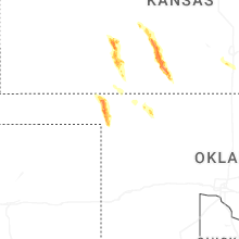
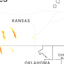
| Pratt, KS | 3 | 2.83 | 4.00 | 28 | $58k | $36.1k | 40.9 |
| Laverne, OK | 3 | 2.33 | 2.75 | 1 | $40k | $34.0k | 40.0 |
| Spearville, KS | 3 | 2.25 | 2.75 | 3 | $66k | $40.3k | 41.7 |
| Ford, KS | 2 | 2.13 | 2.50 | 2 | $32k | $35.2k | 40.9 |
| Dowagiac, MI | 2 | 2.00 | 2.00 | 132 | $82k | $37.0k | 40.2 |
| Vandalia, MI | 2 | 1.88 | 2.00 | 82 | $103k | $39.9k | 48.4 |
| Coats, KS | 1 | 1.75 | 1.75 | 1 | $17k | $33.4k | 37.5 |
| Ogden, IL | 1 | 1.75 | 1.75 | 20 | $88k | $47.2k | 39.9 |
| Rosston, OK | 1 | 1.75 | 1.75 | 1 | $33k | $37.9k | 55.3 |
| Covert, MI | 1 | 1.75 | 1.75 | 86 | $66k | $23.9k | 35.1 |
| Saint Joseph, IL | 1 | 1.75 | 1.75 | 78 | $107k | $55.1k | 37.2 |
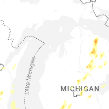
Hail and Wind Damage Spotted on 6/16/2026
Filter by Report Type:Hail ReportsWind Reports
States Impacted
Michigan, Wisconsin, Alabama, Florida, Illinois, Indiana, Missouri, North Dakota, Oklahoma, Kansas, Montana, IowaMichigan
| Local Time | Report Details |
|---|---|
| 1:00 PM EDT | Quarter sized hail reported near Milford, MI, 27.7 miles S of Flint, MI |
| 1:15 PM EDT | Quarter sized hail reported near Saint Helen, MI, 61.7 miles SW of Alpena, MI, time estimated by radar. |
| 1:50 PM EDT | Quarter sized hail reported near Luzerne, MI, 51.7 miles SW of Alpena, MI, time estimated by radar. |
| 1:58 PM EDT | Quarter sized hail reported near West Branch, MI, 59.4 miles SW of Alpena, MI, time estimated by radar. |
| 2:01 PM EDT | Quarter sized hail reported near Comins, MI, 34.7 miles WSW of Alpena, MI, caller reports quarter size hail covering the ground. |
| 2:01 PM EDT | Quarter sized hail reported near Saint Helen, MI, 68 miles ESE of Traverse City, MI, time estimates by radar. |
| 2:20 PM EDT | Quarter sized hail reported near Fairview, MI, 35.9 miles SW of Alpena, MI |
| 2:25 PM EDT | Quarter sized hail reported near Gladwin, MI, 71.4 miles SE of Traverse City, MI, time estimated by radar. |
| 2:30 PM EDT | Quarter sized hail reported near Glennie, MI, 40.9 miles SSW of Alpena, MI, time estimated by radar. |
| 2:51 PM EDT | Half Dollar sized hail reported near Atlanta, MI, 32.8 miles W of Alpena, MI |
| 2:58 PM EDT | Quarter sized hail reported near Rose City, MI, 57 miles SW of Alpena, MI |
| 3:23 PM EDT | Ping Pong Ball sized hail reported near Hawks, MI, 27.7 miles WNW of Alpena, MI |
| 4:08 PM EDT | Quarter sized hail reported near Rockford, MI, 15.1 miles NNE of Grand Rapids, MI, report from mping: quarter (1.00 in.). |
| 4:14 PM EDT | Quarter sized hail reported near Rockford, MI, 16.3 miles NNE of Grand Rapids, MI |
| 4:19 PM EDT | Quarter sized hail reported near Greenville, MI, 21.5 miles NE of Grand Rapids, MI |
| 4:50 PM EDT | Half Dollar sized hail reported near Nashville, MI, 38.9 miles SE of Grand Rapids, MI, two photos on social media taken 15 minutes after the storm passed. time based on radar. |
| 5:32 PM EDT | Quarter sized hail reported near Sheridan, MI, 29.6 miles NE of Grand Rapids, MI |
| 5:36 PM EDT | Quarter sized hail reported near Mount Pleasant, MI, 65.1 miles NW of Flint, MI, report from mping: quarter (1.00 in.). time estimated by radar. |
| 5:45 PM EDT | Hen Egg sized hail reported near Dowagiac, MI, 75.5 miles E of Chicago, IL |
| 6:06 PM EDT | Quarter sized hail reported near Bloomfield Hills, MI, 37.9 miles SSE of Flint, MI, photo report of 1 inch hail at the intersection of 15 & telegraph road. |
| 6:07 PM EDT | Quarter sized hail reported near Baroda, MI, 59.1 miles E of Chicago, IL, report from mping: quarter (1.00 in.). |
| 6:15 PM EDT | Golf Ball sized hail reported near Covert, MI, 54.7 miles SW of Grand Rapids, MI, two photos at van buren state park of at least golf ball size hail and possibly larger. |
| 6:19 PM EDT | Quarter sized hail reported near Berrien Springs, MI, 67.2 miles E of Chicago, IL, report from mping: quarter (1.00 in.). |
| 6:25 PM EDT | Half Dollar sized hail reported near South Haven, MI, 50.1 miles SW of Grand Rapids, MI |
| 6:30 PM EDT | Quarter sized hail reported near Berrien Center, MI, 69.3 miles E of Chicago, IL, jones and pokagon road. continued from 6:22 pm to 6:33 pm (quarter or less). |
| 6:35 PM EDT | Quarter sized hail reported near Berrien Springs, MI, 68.4 miles E of Chicago, IL, report from mping: quarter (1.00 in.). |
| 6:43 PM EDT | Quarter sized hail reported near Dowagiac, MI, 74.4 miles E of Chicago, IL |
| 6:45 PM EDT | Hen Egg sized hail reported near Dowagiac, MI, 75.5 miles E of Chicago, IL, corrects previous hail report from 1 nne pokagon. |
| 6:47 PM EDT | Half Dollar sized hail reported near Dowagiac, MI, 75.5 miles E of Chicago, IL, report from mping: half dollar (1.25 in.). |
| 6:59 PM EDT | Quarter sized hail reported near Cassopolis, MI, 75 miles NW of Fort Wayne, IN, report from mping: quarter (1.00 in.). |
| 7:00 PM EDT | Quarter sized hail reported near Cassopolis, MI, 70.3 miles SSW of Grand Rapids, MI, varying smaller sizes... the largest up to quarter sized. time between 7pm-7:03pm et. |
| 7:05 PM EDT | Golf Ball sized hail reported near Vandalia, MI, 72.2 miles NW of Fort Wayne, IN |
| 7:09 PM EDT | Half Dollar sized hail reported near Vandalia, MI, 71.9 miles NW of Fort Wayne, IN, report from mping: half dollar (1.25 in.). |
| 7:12 PM EDT | Hen Egg sized hail reported near Vandalia, MI, 72.1 miles NW of Fort Wayne, IN, 2.17 inch measured hail stone measured with photo. also observed ping pong to golf ball sized hail. |
| 8:33 PM EDT | Quarter sized hail reported near Ionia, MI, 30.5 miles E of Grand Rapids, MI, report from mping: quarter (1.00 in.). |
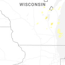
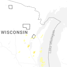
Wisconsin
| Local Time | Report Details |
|---|---|
| 1:22 PM CDT | Quarter sized hail reported near Oshkosh, WI, 44.6 miles SW of Green Bay, WI |
| 2:00 PM CDT | Quarter sized hail reported near Cascade, WI, 56.6 miles S of Green Bay, WI, quarter sized hail at camp long lake. |
| 2:20 PM CDT | Quarter sized hail reported near , , 41 miles SW of Green Bay, WI |
Alabama
| Local Time | Report Details |
|---|---|
| 1:27 PM CDT | Weatherflow station xglf gulf shores measured a wind gust of 67 mp in baldwin county AL, 32.9 miles SE of Mobile, AL |
Florida
| Local Time | Report Details |
|---|---|
| 2:50 PM CDT | Possible utility line down near caldwell driv in bay county FL, 44.8 miles ESE of Miramar Beach, FL |
| 2:51 PM CDT | Report of a large tree down near east 8th street and bay avenu in bay county FL, 45.6 miles ESE of Miramar Beach, FL |
| 2:53 PM CDT | Corrects previous tstm wnd dmg report from 1 w dirego park. power line down on east 23rd stree in bay county FL, 44.4 miles ESE of Miramar Beach, FL |
| 3:03 PM CDT | Corrects previous tstm wnd dmg report from 3 nne vicksburg. tree down on power line on highway 38 in bay county FL, 43.1 miles E of Miramar Beach, FL |
| 3:11 PM CDT | Tree down on power line on highway 38 in bay county FL, 43.1 miles E of Miramar Beach, FL |
| 3:21 PM CDT | Power line down on east 23rd stree in bay county FL, 44.4 miles ESE of Miramar Beach, FL |
| 4:30 PM EDT | An object blew into power lines and resulted in a power outag in franklin county FL, 42.2 miles SSW of Tallahassee, FL |
| 3:40 PM CDT | Possible downed tree on a curve near the west side of the creek on john f bailey roa in calhoun county FL, 49.5 miles W of Tallahassee, FL |
| 4:45 PM EDT | Power line down on robertson mill roa in liberty county FL, 40.6 miles W of Tallahassee, FL |
| 3:46 PM CDT | Tree down on power line along dan parrish roa in calhoun county FL, 45.4 miles W of Tallahassee, FL |
| 3:52 PM CDT | Video posted on social media shows damage to a shed and trees dow in calhoun county FL, 50.3 miles W of Tallahassee, FL |
| 4:55 PM EDT | Power line down along highway 12 nort in liberty county FL, 36 miles W of Tallahassee, FL |
| 4:00 PM CDT | Fhp reports possible tree down in the area of damascus loop and kynesville roa in jackson county FL, 63.8 miles WNW of Tallahassee, FL |
| 5:07 PM EDT | Trees down in crawfordvill in wakulla county FL, 18.7 miles SSW of Tallahassee, FL |
| 5:10 PM EDT | Trained spotter measured a 61 mph wind gust with tempest weather statio in wakulla county FL, 15.9 miles SSW of Tallahassee, FL |
| 5:19 PM EDT | Trained spotter measured a 63 mph wind gus in wakulla county FL, 18.5 miles SSW of Tallahassee, FL |
| 5:43 PM EDT | Tree down near iron bridge road and concord roa in gadsden county FL, 12.3 miles NNW of Tallahassee, FL |
| 5:45 PM EDT | Fhp reports a tree in the roadway on capps hwy at st augustine r in jefferson county FL, 14.6 miles E of Tallahassee, FL |
| 5:50 PM EDT | Tree down near miccosukee road and argyle lan in leon county FL, 9.7 miles ENE of Tallahassee, FL |
| 5:53 PM EDT | Fhp reports a tree down in the right lane of i-10 westbound near mile marker 22 in jefferson county FL, 19.9 miles E of Tallahassee, FL |
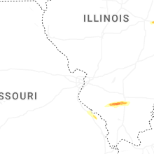
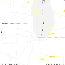
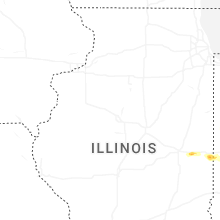
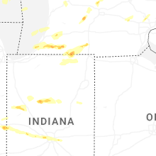
Illinois
| Local Time | Report Details |
|---|---|
| 3:47 PM CDT | Half Dollar sized hail reported near Saint Joseph, IL, 46.9 miles NNE of Mattoon, IL, report from mping: half dollar (1.25 in.). |
| 3:47 PM CDT | Golf Ball sized hail reported near Saint Joseph, IL, 46.9 miles NNE of Mattoon, IL, golf ball size hail with photo by measuring tape. |
| 3:51 PM CDT | Ping Pong Ball sized hail reported near Saint Joseph, IL, 47.8 miles NNE of Mattoon, IL, ping pong size hail along i-74 west of odgen. a few pieces of hail larger than ping pong. |
| 3:52 PM CDT | Golf Ball sized hail reported near Ogden, IL, 48.7 miles NNE of Mattoon, IL, oblong shape golf ball size hail from a viewer with photo. |
| 4:03 PM CDT | Ping Pong Ball sized hail reported near Bismarck, IL, 67.4 miles NE of Mattoon, IL, photo of two large hailstones in hand. |
| 4:25 PM CDT | Quarter sized hail reported near Westville, IL, 55.9 miles NE of Mattoon, IL, quarter size hail in belgium. |
| 6:19 PM CDT | A couple trees downed and a power pole snappe in perry county IL, 54.9 miles N of Cape Girardeau, MO |
| 6:20 PM CDT | Multiple large tree branches downed near south lake roa in perry county IL, 55.6 miles N of Cape Girardeau, MO |
| 6:21 PM CDT | Quarter sized hail reported near Pinckneyville, IL, 54.5 miles N of Cape Girardeau, MO |
| 6:33 PM CDT | Half Dollar sized hail reported near Tamaroa, IL, 57.5 miles NNE of Cape Girardeau, MO |
| 6:33 PM CDT | Powerline down across a road in tamaro in perry county IL, 59.6 miles NNE of Cape Girardeau, MO |
| 6:46 PM CDT | Quarter sized hail reported near Sesser, IL, 61.3 miles NNE of Cape Girardeau, MO, quarter size hail north of sesser; winds gusted to 50mph. |
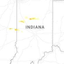
Indiana
| Local Time | Report Details |
|---|---|
| 5:12 PM EDT | Half Dollar sized hail reported near Flora, IN, 57.9 miles NNW of Indianapolis, IN |
| 5:21 PM EDT | Half Dollar sized hail reported near Oxford, IN, 76.5 miles NW of Indianapolis, IN |
| 5:31 PM EDT | Half Dollar sized hail reported near Delphi, IN, 65.8 miles NNW of Indianapolis, IN, report from mping: half dollar (1.25 in.). |
| 5:35 PM EDT | Quarter sized hail reported near West Lafayette, IN, 69.7 miles NW of Indianapolis, IN |
| 5:48 PM EDT | 1.5 ft diameter tree snapped at the base. appears mostly health in cass county IN, 61.4 miles N of Indianapolis, IN |
| 5:50 PM EDT | Quarter sized hail reported near Walton, IN, 61.8 miles N of Indianapolis, IN |
| 5:58 PM EDT | Some structural damage to a shed... a downed pine tree... and some siding damage. pending further details from em in cass county IN, 61.8 miles N of Indianapolis, IN |
| 6:23 PM EDT | Three trees downed by thunderstorm wind gust in parke county IN, 58.1 miles WNW of Indianapolis, IN |
| 6:25 PM EDT | Thunderstorm wind gusts downed several tree in parke county IN, 58.1 miles W of Indianapolis, IN |
| 6:55 PM EDT | Quarter sized hail reported near Roachdale, IN, 39.9 miles W of Indianapolis, IN |
| 6:58 PM EDT | Rough wind estimat in montgomery county IN, 32.7 miles WNW of Indianapolis, IN |
| 7:02 PM EDT | Storm damage reported in putnam county IN, 34.5 miles W of Indianapolis, IN |
| 7:18 PM EDT | Half Dollar sized hail reported near Goshen, IN, 50.2 miles NW of Fort Wayne, IN, report from mping: half dollar (1.25 in.). |
| 7:31 PM EDT | Quarter sized hail reported near Shipshewana, IN, 49.2 miles NNW of Fort Wayne, IN |
| 7:37 PM EDT | Quarter sized hail reported near Poneto, IN, 32.5 miles SSW of Fort Wayne, IN |
| 7:51 PM EDT | Quarter sized hail reported near Brownsburg, IN, 11.9 miles W of Indianapolis, IN |
| 7:57 PM EDT | Quarter sized hail reported near Indianapolis, IN, 9.2 miles W of Indianapolis, IN |
| 7:58 PM EDT | Quarter sized hail reported near Shipshewana, IN, 48 miles NNW of Fort Wayne, IN |
| 8:04 PM EDT | Half Dollar sized hail reported near Indianapolis, IN, 4.2 miles WSW of Indianapolis, IN |
| 8:33 PM EDT | Half Dollar sized hail reported near New Palestine, IN, 13.9 miles E of Indianapolis, IN, quarter to half dollar size hail is falling. |
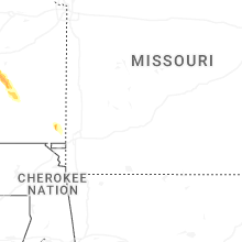
Missouri
| Local Time | Report Details |
|---|---|
| 6:05 PM CDT | Quarter sized hail reported near Perryville, MO, 38.9 miles NNW of Cape Girardeau, MO |
| 6:08 PM CDT | Quarter sized hail reported near Perryville, MO, 37.4 miles NNW of Cape Girardeau, MO |
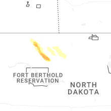
North Dakota
| Local Time | Report Details |
|---|---|
| 6:16 PM CDT | Corrects previous non-tstm wnd gst report from 1 e minot air force base. awos station kmib minot af in ward county ND, 12.8 miles N of Minot, ND |
| 7:19 PM MDT | 10 meter wind sensor at marmarth ndawn statio in slope county ND, 91.5 miles E of Miles City, MT |
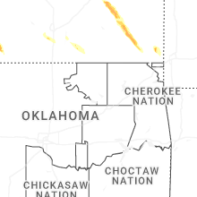
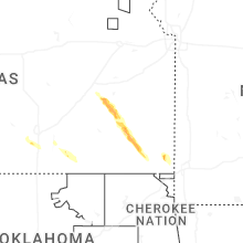
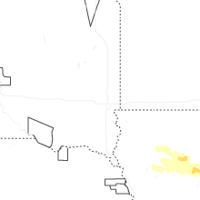
Oklahoma
| Local Time | Report Details |
|---|---|
| 6:30 PM CDT | Quarter sized hail reported near Gate, OK, 46.6 miles NW of Woodward, OK, report of quarter size hail in gate. |
| 6:52 PM CDT | Golf Ball sized hail reported near Rosston, OK, 42.3 miles NW of Woodward, OK, approximate location. |
| 7:20 PM CDT | Golf Ball sized hail reported near Laverne, OK, 35.1 miles WNW of Woodward, OK |
| 7:23 PM CDT | Tennis Ball sized hail reported near Laverne, OK, 36.1 miles WNW of Woodward, OK |
| 7:25 PM CDT | Baseball sized hail reported near Laverne, OK, 36.1 miles WNW of Woodward, OK, corrects previous hail report from 3 w laverne. |
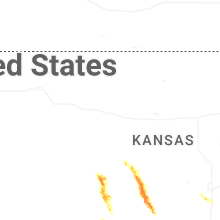
Kansas
| Local Time | Report Details |
|---|---|
| 6:42 PM CDT | Ping Pong Ball sized hail reported near Spearville, KS, 58.8 miles E of Garden City, KS |
| 6:45 PM CDT | Hen Egg sized hail reported near Spearville, KS, 61.9 miles E of Garden City, KS, report received through social media with pictures. |
| 6:45 PM CDT | Hen Egg sized hail reported near Spearville, KS, 59.1 miles E of Garden City, KS, report received through social media with pictures. |
| 6:45 PM CDT | Half Dollar sized hail reported near Garfield, KS, 54.8 miles S of Hays, KS, delayed report. public picture on social media showed hail ranging from penny to half-dollar size in the town of garfield. |
| 6:45 PM CDT | Baseball sized hail reported near Spearville, KS, 59.1 miles E of Garden City, KS, delayed report. pictures via social media reported golf balls to a few baseball size. |
| 7:45 PM CDT | Tennis Ball sized hail reported near Ford, KS, 64.8 miles ESE of Garden City, KS, delayed reported. report of a mix of ping pong ball to tennis ball sized hail with video via social media. |
| 7:48 PM CDT | Golf Ball sized hail reported near Ford, KS, 65.5 miles ESE of Garden City, KS |
| 8:22 PM CDT | Grapefruit sized hail reported near Pratt, KS, 85.9 miles W of Wichita, KS |
| 8:26 PM CDT | Ping Pong Ball sized hail reported near Pratt, KS, 81.9 miles SSE of Hays, KS |
| 8:37 PM CDT | Baseball sized hail reported near Pratt, KS, 81.1 miles W of Wichita, KS |
| 8:40 PM CDT | Golf Ball sized hail reported near Pratt, KS, 82 miles W of Wichita, KS |
| 8:56 PM CDT | Golf Ball sized hail reported near Coats, KS, 80.8 miles NNE of Woodward, OK |
| 9:06 PM CDT | Ping Pong Ball sized hail reported near Ashland, KS, 61.2 miles NNW of Woodward, OK |
| 9:06 PM CDT | Ping Pong Ball sized hail reported near Ashland, KS, 59.7 miles N of Woodward, OK, corrects location of previous hail report from 9 n sitka to 8 nw protection. |
| 11:18 PM CDT | Quarter sized hail reported near Yates Center, KS, 26.4 miles NW of Chanute, KS |
Montana
| Local Time | Report Details |
|---|---|
| 5:53 PM MDT | Asos station khvr havre airpor in hill county MT, 4.5 miles W of Havre, MT |
| 6:45 PM MDT | Sand springs mesonet observation (sdsm8 in garfield county MT, 84.9 miles SSW of Glasgow, MT |
| 8:30 PM MDT | Mesonet station mtbch beacon hill us-87 mp 35. in fergus county MT, 77.9 miles N of Billings, MT |
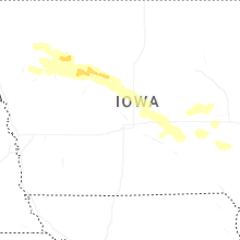
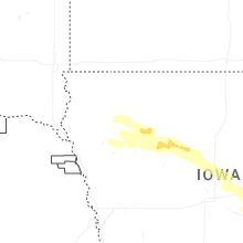
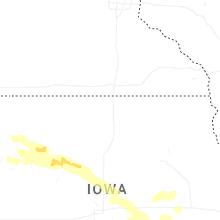
Iowa
| Local Time | Report Details |
|---|---|
| 3:32 AM CDT | Mesonet station rsli4 storm lak in buena vista county IA, 7.5 miles NNE of Storm Lake, IA |
| 4:25 AM CDT | Pws gus in calhoun county IA, 31.8 miles ESE of Storm Lake, IA |
| 4:30 AM CDT | Two semis blown over on us-2 in calhoun county IA, 26.8 miles ESE of Storm Lake, IA |
| 4:45 AM CDT | Pws gus in webster county IA, 58.2 miles E of Storm Lake, IA |
| 4:49 AM CDT | Storm damage reported in hamilton county IA, 59.5 miles SW of Mason City, IA |
| 4:55 AM CDT | Storm damage reported in hamilton county IA, 59.5 miles SW of Mason City, IA |
| 5:02 AM CDT | Pws gus in hamilton county IA, 52.7 miles N of Des Moines, IA |
| 5:22 AM CDT | Pws gus in hardin county IA, 47.7 miles NNE of Des Moines, IA |
| 5:28 AM CDT | Pws gus in marshall county IA, 45.2 miles NNE of Des Moines, IA |
| 5:29 AM CDT | Pws gus in story county IA, 33.8 miles N of Des Moines, IA |
| 5:45 AM CDT | Storm damage reported in marshall county IA, 50.8 miles NE of Des Moines, IA |
| 5:46 AM CDT | Trees blocking roads in conrad. time estimated via rada in grundy county IA, 58.1 miles NE of Des Moines, IA |
| 5:47 AM CDT | Storm damage reported in grundy county IA, 58.1 miles NE of Des Moines, IA |
| 5:57 AM CDT | Multiple trees uproote in marshall county IA, 49.6 miles NE of Des Moines, IA |
| 6:11 AM CDT | Pws gus in tama county IA, 49.2 miles W of Cedar Rapids, IA |
| 6:33 AM CDT | Storm damage reported in iowa county IA, 31.2 miles WSW of Cedar Rapids, IA |
| 6:38 AM CDT | Storm damage reported in benton county IA, 21.4 miles WSW of Cedar Rapids, IA |
| 6:38 AM CDT | Storm damage reported in benton county IA, 19.9 miles W of Cedar Rapids, IA |
Connect with Interactive Hail Maps