

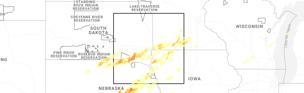
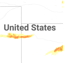
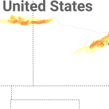
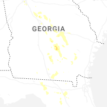
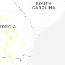
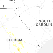
Hail Map for Sunday, May 17, 2026
Number of Impacted Households on 5/17/2026
0
Impacted by 1" or Larger Hail
0
Impacted by 1.75" or Larger Hail
0
Impacted by 2.5" or Larger Hail
Square Miles of Populated Area Impacted on 5/17/2026
0
Impacted by 1" or Larger Hail
0
Impacted by 1.75" or Larger Hail
0
Impacted by 2.5" or Larger Hail
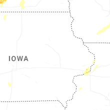
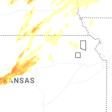
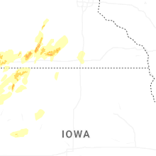
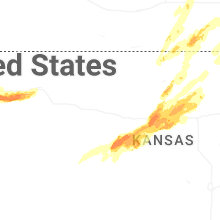

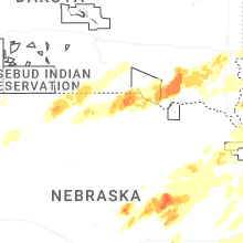

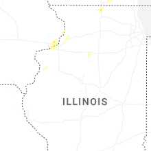
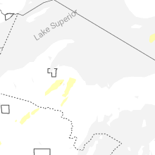
Cities Most Affected by Hail Storms of 5/17/2026
| Hail Size | Demographics of Zip Codes Affected | ||||||
|---|---|---|---|---|---|---|---|
| City | Count | Average | Largest | Pop Density | House Value | Income | Age |
| Dannebrog, NE | 6 | 2.67 | 3.00 | 12 | $52k | $37.4k | 43.2 |
| Ashton, NE | 5 | 2.35 | 3.00 | 2 | $31k | $31.1k | 47.6 |
| Deshler, NE | 2 | 2.25 | 2.50 | 5 | $33k | $30.7k | 46.7 |
| Ruth, MI | 2 | 2.13 | 2.50 | 18 | $64k | $36.5k | 40.4 |
| Tescott, KS | 2 | 1.88 | 2.00 | 6 | $48k | $41.6k | 43.4 |
| Dorrance, KS | 2 | 1.75 | 1.75 | 1 | $16k | $31.5k | 51.3 |
| Guide Rock, NE | 2 | 1.75 | 1.75 | 2 | $23k | $24.1k | 49.3 |
| Palmer, NE | 1 | 3.50 | 3.50 | 4 | $50k | $32.6k | 44.6 |
| Elba, NE | 1 | 2.75 | 2.75 | 3 | $73k | $33.8k | 43.9 |
| Saint Paul, NE | 1 | 2.50 | 2.50 | 18 | $69k | $33.0k | 42.3 |
| Unionville, MI | 1 | 2.00 | 2.00 | 28 | $76k | $39.2k | 42.5 |
| Russell, KS | 1 | 2.00 | 2.00 | 15 | $46k | $30.2k | 45.3 |
| Nekoma, KS | 1 | 2.00 | 2.00 | 1 | $13k | $25.8k | 51.0 |
| Wisner, NE | 1 | 1.75 | 1.75 | 8 | $55k | $33.5k | 42.9 |
| Cairo, NE | 1 | 1.75 | 1.75 | 6 | $69k | $36.3k | 38.6 |
| Menno, SD | 1 | 1.75 | 1.75 | 5 | $31k | $29.3k | 53.7 |
| Wilson, KS | 1 | 1.75 | 1.75 | 3 | $40k | $37.7k | 49.6 |
| Rush Center, KS | 1 | 1.75 | 1.75 | 3 | $31k | $31.9k | 50.1 |
| Fullerton, NE | 1 | 1.75 | 1.75 | 5 | $44k | $30.6k | 46.9 |
| Superior, NE | 1 | 1.75 | 1.75 | 16 | $36k | $26.9k | 51.0 |
| Minneapolis, KS | 1 | 1.75 | 1.75 | 11 | $64k | $35.5k | 41.7 |
| Lismore, MN | 1 | 1.75 | 1.75 | 6 | $32k | $27.7k | 43.6 |
| Boelus, NE | 1 | 1.75 | 1.75 | 7 | $46k | $27.3k | 48.0 |
| Le Mars, IA | 1 | 1.75 | 1.75 | 51 | $92k | $40.3k | 39.4 |
| Sanborn, IA | 1 | 1.75 | 1.75 | 14 | $64k | $37.8k | 44.7 |
| Hunter, KS | 1 | 1.75 | 1.75 | 1 | $15k | $25.6k | 54.8 |
Hail and Wind Damage Spotted on 5/17/2026
Filter by Report Type:Hail ReportsWind Reports
States Impacted
South Dakota, Nebraska, Wisconsin, Colorado, Georgia, Florida, Michigan, Kansas, Iowa, Minnesota, Mississippi, MissouriSouth Dakota
| Local Time | Report Details |
|---|---|
| 1:40 PM CDT | Half Dollar sized hail reported near Burke, SD, 59.6 miles NNW of Oneill, NE, in addtion to half dollar sized hail... heavy rain is falling. |
| 1:45 PM CDT | Via personal weather station. exact time estimated via rada in gregory county SD, 55.9 miles NNW of Oneill, NE |
| 1:56 PM CDT | Via personal weather station. exact time estimated via rada in gregory county SD, 44.6 miles NNW of Oneill, NE |
| 2:07 PM CDT | Via personal weather station. exact time estimated via rada in charles mix county SD, 56.9 miles N of Oneill, NE |
| 2:30 PM CDT | Mesonet station 244 sd rwis ft. randall da in gregory county SD, 41.1 miles N of Oneill, NE |
| 2:34 PM CDT | Via personal weather station. exact time estimated via rada in charles mix county SD, 50.8 miles N of Oneill, NE |
| 2:37 PM CDT | Quarter sized hail reported near Wagner, SD, 38 miles NNE of Oneill, NE, winds estimated 40-50 mph. |
| 2:40 PM CDT | Full trees down along with older farm outbuildings collapsed. time estimated via rada in charles mix county SD, 45.3 miles NNE of Oneill, NE |
| 2:40 PM CDT | Via personal weather station. exact time estimated via rada in charles mix county SD, 45.6 miles NNE of Oneill, NE |
| 2:44 PM CDT | A mile of power lines down near the intersection of 298th st and 393rd ave. time estimated from rada in charles mix county SD, 45.3 miles NNE of Oneill, NE |
| 2:46 PM CDT | Heavily damaged outbuilding. time estimated from rada in charles mix county SD, 47.7 miles NNE of Oneill, NE |
| 2:46 PM CDT | Wind gusts 50-60 mph broke down 1.5 to 2 inch tree branches. sheets of heavy rain and pea hail were also fallin in charles mix county SD, 45.3 miles NNE of Oneill, NE |
| 2:48 PM CDT | Awos station kagz wagne in charles mix county SD, 45.8 miles NNE of Oneill, NE |
| 2:48 PM CDT | Broken power poles. time estimated from rada in charles mix county SD, 49.5 miles NNE of Oneill, NE |
| 2:50 PM CDT | Mesonet station 304 sd rwis corsic in douglas county SD, 64.8 miles N of Oneill, NE |
| 2:50 PM CDT | Mobile trailer flipped... dismantled... and moved about 60 ft. pickup truck tipped on its side. time estimated from rada in charles mix county SD, 48.9 miles NNE of Oneill, NE |
| 2:52 PM CDT | Mesonet station 324 sd rwis wagne in charles mix county SD, 50.4 miles NNE of Oneill, NE |
| 2:53 PM CDT | Photo of blown in grain bins via em. time estimated via rada in aurora county SD, 77.5 miles N of Oneill, NE |
| 2:54 PM CDT | Trained spotter reported a shed with its roof blown of in bon homme county SD, 47.3 miles NE of Oneill, NE |
| 2:58 PM CDT | Mesonet station avms2 avon 3e (sd mesonet in bon homme county SD, 50.4 miles NE of Oneill, NE |
| 3:00 PM CDT | Via personal weather station. exact time estimated via rada in bon homme county SD, 50.9 miles NE of Oneill, NE |
| 3:05 PM CDT | Farm out-buildings severely damaged and 5th wheel camper overturne in bon homme county SD, 59.5 miles NE of Oneill, NE |
| 3:15 PM CDT | 65 to 70 mph downed small trees. quarter sized hail also occurre in bon homme county SD, 53 miles NE of Oneill, NE |
| 3:16 PM CDT | Via personal weather statio in bon homme county SD, 58.2 miles WSW of Sioux Falls, SD |
| 3:24 PM CDT | Asos station kmhe mitchell municipal airpor in davison county SD, 67.4 miles WNW of Sioux Falls, SD |
| 3:36 PM CDT | Quarter sized hail reported near Menno, SD, 45.2 miles WSW of Sioux Falls, SD, corrects time of previous hail report from 3 e menno. via mping. time estimated via radar. |
| 3:36 PM CDT | Golf Ball sized hail reported near Menno, SD, 44.6 miles WSW of Sioux Falls, SD, photo of roughly golf ball size hail. time estimated via radar. |
| 3:37 PM CDT | Large garage door on outbuilding bowed in. time estimated from rada in hutchinson county SD, 41.9 miles WSW of Sioux Falls, SD |
| 3:38 PM CDT | Mesonet station mnms2 menno 7ese (sd mesonet in hutchinson county SD, 43 miles WSW of Sioux Falls, SD |
| 3:42 PM CDT | Mesonet station 163 sd rwis freema in hutchinson county SD, 39.2 miles WSW of Sioux Falls, SD |
| 3:42 PM CDT | Damage to large road signs near intersection of hwy 18/8 in hutchinson county SD, 40.6 miles WSW of Sioux Falls, SD |
| 3:44 PM CDT | Quarter sized hail reported near Menno, SD, 45.2 miles WSW of Sioux Falls, SD, via mping. time estimated via radar. |
| 3:44 PM CDT | Quarter sized hail reported near Viborg, SD, 39.7 miles SW of Sioux Falls, SD, via mping. time estimated via radar. |
| 3:47 PM CDT | Spotter estimated 50-60 mph winds along with half dollar size hai in turner county SD, 33.5 miles SW of Sioux Falls, SD |
| 4:09 PM CDT | Power poles snapped and irrigation pivots flipped near the intersection of 276th st and 456th ave. time estimated from rada in turner county SD, 20.6 miles WSW of Sioux Falls, SD |
| 4:14 PM CDT | Via personal weather station. exact time estimated via rada in turner county SD, 18.2 miles SW of Sioux Falls, SD |
| 4:15 PM CDT | 70 mph caused downed tree branche in turner county SD, 16.9 miles SW of Sioux Falls, SD |
| 4:17 PM CDT | Via personal weather station. exact time estimated via rada in turner county SD, 15 miles SW of Sioux Falls, SD |
| 4:17 PM CDT | Quarter sized hail reported near Lennox, SD, 16.8 miles SW of Sioux Falls, SD, quarter size hail along with estimated 40-50 mph winds reported. |
| 4:32 PM CDT | Quarter sized hail reported near Sioux Falls, SD, 5.6 miles W of Sioux Falls, SD, report from mping. |
| 4:36 PM CDT | Quarter sized hail reported near Sioux Falls, SD, 4.6 miles SSW of Sioux Falls, SD, report from 85th and western of quarter size hail. |
| 4:38 PM CDT | Quarter sized hail reported near Tea, SD, 8.6 miles SW of Sioux Falls, SD |
| 4:47 PM CDT | Ping Pong Ball sized hail reported near Sioux Falls, SD, 4 miles SSE of Sioux Falls, SD |
| 5:02 PM CDT | Quarter sized hail reported near Valley Springs, SD, 14 miles ENE of Sioux Falls, SD |
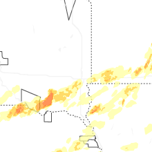
Nebraska
| Local Time | Report Details |
|---|---|
| 2:08 PM CDT | Storm damage reported in boyd county NE, 26.8 miles N of Oneill, NE |
| 2:15 PM CDT | Storm damage reported in boyd county NE, 27.1 miles N of Oneill, NE |
| 2:15 PM CDT | Roof partially blowm off a gas station. several large tree branches dow in boyd county NE, 28.6 miles N of Oneill, NE |
| 4:14 PM CDT | Quarter sized hail reported near Ravenna, NE, 28.2 miles W of Grand Island, NE |
| 4:30 PM CDT | Tennis Ball sized hail reported near Ashton, NE, 32.5 miles NW of Grand Island, NE |
| 4:34 PM CDT | Golf Ball sized hail reported near Boelus, NE, 22.3 miles WNW of Grand Island, NE |
| 4:35 PM CDT | Golf Ball sized hail reported near Ashton, NE, 34.4 miles NW of Grand Island, NE |
| 4:43 PM CDT | Tea Cup sized hail reported near Ashton, NE, 32.5 miles NW of Grand Island, NE |
| 4:44 PM CDT | Golf Ball sized hail reported near Dannebrog, NE, 17.4 miles NW of Grand Island, NE |
| 4:50 PM CDT | Hen Egg sized hail reported near Ashton, NE, 31.2 miles NW of Grand Island, NE |
| 4:51 PM CDT | Tennis Ball sized hail reported near Ashton, NE, 32.5 miles NW of Grand Island, NE, danny near ashton. |
| 4:52 PM CDT | Golf Ball sized hail reported near Cairo, NE, 15.2 miles NW of Grand Island, NE, report from mping: golf ball (1.75 in.). |
| 4:54 PM CDT | Baseball sized hail reported near Elba, NE, 27.9 miles NNW of Grand Island, NE |
| 4:56 PM CDT | Quarter sized hail reported near Elba, NE, 28.5 miles NNW of Grand Island, NE |
| 4:58 PM CDT | Baseball sized hail reported near Dannebrog, NE, 17.4 miles NW of Grand Island, NE, corrects previous hail report from dannebrog. |
| 4:58 PM CDT | Tea Cup sized hail reported near Dannebrog, NE, 17.3 miles NW of Grand Island, NE, corrects previous hail report from 1 ne dannebrog. |
| 5:04 PM CDT | Baseball sized hail reported near Dannebrog, NE, 17.4 miles NW of Grand Island, NE |
| 5:11 PM CDT | Baseball sized hail reported near Dannebrog, NE, 17.4 miles NW of Grand Island, NE |
| 5:14 PM CDT | Ping Pong Ball sized hail reported near Saint Paul, NE, 20.7 miles NNW of Grand Island, NE |
| 5:15 PM CDT | Tennis Ball sized hail reported near Saint Paul, NE, 18.3 miles N of Grand Island, NE |
| 5:17 PM CDT | Storm damage reported in fillmore county NE, 46.5 miles ESE of Grand Island, NE |
| 5:18 PM CDT | Storm damage reported in howard county NE, 21.8 miles N of Grand Island, NE |
| 5:25 PM CDT | Tea Cup sized hail reported near Palmer, NE, 20.9 miles NNE of Grand Island, NE |
| 5:27 PM CDT | Golf Ball sized hail reported near Guide Rock, NE, 57.6 miles S of Grand Island, NE |
| 5:27 PM CDT | Tea Cup sized hail reported near Dannebrog, NE, 17.3 miles NW of Grand Island, NE |
| 5:30 PM CDT | Storm damage reported in nuckolls county NE, 52.8 miles SSE of Grand Island, NE |
| 5:32 PM CDT | Corrects previous tstm wnd gst report from 5 n palme in nance county NE, 26.9 miles NNE of Grand Island, NE |
| 5:35 PM CDT | Storm damage reported in nuckolls county NE, 49.7 miles SSE of Grand Island, NE |
| 5:36 PM CDT | Golf Ball sized hail reported near Guide Rock, NE, 63.5 miles S of Grand Island, NE |
| 5:39 PM CDT | Storm damage reported in nance county NE, 26.9 miles NNE of Grand Island, NE |
| 5:40 PM CDT | Golf Ball sized hail reported near Superior, NE, 62.7 miles SSE of Grand Island, NE |
| 5:43 PM CDT | Ping Pong Ball sized hail reported near Deweese, NE, 41.7 miles SSE of Grand Island, NE |
| 5:43 PM CDT | Ping Pong Ball sized hail reported near Deweese, NE, 44 miles SSE of Grand Island, NE |
| 5:47 PM CDT | Pea to dime sized hail... 50-60 mph wind in clay county NE, 31.8 miles SSE of Grand Island, NE |
| 5:52 PM CDT | Storm damage reported in nance county NE, 45.5 miles NNE of Grand Island, NE |
| 6:00 PM CDT | Golf Ball sized hail reported near Fullerton, NE, 35.4 miles NNE of Grand Island, NE |
| 6:00 PM CDT | Storm damage reported in merrick county NE, 19.8 miles NE of Grand Island, NE |
| 6:01 PM CDT | Storm damage reported in nance county NE, 50.3 miles NE of Grand Island, NE |
| 6:05 PM CDT | Personal weather statio in madison county NE, 64.1 miles SE of Oneill, NE |
| 6:06 PM CDT | Ping Pong Ball sized hail reported near Henderson, NE, 28.4 miles ESE of Grand Island, NE |
| 6:08 PM CDT | Storm damage reported in fillmore county NE, 49.9 miles SE of Grand Island, NE |
| 6:08 PM CDT | Powerlines dow in nance county NE, 35.4 miles NNE of Grand Island, NE |
| 6:10 PM CDT | Quarter sized hail reported near Byron, NE, 69.9 miles SSE of Grand Island, NE |
| 6:12 PM CDT | Reports of downed power line in nance county NE, 48.2 miles NE of Grand Island, NE |
| 6:14 PM CDT | Nebraska mesone in platte county NE, 50.6 miles NE of Grand Island, NE |
| 6:15 PM CDT | Storm damage reported in fillmore county NE, 48.4 miles ESE of Grand Island, NE |
| 6:15 PM CDT | Ping Pong Ball sized hail reported near Central City, NE, 23.5 miles NE of Grand Island, NE, report from mping: ping pong ball (1.50 in.). |
| 6:19 PM CDT | Quarter sized hail reported near Central City, NE, 22.3 miles NE of Grand Island, NE |
| 6:20 PM CDT | Personal weather statio in platte county NE, 63.4 miles NE of Grand Island, NE |
| 6:25 PM CDT | Storm damage reported in nance county NE, 45.5 miles NNE of Grand Island, NE |
| 6:29 PM CDT | Public weather statio in platte county NE, 71.4 miles NE of Grand Island, NE |
| 6:30 PM CDT | Hen Egg sized hail reported near Deshler, NE, 63.2 miles SSE of Grand Island, NE, image sent in of 2 hail. |
| 6:33 PM CDT | Quarter sized hail reported near Clarks, NE, 33.1 miles NE of Grand Island, NE |
| 6:33 PM CDT | Storm damage reported in thayer county NE, 56.9 miles SE of Grand Island, NE |
| 6:34 PM CDT | Tennis Ball sized hail reported near Deshler, NE, 62.9 miles SSE of Grand Island, NE |
| 6:35 PM CDT | Large tree down in frien in saline county NE, 58.7 miles ESE of Grand Island, NE |
| 6:36 PM CDT | Quarter sized hail reported near Humphrey, NE, 71.3 miles NE of Grand Island, NE, corrects previous hail report from clarkson. |
| 6:36 PM CDT | Quarter sized hail reported near Clarkson, NE, 68.9 miles WNW of Omaha, NE |
| 6:37 PM CDT | Public weather statio in platte county NE, 76 miles NE of Grand Island, NE |
| 6:57 PM CDT | Quarter sized hail reported near Wisner, NE, 71.1 miles NW of Omaha, NE |
| 6:59 PM CDT | Golf Ball sized hail reported near Wisner, NE, 70.8 miles NW of Omaha, NE |
| 7:02 PM CDT | Quarter sized hail reported near Davenport, NE, 56 miles SSE of Grand Island, NE, had many reports of 3/4 inch mixed in with the inch hail. |
| 7:07 PM CDT | Storm damage reported in fillmore county NE, 55.4 miles SE of Grand Island, NE |
| 7:09 PM CDT | Power is out in bancrof in cuming county NE, 61.1 miles NNW of Omaha, NE |
| 7:10 PM CDT | Report on social media of a tree knocked over tre in thayer county NE, 59.5 miles SE of Grand Island, NE |
| 7:14 PM CDT | Upr statio in dodge county NE, 46.8 miles WNW of Omaha, NE |
| 7:15 PM CDT | Personal weather statio in cuming county NE, 53.9 miles NW of Omaha, NE |
| 7:16 PM CDT | Quarter sized hail reported near Pender, NE, 70.9 miles NW of Omaha, NE |
| 7:16 PM CDT | Estimated wind speed in thurston county NE, 70.9 miles NW of Omaha, NE |
| 7:20 PM CDT | Widespread tree branches down... 5 inch diameter. time is estimate in jefferson county NE, 74.1 miles NNW of Manhattan, KS |
| 7:20 PM CDT | Ping Pong Ball sized hail reported near Bruning, NE, 59.5 miles SE of Grand Island, NE, image sent in over social media. |
| 7:21 PM CDT | Wind damage in winnebago and points south. trees down. possible tornado damag in thurston county NE, 71.3 miles WSW of Storm Lake, IA |
| 7:21 PM CDT | Storm damage reported in fillmore county NE, 55 miles SE of Grand Island, NE |
| 7:26 PM CDT | Storm damage reported in fillmore county NE, 53 miles SE of Grand Island, NE |
| 7:27 PM CDT | Personal weather statio in lancaster county NE, 52.1 miles WSW of Omaha, NE |
| 7:28 PM CDT | Personal weather statio in thurston county NE, 64.9 miles NNW of Omaha, NE |
| 7:28 PM CDT | Half Dollar sized hail reported near Bruning, NE, 57.1 miles SE of Grand Island, NE, estimating half dollar. |
| 7:30 PM CDT | Personal weather statio in thurston county NE, 66.4 miles NNW of Omaha, NE |
| 7:31 PM CDT | Em estimated 60+ mph winds in lincol in lancaster county NE, 49.6 miles SW of Omaha, NE |
| 7:44 PM CDT | Personal weather station gust to 66 mp in lancaster county NE, 34.3 miles WSW of Omaha, NE |
| 7:44 PM CDT | Awos station kfet fremont airpor in dodge county NE, 32.8 miles WNW of Omaha, NE |
| 7:50 PM CDT | Personal weather statio in cass county NE, 31.3 miles WSW of Omaha, NE |
| 7:54 PM CDT | Asos station klnk lincoln airpor in lancaster county NE, 51.8 miles WSW of Omaha, NE |
| 7:55 PM CDT | Large trees and limbs down on roads. time is estimate in saline county NE, 69.7 miles SW of Omaha, NE |
| 8:01 PM CDT | Quarter sized hail reported near Elkhorn, NE, 16.3 miles W of Omaha, NE, report from mping: quarter (1.00 in.). |
| 8:10 PM CDT | A few tree tops gone. tree branches flying/falle in douglas county NE, 10.3 miles NW of Omaha, NE |
| 8:14 PM CDT | Downed tree branches resulted in rain gutter being partially torn off a home. time is estimated from rada in lancaster county NE, 49.6 miles SW of Omaha, NE |
| 8:15 PM CDT | Storm damage reported in lancaster county NE, 39.3 miles WSW of Omaha, NE |
| 8:15 PM CDT | Storm damage reported in gage county NE, 61.7 miles SSW of Omaha, NE |
| 8:21 PM CDT | Public photo of broken tree branch approximately 4 inches in diameter. time is estimated from rada in douglas county NE, 2.2 miles WSW of Omaha, NE |
| 8:21 PM CDT | Tree branches down with damage to a street light. time is estimated from rada in sarpy county NE, 6.1 miles SSW of Omaha, NE |
| 8:26 PM CDT | Personal weather statio in cass county NE, 32.8 miles SW of Omaha, NE |
| 8:27 PM CDT | Asos koma reporting peak gust of 63 mph at 827p in douglas county NE, 3.8 miles NE of Omaha, NE |
| 8:37 PM CDT | Spotter report of 60 to 70 mph estimated wind gust in sarpy county NE, 7.6 miles SW of Omaha, NE |
| 8:42 PM CDT | Personal weather statio in sarpy county NE, 11 miles SW of Omaha, NE |
| 8:44 PM CDT | Trained weather spotter reported estimated 60 mph wind gusts along with pea size hai in gage county NE, 61.4 miles NNW of Manhattan, KS |
| 9:04 PM CDT | Quarter sized hail reported near Avoca, NE, 33.1 miles SSW of Omaha, NE, report of quarter sized hail in avoca... relayed via nwschat by em. |
| 9:30 PM CDT | Personal weather statio in gage county NE, 59.4 miles N of Manhattan, KS |
| 9:37 PM CDT | Personal weather statio in pawnee county NE, 72 miles N of Manhattan, KS |
| 9:42 PM CDT | Personal weather station measured 60 mp in pawnee county NE, 71.3 miles NNE of Manhattan, KS |
| 9:55 PM CDT | Personal weather station gusted to 59 mph 2 miles wnw of humboldt... n in richardson county NE, 74.6 miles S of Omaha, NE |
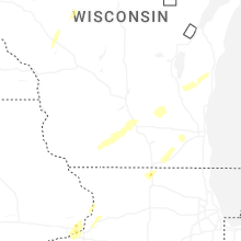
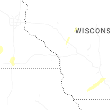
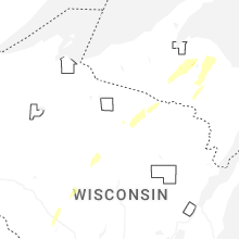
Wisconsin
| Local Time | Report Details |
|---|---|
| 2:15 PM CDT | At 230pm... law enforcement reported ~4 telephone poles down near the intersection of county hwy ff and state hwy 42. damage time estimated from radar (215pm in sheboygan county WI, 46.7 miles SSE of Green Bay, WI |
| 2:56 PM CDT | Large limbs snapped on a healthy tre in calumet county WI, 38 miles SSW of Green Bay, WI |
| 3:07 PM CDT | Damage to barn... trailer flipped. along highway 32/57 southeast of chilton. time estimated from rada in calumet county WI, 36 miles S of Green Bay, WI |
| 3:09 PM CDT | Barn damaged. time estimated from rada in calumet county WI, 34.6 miles S of Green Bay, WI |
| 3:47 PM CDT | Roof damage to barn along state highway 310. time estimated from rada in manitowoc county WI, 28.8 miles SSE of Green Bay, WI |
| 3:50 PM CDT | 3 to 4 trees downed along county road in manitowoc county WI, 30.5 miles SE of Green Bay, WI |
| 3:56 PM CDT | Tree uprooted. time estimated from rada in manitowoc county WI, 33.5 miles SE of Green Bay, WI |
| 4:00 PM CDT | Multiple trees downed and uprooted in two river in manitowoc county WI, 31.3 miles SE of Green Bay, WI |
| 4:00 PM CDT | Downed trees and power lines along sandy bay road just south of lake breeze way. time estimated from rada in manitowoc county WI, 33.4 miles SE of Green Bay, WI |
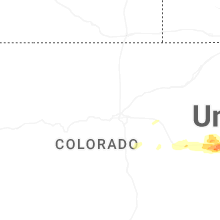
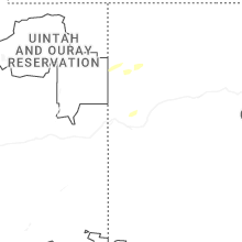
Colorado
| Local Time | Report Details |
|---|---|
| 1:53 PM MDT | Storm damage reported in rio blanco county CO, 37.4 miles SSW of Craig, CO |
| 2:30 PM MDT | Half Dollar sized hail reported near Hayden, CO, 15.3 miles E of Craig, CO |
| 3:04 PM MDT | Storm damage reported in elbert county CO, 72.5 miles ESE of Denver, CO |
| 3:19 PM MDT | Asos station klic limo in lincoln county CO, 77.3 miles SW of Yuma, CO |
| 4:15 PM MDT | Quarter sized hail reported near Seibert, CO, 63.2 miles S of Yuma, CO, trained spotter reports hail up to quarter in size. lots of it that covered the ground. |
| 4:33 PM MDT | Awn; braxma in kit carson county CO, 56.5 miles S of Yuma, CO |
| 4:33 PM MDT | Nws employee reported a fallen tree. the tree appears to be dead. time approximated from rada in kit carson county CO, 56.5 miles S of Yuma, CO |
| 4:39 PM MDT | Quarter sized hail reported near Vona, CO, 62.7 miles S of Yuma, CO, mostly dime & quarter sized hail with a few quarters. |
| 4:59 PM MDT | Asos station kitr burlington co airpor in kit carson county CO, 65.7 miles SSE of Yuma, CO |
| 5:03 PM MDT | Location estimated; measured by anemomete in kit carson county CO, 68.4 miles WSW of Colby, KS |
| 5:04 PM MDT | Ping Pong Ball sized hail reported near Burlington, CO, 71.6 miles SSE of Yuma, CO, time estimated from radar. |
| 5:07 PM MDT | Trained spotter reported a 74 mph gus in kit carson county CO, 68.4 miles WSW of Colby, KS |
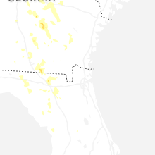
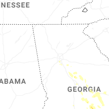
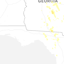
Georgia
| Local Time | Report Details |
|---|---|
| 4:32 PM EDT | Cell tower collapsed and large tree branches down near 400 charter blvd and forest hill roa in bibb county GA, 72.9 miles SE of Atlanta, GA |
| 4:40 PM EDT | Quarter sized hail reported near Jacksonville, GA, 22.3 miles NNW of Douglas, GA, one inch hail reported in jacksonville... ga at water tower rd and north ocmulgee blvd. |
| 5:40 PM EDT | Quarter sized hail reported near Soperton, GA, 62.5 miles NNE of Douglas, GA, one inch hail at ga 29 and union camp rd. |
| 5:40 PM EDT | Berrien county dispatch reported a downed tree on south dogwood d in berrien county GA, 32.1 miles SW of Douglas, GA |
| 6:20 PM EDT | Berrien county dispatch reported downed powelines on mussel white store r in berrien county GA, 34.7 miles WSW of Douglas, GA |
| 6:20 PM EDT | Berrien county dispatch reported a downed tree on hillard week in berrien county GA, 27.3 miles SW of Douglas, GA |
| 6:40 PM EDT | Loss of some roof covering and the side wall of a building collapsed onto parked cars in tifto in tift county GA, 39.2 miles W of Douglas, GA |
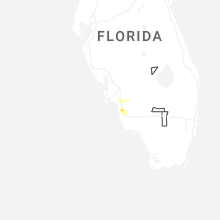
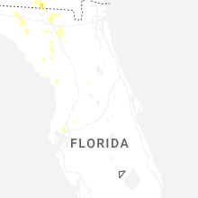
Florida
| Local Time | Report Details |
|---|---|
| 4:35 PM EDT | Tree down near us 90 east of greenville... f in madison county FL, 39.5 miles E of Tallahassee, FL |
| 5:50 PM EDT | Trees and powerlines reported down along county road 150. time estimated from rada in hamilton county FL, 63.5 miles S of Douglas, GA |
| 6:18 PM EDT | Trees were reported down along county road 6 east. time of event based on rada in hamilton county FL, 66.8 miles W of Jacksonville, FL |
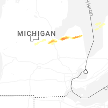
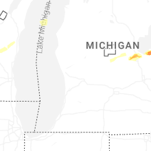
Michigan
| Local Time | Report Details |
|---|---|
| 5:01 PM EDT | Half Dollar sized hail reported near Freeland, MI, 39.4 miles NNW of Flint, MI, half dollar sized hail reported by trained spotter. photo also relayed via social media. |
| 5:08 PM EDT | Quarter sized hail reported near Freeland, MI, 39 miles NNW of Flint, MI, quarter sized hail reported by trained spotter. photo also relayed via social media. |
| 5:22 PM EDT | Quarter sized hail reported near Bay City, MI, 40.2 miles NNW of Flint, MI, amateur radio relayed photo of roughly a dozen quarter sized hail stones in frankenlust twp. |
| 5:31 PM EDT | Half Dollar sized hail reported near Bay City, MI, 40.2 miles NNW of Flint, MI, amateur radio relayed photo of roughly half a dozen half dollar sized hail stones in frankenlust twp. |
| 6:13 PM EDT | Hen Egg sized hail reported near Unionville, MI, 45.4 miles NNE of Flint, MI, media relayed social media photo from public of 2 inch hailstone in unionville. |
| 6:16 PM EDT | Quarter sized hail reported near Unionville, MI, 44.4 miles NNE of Flint, MI, report of quarter sized hail near unionville via both mping and trained spotter report. spotter also noted small branches down in the area. |
| 6:55 PM EDT | Delayed report. images shared by broadcast media of damaged/collapsed roof of an outbuilding. time estimated via rada in manistee county MI, 35.3 miles SW of Traverse City, MI |
| 7:06 PM EDT | Quarter sized hail reported near Ubly, MI, 60.9 miles NE of Flint, MI, media relayed a photo of roughly quarter sized hail near ubly. |
| 7:26 PM EDT | Golf Ball sized hail reported near Ruth, MI, 68.3 miles NE of Flint, MI, media relayed a public report of golf ball sized hail in ruth. |
| 7:26 PM EDT | Tennis Ball sized hail reported near Ruth, MI, 68.3 miles NE of Flint, MI, media relayed a photo of roughly 2.5 inch hailstone in ruth. |
| 7:30 PM EDT | One tree downed across a road. a number of smaller limbs and branches downed. social media repor in wexford county MI, 25.4 miles SSW of Traverse City, MI |
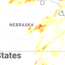
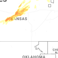
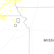
Kansas
| Local Time | Report Details |
|---|---|
| 4:58 PM CDT | Quarter sized hail reported near Esbon, KS, 76.4 miles S of Grand Island, NE |
| 5:36 PM CDT | Half Dollar sized hail reported near Lucas, KS, 44.6 miles ENE of Hays, KS, report from social media with picture. |
| 5:50 PM CDT | Golf Ball sized hail reported near Hunter, KS, 56.4 miles ENE of Hays, KS |
| 6:05 PM CDT | Quarter sized hail reported near Lucas, KS, 44.8 miles ENE of Hays, KS |
| 6:11 PM CDT | Golf Ball sized hail reported near Dorrance, KS, 36.6 miles E of Hays, KS |
| 6:26 PM CDT | Half Dollar sized hail reported near Dorrance, KS, 36.9 miles ESE of Hays, KS, report from mping: half dollar (1.25 in.). |
| 6:34 PM CDT | Quarter sized hail reported near Russell, KS, 30.3 miles ESE of Hays, KS, mostly pea size hail with a few quarters mixed in. |
| 6:35 PM CDT | Quarter sized hail reported near Beloit, KS, 76.7 miles ENE of Hays, KS |
| 6:37 PM CDT | Golf Ball sized hail reported near Dorrance, KS, 39.1 miles E of Hays, KS |
| 6:37 PM CDT | Quarter sized hail reported near Otis, KS, 28 miles SSE of Hays, KS |
| 6:37 PM CDT | Quarter sized hail reported near Russell, KS, 29.8 miles ESE of Hays, KS, report from mping: quarter (1.00 in.). |
| 5:41 PM MDT | Quarter sized hail reported near Goodland, KS, 42.9 miles WSW of Colby, KS, public report of roughly 1 inch hail with video and picture. |
| 5:43 PM MDT | Quarter sized hail reported near Goodland, KS, 42.9 miles WSW of Colby, KS, public report of pictured quarter size hail. |
| 6:46 PM CDT | Half Dollar sized hail reported near Otis, KS, 27.5 miles SSE of Hays, KS, report of half-dollar sized hail with photos. |
| 5:47 PM MDT | Ping Pong Ball sized hail reported near Goodland, KS, 37.5 miles WSW of Colby, KS, social media report estimated 1.5 inch hail with photo; time estimated from radar. |
| 6:00 PM MDT | Half Dollar sized hail reported near Goodland, KS, 34.4 miles WSW of Colby, KS |
| 7:02 PM CDT | Half Dollar sized hail reported near Russell, KS, 29.4 miles ESE of Hays, KS |
| 7:03 PM CDT | Half Dollar sized hail reported near Nekoma, KS, 36.9 miles S of Hays, KS, social media report of half-dollar sized hail. |
| 6:09 PM MDT | Half Dollar sized hail reported near Goodland, KS, 38.4 miles WSW of Colby, KS, quarter to half dollar hail covering the ground. |
| 7:24 PM CDT | Quarter sized hail reported near Brewster, KS, 18.5 miles WSW of Colby, KS, report from mping: quarter (1.00 in.). |
| 7:28 PM CDT | Half Dollar sized hail reported near Wilson, KS, 43.4 miles E of Hays, KS |
| 7:44 PM CDT | Half Dollar sized hail reported near Nekoma, KS, 35.4 miles S of Hays, KS, social media picture of half0dollar size hail. |
| 7:50 PM CDT | Ping Pong Ball sized hail reported near Nekoma, KS, 40 miles S of Hays, KS |
| 7:55 PM CDT | Kcn in cloud county KS, 63.7 miles WNW of Manhattan, KS |
| 7:55 PM CDT | Golf Ball sized hail reported near Minneapolis, KS, 69.2 miles W of Manhattan, KS |
| 7:59 PM CDT | Kcn in cloud county KS, 63.7 miles WNW of Manhattan, KS |
| 8:03 PM CDT | Half Dollar sized hail reported near Nekoma, KS, 36.9 miles S of Hays, KS, corrects previous hail report from 9 s nekoma. social media report of half-dollar sized hail. |
| 8:05 PM CDT | Personal weather statio in ottawa county KS, 63.4 miles W of Manhattan, KS |
| 8:20 PM CDT | Quarter sized hail reported near Beverly, KS, 74.5 miles E of Hays, KS |
| 8:23 PM CDT | Quarter sized hail reported near Hollenberg, KS, 57.8 miles NNW of Manhattan, KS |
| 8:36 PM CDT | Quarter sized hail reported near Lincoln, KS, 65.7 miles E of Hays, KS, reported nickel to quarter size hail covering the ground. |
| 8:40 PM CDT | Golf Ball sized hail reported near Rush Center, KS, 28.9 miles SSE of Hays, KS, report was from social media with photos. |
| 8:49 PM CDT | Half Dollar sized hail reported near Rush Center, KS, 28.4 miles S of Hays, KS, half-dollar sized hail reported. |
| 9:05 PM CDT | 50-60 mph wind in marshall county KS, 47.9 miles NNW of Manhattan, KS |
| 9:06 PM CDT | Hen Egg sized hail reported near Nekoma, KS, 28.3 miles SSW of Hays, KS, report received from social media. |
| 9:10 PM CDT | Ping Pong Ball sized hail reported near Rush Center, KS, 28.9 miles SSE of Hays, KS, mping report of ping ball ball sized hail. |
| 9:29 PM CDT | Golf Ball sized hail reported near Tescott, KS, 71.8 miles W of Manhattan, KS |
| 9:30 PM CDT | Half Dollar sized hail reported near Rush Center, KS, 26.3 miles S of Hays, KS, county dispatch reported half-dollar sized hail. |
| 9:30 PM CDT | Hen Egg sized hail reported near Tescott, KS, 71.8 miles W of Manhattan, KS, delayed report. relayed via photos. |
| 9:35 PM CDT | Quarter sized hail reported near Minneapolis, KS, 59.5 miles W of Manhattan, KS |
| 10:13 PM CDT | Half Dollar sized hail reported near Hoisington, KS, 30.5 miles ESE of Hays, KS |
| 10:19 PM CDT | Hen Egg sized hail reported near Russell, KS, 30.1 miles ESE of Hays, KS, 2.25 inch hail measured. |
| 10:53 PM CDT | Golf Ball sized hail reported near Wilson, KS, 46.6 miles E of Hays, KS |
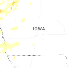
Iowa
| Local Time | Report Details |
|---|---|
| 5:14 PM CDT | Half Dollar sized hail reported near Rock Rapids, IA, 22.9 miles ESE of Sioux Falls, SD, social media report with picture and coin for size comparison. time estimated by radar. |
| 6:43 PM CDT | Golf Ball sized hail reported near Le Mars, IA, 50.4 miles SSE of Sioux Falls, SD, photo via social media. time estimated via radar. |
| 6:50 PM CDT | Half Dollar sized hail reported near Le Mars, IA, 49.4 miles SSE of Sioux Falls, SD, photo via social media. time estimated by radar. |
| 7:23 PM CDT | Tree branches 10-12 inches in diameter downed. time estimated from rada in woodbury county IA, 60.6 miles W of Storm Lake, IA |
| 7:29 PM CDT | Via personal weather station. exact time estimated via rada in woodbury county IA, 62 miles WSW of Storm Lake, IA |
| 7:36 PM CDT | Via personal weather station. exact time estimated via rada in woodbury county IA, 58 miles WSW of Storm Lake, IA |
| 7:48 PM CDT | Personal weather statio in monona county IA, 47.7 miles SW of Storm Lake, IA |
| 7:48 PM CDT | Via personal weather statio in woodbury county IA, 51.8 miles WSW of Storm Lake, IA |
| 7:49 PM CDT | Via personal weather statio in woodbury county IA, 45.1 miles WSW of Storm Lake, IA |
| 7:50 PM CDT | Via personal weather station. exact time estimated via rada in woodbury county IA, 45.1 miles WSW of Storm Lake, IA |
| 7:54 PM CDT | Via personal weather station. exact time estimated via rada in woodbury county IA, 35.5 miles WSW of Storm Lake, IA |
| 7:56 PM CDT | Via personal weather station. exact time estimated via rada in woodbury county IA, 43.2 miles WSW of Storm Lake, IA |
| 7:57 PM CDT | Via personal weather station. exact time estimated via rada in woodbury county IA, 35.5 miles WSW of Storm Lake, IA |
| 8:09 PM CDT | Golf Ball sized hail reported near Sanborn, IA, 41.2 miles NW of Storm Lake, IA, report from mping: golf ball (1.75 in.). |
| 8:22 PM CDT | Mesonet station rigi4 ida grov in ida county IA, 25 miles SW of Storm Lake, IA |
| 8:29 PM CDT | Via personal weather station. exact time estimated via rada in cherokee county IA, 30.4 miles WNW of Storm Lake, IA |
| 8:29 PM CDT | Awos station kckp cherokee municipal airpor in cherokee county IA, 18.6 miles WNW of Storm Lake, IA |
| 8:31 PM CDT | Via personal weather statio in cherokee county IA, 24.2 miles WNW of Storm Lake, IA |
| 8:33 PM CDT | Personal weather statio in harrison county IA, 19.5 miles N of Omaha, NE |
| 8:35 PM CDT | Awos station kslb storm lake airpor in buena vista county IA, 3.4 miles SSW of Storm Lake, IA |
| 8:48 PM CDT | Via personal weather statio in buena vista county IA, 14 miles ENE of Storm Lake, IA |
| 8:49 PM CDT | Damage to the greenville grain elevator. branches and power lines also downed. time estimated from rada in clay county IA, 25.8 miles N of Storm Lake, IA |
| 8:51 PM CDT | Via personal weather statio in buena vista county IA, 15.3 miles ENE of Storm Lake, IA |
| 8:55 PM CDT | Storm damage reported in sac county IA, 19.1 miles SE of Storm Lake, IA |
| 9:10 PM CDT | Delayed report - report of trees and power lines down in rockwell city. time estimated from rada in calhoun county IA, 33.8 miles ESE of Storm Lake, IA |
| 9:12 PM CDT | Via personal weather statio in dickinson county IA, 48.6 miles N of Storm Lake, IA |
| 9:16 PM CDT | Personal weather statio in pottawattamie county IA, 27.7 miles E of Omaha, NE |
| 9:19 PM CDT | Personal weather statio in montgomery county IA, 32.3 miles ESE of Omaha, NE |
| 9:23 PM CDT | 2-3 inch diameter limbs down. time estimated via rada in emmet county IA, 55.9 miles NNE of Storm Lake, IA |
| 9:33 PM CDT | Delayed report - received photo on social media of large tree limb on hom in kossuth county IA, 52.3 miles W of Mason City, IA |
| 9:33 PM CDT | Tree uprooted near lone rock. delayed report from broadcast media... time estimated by rada in kossuth county IA, 56.8 miles W of Mason City, IA |
| 9:34 PM CDT | Semi tipped ove in webster county IA, 49.9 miles ESE of Storm Lake, IA |
| 9:39 PM CDT | Downed tree limb on home. time estimated via rada in kossuth county IA, 52.3 miles W of Mason City, IA |
| 9:41 PM CDT | Asos station kest estherville airpor in emmet county IA, 56.8 miles NNE of Storm Lake, IA |
| 9:42 PM CDT | Couple of trees down. time estimated via rada in kossuth county IA, 55.9 miles WNW of Mason City, IA |
| 10:10 PM CDT | Storm damage reported in winnebago county IA, 37.3 miles WNW of Mason City, IA |
| 10:18 PM CDT | Storm damage reported in cerro gordo county IA, 6.3 miles SSW of Mason City, IA |
| 10:25 PM CDT | Storm damage reported in cerro gordo county IA, 4.2 miles WNW of Mason City, IA |
| 10:34 PM CDT | Storm damage reported in floyd county IA, 9.7 miles E of Mason City, IA |
| 3:51 AM CDT | Half Dollar sized hail reported near Bettendorf, IA, 67.8 miles ESE of Cedar Rapids, IA, half dollar size hail reported by off duty nws employee. |
| 3:54 AM CDT | Quarter sized hail reported near Bettendorf, IA, 67.1 miles ESE of Cedar Rapids, IA |
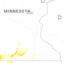
Minnesota
| Local Time | Report Details |
|---|---|
| 5:18 PM CDT | Mesonet station mn006 i-90 - beaver creek mp in rock county MN, 18.2 miles ENE of Sioux Falls, SD |
| 5:26 PM CDT | Awos station klyv luverne airpor in rock county MN, 26.2 miles ENE of Sioux Falls, SD |
| 5:36 PM CDT | Half Dollar sized hail reported near Magnolia, MN, 32.4 miles E of Sioux Falls, SD, report from mping. |
| 5:44 PM CDT | Via personal weather station. exact time estimated via rada in nobles county MN, 43.2 miles ENE of Sioux Falls, SD |
| 5:50 PM CDT | Ping Pong Ball sized hail reported near Adrian, MN, 40.8 miles E of Sioux Falls, SD |
| 5:54 PM CDT | Golf Ball sized hail reported near Lismore, MN, 41.6 miles ENE of Sioux Falls, SD |
| 6:01 PM CDT | Mesonet station mn160 u.s.14 - florence - mp 21.2. time estimated via rada in lyon county MN, 51.8 miles SSW of Montevideo, MN |
| 6:01 PM CDT | Half Dollar sized hail reported near Wilmont, MN, 47.5 miles ENE of Sioux Falls, SD, mping: half dollar (1.25 in.). time estimated via radar. |
| 6:18 PM CDT | Quarter sized hail reported near Worthington, MN, 54.3 miles E of Sioux Falls, SD, report from mping: time estimated via radar. |
| 6:22 PM CDT | Quarter sized hail reported near Fulda, MN, 60.7 miles ENE of Sioux Falls, SD, mping: quarter (1.00 in.). time estimated via radar. |
| 6:24 PM CDT | Quarter sized hail reported near Fulda, MN, 60.9 miles ENE of Sioux Falls, SD, picture with 1 inch hailstone and ruler. |
| 6:26 PM CDT | Via personal weather station. exact time estimated via rada in nobles county MN, 57.7 miles E of Sioux Falls, SD |
| 10:11 PM CDT | Storm damage reported in kossuth county IA, 50.7 miles WNW of Mason City, IA |
| 10:42 PM CDT | Storm damage reported in mower county MN, 36.7 miles NNE of Mason City, IA |
| 10:57 PM CDT | Storm damage reported in mower county MN, 38 miles NNE of Mason City, IA |
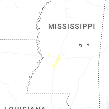
Mississippi
| Local Time | Report Details |
|---|---|
| 6:02 PM CDT | Corrects time and source of previous tstm wnd dmg report from 4 w terry. trees and power lines were blown down in 5 or 6 locations near midway road between tank road an in hinds county MS, 17.1 miles SW of Jackson, MS |
| 6:08 PM CDT | A 64 mph wind gust was measured with a handheld anemometer along w flowers r in hinds county MS, 13.4 miles SW of Jackson, MS |
| 6:15 PM CDT | Quarter sized hail reported near Terry, MS, 13.4 miles SW of Jackson, MS, reported along w flowers rd. |
| 6:30 PM CDT | A few trees and power lines were blown down along springridge road between raymond road and the southern city limits for clinto in hinds county MS, 9.4 miles W of Jackson, MS |
| 6:35 PM CDT | A tree was blown down along belknap roa in hinds county MS, 23 miles W of Jackson, MS |
| 6:39 PM CDT | Quarter sized hail reported near Jackson, MS, 4.9 miles WSW of Jackson, MS, reported along lakewood dr. |
| 6:52 PM CDT | Tree limbs were blown down across mitchell roa in copiah county MS, 21.6 miles SW of Jackson, MS |
| 7:42 PM CDT | Trees and power lines were blown down in 5 or 6 locations near midway road between tank road and owens roa in hinds county MS, 17.1 miles SW of Jackson, MS |
Missouri
| Local Time | Report Details |
|---|---|
| 10:37 PM CDT | Pws measured 62 mph wind gusts northeast of westbor in atchison county MO, 59.4 miles SE of Omaha, NE |
| 11:06 PM CDT | Pws measured 58 mph wind gust north of maryvill in nodaway county MO, 81.5 miles SE of Omaha, NE |
| 11:12 PM CDT | Report of trees blown over... time estimated from rada in nodaway county MO, 84.3 miles SE of Omaha, NE |
| 11:15 PM CDT | Storm damage reported in nodaway county MO, 82.5 miles SE of Omaha, NE |
| 3:05 AM CDT | Storm damage reported in adair county MO, 49 miles WSW of Kahoka, MO |
Connect with Interactive Hail Maps