

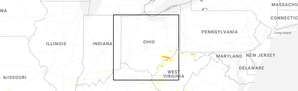
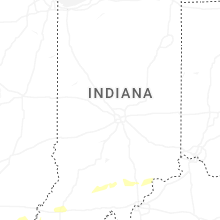
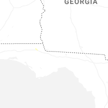
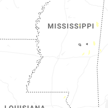
Hail Map for Wednesday, April 1, 2026
Number of Impacted Households on 4/1/2026
0
Impacted by 1" or Larger Hail
0
Impacted by 1.75" or Larger Hail
0
Impacted by 2.5" or Larger Hail
Square Miles of Populated Area Impacted on 4/1/2026
0
Impacted by 1" or Larger Hail
0
Impacted by 1.75" or Larger Hail
0
Impacted by 2.5" or Larger Hail

Cities Most Affected by Hail Storms of 4/1/2026
| Hail Size | Demographics of Zip Codes Affected | ||||||
|---|---|---|---|---|---|---|---|
| City | Count | Average | Largest | Pop Density | House Value | Income | Age |
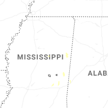
| Omega, OK | 1 | 2.50 | 2.50 | 3 | $64k | $43.3k | 46.5 |
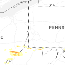
| West Liberty, KY | 1 | 1.75 | 1.75 | 34 | $59k | $22.0k | 38.6 |
| Summerfield, OH | 1 | 1.75 | 1.75 | 22 | $37k | $30.4k | 38.0 |
| Watonga, OK | 1 | 1.75 | 1.75 | 16 | $47k | $27.7k | 33.5 |
| Lewisville, OH | 1 | 1.75 | 1.75 | 18 | $65k | $28.9k | 42.8 |
Hail and Wind Damage Spotted on 4/1/2026
Filter by Report Type:Hail ReportsWind Reports
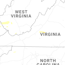
States Impacted
Virginia, North Carolina, West Virginia, Ohio, Indiana, Kentucky, Maryland, Texas, Oklahoma, Missouri, New Mexico, Delaware, Oregon, WashingtonVirginia
| Local Time | Report Details |
|---|---|
| 2:08 PM EDT | Quarter sized hail reported near Bedford, VA, 22.7 miles ENE of Roanoke, VA |
| 2:12 PM EDT | Quarter sized hail reported near Bedford, VA, 24.1 miles ENE of Roanoke, VA, hail of around 1 in diameter was observed along wheats valley road. |
| 2:41 PM EDT | Quarter sized hail reported near Lynchburg, VA, 37.6 miles ENE of Roanoke, VA, hail of at least 1 inch in diameter was observed along mcintosh drive. |
| 2:43 PM EDT | Ping Pong Ball sized hail reported near Forest, VA, 35.5 miles ENE of Roanoke, VA |
| 2:50 PM EDT | Quarter sized hail reported near Lynchburg, VA, 40.1 miles ENE of Roanoke, VA |
| 2:54 PM EDT | Quarter sized hail reported near Forest, VA, 35.7 miles ENE of Roanoke, VA, report relayed from wset/abc13. |
| 4:35 PM EDT | Quarter sized hail reported near Clifton, VA, 54.8 miles SW of Baltimore, MD |
| 4:47 PM EDT | Quarter sized hail reported near Manassas, VA, 57.7 miles SW of Baltimore, MD |
| 5:08 PM EDT | Quarter sized hail reported near Clifton, VA, 54.8 miles SW of Baltimore, MD |
| 5:09 PM EDT | Quarter sized hail reported near Vinton, VA, 5.6 miles E of Roanoke, VA |
| 6:45 PM EDT | Multiple reports of trees down in covesvill in albemarle county VA, 64.1 miles WNW of Richmond, VA |
| 7:02 PM EDT | Tree down along cornfield lan in appomattox county VA, 60.8 miles E of Roanoke, VA |
| 7:03 PM EDT | Tree down on power lines along church stree in appomattox county VA, 61.4 miles E of Roanoke, VA |
| 7:03 PM EDT | Tree down along redfields roa in appomattox county VA, 61.9 miles E of Roanoke, VA |
| 7:11 PM EDT | Tree down along old courthouse roa in appomattox county VA, 62.6 miles W of Richmond, VA |
| 7:11 PM EDT | Corrects previous tstm wnd dmg report from 4 e appomattox. tree down along river ridge roa in appomattox county VA, 61.7 miles W of Richmond, VA |
| 7:11 PM EDT | Corrects previous tstm wnd dmg report from 4 e appomattox. tree down along river ridge roa in appomattox county VA, 61.7 miles W of Richmond, VA |
| 8:56 PM EDT | Tree down across both lanes of daniels creek roa in henry county VA, 36 miles S of Roanoke, VA |
| 9:00 PM EDT | Tree down blocking hidden valley driv in henry county VA, 33.4 miles S of Roanoke, VA |
North Carolina
| Local Time | Report Details |
|---|---|
| 2:14 PM EDT | Quarter sized hail reported near Deep Gap, NC, 47.3 miles ESE of Bristol, TN |
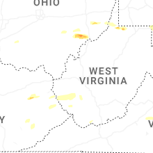
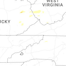
West Virginia
| Local Time | Report Details |
|---|---|
| 2:20 PM EDT | Half Dollar sized hail reported near Crum, WV, 48.8 miles SW of Charleston, WV, trained spotter near crum... wv measured half dollar size hail. |
| 3:05 PM EDT | 500 customers without power due to tree damage in the pecks mill are in logan county WV, 33 miles SSW of Charleston, WV |
| 3:31 PM EDT | Tree down along bulldog boulevard. time estimated from rada in mingo county WV, 53.1 miles SW of Charleston, WV |
| 4:03 PM EDT | Quarter sized hail reported near Daniels, WV, 50.4 miles SSE of Charleston, WV |
| 4:12 PM EDT | Quarter sized hail reported near Daniels, WV, 50.4 miles SSE of Charleston, WV |
| 4:28 PM EDT | Tree down on road. time estimated from rada in monongalia county WV, 48.7 miles N of Elkins, WV |
| 4:38 PM EDT | Corrects previous tstm wnd dmg report from beckley. tree reported down. time is estimated by rada in raleigh county WV, 46.6 miles SSE of Charleston, WV |
| 4:43 PM EDT | Tree down. time estimated from rada in raleigh county WV, 46 miles SSE of Charleston, WV |
| 4:44 PM EDT | Tree down on crossroads road. time estimated from rada in monongalia county WV, 53.2 miles SSW of Pittsburgh, PA |
| 4:46 PM EDT | Tree and power lines down. time estimated from rada in raleigh county WV, 47.4 miles SE of Charleston, WV |
| 4:50 PM EDT | Tree down on clyburn st. in spragu in raleigh county WV, 45.7 miles SSE of Charleston, WV |
| 5:15 PM EDT | Ping Pong Ball sized hail reported near Williamstown, WV, 73.1 miles N of Charleston, WV, report from mping: ping pong ball (1.50 in.). |
| 5:17 PM EDT | Quarter sized hail reported near Williamstown, WV, 73.1 miles N of Charleston, WV, time is estimated by radar. |
| 5:18 PM EDT | Ping Pong Ball sized hail reported near Williamstown, WV, 73.1 miles N of Charleston, WV, ping-pong sized hail. cocorahs station wd-7. |
| 5:40 PM EDT | Quarter sized hail reported near Belmont, WV, 73.9 miles NNE of Charleston, WV, size estimated from a photo on social media. time is estimated by radar. |
| 5:40 PM EDT | Quarter sized hail reported near Saint Marys, WV, 74.7 miles NNE of Charleston, WV |
| 5:49 PM EDT | Quarter sized hail reported near Parkersburg, WV, 64.3 miles N of Charleston, WV, a couple of simultaneous reports of quarter-sized hail in parkersburg... one on 19th street. |
| 5:52 PM EDT | Tree dow in wood county WV, 64.4 miles N of Charleston, WV |
| 5:53 PM EDT | Power lines down along 22nd stree in wood county WV, 64.4 miles N of Charleston, WV |
| 5:57 PM EDT | Power lines down. time estimated from rada in wood county WV, 62.8 miles N of Charleston, WV |
| 5:59 PM EDT | Tree down on car and she in wood county WV, 63.8 miles N of Charleston, WV |
| 6:01 PM EDT | Tree down on a hous in wood county WV, 64.4 miles N of Charleston, WV |
| 6:04 PM EDT | Corrects previous non-tstm wnd dmg report from 5 ne mineral wells. tree across little stillwell roa in wood county WV, 61.5 miles N of Charleston, WV |
| 6:07 PM EDT | Tree along robert byrd highway and progress ridge road blocking traffi in wood county WV, 63.7 miles NNE of Charleston, WV |
| 6:08 PM EDT | Trees down in hazleton. time estimated from rada in preston county WV, 52.7 miles NNE of Elkins, WV |
| 6:22 PM EDT | Tree down blocking glendale road in cairo. time estimated from rada in ritchie county WV, 71.9 miles NNE of Charleston, WV |
| 6:31 PM EDT | Tree down in lines. time estimated from rada in pleasants county WV, 70.4 miles WNW of Elkins, WV |
| 6:33 PM EDT | Tree and power lines down. time estimated from rada in ritchie county WV, 69.8 miles WNW of Elkins, WV |
| 6:40 PM EDT | Tree in roadway on wv-14 & rose hill rd. time estimated from rada in wirt county WV, 51.7 miles NNE of Charleston, WV |
| 6:42 PM EDT | Tree down blocking gnats run road. time estimated from rada in ritchie county WV, 66.1 miles WNW of Elkins, WV |
| 6:52 PM EDT | Tree reported down in roadwa in doddridge county WV, 58.5 miles WNW of Elkins, WV |
| 7:35 PM EDT | Tree down along 2nd street in clarksburg... time estimated from rada in harrison county WV, 36.2 miles NW of Elkins, WV |
| 7:35 PM EDT | Tree down along 2nd street in clarksburg... time estimated from rada in harrison county WV, 36.2 miles NW of Elkins, WV |
| 7:35 PM EDT | Storm damage reported in harrison county WV, 37.4 miles NW of Elkins, WV |
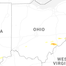
Ohio
| Local Time | Report Details |
|---|---|
| 2:20 PM EDT | Golf Ball sized hail reported near Summerfield, OH, 85.3 miles WSW of Pittsburgh, PA, size estimated from social media. |
| 2:23 PM EDT | Quarter sized hail reported near Summerfield, OH, 83.9 miles WSW of Pittsburgh, PA |
| 2:28 PM EDT | Golf Ball sized hail reported near Lewisville, OH, 81.3 miles WSW of Pittsburgh, PA, observed along bracken ridge rd. |
| 4:41 PM EDT | Tree into powerlines and powerlines on fire at state rt 550 and murphy r in washington county OH, 72 miles ESE of Columbus, OH |
| 5:14 PM EDT | Caller witnessed part of a roof blown off of a nearby house. time estimated from rada in washington county OH, 74.7 miles N of Charleston, WV |
| 5:15 PM EDT | Quarter sized hail reported near Marietta, OH, 72.5 miles N of Charleston, WV |
| 5:16 PM EDT | Quarter sized hail reported near Marietta, OH, 74.6 miles N of Charleston, WV |
| 5:16 PM EDT | Quarter sized hail reported near Marietta, OH, 75.2 miles N of Charleston, WV, hail up to 1.1 in and accumulation of smaller hail. |
| 5:16 PM EDT | Ping Pong Ball sized hail reported near Marietta, OH, 74.5 miles N of Charleston, WV, from photo provided to the media. time is estimated from radar. |
| 5:17 PM EDT | Half Dollar sized hail reported near Athens, OH, 64.5 miles SE of Columbus, OH, photos include pictures of between half dollar to ping pong ball size hail. |
| 5:17 PM EDT | Quarter sized hail reported near Marietta, OH, 73.8 miles N of Charleston, WV |
| 5:17 PM EDT | Half Dollar sized hail reported near Marietta, OH, 73.9 miles N of Charleston, WV, report from mping: half dollar (1.25 in.). time is estimated from radar. |
| 5:19 PM EDT | Quarter sized hail reported near Marietta, OH, 74.7 miles N of Charleston, WV, corrects previous hail report from 1 ese marietta. large hail estimated at half inch to quarter size. time estimated from radar. |
| 5:19 PM EDT | Large hail estimated at half inch to quarter size. time estimated from rada in washington county OH, 74.7 miles N of Charleston, WV |
| 5:20 PM EDT | Power lines down along pike street in mariett in washington county OH, 74.1 miles N of Charleston, WV |
| 5:20 PM EDT | Quarter sized hail reported near Marietta, OH, 74.1 miles N of Charleston, WV, photo showing quarter size hail. |
| 5:22 PM EDT | Half Dollar sized hail reported near Marietta, OH, 73.5 miles N of Charleston, WV, report from mping: half dollar (1.25 in.). |
| 5:44 PM EDT | Sign blown off business. time estimated from rada in meigs county OH, 50.6 miles NNW of Charleston, WV |
| 6:17 PM EDT | Large tree down blocking ohio avenue. time estimated from rada in gallia county OH, 44.6 miles NW of Charleston, WV |
Indiana
| Local Time | Report Details |
|---|---|
| 4:16 PM EDT | Tree was reported down blocking roadway at n. k rd and old sr 62. time estimated by rada in jefferson county IN, 50.8 miles WSW of Cincinnati, OH |
| 7:01 PM EDT | Photo on facebook showing a large pine tree uprooted. time estimated via radar. delayed repor in de kalb county IN, 16.9 miles NNE of Fort Wayne, IN |
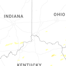
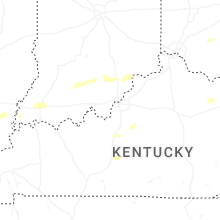
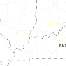
Kentucky
| Local Time | Report Details |
|---|---|
| 4:20 PM EDT | Quarter sized hail reported near West Liberty, KY, 38.4 miles ENE of Irvine, KY, social media video shows pile of approximately quarter sized hail near west liberty. time estimated by radar. |
| 4:27 PM EDT | Small branches down with heavy rain... at least 60 mph wind in shelby county KY, 31.7 miles ENE of Louisville, KY |
| 4:27 PM EDT | Ping Pong Ball sized hail reported near West Liberty, KY, 41.4 miles ENE of Irvine, KY, social media user shared photo of hail stone and estimates ping pong size. hail was retrieved off of liberty rd near arh hospital. time estimated from radar. |
| 4:29 PM EDT | Golf Ball sized hail reported near West Liberty, KY, 41.2 miles ENE of Irvine, KY, social media user posted a video of hail and reported golf ball sized hailstones near the intersection of ky519 and ky7. time estimated by radar. |
| 4:49 PM EDT | Quarter sized hail reported near West Liberty, KY, 49.8 miles ENE of Irvine, KY, social media video of lots of hail falling along ky-589... about 1.5 miles from its intersection with ky-172. the individual reports that the largest hail stones were q |
| 3:59 PM CDT | Tree down blocking roadway on sims cemetery rd. time estimated from rada in hart county KY, 46.7 miles S of Louisville, KY |
| 5:41 PM EDT | Broadcast media relayed pictures of a metal garage roof torn off. time estimated from rada in nelson county KY, 19.3 miles ESE of Louisville, KY |
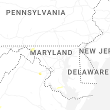
Maryland
| Local Time | Report Details |
|---|---|
| 6:23 PM EDT | Tree reported down in sang run are in garrett county MD, 49.8 miles NNE of Elkins, WV |
| 6:56 PM EDT | Quarter sized hail reported near Williamsport, MD, 67.4 miles WNW of Baltimore, MD |
| 11:02 PM EDT | Tree down on st johns road near intersection with three notch roa in st. marys county MD, 66.3 miles S of Baltimore, MD |
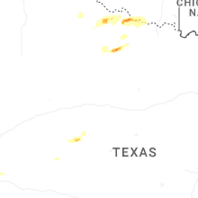
Texas
| Local Time | Report Details |
|---|---|
| 5:40 PM CDT | Also gusted to 61 mph at 536 pm cdt. measured by childress aso in childress county TX, 3.9 miles W of Childress, TX |
| 5:45 PM CDT | West texas mesone in childress county TX, 2.2 miles NNE of Childress, TX |
| 6:31 PM CDT | Power poles/lines dow in hardeman county TX, 29.4 miles ESE of Childress, TX |
| 6:38 PM CDT | Initial gust of 69 mph at 6:36 pm cdt. west texas mesone in king county TX, 59.9 miles S of Childress, TX |
| 6:50 PM CDT | Storm damage reported in scurry county TX, 71 miles WNW of Abilene, TX |
| 6:57 PM CDT | Storm damage reported in scurry county TX, 67.7 miles WNW of Abilene, TX |
| 7:27 PM CDT | Quarter sized hail reported near Vernon, TX, 51.9 miles WNW of Wichita Falls, TX, delayed report. report from mping: quarter (1.00 in.). |
| 7:27 PM CDT | Storm damage reported in fisher county TX, 50.7 miles WNW of Abilene, TX |
| 7:50 PM CDT | Couple power lines blown down in tow in stonewall county TX, 55.5 miles NNW of Abilene, TX |
| 8:02 PM CDT | Storm damage reported in reagan county TX, 47.6 miles ESE of Odessa, TX |
| 8:09 PM CDT | Roof damag in scurry county TX, 71.1 miles WNW of Abilene, TX |
| 8:15 PM CDT | Storm damage reported in knox county TX, 69.3 miles N of Abilene, TX |
| 8:20 PM CDT | Storm damage reported in knox county TX, 69.3 miles N of Abilene, TX |
| 8:22 PM CDT | Storm damage reported in haskell county TX, 60.2 miles N of Abilene, TX |
| 8:30 PM CDT | Storm damage reported in knox county TX, 69.3 miles N of Abilene, TX |
| 8:30 PM CDT | Storm damage reported in knox county TX, 66.1 miles WSW of Wichita Falls, TX |
| 8:30 PM CDT | Storm damage reported in knox county TX, 66.4 miles WSW of Wichita Falls, TX |
| 8:50 PM CDT | Storm damage reported in baylor county TX, 50.1 miles WSW of Wichita Falls, TX |
| 9:22 PM CDT | Storm damage reported in archer county TX, 19.7 miles WSW of Wichita Falls, TX |
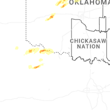
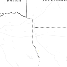
Oklahoma
| Local Time | Report Details |
|---|---|
| 5:47 PM CDT | Tennis Ball sized hail reported near Omega, OK, 51.2 miles WNW of Oklahoma City, OK, report from mping: tennis ball (2.50 in.). |
| 5:57 PM CDT | Quarter sized hail reported near Mulhall, OK, 44.7 miles N of Oklahoma City, OK, report from mping: quarter (1.00 in.). |
| 6:03 PM CDT | Golf Ball sized hail reported near Watonga, OK, 54 miles WNW of Oklahoma City, OK, report from x with pictures. |
| 6:15 PM CDT | Storm damage reported in harmon county OK, 27.3 miles NE of Childress, TX |
| 6:45 PM CDT | Storm damage reported in greer county OK, 51.9 miles ENE of Childress, TX |
| 7:00 PM CDT | Storm damage reported in jackson county OK, 60 miles ENE of Childress, TX |
| 7:35 PM CDT | Storm damage reported in custer county OK, 70.5 miles W of Oklahoma City, OK |
| 7:40 PM CDT | Quarter sized hail reported near Weatherford, OK, 67.2 miles W of Oklahoma City, OK, delayed report. report from mping: quarter (1.00 in.). |
| 9:03 PM CDT | Quarter sized hail reported near Cleveland, OK, 27 miles WNW of Tulsa, OK, report relayed by amateur radio operator... also estimated 60mph wind. |
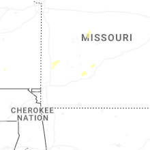
Missouri
| Local Time | Report Details |
|---|---|
| 5:50 PM CDT | High winds broke at least 3 3-phase poles... causing power outages for over 649 members west of lebanon toward long lan in dallas county MO, 34.7 miles NE of Springfield, MO |
New Mexico
| Local Time | Report Details |
|---|---|
| 4:51 PM MDT | Storm damage reported in lea county NM, 69.4 miles E of Roswell, NM |
Delaware
| Local Time | Report Details |
|---|---|
| 7:30 PM EDT | Several reports of large trees and power lines down in clayton. time estimated from rada in kent county DE, 52.5 miles E of Baltimore, MD |
| 7:30 PM EDT | Tree down onto a house in the clayton courts neighborhood. time estimated from rada in kent county DE, 52.5 miles E of Baltimore, MD |
| 7:34 PM EDT | Several reports of large trees and power lines down in smyrna. time estimated from rada in kent county DE, 54.1 miles E of Baltimore, MD |
| 11:19 PM EDT | Multiple reports of trees down in milford. time estimated from rada in sussex county DE, 43.8 miles NNW of Ocean City, MD |
Oregon
| Local Time | Report Details |
|---|---|
| 5:06 PM PDT | Asos station kpdt pendleton... or (airport in umatilla county OR, 34.8 miles SW of Walla Walla, WA |
| 5:13 PM PDT | Mesonet station od185 i84 wb at cabbage hill mp223.5 in umatilla county OR, 35.4 miles SSW of Walla Walla, WA |
Washington
| Local Time | Report Details |
|---|---|
| 6:20 PM PDT | Report of a tree blown down. time estimated from rada in walla walla county WA, 16.6 miles NNE of Walla Walla, WA |
Connect with Interactive Hail Maps