

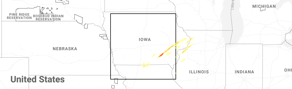
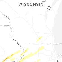
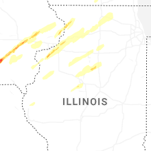
Hail Map for Thursday, April 2, 2026
Number of Impacted Households on 4/2/2026
0
Impacted by 1" or Larger Hail
0
Impacted by 1.75" or Larger Hail
0
Impacted by 2.5" or Larger Hail
Square Miles of Populated Area Impacted on 4/2/2026
0
Impacted by 1" or Larger Hail
0
Impacted by 1.75" or Larger Hail
0
Impacted by 2.5" or Larger Hail
Cities Most Affected by Hail Storms of 4/2/2026
| Hail Size | Demographics of Zip Codes Affected | ||||||
|---|---|---|---|---|---|---|---|
| City | Count | Average | Largest | Pop Density | House Value | Income | Age |
| Hedrick, IA | 2 | 2.50 | 3.00 | 10 | $40k | $35.1k | 41.0 |
| Thomson, IL | 2 | 2.38 | 3.00 | 41 | $83k | $39.9k | 48.9 |
| Ottumwa, IA | 2 | 2.38 | 2.75 | 133 | $51k | $31.9k | 39.1 |
| Mercer, MO | 1 | 1.75 | 1.75 | 6 | $28k | $26.4k | 46.0 |
| Lowden, IA | 1 | 1.75 | 1.75 | 15 | $69k | $38.8k | 44.4 |
| Tipton, IA | 1 | 1.75 | 1.75 | 38 | $87k | $39.1k | 43.3 |
| Iowa City, IA | 1 | 1.75 | 1.75 | 207 | $121k | $35.3k | 26.9 |
| Kalona, IA | 1 | 1.75 | 1.75 | 60 | $107k | $34.6k | 37.1 |
Hail and Wind Damage Spotted on 4/2/2026
Filter by Report Type:Hail ReportsWind Reports
Idaho
| Local Time | Report Details |
|---|---|
| 6:33 AM MDT | Mesonet station grai1 grac in caribou county ID, 66.4 miles S of Idaho Falls, ID |
Utah
| Local Time | Report Details |
|---|---|
| 7:45 AM MDT | Measured at the university of utah syracuse causeway sit in davis county UT, 25.8 miles NNW of Salt Lake City, UT |
| 7:59 AM MDT | Measured at the ogden hinckley airport aso in weber county UT, 30.5 miles NNW of Salt Lake City, UT |
| 8:00 AM MDT | Measured at the interstate 15 and antelope drive udot rwis senso in davis county UT, 23.4 miles NNW of Salt Lake City, UT |
| 8:00 AM MDT | A trained spotter found a snapped power pole had landed on a vehicle. time estimated by rada in weber county UT, 30.2 miles N of Salt Lake City, UT |
| 8:00 AM MDT | Medium sized tree branches snapped due to thunderstorm winds. time estimated by rada in weber county UT, 30.3 miles N of Salt Lake City, UT |
| 8:00 AM MDT | A trained spotter reported small branches down near the ogden golf and country club. time estimated by rada in weber county UT, 30 miles N of Salt Lake City, UT |
| 8:00 AM MDT | A streetlight was knocked over due to thunderstorm winds. time estimated by rada in weber county UT, 30.7 miles N of Salt Lake City, UT |
| 8:00 AM MDT | Trained spotter reported multiple medium sized trees snapped in leavitts mortuary and aultorest memorial park in ogden. time estimated by rada in weber county UT, 30.6 miles N of Salt Lake City, UT |
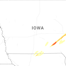
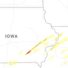
Iowa
| Local Time | Report Details |
|---|---|
| 1:45 PM CDT | Time estimated from radar. measured from personal weather statio in clarke county IA, 41.8 miles SSW of Des Moines, IA |
| 3:11 PM CDT | Quarter sized hail reported near Ottumwa, IA, 55.3 miles NW of Kahoka, MO |
| 3:13 PM CDT | Baseball sized hail reported near Ottumwa, IA, 56.5 miles NW of Kahoka, MO, time estimated by radar. public report relayed from broadcast media. |
| 3:17 PM CDT | Half Dollar sized hail reported near Ottumwa, IA, 55 miles NW of Kahoka, MO, report from mping: half dollar (1.25 in.). |
| 3:17 PM CDT | Ping Pong Ball sized hail reported near Ottumwa, IA, 55.5 miles NW of Kahoka, MO, report from mping: ping pong ball (1.50 in.). |
| 3:19 PM CDT | Hen Egg sized hail reported near Ottumwa, IA, 55.9 miles NW of Kahoka, MO, report from mping: hen egg (2.00 in.). |
| 3:22 PM CDT | Ping Pong Ball sized hail reported near Hedrick, IA, 57 miles NNW of Kahoka, MO |
| 3:30 PM CDT | Measured from personal weather statio in wapello county IA, 56 miles NNW of Kahoka, MO |
| 3:30 PM CDT | Hen Egg sized hail reported near Hedrick, IA, 58.6 miles NNW of Kahoka, MO, report from mping: hen egg (2.00 in.). |
| 3:32 PM CDT | Tea Cup sized hail reported near Hedrick, IA, 58.4 miles NNW of Kahoka, MO, time estimated from radar. public report relayed by broadcast media. |
| 3:35 PM CDT | Half Dollar sized hail reported near Ollie, IA, 57.7 miles SSW of Cedar Rapids, IA |
| 3:59 PM CDT | Storm damage reported in iowa county IA, 31.3 miles SW of Cedar Rapids, IA |
| 4:13 PM CDT | Golf Ball sized hail reported near Kalona, IA, 33.6 miles S of Cedar Rapids, IA |
| 4:31 PM CDT | Golf Ball sized hail reported near Iowa City, IA, 25 miles SSE of Cedar Rapids, IA, media. |
| 4:56 PM CDT | Storm damage reported in cedar county IA, 30.3 miles ESE of Cedar Rapids, IA |
| 4:57 PM CDT | Golf Ball sized hail reported near Tipton, IA, 31.5 miles ESE of Cedar Rapids, IA, em reported golf ball size hail and damage. |
| 5:00 PM CDT | Quarter sized hail reported near Clarence, IA, 34.2 miles ESE of Cedar Rapids, IA, report from trained spotter: quarter (1 in.). |
| 5:12 PM CDT | Storm damage reported in cedar county IA, 39.7 miles ESE of Cedar Rapids, IA |
| 5:12 PM CDT | Golf Ball sized hail reported near Lowden, IA, 39.7 miles ESE of Cedar Rapids, IA |
| 5:18 PM CDT | Storm damage reported in clinton county IA, 40.4 miles E of Cedar Rapids, IA |
| 5:18 PM CDT | Time estimated using rada in clinton county IA, 44.2 miles ESE of Cedar Rapids, IA |
| 5:47 PM CDT | Several reports of damage southwest of preston. possible tornado. time estimated by rada in jackson county IA, 65.2 miles E of Cedar Rapids, IA |
| 5:57 PM CDT | Storm damage reported in scott county IA, 61.8 miles ESE of Cedar Rapids, IA |
Missouri
| Local Time | Report Details |
|---|---|
| 2:35 PM CDT | Golf Ball sized hail reported near Mercer, MO, 74.5 miles S of Des Moines, IA, social media report. time estimated from radar. |
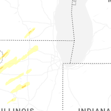
Illinois
| Local Time | Report Details |
|---|---|
| 5:05 PM CDT | Quarter sized hail reported near Coal Valley, IL, 68.3 miles NW of Peoria, IL |
| 5:09 PM CDT | Quarter sized hail reported near Silvis, IL, 69.8 miles NW of Peoria, IL, report from mping: quarter (1.00 in.). |
| 5:09 PM CDT | Quarter sized hail reported near Silvis, IL, 70.9 miles NW of Peoria, IL, time estimated from radar. |
| 5:09 PM CDT | Quarter sized hail reported near Coal Valley, IL, 68.8 miles NW of Peoria, IL |
| 5:10 PM CDT | Quarter sized hail reported near Moline, IL, 70.1 miles ESE of Cedar Rapids, IA, report from mping: quarter (1.00 in.). |
| 5:20 PM CDT | Quarter sized hail reported near Hillsdale, IL, 68.9 miles NNW of Peoria, IL |
| 5:37 PM CDT | Tea Cup sized hail reported near Thomson, IL, 80.5 miles E of Cedar Rapids, IA, pictures of hail ranging in size from 3.00 to 3.25 inches. the time of the event was estimated using radar. |
| 5:38 PM CDT | Golf Ball sized hail reported near Thomson, IL, 81 miles E of Cedar Rapids, IA |
| 5:48 PM CDT | Ping Pong Ball sized hail reported near Mount Carroll, IL, 73.7 miles SSW of Madison, WI, social media picture of quarter to ping pong size hail. relayed by media. |
| 5:54 PM CDT | Storm damage reported in whiteside county IL, 69.3 miles NNW of Peoria, IL |
| 5:57 PM CDT | Large tree down... other trees stripped of bark. time estimated from rada in carroll county IL, 78.1 miles SSW of Madison, WI |
| 6:11 PM CDT | Sheriff reports downed power poles and power lines... and a barn destroyed... on mound hill road near pilgrim road in lee county. time estimate in ogle county IL, 81.8 miles S of Madison, WI |
| 6:11 PM CDT | Media showed video of trees down and a barn collapsed along mound hill rd. time estimated from radar. this lsr is likely a repeat but with a more precise locatio in lee county IL, 80.6 miles N of Peoria, IL |
| 6:13 PM CDT | A few trees reported down west of mount carrol in carroll county IL, 75.6 miles SSW of Madison, WI |
| 6:17 PM CDT | Debris reported in fields along rt 26 just south of woosung. time estimate in lee county IL, 81.3 miles S of Madison, WI |
| 6:19 PM CDT | Structure damage at a business along hwy 26 south of woosung. time estimate in lee county IL, 81.3 miles S of Madison, WI |
| 6:20 PM CDT | Ping Pong Ball sized hail reported near Rock Falls, IL, 72 miles N of Peoria, IL |
| 6:20 PM CDT | Powerlines blown down in rural yates cit in knox county IL, 23 miles WNW of Peoria, IL |
| 6:23 PM CDT | Reports of trees down and damage to outbuildings near w. edgewood rd and s. ridge rd in ogle county. time estimate in ogle county IL, 80.3 miles S of Madison, WI |
| 6:24 PM CDT | Storm damage reported in peoria county IL, 21 miles WNW of Peoria, IL |
| 6:25 PM CDT | Estimated 60-70 mph gust in lee county IL, 79.4 miles N of Peoria, IL |
| 6:28 PM CDT | Powerpoles blown down on elmore road at highway 15 in peoria county IL, 23.8 miles NW of Peoria, IL |
| 6:30 PM CDT | Small 2-inch limbs coming dow in ogle county IL, 73.4 miles S of Madison, WI |
| 6:31 PM CDT | 60 to 65 mph winds with pea to dime size hail covering the ground at main and vernon stree in fulton county IL, 22.2 miles W of Peoria, IL |
| 6:33 PM CDT | Powerlines blown down on mc clellan roa in peoria county IL, 20.7 miles WNW of Peoria, IL |
| 6:37 PM CDT | Quarter sized hail reported near Dixon, IL, 79.4 miles N of Peoria, IL, nickel to quarter sized hail. |
| 6:44 PM CDT | Trees and power lines down on hwy 251 between big mound rd and holcomb rd. grain bin destroye in ogle county IL, 71 miles SSE of Madison, WI |
| 6:46 PM CDT | Grain elevator down on train tracks. trees and power lines also down in the area. time estimated from rada in ogle county IL, 71.5 miles SSE of Madison, WI |
| 6:50 PM CDT | Roof or other structural material on road. also downed tree at farm just east of i-39. reported by retired nws employee. time estimated from rada in ogle county IL, 69.7 miles SSE of Madison, WI |
| 7:03 PM CDT | Storm damage reported in putnam county IL, 41.4 miles NNE of Peoria, IL |
| 7:04 PM CDT | Quarter sized hail reported near Rochelle, IL, 72.4 miles SSE of Madison, WI, quarter sized hail ongoing at e lindenwood rd and il-251. has been nearly continuous for several minutes. |
| 7:08 PM CDT | Powerlines blown down south of dunla in peoria county IL, 10.1 miles NNW of Peoria, IL |
| 7:09 PM CDT | Putnam county ema reports a power line down in hennepin. time estimated by rada in putnam county IL, 43.8 miles NNE of Peoria, IL |
| 7:22 PM CDT | Quarter sized hail reported near Utica, IL, 55.1 miles NNE of Peoria, IL, report from mping: quarter (1.00 in.). |
| 7:27 PM CDT | Quarter sized hail reported near Chillicothe, IL, 13.8 miles NNE of Peoria, IL, quarter size hail with 60 mph thunderstorm wind gusts. |
| 7:27 PM CDT | 60 mph wind gust with 1 inch hai in peoria county IL, 13.8 miles NNE of Peoria, IL |
| 7:30 PM CDT | Ping Pong Ball sized hail reported near Manito, IL, 16.3 miles SSW of Peoria, IL, measured with photo. |
| 7:35 PM CDT | Quarter sized hail reported near Mapleton, IL, 11.3 miles SW of Peoria, IL, quarter size hail off of highway 24 in mapleton. photo via social media. |
| 7:42 PM CDT | Measured at an ambient personal weather statio in la salle county IL, 57.8 miles WSW of Chicago, IL |
| 8:11 PM CDT | Eight-inch tree branch dow in dupage county IL, 27.2 miles W of Chicago, IL |
| 8:31 PM CDT | Measured at the midway aso in cook county IL, 9.4 miles SW of Chicago, IL |
| 8:32 PM CDT | Measured at pws kilchica78 in cook county IL, 2.7 miles WNW of Chicago, IL |
| 8:40 PM CDT | Measured at the harrison dever cri in lmz741 county IL, 4.1 miles NE of Chicago, IL |
| 10:20 PM CDT | Estimated 60+ mph winds at nws offic in will county IL, 30.3 miles SW of Chicago, IL |
| 10:46 PM CDT | Downed power poles. time estimated based on rada in will county IL, 34.9 miles SW of Chicago, IL |
Louisiana
| Local Time | Report Details |
|---|---|
| 5:40 PM CDT | Thunderstorm winds downed an oak tree onto a powerline along north oller road near tickfa in tangipahoa county LA, 51.2 miles NNW of New Orleans, LA |
Indiana
| Local Time | Report Details |
|---|---|
| 7:14 PM EDT | Large tree uprooted. time estimated from rada in vigo county IN, 51.8 miles E of Mattoon, IL |
| 7:30 PM EDT | Roof off of a barn. time estimated by rada in cass county IN, 77.5 miles W of Fort Wayne, IN |
| 7:30 PM EDT | T-storm winds damaged small barn and large shed on mansfield road...damaged a garage in bridgeton...with a couple trees downed onto houses and in-59 closed from downed in parke county IN, 53.8 miles W of Indianapolis, IN |
| 7:34 PM EDT | Update to previous report. t-storm winds picked up and blew grain bin across road at in-59 and ferndale road...and downed power lines and 20-30 trees along us-36 near r in parke county IN, 50.7 miles W of Indianapolis, IN |
| 7:36 PM EDT | Up to 30 trees down. time estimated from rada in parke county IN, 51.1 miles W of Indianapolis, IN |
| 7:49 PM EDT | Emergency manager reported large tree downed across the road due to thunderstorm winds near inwood in marshall county indian in marshall county IN, 59.2 miles WNW of Fort Wayne, IN |
| 7:58 PM EDT | Tree downed by t-storm winds. time estimated by rada in putnam county IN, 29.3 miles WNW of Indianapolis, IN |
| 7:59 PM EDT | Recorded with an anemomete in kosciusko county IN, 49.6 miles W of Fort Wayne, IN |
| 8:10 PM EDT | Tree downed by t-storm winds. time estimated from rada in boone county IN, 34.4 miles NW of Indianapolis, IN |
| 8:17 PM EDT | Tree downed by t-storm winds. time estimated from rada in clinton county IN, 49.6 miles NNW of Indianapolis, IN |
| 8:28 PM EDT | Tree downed on county road 700 north by t-storm winds. time estimated from rada in boone county IN, 26.4 miles NNW of Indianapolis, IN |
| 9:54 PM EDT | Asos station kfwa fort wayne international a in allen county IN, 7.8 miles SSW of Fort Wayne, IN |
Wisconsin
| Local Time | Report Details |
|---|---|
| 6:25 PM CDT | Tree down reported by lafayette county dispatchers. time estimated by rada in lafayette county WI, 39.5 miles SW of Madison, WI |
| 6:57 PM CDT | Jefferson county dispatch reports tree down on power line north of palmyr in jefferson county WI, 40.9 miles ESE of Madison, WI |
| 7:02 PM CDT | Quarter sized hail reported near Whitewater, WI, 35.9 miles ESE of Madison, WI, report from mping: quarter (1.00 in.). |
| 7:04 PM CDT | Tree down by gibbs lake reported by rock county dispatchers. time estimated by rada in rock county WI, 22.2 miles SSE of Madison, WI |
| 7:07 PM CDT | Half Dollar sized hail reported near Horicon, WI, 45.8 miles NE of Madison, WI, facebook report of measured hail 1.25 inch with photo. |
| 7:19 PM CDT | Walworth county dispatch reports trees and powerlines down on northwest side of county as well as near whitewater. time estimated by rada in walworth county WI, 36.8 miles ESE of Madison, WI |
| 7:31 PM CDT | Walworth county dispatch reports trees down in sugar creek township. time estimated by rada in walworth county WI, 49.6 miles ESE of Madison, WI |
| 7:44 PM CDT | Waukesha county dispatch reports a tree on a phone in line butler. time estimated by rada in waukesha county WI, 66.7 miles E of Madison, WI |
| 7:47 PM CDT | Waukesha county dispatch reports tree on a power line in new berlin. time estimated by rada in waukesha county WI, 65 miles E of Madison, WI |
| 8:05 PM CDT | Fox6 milwaukee reports damage to trees and powerlines with 45th street blocked. time estimated by rada in kenosha county WI, 50.7 miles NNW of Chicago, IL |
| 8:10 PM CDT | Social media reports of multiple trees and power lines down in northern kenosha... with tree limbs on roofs as well. siding missing from multiple houses (via photo repo in kenosha county WI, 50.5 miles NNW of Chicago, IL |
Connect with Interactive Hail Maps