

Hail Map for Monday, June 22, 2026

Number of Impacted Households on 6/22/2026
0
Impacted by 1" or Larger Hail
0
Impacted by 1.75" or Larger Hail
0
Impacted by 2.5" or Larger Hail
Square Miles of Populated Area Impacted on 6/22/2026
0
Impacted by 1" or Larger Hail
0
Impacted by 1.75" or Larger Hail
0
Impacted by 2.5" or Larger Hail
Cities Most Affected by Hail Storms of 6/22/2026
| Hail Size | Demographics of Zip Codes Affected | ||||||
|---|---|---|---|---|---|---|---|
| City | Count | Average | Largest | Pop Density | House Value | Income | Age |
| Kimball, NE | 1 | 1.75 | 1.75 | 7 | $54k | $30.6k | 45.6 |
Hail and Wind Damage Spotted on 6/22/2026
Filter by Report Type:Hail ReportsWind Reports
States Impacted
Arkansas, West Virginia, Mississippi, Pennsylvania, New Jersey, Wyoming, Alabama, Virginia, Tennessee, NebraskaArkansas
| Local Time | Report Details |
|---|---|
| 7:00 AM CDT | A tree down on a house near this location in lama in johnson county AR, 57.2 miles E of Fort Smith, AR |
| 7:09 AM CDT | A report of a tree down on a house in the community of haskell near this locatio in saline county AR, 26.5 miles SW of Little Rock, AR |
| 7:10 AM CDT | Reports of multiple power lines down in russellvill in pope county AR, 59.9 miles NW of Little Rock, AR |
| 7:25 AM CDT | Multiple power outages reported in the vicinity of tyndall park area of bento in saline county AR, 21.7 miles SW of Little Rock, AR |
| 7:26 AM CDT | Reports of a tree blown down on a house near the 1900 block of highway 113... west of morrilton. there were also other trees down in the are in conway county AR, 39.9 miles NW of Little Rock, AR |
| 7:57 AM CDT | A tree blown down blocking southbound lanes of i-530 near white hal in jefferson county AR, 34.3 miles SSE of Little Rock, AR |
| 8:02 AM CDT | A power line was blown down and caught fire along west 24th ave in pine bluf in jefferson county AR, 40.5 miles SSE of Little Rock, AR |
| 8:03 AM CDT | A tree was blown down at the intersection of highway 79 and island harbor marina road in white hal in jefferson county AR, 35.9 miles SSE of Little Rock, AR |
West Virginia
| Local Time | Report Details |
|---|---|
| 10:32 AM EDT | Tree down on big sandy river road near underpass blocking half the roadway. time estimated from rada in wayne county WV, 51.7 miles W of Charleston, WV |
| 10:45 AM EDT | Trees and power lines down across garretts creek road at cloverleaf lane. time estimated from rada in wayne county WV, 45.3 miles W of Charleston, WV |
| 1:24 PM EDT | Tree down blocking sandy huff road. time estimated from rada in mcdowell county WV, 59.8 miles S of Charleston, WV |
| 1:51 PM EDT | Tree blocking coal river road between horse creek road and peachtree road. time estimated from rada in raleigh county WV, 34.1 miles SSE of Charleston, WV |
| 2:55 PM EDT | Tree down blocking edray road in slippery hill. time estimated from rada in pocahontas county WV, 43.7 miles SSW of Elkins, WV |
| 3:04 PM EDT | Tree down. wire and power pole also on ground. road is blocke in greenbrier county WV, 39.6 miles NW of Roanoke, VA |
| 3:17 PM EDT | Tree and power line dow in greenbrier county WV, 44.6 miles NNW of Roanoke, VA |
Mississippi
| Local Time | Report Details |
|---|---|
| 10:50 AM CDT | Lines down and power ou in sunflower county MS, 100.8 miles NNW of Jackson, MS |
| 12:00 PM CDT | Lines down and multiple areas of power outage in hinds county MS, 5 miles NNW of Jackson, MS |
| 12:43 PM CDT | Tree down on old hwy 2 in warren county MS, 37.5 miles W of Jackson, MS |
| 1:00 PM CDT | Line down and power outage in madison county MS, 22.9 miles N of Jackson, MS |
| 1:00 PM CDT | Tree down in tow in attala county MS, 53 miles WSW of Starkville, MS |
| 1:03 PM CDT | Tree down along hwy 35 in attala county MS, 53.5 miles SW of Starkville, MS |
| 1:18 PM CDT | Tree down along hwy 48 in newton county MS, 53.2 miles E of Jackson, MS |
| 1:28 PM CDT | Tree dow in newton county MS, 55.1 miles E of Jackson, MS |
| 1:42 PM CDT | Tree and lines down on hight moore r in winston county MS, 37.7 miles SSW of Starkville, MS |
Pennsylvania
| Local Time | Report Details |
|---|---|
| 2:24 PM EDT | Multiple large tree branches and a tree snapped. time estimated from rada in philadelphia county PA, 71 miles SW of Brooklyn, NY |
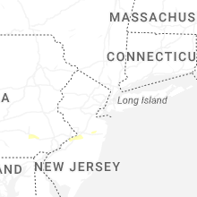
New Jersey
| Local Time | Report Details |
|---|---|
| 2:48 PM EDT | Half Dollar sized hail reported near Burlington, NJ, 60.5 miles SW of Brooklyn, NY, trained spotter reports a lot of pea sized hail... but a few hailstones up to half dollar sized. time estimated from radar. |
| 2:48 PM EDT | Quarter sized hail reported near Burlington, NJ, 60.5 miles SW of Brooklyn, NY, a trained spotter shared a photo of quarter sized hail. time estimated from radar. |
| 2:48 PM EDT | Ping Pong Ball sized hail reported near Burlington, NJ, 60 miles SW of Brooklyn, NY, 2 minutes of hail up to 1.5 inch diameter. time estimated from radar. |
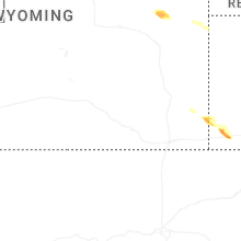
Wyoming
| Local Time | Report Details |
|---|---|
| 1:39 PM MDT | Quarter sized hail reported near Albin, WY, 34.7 miles SW of Scottsbluff, NE |
Alabama
| Local Time | Report Details |
|---|---|
| 2:40 PM CDT | Trees down on power line on cr 49 in jackson county AL, 21.5 miles WSW of Chattanooga, TN |
| 2:54 PM CDT | Trees down on power lines on county road 77 at guffey roa in jackson county AL, 57.5 miles SW of Chattanooga, TN |
| 2:54 PM CDT | Tree down on county road 78 at cr 34 in jackson county AL, 33.7 miles SW of Chattanooga, TN |
| 8:03 PM UTC | Tree down on the road near county road 50 and 51. time estimated from rada in lauderdale county AL, 21.6 miles ENE of Florence, AL |
Virginia
| Local Time | Report Details |
|---|---|
| 7:49 PM UTC | Trees down on mill creek road in page county VA, 75.9 miles ESE of Elkins, WV |
Tennessee
| Local Time | Report Details |
|---|---|
| 3:57 PM EDT | Tree(s) reported down on campbell st. timing based on rada in hamilton county TN, 4.3 miles ENE of Chattanooga, TN |
Nebraska
| Local Time | Report Details |
|---|---|
| 8:24 PM UTC | Golf Ball sized hail reported near Kimball, NE, 39 miles S of Scottsbluff, NE |
Connect with Interactive Hail Maps