

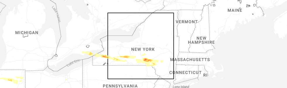
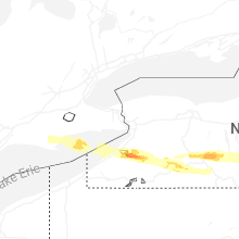
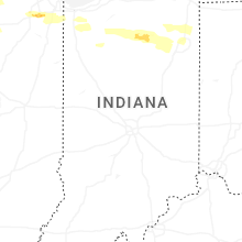
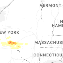
Hail Map for Tuesday, March 31, 2026
Number of Impacted Households on 3/31/2026
0
Impacted by 1" or Larger Hail
0
Impacted by 1.75" or Larger Hail
0
Impacted by 2.5" or Larger Hail
Square Miles of Populated Area Impacted on 3/31/2026
0
Impacted by 1" or Larger Hail
0
Impacted by 1.75" or Larger Hail
0
Impacted by 2.5" or Larger Hail
Cities Most Affected by Hail Storms of 3/31/2026
| Hail Size | Demographics of Zip Codes Affected | ||||||
|---|---|---|---|---|---|---|---|
| City | Count | Average | Largest | Pop Density | House Value | Income | Age |
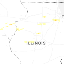
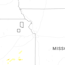
| Joliet, IL | 2 | 1.75 | 1.75 | 1255 | $87k | $38.5k | 33.0 |
| Letts, IA | 1 | 1.75 | 1.75 | 15 | $83k | $46.2k | 45.8 |
| Wayland, IA | 1 | 1.75 | 1.75 | 26 | $68k | $36.4k | 44.6 |
| Easton, IL | 1 | 1.75 | 1.75 | 5 | $56k | $29.7k | 46.7 |
| New Lenox, IL | 1 | 1.75 | 1.75 | 1361 | $176k | $70.7k | 37.6 |
| Washington, IA | 1 | 1.75 | 1.75 | 59 | $81k | $38.7k | 42.5 |
| Guthrie, TX | 1 | 1.75 | 1.75 | 0 | $14k | $41.5k | 43.6 |
| Greene, NY | 1 | 1.75 | 1.75 | 59 | $74k | $37.5k | 43.9 |
| Childress, TX | 1 | 1.75 | 1.75 | 7 | $45k | $27.5k | 33.8 |
Hail and Wind Damage Spotted on 3/31/2026
Filter by Report Type:Hail ReportsWind Reports
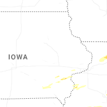
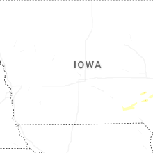
States Impacted
Iowa, Illinois, Wisconsin, New York, Ohio, Indiana, Pennsylvania, Texas, Mississippi, Massachusetts, KansasIowa
| Local Time | Report Details |
|---|---|
| 7:15 AM CDT | Quarter sized hail reported near Wayland, IA, 50.4 miles N of Kahoka, MO, estimate of quarter-sized to ping pong ball-sized hail. |
| 7:16 AM CDT | Quarter sized hail reported near Wayland, IA, 50.4 miles N of Kahoka, MO |
| 7:18 AM CDT | Golf Ball sized hail reported near Wayland, IA, 50.4 miles N of Kahoka, MO, via social media. |
| 8:14 AM CDT | Golf Ball sized hail reported near Letts, IA, 50.2 miles SSE of Cedar Rapids, IA, via social media... delayed report. |
| 9:29 AM CDT | Golf Ball sized hail reported near Washington, IA, 43.9 miles S of Cedar Rapids, IA |
| 10:23 AM CDT | Ping Pong Ball sized hail reported near Columbus Junction, IA, 51.7 miles SSE of Cedar Rapids, IA, via social media. |
| 10:39 AM CDT | Quarter sized hail reported near Letts, IA, 52.1 miles SSE of Cedar Rapids, IA |
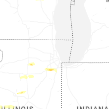
Illinois
| Local Time | Report Details |
|---|---|
| 7:30 AM CDT | Quarter sized hail reported near Little York, IL, 60.1 miles NE of Kahoka, MO |
| 7:40 AM CDT | Half Dollar sized hail reported near Oquawka, IL, 54 miles NE of Kahoka, MO, passed along by broadcast media. |
| 8:29 AM CDT | Quarter sized hail reported near Sandwich, IL, 53.8 miles WSW of Chicago, IL, time estimated from radar. |
| 9:12 AM CDT | Quarter sized hail reported near Washington, IL, 7.7 miles ENE of Peoria, IL, nickel to quarter size. |
| 9:17 AM CDT | Ping Pong Ball sized hail reported near Washington, IL, 6.5 miles ENE of Peoria, IL |
| 9:18 AM CDT | Quarter sized hail reported near Joliet, IL, 38.8 miles SW of Chicago, IL, multiple trained spotter reports of dime to quarter size hail at and near joliet junior college. |
| 9:21 AM CDT | Quarter sized hail reported near Joliet, IL, 37.1 miles SW of Chicago, IL, report from mping. |
| 9:21 AM CDT | Golf Ball sized hail reported near Joliet, IL, 35.7 miles SW of Chicago, IL, photo shared on social media showing several large hailstones at moen avenue and midland avenue in rockdale. the largest hailstones were approximately golf ball size. t |
| 9:24 AM CDT | Quarter sized hail reported near Joliet, IL, 35.7 miles SW of Chicago, IL, photo shared of hail in preston heights. the largest hailstones were approximately quarter size. time estimated from radar. |
| 9:27 AM CDT | Golf Ball sized hail reported near Easton, IL, 34.3 miles SSW of Peoria, IL |
| 9:27 AM CDT | Golf Ball sized hail reported near Joliet, IL, 33.6 miles SW of Chicago, IL |
| 9:28 AM CDT | Quarter sized hail reported near Joliet, IL, 33.3 miles SW of Chicago, IL, report from mping. |
| 9:29 AM CDT | Half Dollar sized hail reported near Joliet, IL, 34.3 miles SW of Chicago, IL, report from mping. |
| 9:33 AM CDT | Half Dollar sized hail reported near Washington, IL, 12.6 miles E of Peoria, IL, east cruger & deemack road. delayed report. time estimated from radar. |
| 9:34 AM CDT | Golf Ball sized hail reported near New Lenox, IL, 31.2 miles SW of Chicago, IL, multiple public reports of quarter to golf ball size hail in new lenox. time estimated from radar. |
| 9:34 AM CDT | Ping Pong Ball sized hail reported near Joliet, IL, 36.2 miles SW of Chicago, IL, photo shared of approximately ping pong ball size hail at route 53 and laraway road. time estimated from radar. |
| 9:35 AM CDT | Quarter sized hail reported near New Lenox, IL, 31.7 miles SSW of Chicago, IL, report from mping. |
| 9:37 AM CDT | Quarter sized hail reported near New Lenox, IL, 31.2 miles SSW of Chicago, IL, report from mping. |
| 9:40 AM CDT | Quarter sized hail reported near Eureka, IL, 17 miles ENE of Peoria, IL |
| 9:44 AM CDT | Half Dollar sized hail reported near Eureka, IL, 16.8 miles E of Peoria, IL |
| 10:16 AM CDT | Ping Pong Ball sized hail reported near Polo, IL, 76.1 miles S of Madison, WI, largest hailstone was measured to be 1.5 inches in diameter. most hail was approximately half an inch in diameter. time estimated from radar. |
| 10:31 AM CDT | Quarter sized hail reported near Mount Morris, IL, 70.7 miles S of Madison, WI |
| 2:14 PM CDT | Quarter sized hail reported near Orion, IL, 64.5 miles NW of Peoria, IL, report relayed by broadcast media. |
| 6:55 PM CDT | Awos station k3lf litchfield municipal airpor in montgomery county IL, 47.1 miles NE of Saint Louis, MO |
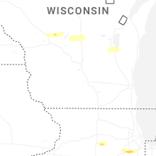
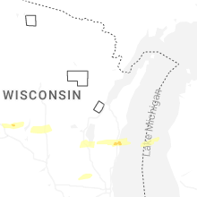
Wisconsin
| Local Time | Report Details |
|---|---|
| 8:43 AM CDT | Quarter sized hail reported near Princeton, WI, 55.3 miles NNE of Madison, WI, report from mping: quarter (1.00 in.). |
| 10:27 AM CDT | Quarter sized hail reported near Sheboygan, WI, 50.3 miles SSE of Green Bay, WI, picture of quarter sized hail in the town of mosel. |
| 10:42 AM CDT | Half Dollar sized hail reported near Sheboygan Falls, WI, 49.3 miles S of Green Bay, WI, report from mping: half dollar (1.25 in.). |
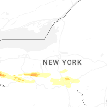
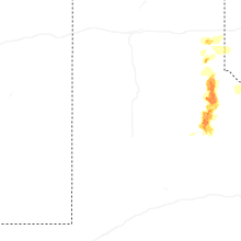
New York
| Local Time | Report Details |
|---|---|
| 3:09 PM EDT | Half Dollar sized hail reported near Perrysburg, NY, 30 miles SSW of Buffalo, NY, updating previous report from perrysburg. half dollar size hail. cars dented. holes in siding due to wind driven hail. large accumulations of hail making roads slushy. |
| 3:09 PM EDT | Quarter sized hail reported near Perrysburg, NY, 30 miles SSW of Buffalo, NY, wind driven hail. large accumulations of hail making roads slushy. |
| 3:14 PM EDT | Report from facebook of tree falling on a house. time estimated based on rada in cattaraugus county NY, 29.5 miles S of Buffalo, NY |
| 3:17 PM EDT | Ping Pong Ball sized hail reported near Collins, NY, 26.7 miles S of Buffalo, NY, received report with photo via facebook. |
| 3:17 PM EDT | Ping Pong Ball sized hail reported near Gowanda, NY, 29.5 miles S of Buffalo, NY, received report with photo. |
| 3:34 PM EDT | Quarter sized hail reported near Springville, NY, 30.9 miles SSE of Buffalo, NY, received report on facebook of accumulating hail on route 219 just south of cattaraugus creek. time estimated based on radar. |
| 3:40 PM EDT | Multiple trees and powerlines down near ashford hollow roa in cattaraugus county NY, 35.5 miles SSE of Buffalo, NY |
| 3:40 PM EDT | Quarter sized hail reported near West Valley, NY, 35.5 miles SSE of Buffalo, NY |
| 4:26 PM EDT | Quarter sized hail reported near Avoca, NY, 78.5 miles WSW of Syracuse, NY |
| 6:36 PM EDT | Golf Ball sized hail reported near Greene, NY, 53.3 miles SSE of Syracuse, NY |
| 6:45 PM EDT | Multiple trees and wires down in the vicinity of broome county landfil in broome county NY, 56.5 miles S of Syracuse, NY |
| 6:58 PM EDT | Quarter sized hail reported near Binghamton, NY, 55.4 miles N of Scranton, PA |
| 7:00 PM EDT | Quarter sized hail reported near Binghamton, NY, 55 miles NNW of Scranton, PA |
| 7:01 PM EDT | Half Dollar sized hail reported near Afton, NY, 57 miles N of Scranton, PA |
| 7:04 PM EDT | Ping Pong Ball sized hail reported near Bainbridge, NY, 61.9 miles SSE of Syracuse, NY |
| 7:25 PM EDT | Nys mesonet station fred fredoni in chautauqua county NY, 40.7 miles SW of Buffalo, NY |
| 7:30 PM EDT | Asos station kdkk dunkirk airpor in chautauqua county NY, 33.6 miles SW of Buffalo, NY |
| 7:35 PM EDT | Tree and wires down on roa in delaware county NY, 46.5 miles NNE of Scranton, PA |
| 8:02 PM EDT | Report of a single tree down on route 9j in stuyvesant. time estimated from rada in columbia county NY, 30.3 miles SSE of Schenectady, NY |
| 8:12 PM EDT | Tree down on roa in delaware county NY, 57.5 miles NE of Scranton, PA |
| 8:28 PM EDT | Multiple trees down on gooding rd near crump hill rd and rte 42 in the town of shandaken. time estimated from rada in ulster county NY, 51.6 miles SSW of Schenectady, NY |
| 8:58 PM EDT | Tree downed across new york route 9j. the road was closed between stuyvesant falls road and day roa in columbia county NY, 33.9 miles SSE of Schenectady, NY |
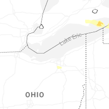
Ohio
| Local Time | Report Details |
|---|---|
| 3:38 PM EDT | Semi truck flipped over on us-24 near hertzfeld rd. time estimated via rada in lucas county OH, 73.1 miles ENE of Fort Wayne, IN |
| 3:39 PM EDT | Tree and powerlines down on roachton rd. time estimated via rada in wood county OH, 84.3 miles ENE of Fort Wayne, IN |
| 3:47 PM EDT | K1g0 reports 51 knot wind gus in wood county OH, 79.5 miles ENE of Fort Wayne, IN |
| 4:04 PM EDT | 66 mph wind gust measured on personal weather statio in ottawa county OH, 85.6 miles W of Cleveland, OH |
| 4:17 PM EDT | Multiple power poles down near buchanan rd and oak dr. time estimated via rada in sandusky county OH, 74.8 miles W of Cleveland, OH |
| 4:33 PM EDT | Mesonet station xsdb 2 nne sandusk in lez144 county OH, 52.4 miles W of Cleveland, OH |
| 4:47 PM EDT | Social media report of trees down... power poles down... and outdoor playset tossed on state route 4... south of attica. time estimated via rada in seneca county OH, 71.4 miles WSW of Cleveland, OH |
| 4:53 PM EDT | Power lines and poles down in collins. time estimated via rada in huron county OH, 45.6 miles WSW of Cleveland, OH |
| 5:04 PM EDT | Tree down across north main stree in lorain county OH, 28.8 miles WSW of Cleveland, OH |
| 5:04 PM EDT | Very large tree down on a house on north main street. time estimated via rada in lorain county OH, 28.9 miles WSW of Cleveland, OH |
| 5:09 PM EDT | Asos station klpr lorain elyri in lorain county OH, 27.6 miles WSW of Cleveland, OH |
| 5:14 PM EDT | Trained weather spotter reports 74 mph gust on personal weather statio in lorain county OH, 18.8 miles WSW of Cleveland, OH |
| 5:18 PM EDT | 3 very large trees down near the intersection of canterbury and detroit road in cuyahoga county OH, 11.6 miles WSW of Cleveland, OH |
| 5:24 PM EDT | Asos station kcle clevelan in cuyahoga county OH, 10.1 miles SW of Cleveland, OH |
| 5:26 PM EDT | Social media report of a large tree downed in cleveland. time estimated via rada in cuyahoga county OH, 4.6 miles SSW of Cleveland, OH |
| 5:28 PM EDT | Tree uproote in cuyahoga county OH, 5.4 miles SSW of Cleveland, OH |
| 5:29 PM EDT | Mesonet station xcle cleveland - edgewate in lez146 county OH, 2.1 miles W of Cleveland, OH |
| 5:30 PM EDT | Large portion of roof came off an apartment building on fulton roa in cuyahoga county OH, 4.1 miles SSW of Cleveland, OH |
| 5:31 PM EDT | Windows of a high rise office building at east 9th st and st. clair ave blown out due to thunderstorm wind gust in cuyahoga county OH, 0.3 miles S of Cleveland, OH |
| 5:32 PM EDT | Asos station kbkl clevelan in cuyahoga county OH, 1.2 miles NNE of Cleveland, OH |
| 5:36 PM EDT | Buoy station cndo1 cleveland... o in lez146 county OH, 3.6 miles NE of Cleveland, OH |
| 5:42 PM EDT | Buoy station faio1 fairport... o in lake county OH, 27.6 miles NE of Cleveland, OH |
| 5:44 PM EDT | Large tree down on beachwood driv in lake county OH, 17.9 miles ENE of Cleveland, OH |
| 5:45 PM EDT | Awos station kcg in cuyahoga county OH, 12.3 miles ENE of Cleveland, OH |
| 5:50 PM EDT | Wires down on roa in geauga county OH, 20.3 miles ESE of Cleveland, OH |
| 5:52 PM EDT | Trees and powerlines down on hopkins roa in lake county OH, 22.6 miles NE of Cleveland, OH |
| 5:55 PM EDT | 65 mph gust and dime size hai in geauga county OH, 26 miles E of Cleveland, OH |
| 6:18 PM EDT | Asos station khzy ashtabul in ashtabula county OH, 54.7 miles ENE of Cleveland, OH |
| 6:19 PM EDT | Mesonet station xcon conneaut ligh in lez149 county OH, 67 miles ENE of Cleveland, OH |
| 6:46 PM EDT | Part of roof torn off of southeast high schoo in portage county OH, 41.9 miles SE of Cleveland, OH |
| 7:03 PM EDT | Dispatch reports roof blown off and barn blown dow in defiance county OH, 21 miles NE of Fort Wayne, IN |
| 7:10 PM EDT | Corrects previous report from 3 se hicksville. mesonet station dvi11214 hicksvill in defiance county OH, 23.1 miles ENE of Fort Wayne, IN |
| 7:10 PM EDT | Corrects previous report from 3 se hicksville. mesonet station dvi11214 hicksvill in defiance county OH, 23.1 miles ENE of Fort Wayne, IN |
| 7:10 PM EDT | Photo relayed by broadcast media of metal roofing thrown into a nearby field in hicksville. time estimated via rada in defiance county OH, 23.1 miles NE of Fort Wayne, IN |
| 7:12 PM EDT | Barn damaged near jericho and roselawn roads. time estimated via rada in defiance county OH, 25.2 miles ENE of Fort Wayne, IN |
| 7:20 PM EDT | Tree down on sr 127. time estimated via rada in defiance county OH, 30.1 miles ENE of Fort Wayne, IN |
| 7:22 PM EDT | Multiple power poles and lines down in sherwood. time estimated via rada in defiance county OH, 31.8 miles ENE of Fort Wayne, IN |
| 7:22 PM EDT | A grain bin was destroyed on fountain street west of us 127 in sherwood. time estimated via rada in defiance county OH, 31 miles ENE of Fort Wayne, IN |
| 7:23 PM EDT | Dispatch reports roof blown of in defiance county OH, 43.3 miles ENE of Fort Wayne, IN |
| 7:24 PM EDT | Trees down at sr 127 and sr 18. time estimated via rada in defiance county OH, 32.5 miles ENE of Fort Wayne, IN |
| 7:25 PM EDT | Large tree uprooted onto home at the intersection of cromley rd and sr 111. time estimated via rada in defiance county OH, 36.3 miles ENE of Fort Wayne, IN |
| 7:26 PM EDT | Power poles down on dutch-john road east of scott. reported by van wert county emergency manage in paulding county OH, 27.2 miles ESE of Fort Wayne, IN |
| 7:26 PM EDT | Several reports of powerlines down in and around scott. time estimated via rada in van wert county OH, 27.8 miles ESE of Fort Wayne, IN |
| 7:27 PM EDT | Very large tree fell onto car in defiance. unknown if any injuries. time estimated via rada in defiance county OH, 41 miles ENE of Fort Wayne, IN |
| 7:28 PM EDT | Dispatch reports roof blown off in independence. time estimated via rada in defiance county OH, 44.4 miles ENE of Fort Wayne, IN |
| 7:38 PM EDT | Tree down at sr 18 and township rd 15. time estimated via rada in henry county OH, 50.9 miles ENE of Fort Wayne, IN |
| 7:50 PM EDT | Power lines downe in putnam county OH, 48.2 miles ESE of Fort Wayne, IN |
| 7:54 PM EDT | Healthy pine tree snappe in wood county OH, 69.3 miles E of Fort Wayne, IN |
| 8:34 PM EDT | Quarter sized hail reported near Brunswick, OH, 19.3 miles SSW of Cleveland, OH, report from mping: quarter (1.00 in.). |
| 8:34 PM EDT | Quarter sized hail reported near Brunswick, OH, 19.6 miles SSW of Cleveland, OH, social media photo of hail as big as one inch in brunswick. time estimated via radar. |
| 8:49 PM EDT | Ema relayed a report of up to 27 transmission lines down on sr 4 south of carrothers in northern crawford county. time estimated via rada in crawford county OH, 71 miles N of Columbus, OH |
| 8:53 PM EDT | Tree downed on leesville roa in crawford county OH, 57.9 miles N of Columbus, OH |
| 9:00 PM EDT | Social media report of a large tree down in stevens park. time estimated via rada in trumbull county OH, 54 miles ESE of Cleveland, OH |
| 9:20 PM EDT | Multiple trees and power-lines downed along route 430 east of mansfiel in richland county OH, 62.7 miles NNE of Columbus, OH |
| 9:25 PM EDT | Tree and power-lines down in luca in richland county OH, 59.5 miles NNE of Columbus, OH |
| 9:26 PM EDT | Tree downed in bellvill in richland county OH, 52.3 miles NNE of Columbus, OH |
| 9:45 PM EDT | Social media report for a large tree down in big prairi in holmes county OH, 61.2 miles SSW of Cleveland, OH |
| 9:56 PM EDT | Tree through a house on honeytown road. residents trapped in the basement. time estimated via rada in wayne county OH, 54.3 miles S of Cleveland, OH |
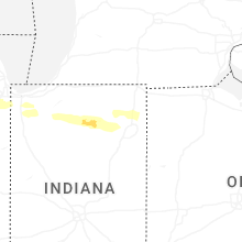
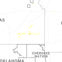
Indiana
| Local Time | Report Details |
|---|---|
| 5:50 PM EDT | Quarter sized hail reported near Claypool, IN, 40.9 miles W of Fort Wayne, IN, time estimated from radar. |
| 5:51 PM EDT | Tree downed near washington street and plymouth street. time estimated from rada in marshall county IN, 69.6 miles W of Fort Wayne, IN |
| 6:03 PM EDT | Dime size hail also reporte in marshall county IN, 53.4 miles W of Fort Wayne, IN |
| 6:05 PM EDT | Photo on facebook of a tree uprooted onto a house n sr 110 on the marshall and fulton county line. no injuries. time estimated via rada in fulton county IN, 63.5 miles W of Fort Wayne, IN |
| 6:10 PM EDT | Tree blown down and caused roof damage to a hous in kosciusko county IN, 49.6 miles W of Fort Wayne, IN |
| 6:17 PM EDT | Quarter sized hail reported near Mentone, IN, 45.8 miles W of Fort Wayne, IN |
| 6:18 PM EDT | Large tree snapped in mentone. time estimated via rada in kosciusko county IN, 49.5 miles W of Fort Wayne, IN |
| 6:18 PM EDT | Quarter sized hail reported near Mentone, IN, 49.5 miles W of Fort Wayne, IN |
| 6:18 PM EDT | Emergency manager relayed picture of a tree down that took out a portion of a home on north broadway street. unknown if any injuries. time estimated via rada in kosciusko county IN, 49.6 miles W of Fort Wayne, IN |
| 6:20 PM EDT | Quarter sized hail reported near Claypool, IN, 40.9 miles W of Fort Wayne, IN, corrects previous hail report from claypool. time estimated from radar. |
| 6:20 PM EDT | Picture on facebook of large tree branches down near beaver dam lake. public report also says a barn was damaged. time estimated via rada in kosciusko county IN, 45.5 miles W of Fort Wayne, IN |
| 6:20 PM EDT | Photo on facebook showing a roof torn off of a large animal barn north of akron near beaver dam. time estimated via rada in kosciusko county IN, 47 miles W of Fort Wayne, IN |
| 6:20 PM EDT | Photo on facebook of several large trees down and numerous other smaller limbs. time estimated via rada in kosciusko county IN, 46.5 miles W of Fort Wayne, IN |
| 6:21 PM EDT | Quarter sized hail reported near Claypool, IN, 44.4 miles W of Fort Wayne, IN, quarter size hail at palestine lake. time estimated via radar. |
| 6:24 PM EDT | Quarter sized hail reported near Warsaw, IN, 39.8 miles W of Fort Wayne, IN |
| 6:24 PM EDT | Half Dollar sized hail reported near Warsaw, IN, 40.6 miles WNW of Fort Wayne, IN, photo showing hail just larger than a quarter south of warsaw. time estimated via radar. |
| 6:24 PM EDT | Corrects time of previous tstm wnd dmg report from 1 nnw akron. roof damage to a home in akron. time estimated via rada in fulton county IN, 48.7 miles W of Fort Wayne, IN |
| 6:25 PM EDT | Quarter sized hail reported near Claypool, IN, 40.9 miles W of Fort Wayne, IN, photo on x shows hail up to quarter size in claypool. time estimated via radar. |
| 6:26 PM EDT | Tree downed 950 s between 500 and 600 w. time estimated from rada in kosciusko county IN, 43.9 miles W of Fort Wayne, IN |
| 6:26 PM EDT | Quarter sized hail reported near Silver Lake, IN, 40.8 miles W of Fort Wayne, IN, 1 inch hail on the south side of burket. time estimated via radar. |
| 6:26 PM EDT | Corrects time of previous tstm wnd dmg report from mentone. several trees down in mentone. time estimated via rada in kosciusko county IN, 49.5 miles W of Fort Wayne, IN |
| 6:28 PM EDT | Roof damage to home between akron and silver lake. time estimated via rada in kosciusko county IN, 45 miles W of Fort Wayne, IN |
| 6:30 PM EDT | Corrects time of previous tstm wnd dmg report from 3 nnw north manchester. photo on facebook of damage to a barn on packerton rd near north manchester. time estimated v in wabash county IN, 36.7 miles W of Fort Wayne, IN |
| 6:31 PM EDT | Corrects time of previous tstm wnd dmg report from north manchester. several large tree branches snapped in north manchester. time estimated via rada in wabash county IN, 35.3 miles W of Fort Wayne, IN |
| 6:50 PM EDT | Quarter sized hail reported near Fort Wayne, IN, 5.3 miles WNW of Fort Wayne, IN, report from mping: quarter (1.00 in.). |
| 6:53 PM EDT | Storm damage reported in allen county IN, 6.9 miles WNW of Fort Wayne, IN |
| 6:55 PM EDT | Storm damage reported in allen county IN, 3.2 miles NNE of Fort Wayne, IN |
| 6:59 PM EDT | Quarter sized hail reported near Fort Wayne, IN, 5.3 miles WNW of Fort Wayne, IN, report from mping: quarter (1.00 in.). |
| 7:24 PM EDT | Roof damage to a home in akron. time estimated via rada in fulton county IN, 48.7 miles W of Fort Wayne, IN |
| 7:30 PM EDT | Phot on facebook of damage to a barn on packerton rd near north manchester. time estimated via rada in wabash county IN, 36.7 miles W of Fort Wayne, IN |
| 7:31 PM EDT | Several large tree branches snapped in north manchester. time estimated via rada in wabash county IN, 35.3 miles W of Fort Wayne, IN |
| 8:26 PM EDT | Several trees down in mentone. time estimated via rada in kosciusko county IN, 49.5 miles W of Fort Wayne, IN |
Pennsylvania
| Local Time | Report Details |
|---|---|
| 6:32 PM EDT | Social media report of trees down in lake city. time estimated via rada in erie county PA, 77.9 miles ENE of Cleveland, OH |
| 6:35 PM EDT | Large pine tree down on hous in erie county PA, 75 miles ENE of Cleveland, OH |
| 6:46 PM EDT | Tree down on hous in erie county PA, 79.4 miles SW of Buffalo, NY |
| 6:55 PM EDT | Social media report and photos of several trees down in waterford. the corner of a roof was damaged on a hom in erie county PA, 86.2 miles SW of Buffalo, NY |
| 6:57 PM EDT | Tree dow in mercer county PA, 59 miles NNW of Pittsburgh, PA |
| 7:26 PM EDT | Tree dow in venango county PA, 76.7 miles N of Pittsburgh, PA |
| 7:28 PM EDT | Six trees reported dow in venango county PA, 81.9 miles NNE of Pittsburgh, PA |
| 7:34 PM EDT | Trees down across route 127 and campbell hill roa in warren county PA, 87.7 miles SSW of Buffalo, NY |
| 7:45 PM EDT | Wires were reported dow in lawrence county PA, 45.2 miles NNW of Pittsburgh, PA |
| 7:55 PM EDT | Trees and wires down across six mile roa in warren county PA, 79 miles S of Buffalo, NY |
| 7:56 PM EDT | Trees down across cherry grove roa in warren county PA, 78.4 miles S of Buffalo, NY |
| 8:06 PM EDT | Downed trees blocking minard run roa in mckean county PA, 68.3 miles S of Buffalo, NY |
| 8:24 PM EDT | Trees and wires down across route 5 in mckean county PA, 76.8 miles SSE of Buffalo, NY |
| 8:37 PM EDT | Large trees on wire in mercer county PA, 60.9 miles NNW of Pittsburgh, PA |
| 8:37 PM EDT | Several trees dow in mercer county PA, 70.2 miles N of Pittsburgh, PA |
| 8:40 PM EDT | Several trees dow in mercer county PA, 60.8 miles NNW of Pittsburgh, PA |
| 8:42 PM EDT | Tree down blocking cochranton road near french creek. time estimated based on rada in mercer county PA, 71.9 miles N of Pittsburgh, PA |
| 9:04 PM EDT | Tree down along 1 lane of north liberty road. time estimated based on rada in mercer county PA, 45.9 miles N of Pittsburgh, PA |
| 9:15 PM EDT | Tree down on wire in butler county PA, 47.5 miles NNE of Pittsburgh, PA |
| 10:21 PM EDT | Trees and wires down across washington avenu in clearfield county PA, 35.1 miles WNW of State College, PA |
| 11:12 PM EDT | Pa-38 is closed in washington township... butler county due to a downed tree on the roadway with wires involve in butler county PA, 43.3 miles NNE of Pittsburgh, PA |
| 11:39 PM EDT | Asos station kpit pittsburgh intl airpor in allegheny county PA, 15 miles WNW of Pittsburgh, PA |
| 11:50 PM EDT | Mesonet station 11510 1 se robinson townshi in allegheny county PA, 6 miles W of Pittsburgh, PA |
| 12:05 AM EDT | Tree down on power line in allegheny county PA, 6.6 miles SE of Pittsburgh, PA |
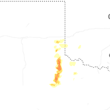
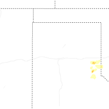
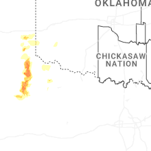
Texas
| Local Time | Report Details |
|---|---|
| 6:22 PM CDT | Quarter sized hail reported near Childress, TX, 5.6 miles N of Childress, TX, a few quarter sized stones observed... but mostly penny size or less. |
| 6:46 PM CDT | Golf Ball sized hail reported near Childress, TX, 4.4 miles SW of Childress, TX |
| 7:35 PM CDT | Ping Pong Ball sized hail reported near Paducah, TX, 25.6 miles S of Childress, TX |
| 8:10 PM CDT | Additional severe gusts of 59 to 62 mph measured from 809 pm to 812 p in cottle county TX, 36.8 miles S of Childress, TX |
| 8:55 PM CDT | Golf Ball sized hail reported near Guthrie, TX, 45.4 miles S of Childress, TX, hailstones ranging from quarter to golf ball size. |
| 9:24 PM CDT | Storm damage reported in king county TX, 55 miles S of Childress, TX |
| 10:34 PM CDT | Storm damage reported in king county TX, 60.6 miles S of Childress, TX |
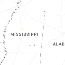
Mississippi
| Local Time | Report Details |
|---|---|
| 6:53 PM CDT | Reported large tree on home in the water valley area. exact time and location estimated on rada in yalobusha county MS, 64.9 miles NW of Starkville, MS |
Massachusetts
| Local Time | Report Details |
|---|---|
| 8:25 PM EDT | Report of a tree down in richmond. time estimated from rada in berkshire county MA, 42.2 miles SE of Schenectady, NY |
| 8:50 PM EDT | Tree down blocking route 2 around mile marker 26 near charlemont. relayed by amateur radi in franklin county MA, 58.1 miles ESE of Schenectady, NY |
| 9:00 PM EDT | Corrects previous tstm wnd dmg report from 2 sse buckland for time. tree downed on east buckland rd in buckland. relayed by amateur radi in franklin county MA, 61.2 miles ESE of Schenectady, NY |
| 9:10 PM EDT | Tree downed on east buckland rd in buckland. relayed by amateur radi in franklin county MA, 61.2 miles ESE of Schenectady, NY |
| 9:52 PM EDT | Report of a tree down in lenox. time estimated from rada in berkshire county MA, 45.6 miles SE of Schenectady, NY |
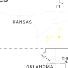
Kansas
| Local Time | Report Details |
|---|---|
| 9:55 PM CDT | Half Dollar sized hail reported near Fredonia, KS, 19.1 miles WSW of Chanute, KS |
| 10:34 PM CDT | Quarter sized hail reported near Le Roy, KS, 33.7 miles NNW of Chanute, KS, public reported hail with pictures sent to em. |
| 10:45 PM CDT | Storm damage reported in neosho county KS, 1 miles SSW of Chanute, KS |
| 11:16 PM CDT | Quarter sized hail reported near Erie, KS, 14 miles ESE of Chanute, KS |
Connect with Interactive Hail Maps