

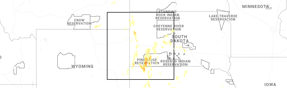
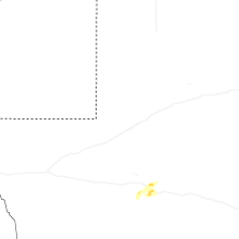
Hail Map for Saturday, May 30, 2026
Number of Impacted Households on 5/30/2026
0
Impacted by 1" or Larger Hail
0
Impacted by 1.75" or Larger Hail
0
Impacted by 2.5" or Larger Hail
Square Miles of Populated Area Impacted on 5/30/2026
0
Impacted by 1" or Larger Hail
0
Impacted by 1.75" or Larger Hail
0
Impacted by 2.5" or Larger Hail
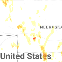
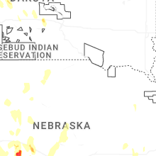
Cities Most Affected by Hail Storms of 5/30/2026
| Hail Size | Demographics of Zip Codes Affected | ||||||
|---|---|---|---|---|---|---|---|
| City | Count | Average | Largest | Pop Density | House Value | Income | Age |
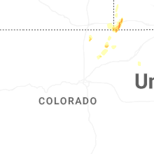
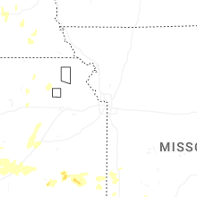
| Wellfleet, NE | 5 | 2.65 | 3.50 | 1 | $85k | $37.1k | 45.3 |
| Bushnell, NE | 4 | 2.44 | 2.75 | 0 | $20k | $28.1k | 53.3 |
| Wallace, NE | 2 | 2.38 | 2.75 | 1 | $55k | $36.5k | 42.3 |
| Elsie, NE | 1 | 1.75 | 1.75 | 1 | $36k | $40.4k | 46.2 |
| Holyoke, CO | 1 | 1.56 | 1.56 | 6 | $81k | $32.1k | 41.5 |
Hail and Wind Damage Spotted on 5/30/2026
Filter by Report Type:Hail ReportsWind Reports
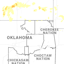
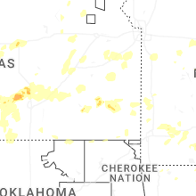
Arkansas
| Local Time | Report Details |
|---|---|
| 2:52 PM CDT | Multiple trees uproote in van buren county AR, 58.2 miles N of Little Rock, AR |
| 3:14 PM CDT | Large hardwood tree was blown dow in van buren county AR, 44.5 miles N of Little Rock, AR |
| 3:16 PM CDT | Large hardwood tree was blown down onto a house. the house sustained major structural damag in van buren county AR, 44.3 miles N of Little Rock, AR |
| 3:20 PM CDT | Co-op observer estimated winds at 60 mp in faulkner county AR, 42.8 miles N of Little Rock, AR |
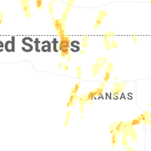
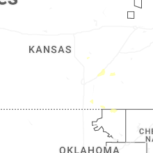
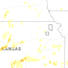
Kansas
| Local Time | Report Details |
|---|---|
| 3:05 PM CDT | Quarter sized hail reported near Fall River, KS, 32.1 miles W of Chanute, KS |
| 3:10 PM CDT | Half Dollar sized hail reported near Fall River, KS, 32.1 miles W of Chanute, KS |
| 3:15 PM CDT | Occasional gusts to 70 mph and pea-sized hai in wilson county KS, 12 miles W of Chanute, KS |
| 3:15 PM CDT | Half Dollar sized hail reported near Dodge City, KS, 55.3 miles ESE of Garden City, KS, public reported on social media dime to half dollar size hail. pictures were included in the post. |
| 3:20 PM CDT | Multiple 4+ in limbs down... gusts estimated 70+ mp in wilson county KS, 12 miles W of Chanute, KS |
| 3:48 PM CDT | Quarter sized hail reported near Chanute, KS, 0.5 miles WSW of Chanute, KS, report from mping: quarter (1.00 in.). |
| 4:08 PM CDT | Quarter sized hail reported near Sharon, KS, 63.9 miles WSW of Wichita, KS, report from mping: quarter (1.00 in.). |
| 4:20 PM CDT | Half Dollar sized hail reported near Bazine, KS, 34.9 miles SSW of Hays, KS, ham radio spotter reported quarter to half dollar size hail. |
| 4:23 PM CDT | Reports of limbs down... estimated 60-70+ mph gust in neosho county KS, 13.1 miles ESE of Chanute, KS |
| 4:33 PM CDT | Quarter sized hail reported near Zenda, KS, 54.1 miles WSW of Wichita, KS |
| 4:44 PM CDT | Ping Pong Ball sized hail reported near Kingman, KS, 38.2 miles W of Wichita, KS, time estimated from radar. |
| 4:53 PM CDT | Storm chaser reports minor damage to gas station canop in rush county KS, 22.9 miles S of Hays, KS |
| 5:01 PM CDT | Personal ambient weather networ in rush county KS, 25 miles S of Hays, KS |
| 5:45 PM CDT | Two to three inch diameter branches snapped. received via faceboo in reno county KS, 28.4 miles WNW of Wichita, KS |
| 5:45 PM CDT | Personal wx statio in sedgwick county KS, 19.1 miles WNW of Wichita, KS |
| 5:49 PM CDT | Trained spotter estimates 60 mph wind gust in norton county KS, 60 miles ENE of Colby, KS |
| 5:49 PM CDT | Half Dollar sized hail reported near Lenora, KS, 60 miles ENE of Colby, KS, trained spotter reports half dollar sized hail. |
| 5:56 PM CDT | Renner shop; davis statio in norton county KS, 62.1 miles ENE of Colby, KS |
| 5:57 PM CDT | Hutchinson regional airport (khut) aso in reno county KS, 38.5 miles NW of Wichita, KS |
| 6:05 PM CDT | Storm damage reported in reno county KS, 39.1 miles NW of Wichita, KS |
| 6:07 PM CDT | Quarter sized hail reported near Norton, KS, 67.7 miles ENE of Colby, KS, cocorahs report; picked up one stone that was 1 inch in diameter. most stones were 1/2 inch in diameter. not very many stones fell in total. |
| 6:17 PM CDT | Davis station; up nort in norton county KS, 62.8 miles NE of Colby, KS |
| 6:18 PM CDT | Knrn measured 53 knot gus in norton county KS, 69.1 miles ENE of Colby, KS |
| 6:30 PM CDT | Report from social media (x/twitter) - large branch down as well as smaller ones. est. 60 to 70 mph gust in harvey county KS, 28.7 miles NNW of Wichita, KS |
| 6:35 PM CDT | Gusts 50 to 60 mph with pea hai in barton county KS, 39.2 miles ESE of Hays, KS |
| 6:37 PM CDT | Quarter sized hail reported near Hoisington, KS, 38.4 miles SE of Hays, KS |
| 6:55 PM CDT | Gusts near 60 mp in harvey county KS, 30.2 miles N of Wichita, KS |
| 6:55 PM CDT | 50 to 60 mph winds with intense t-stor in lincoln county KS, 50.9 miles E of Hays, KS |
| 7:15 PM CDT | Quarter sized hail reported near Pretty Prairie, KS, 27.9 miles W of Wichita, KS |
| 7:37 PM CDT | Quarter sized hail reported near Andale, KS, 17.6 miles WNW of Wichita, KS, report from mping: quarter (1.00 in.). |
| 7:38 PM CDT | Quarter sized hail reported near Mount Hope, KS, 23.3 miles WNW of Wichita, KS |
| 7:38 PM CDT | Half Dollar sized hail reported near Andale, KS, 17.6 miles WNW of Wichita, KS, report from mping: half dollar (1.25 in.). |
| 7:40 PM CDT | Ping Pong Ball sized hail reported near Mount Hope, KS, 21.8 miles NW of Wichita, KS, 55 to 65 mph winds along with the hail. |
| 7:40 PM CDT | Half Dollar sized hail reported near Andale, KS, 17.6 miles WNW of Wichita, KS |
| 7:40 PM CDT | 55 to 65 mph winds with 1.5 in hai in sedgwick county KS, 21.8 miles NW of Wichita, KS |
| 7:41 PM CDT | Occurred with half-dollar size hail. delayed repor in sedgwick county KS, 17.6 miles WNW of Wichita, KS |
| 7:41 PM CDT | Ping Pong Ball sized hail reported near Andale, KS, 17.6 miles WNW of Wichita, KS, report from mping: ping pong ball (1.50 in.). |
| 8:05 PM CDT | Half Dollar sized hail reported near Sedgwick, KS, 16.7 miles NNW of Wichita, KS |
| 8:25 PM CDT | Quarter sized hail reported near Newton, KS, 19.6 miles N of Wichita, KS |
| 8:35 PM CDT | Quarter sized hail reported near Mount Hope, KS, 21.8 miles NW of Wichita, KS |
| 10:08 PM CDT | Half Dollar sized hail reported near Emporia, KS, 60.7 miles SSE of Manhattan, KS, mping report. |
| 10:27 PM CDT | Quarter sized hail reported near Ellsworth, KS, 60.7 miles E of Hays, KS |
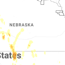
Nebraska
| Local Time | Report Details |
|---|---|
| 2:37 PM MDT | Quarter sized hail reported near Chadron, NE, 67.2 miles NNE of Scottsbluff, NE, media received report of quarter-sized hail at chadron state park. |
| 4:00 PM MDT | Golf Ball sized hail reported near Bushnell, NE, 51.9 miles SSW of Scottsbluff, NE, kimball county em reported golf ball sized hail within accumulating hail... leading to localized flash flooding in rural areas of kimball county. |
| 4:33 PM MDT | Baseball sized hail reported near Bushnell, NE, 48.3 miles S of Scottsbluff, NE, delayed report of baseball sized hail approximately 6.3 miles southeast of bushnell. time was estimated from radar reflectivity. multiple windows were destroyed. |
| 4:47 PM MDT | Quarter sized hail reported near Imperial, NE, 52.2 miles NE of Yuma, CO |
| 4:53 PM MDT | Baseball sized hail reported near Bushnell, NE, 48.3 miles S of Scottsbluff, NE, corrects previous hail report from 6.3 se bushnell. delayed report of baseball sized hail approximately 6.3 miles southeast of bushnell. time was estimated from radar r |
| 6:02 PM CDT | Quarter sized hail reported near Bartley, NE, 65.6 miles SSE of North Platte, NE, picture of quarter-sized hail in barley... ne. time estimated from radar. |
| 6:04 PM CDT | Quarter sized hail reported near Hayes Center, NE, 42.2 miles SSW of North Platte, NE |
| 5:15 PM MDT | Storm damage reported in keith county NE, 52.6 miles W of North Platte, NE |
| 6:21 PM CDT | Hen Egg sized hail reported near Wallace, NE, 36 miles SSW of North Platte, NE |
| 6:22 PM CDT | Baseball sized hail reported near Wallace, NE, 35.7 miles SSW of North Platte, NE |
| 5:27 PM MDT | Storm damage reported in keith county NE, 47.1 miles W of North Platte, NE |
| 5:30 PM MDT | Mesonet station up26 in kimball county NE, 44.7 miles SSE of Scottsbluff, NE |
| 6:39 PM CDT | Unofficial personal weather statio in furnas county NE, 69 miles SSE of North Platte, NE |
| 6:39 PM CDT | Unofficial weather statio in furnas county NE, 68.6 miles SSE of North Platte, NE |
| 5:42 PM MDT | Golf Ball sized hail reported near Elsie, NE, 39.2 miles WSW of North Platte, NE |
| 6:45 PM CDT | Half Dollar sized hail reported near Cambridge, NE, 67 miles SSE of North Platte, NE |
| 6:45 PM CDT | Unofficial personal weather statio in furnas county NE, 75.5 miles SSE of North Platte, NE |
| 6:45 PM CDT | Quarter sized hail reported near Cambridge, NE, 67.5 miles SSE of North Platte, NE, hail up to quarter size. |
| 6:47 PM CDT | Half Dollar sized hail reported near Wallace, NE, 31 miles SW of North Platte, NE |
| 6:51 PM CDT | Half Dollar sized hail reported near Cambridge, NE, 64.1 miles SSE of North Platte, NE |
| 6:52 PM CDT | 12 inch tree limb down...time estimated from rada in furnas county NE, 72.5 miles SE of North Platte, NE |
| 6:53 PM CDT | Awn; klink_weathe in red willow county NE, 63.1 miles SSE of North Platte, NE |
| 6:54 PM CDT | Quarter sized hail reported near Dickens, NE, 25.3 miles SSW of North Platte, NE |
| 7:08 PM CDT | Storm damage reported in frontier county NE, 49.8 miles SSE of North Platte, NE |
| 6:09 PM MDT | Golf aso in cheyenne county NE, 53 miles SSE of Scottsbluff, NE |
| 6:11 PM MDT | Storm damage reported in cheyenne county NE, 63.1 miles SSE of Scottsbluff, NE |
| 7:13 PM CDT | Storm damage reported in franklin county NE, 66.4 miles SSW of Grand Island, NE |
| 6:17 PM MDT | Mesonet station up252 8.1 w lodgepole (upr in cheyenne county NE, 66.3 miles SE of Scottsbluff, NE |
| 6:18 PM MDT | Awos station k1iw 7 se sidne in cheyenne county NE, 64.7 miles N of Yuma, CO |
| 6:18 PM MDT | Awos station k1iw 7 se sidne in cheyenne county NE, 64.7 miles N of Yuma, CO |
| 7:26 PM CDT | Quarter sized hail reported near Wellfleet, NE, 21.1 miles S of North Platte, NE |
| 7:29 PM CDT | Unofficial personal weather statio in gosper county NE, 59.2 miles SE of North Platte, NE |
| 7:32 PM CDT | Unofficial personal weather statio in dawson county NE, 56.1 miles ESE of North Platte, NE |
| 7:33 PM CDT | Quarter sized hail reported near Wellfleet, NE, 21.2 miles S of North Platte, NE |
| 7:34 PM CDT | Half Dollar sized hail reported near Wellfleet, NE, 21.3 miles S of North Platte, NE |
| 7:35 PM CDT | Hen Egg sized hail reported near Wellfleet, NE, 21.8 miles S of North Platte, NE |
| 7:40 PM CDT | Golf Ball sized hail reported near Wellfleet, NE, 21.2 miles S of North Platte, NE |
| 7:41 PM CDT | Unofficial personal weather statio in dawson county NE, 56 miles ESE of North Platte, NE |
| 7:46 PM CDT | Storm damage reported in dawson county NE, 57.2 miles ESE of North Platte, NE |
| 7:48 PM CDT | Tea Cup sized hail reported near Wellfleet, NE, 22.5 miles S of North Platte, NE |
| 7:50 PM CDT | Local media photos depict quite a bit of tree damage and a leaning power pole in lexington with power outages reported in the are in dawson county NE, 58.9 miles ESE of North Platte, NE |
| 7:51 PM CDT | Storm damage reported in dawson county NE, 56.2 miles ESE of North Platte, NE |
| 7:52 PM CDT | Unofficial personal weather statio in dawson county NE, 61.3 miles ESE of North Platte, NE |
| 7:53 PM CDT | Baseball sized hail reported near Wellfleet, NE, 21.8 miles S of North Platte, NE |
| 7:55 PM CDT | Quarter sized hail reported near Maxwell, NE, 12.8 miles ESE of North Platte, NE |
| 7:56 PM CDT | Tea Cup sized hail reported near Wellfleet, NE, 22.6 miles S of North Platte, NE |
| 6:56 PM MDT | Storm damage reported in grant county NE, 72.3 miles NW of North Platte, NE |
| 7:58 PM CDT | Ping Pong Ball sized hail reported near Brady, NE, 22 miles ESE of North Platte, NE |
| 8:00 PM CDT | Storm damage reported in dawson county NE, 58 miles ESE of North Platte, NE |
| 8:06 PM CDT | Storm damage reported in dawson county NE, 63.9 miles W of Grand Island, NE |
| 7:07 PM MDT | Storm damage reported in keith county NE, 66.1 miles W of North Platte, NE |
| 8:07 PM CDT | Unofficial personal weather statio in franklin county NE, 48.8 miles SSW of Grand Island, NE |
| 8:08 PM CDT | Corrects previous tstm wnd gst report from 4 se eddyvill in dawson county NE, 62.9 miles E of North Platte, NE |
| 8:09 PM CDT | Storm damage reported in dawson county NE, 62.9 miles E of North Platte, NE |
| 8:15 PM CDT | Storm damage reported in dawson county NE, 62.5 miles W of Grand Island, NE |
| 7:15 PM MDT | Storm damage reported in garden county NE, 69.3 miles WNW of North Platte, NE |
| 8:15 PM CDT | Storm damage reported in dawson county NE, 62.9 miles E of North Platte, NE |
| 8:17 PM CDT | Storm damage reported in dawson county NE, 62.5 miles W of Grand Island, NE |
| 8:17 PM CDT | Storm damage reported in nuckolls county NE, 57.3 miles S of Grand Island, NE |
| 8:26 PM CDT | Power lines snapped north of town. power lost in holstein. the fire department reported at tree was on fire as wel in adams county NE, 34.7 miles SSW of Grand Island, NE |
| 8:26 PM CDT | Storm damage reported in adams county NE, 36.8 miles SSW of Grand Island, NE |
| 8:29 PM CDT | Storm damage reported in adams county NE, 33.8 miles SSW of Grand Island, NE |
| 8:29 PM CDT | Storm damage reported in custer county NE, 60.2 miles WNW of Grand Island, NE |
| 8:30 PM CDT | Power pole down along highway 74 about 5 miles east of minde in kearney county NE, 40.1 miles SW of Grand Island, NE |
| 8:34 PM CDT | Storm damage reported in adams county NE, 34.9 miles SW of Grand Island, NE |
| 8:56 PM CDT | Storm damage reported in thayer county NE, 72.7 miles SSE of Grand Island, NE |
| 8:45 PM MDT | Tennis Ball sized hail reported near Bushnell, NE, 48.3 miles S of Scottsbluff, NE, delayed report of around 2.5 inches of precipitation throughout the duration of the storm event near bushnell. |
| 10:16 PM CDT | Quarter sized hail reported near Seward, NE, 61.3 miles E of Grand Island, NE, trained spotter report of hail up to 1 inch in diameter and wind gusts estimated at 55 mph. |
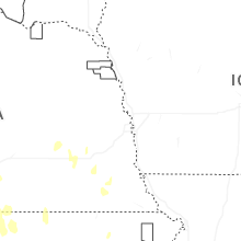
Missouri
| Local Time | Report Details |
|---|---|
| 4:10 PM CDT | Report of extensive damage to kennel... well... and barn at county road 120 and sumac ln southeast of jaspe in jasper county MO, 54.5 miles W of Springfield, MO |
| 5:30 PM CDT | Quarter sized hail reported near Aurora, MO, 28.8 miles SW of Springfield, MO, photo of quarter sized hail on prospect and wolfe rd in aurora. time estimated from radar. |
| 5:35 PM CDT | Multiple trees uprooted along farm road 23 and in greene county MO, 22 miles NW of Springfield, MO |
| 5:41 PM CDT | Tree down at intersection of county rd 2100 and highway n. time estimated from rada in lawrence county MO, 23.7 miles WSW of Springfield, MO |
| 5:54 PM CDT | Quarter sized hail reported near Republic, MO, 11.7 miles WSW of Springfield, MO, quarter sized hail in republic. |
| 6:00 PM CDT | 3 to 4 inch limbs down 3.2 miles north of mile marker 61 of interstate 44 in bois dar in greene county MO, 15.4 miles W of Springfield, MO |
| 7:00 PM CDT | Trees down in and around this area. two mile wide band of tree damage from lawrence and barry county line in barry county MO, 31.4 miles SW of Springfield, MO |
| 7:03 PM CDT | Trees down. widespread two mile wide band of tree damage from the lawrence and barry county line in lawrence county MO, 24.9 miles SW of Springfield, MO |
| 7:56 PM CDT | Quarter sized hail reported near Chestnutridge, MO, 26.9 miles S of Springfield, MO, public sent in a photo of a person holding a hail stone around the size of a quarter. |
| 8:00 PM CDT | Several trees dow in taney county MO, 35.2 miles S of Springfield, MO |
| 8:35 PM CDT | Liberty utilities employee reported 225 customers without power in the branson and reeds spring area due to downed trees and thunderstorm win in taney county MO, 38.8 miles S of Springfield, MO |
Texas
| Local Time | Report Details |
|---|---|
| 5:00 PM CDT | Quarter sized hail reported near Childress, TX, 24.2 miles WSW of Childress, TX |
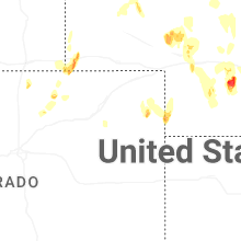
Colorado
| Local Time | Report Details |
|---|---|
| 4:15 PM MDT | Ping Pong Ball sized hail reported near Akron, CO, 26 miles W of Yuma, CO |
| 5:00 PM MDT | Ping Pong Ball sized hail reported near Holyoke, CO, 30.6 miles NE of Yuma, CO, storm chaser measure 1.56 inch hail. |
| 5:40 PM MDT | Quarter sized hail reported near Akron, CO, 28.6 miles W of Yuma, CO |
| 5:59 PM MDT | Private weather statio in logan county CO, 61.6 miles NNW of Yuma, CO |
| 6:39 PM MDT | Mesonet station up46 in sedgwick county CO, 63.1 miles NNE of Yuma, CO |
| 6:46 PM MDT | Quarter sized hail reported near Holyoke, CO, 33.9 miles NE of Yuma, CO |
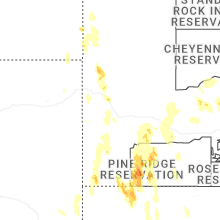
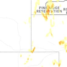
South Dakota
| Local Time | Report Details |
|---|---|
| 5:00 PM MDT | Ping Pong Ball sized hail reported near Oglala, SD, 67 miles SSE of Rapid City, SD, tweet sent by local broadcast media and tagged nws. |
| 5:00 PM MDT | Ping Pong Ball sized hail reported near Oglala, SD, 61 miles SSE of Rapid City, SD, tweet sent by local broadcast media and tagged nws. |
Georgia
| Local Time | Report Details |
|---|---|
| 7:32 PM EDT | One tree down near the intersection of east park ave and drayton street. time estimated based on rada in chatham county GA, 1.5 miles SSW of Savannah, GA |
| 7:47 PM EDT | Trees down on 1500 block on rosewood drive. damage likely caused by outflow winds. time estimated based on rada in chatham county GA, 6.3 miles S of Savannah, GA |
Connect with Interactive Hail Maps