

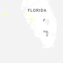
Hail Map for Saturday, May 2, 2026

Number of Impacted Households on 5/2/2026
0
Impacted by 1" or Larger Hail
0
Impacted by 1.75" or Larger Hail
0
Impacted by 2.5" or Larger Hail
Square Miles of Populated Area Impacted on 5/2/2026
0
Impacted by 1" or Larger Hail
0
Impacted by 1.75" or Larger Hail
0
Impacted by 2.5" or Larger Hail
Cities Most Affected by Hail Storms of 5/2/2026
| Hail Size | Demographics of Zip Codes Affected | ||||||
|---|---|---|---|---|---|---|---|
| City | Count | Average | Largest | Pop Density | House Value | Income | Age |
Hail and Wind Damage Spotted on 5/2/2026
Filter by Report Type:Hail ReportsWind Reports
States Impacted
FloridaFlorida
| Local Time | Report Details |
|---|---|
| 1:25 PM EDT | Downed tree damaged a car in southeast ocala. time estimated via rada in marion county FL, 58.5 miles NW of Orlando, FL |
| 1:25 PM EDT | Damage to a roof and gutters in the marion oaks area. time estimated via rada in marion county FL, 58.5 miles NW of Orlando, FL |
| 2:45 PM EDT | Ussf wind sensor on tower 1 measured a peak wind gust of 59mph/51kt from the northwest at 2:45 pm. earlier... a gust to 48mph/42kt occurred at 2:40 pm. sensor elevation in brevard county FL, 43.4 miles ENE of Orlando, FL |
| 2:47 PM EDT | Cocoa beach... cape canaveral air force station skid strip measured a peak wind gust of 59mph/51kt from the west at 2:47 p in brevard county FL, 49.3 miles E of Orlando, FL |
| 3:55 PM EDT | Dead trees on the side of i-75 blown over with small tree limbs debris in roadwa in hillsborough county FL, 14.1 miles NE of Bradenton, FL |
Connect with Interactive Hail Maps