

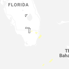
Hail Map for Tuesday, April 7, 2026

Number of Impacted Households on 4/7/2026
0
Impacted by 1" or Larger Hail
0
Impacted by 1.75" or Larger Hail
0
Impacted by 2.5" or Larger Hail
Square Miles of Populated Area Impacted on 4/7/2026
0
Impacted by 1" or Larger Hail
0
Impacted by 1.75" or Larger Hail
0
Impacted by 2.5" or Larger Hail
Cities Most Affected by Hail Storms of 4/7/2026
| Hail Size | Demographics of Zip Codes Affected | ||||||
|---|---|---|---|---|---|---|---|
| City | Count | Average | Largest | Pop Density | House Value | Income | Age |
Hail and Wind Damage Spotted on 4/7/2026
Filter by Report Type:Hail ReportsWind Reports
Florida
| Local Time | Report Details |
|---|---|
| 3:17 PM EDT | Mesonet station xgvt government cut measured a 73 mph gust under the core of a downburs in amz651 county FL, 8.7 miles E of Miami, FL |
| 4:57 PM EDT | Miami-dade county reported straight line wind damage in hialeah as a severe thunderstorm moved through the area... two homes were damage in miami-dade county FL, 15.6 miles NNW of Miami, FL |
Wyoming
| Local Time | Report Details |
|---|---|
| 9:41 PM MDT | Storm damage reported in crook county WY, 50.8 miles NNE of Gillette, WY |
Connect with Interactive Hail Maps