

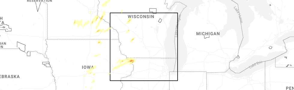
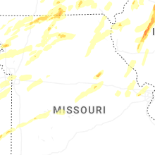
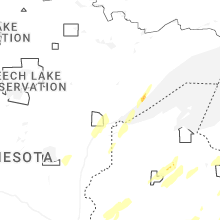
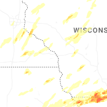
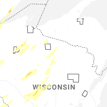
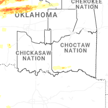
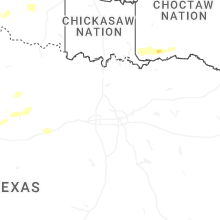
Hail Map for Friday, April 17, 2026
Number of Impacted Households on 4/17/2026
0
Impacted by 1" or Larger Hail
0
Impacted by 1.75" or Larger Hail
0
Impacted by 2.5" or Larger Hail
Square Miles of Populated Area Impacted on 4/17/2026
0
Impacted by 1" or Larger Hail
0
Impacted by 1.75" or Larger Hail
0
Impacted by 2.5" or Larger Hail


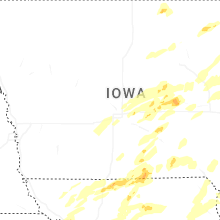
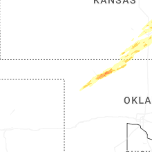
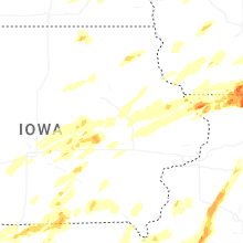

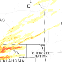
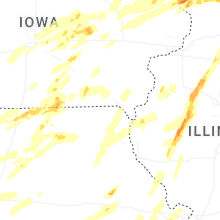
Cities Most Affected by Hail Storms of 4/17/2026
| Hail Size | Demographics of Zip Codes Affected | ||||||
|---|---|---|---|---|---|---|---|
| City | Count | Average | Largest | Pop Density | House Value | Income | Age |
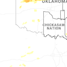
| Lamont, OK | 3 | 3.00 | 3.25 | 3 | $27k | $24.5k | 41.7 |
| Cherokee, OK | 4 | 2.25 | 2.75 | 8 | $33k | $30.3k | 45.3 |
| Jet, OK | 3 | 2.67 | 3.00 | 3 | $26k | $26.7k | 53.4 |
| Pond Creek, OK | 4 | 1.81 | 2.00 | 4 | $40k | $31.5k | 41.5 |
| Toledo, IA | 3 | 2.08 | 2.50 | 36 | $64k | $34.5k | 41.5 |
| Durand, IL | 3 | 1.92 | 2.25 | 36 | $100k | $50.9k | 42.8 |
| Galena, IL | 3 | 1.75 | 1.75 | 72 | $117k | $42.4k | 50.8 |
| Freeport, IL | 2 | 2.38 | 3.00 | 209 | $77k | $38.1k | 42.9 |
| Dakota, IL | 2 | 2.25 | 2.75 | 25 | $78k | $41.7k | 40.1 |
| Tama, IA | 2 | 2.13 | 2.50 | 44 | $61k | $34.8k | 35.7 |
| Davis, IL | 2 | 2.13 | 2.25 | 97 | $118k | $56.2k | 49.1 |
| Ponca City, OK | 2 | 1.88 | 2.00 | 123 | $45k | $26.2k | 34.5 |
| Toulon, IL | 2 | 1.88 | 2.00 | 13 | $62k | $36.2k | 46.4 |
| Beloit, WI | 2 | 1.88 | 2.00 | 442 | $76k | $39.5k | 36.3 |
| Saint Joseph, MO | 2 | 1.75 | 1.75 | 302 | $71k | $37.7k | 38.3 |
| Okeene, OK | 2 | 1.75 | 1.75 | 5 | $40k | $31.3k | 43.2 |
| Hanover, IL | 2 | 1.75 | 1.75 | 12 | $60k | $32.3k | 47.4 |
| Monroe, WI | 1 | 2.75 | 2.75 | 100 | $95k | $39.6k | 42.3 |
| Russell, IA | 1 | 2.50 | 2.50 | 9 | $42k | $33.9k | 44.1 |
| Enid, OK | 1 | 2.50 | 2.50 | 170 | $39k | $26.6k | 33.1 |
| Marshall, OK | 1 | 2.50 | 2.50 | 3 | $22k | $28.1k | 44.1 |
| Ipava, IL | 1 | 2.00 | 2.00 | 10 | $40k | $34.6k | 45.4 |
| Tonkawa, OK | 1 | 2.00 | 2.00 | 29 | $42k | $29.3k | 33.2 |
| Pecatonica, IL | 1 | 2.00 | 2.00 | 40 | $103k | $50.1k | 41.5 |
| Dacoma, OK | 1 | 2.00 | 2.00 | 3 | $20k | $16.9k | 49.5 |
| Kremlin, OK | 1 | 1.75 | 1.75 | 5 | $62k | $36.3k | 40.4 |
| Hayfield, MN | 1 | 1.75 | 1.75 | 22 | $87k | $45.3k | 38.5 |
| Rushville, IL | 1 | 1.75 | 1.75 | 30 | $58k | $35.3k | 43.1 |
| Rock City, IL | 1 | 1.75 | 1.75 | 27 | $87k | $41.1k | 42.1 |
| Chester, OK | 1 | 1.75 | 1.75 | 3 | $47k | $31.4k | 45.7 |
| Monroe, IA | 1 | 1.75 | 1.75 | 14 | $79k | $42.0k | 41.1 |
| Newton, IA | 1 | 1.75 | 1.75 | 119 | $82k | $40.9k | 41.7 |
| Melbourne, IA | 1 | 1.75 | 1.75 | 16 | $73k | $48.9k | 37.4 |
| Aline, OK | 1 | 1.75 | 1.75 | 3 | $24k | $31.7k | 48.7 |
| Kansas City, MO | 1 | 1.75 | 1.75 | 4775 | $35k | $18.8k | 28.6 |
| Derby, KS | 1 | 1.75 | 1.75 | 492 | $108k | $60.1k | 36.2 |
| Nash, OK | 1 | 1.75 | 1.75 | 2 | $47k | $28.5k | 49.2 |
| Rochester, MN | 1 | 1.75 | 1.75 | 1787 | $117k | $52.6k | 33.4 |
| Elizabeth, IL | 1 | 1.75 | 1.75 | 16 | $77k | $36.3k | 47.3 |
| Milton, WI | 1 | 1.75 | 1.75 | 179 | $126k | $52.3k | 39.4 |
Hail and Wind Damage Spotted on 4/17/2026
Filter by Report Type:Hail ReportsWind Reports
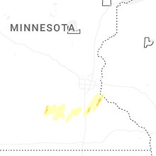
Minnesota
| Local Time | Report Details |
|---|---|
| 7:12 AM CDT | Quarter sized hail reported near New Ulm, MN, 74.9 miles SW of Minneapolis, MN, photo measurement provided via nwschat. time estimated via radar. |
| 8:00 AM CDT | Quarter sized hail reported near Kasota, MN, 58.9 miles SW of Minneapolis, MN, report received via nwschat. time estimated via radar. |
| 9:30 AM CDT | Quarter sized hail reported near Faribault, MN, 44.9 miles S of Minneapolis, MN |
| 10:08 AM CDT | Quarter sized hail reported near Cannon Falls, MN, 38 miles SSE of Minneapolis, MN |
| 10:12 AM CDT | Quarter sized hail reported near Cannon Falls, MN, 38.4 miles SSE of Minneapolis, MN, hail measurement photo provided via nwschat. time estimated via radar. |
| 1:36 PM CDT | Golf Ball sized hail reported near Hayfield, MN, 53.9 miles NNE of Mason City, IA |
| 1:37 PM CDT | Quarter sized hail reported near Hayfield, MN, 54.3 miles NNE of Mason City, IA |
| 1:45 PM CDT | Quarter sized hail reported near Kasson, MN, 63.8 miles NNE of Mason City, IA |
| 2:05 PM CDT | Ping Pong Ball sized hail reported near Red Wing, MN, 46.7 miles SE of Minneapolis, MN, report from mping: ping pong ball (1.50 in.). |
| 2:08 PM CDT | Quarter sized hail reported near Red Wing, MN, 48.6 miles SE of Minneapolis, MN, report from mping: quarter (1.00 in.). |
| 2:08 PM CDT | Half Dollar sized hail reported near Red Wing, MN, 46.7 miles SE of Minneapolis, MN, report from mping: half dollar (1.25 in.). |
| 2:10 PM CDT | Quarter sized hail reported near Red Wing, MN, 46.7 miles SE of Minneapolis, MN, report from mping: quarter (1.00 in.). |
| 2:12 PM CDT | Ping Pong Ball sized hail reported near Red Wing, MN, 48.6 miles SE of Minneapolis, MN, report from mping: ping pong ball (1.50 in.). |
| 2:13 PM CDT | Golf Ball sized hail reported near Rochester, MN, 63.8 miles WNW of La Crosse, WI |
| 2:40 PM CDT | Quarter sized hail reported near Red Wing, MN, 48.6 miles SE of Minneapolis, MN, report from mping: quarter (1.00 in.). |
| 2:41 PM CDT | Quarter sized hail reported near Red Wing, MN, 47.6 miles SE of Minneapolis, MN, report from mping: quarter (1.00 in.). |
| 3:00 PM CDT | Picture via social media of three 5 inch diameter softwood trees broken a few feet up the trunks. time estimated from rada in st. louis county MN, 1.3 miles NW of Duluth, MN |
| 3:01 PM CDT | Quarter sized hail reported near Duluth, MN, 10.3 miles WNW of Duluth, MN |
| 3:05 PM CDT | Quarter sized hail reported near Altura, MN, 38.7 miles WNW of La Crosse, WI |
| 3:12 PM CDT | Quarter sized hail reported near Two Harbors, MN, 28.7 miles NE of Duluth, MN, report via social media. |
| 3:19 PM CDT | Quarter sized hail reported near Rollingstone, MN, 34.6 miles NW of La Crosse, WI, emergency manager reported quarter size hail in rollingstone. |
| 3:20 PM CDT | Ping Pong Ball sized hail reported near Two Harbors, MN, 32.2 miles NE of Duluth, MN, majority of hail was three quarters to one inch in size but some pieces as large as 1.5 inches. photo sent to nws duluth. time estimated from radar. |
| 3:51 PM CDT | Half Dollar sized hail reported near Duluth, MN, 10.7 miles WNW of Duluth, MN, mostly pea size but a few one inch to one and a quarter inch found about 45 minutes after the storm passed. |
Iowa
| Local Time | Report Details |
|---|---|
| 12:49 PM CDT | Quarter sized hail reported near Monticello, IA, 24.2 miles NE of Cedar Rapids, IA, report from mping: quarter (1.00 in.). |
| 1:25 PM CDT | Quarter sized hail reported near Cascade, IA, 40 miles ENE of Cedar Rapids, IA, report from mping: quarter (1.00 in.). |
| 1:58 PM CDT | Quarter sized hail reported near Ankeny, IA, 9.7 miles N of Des Moines, IA |
| 2:01 PM CDT | Half Dollar sized hail reported near Cumming, IA, 10.6 miles SW of Des Moines, IA, time estimated from radar. |
| 2:04 PM CDT | Quarter sized hail reported near Des Moines, IA, 4.2 miles N of Des Moines, IA, report from mping: quarter (1.00 in.). |
| 2:05 PM CDT | Half Dollar sized hail reported near Ankeny, IA, 6.7 miles NNE of Des Moines, IA, reported by trained spotter. |
| 2:11 PM CDT | Ping Pong Ball sized hail reported near Des Moines, IA, 0.7 miles SSW of Des Moines, IA, multiple reports across the metro of 1 to 1.5 inch hail. time/location estimated from radar. |
| 2:17 PM CDT | Powerline snapped and sheet metal roof ripped off. tornado possibl in jackson county IA, 47.9 miles ENE of Cedar Rapids, IA |
| 2:21 PM CDT | Quarter sized hail reported near Collins, IA, 26.6 miles NE of Des Moines, IA, report from mping: quarter (1.00 in.). |
| 2:25 PM CDT | Quarter sized hail reported near Knoxville, IA, 33.5 miles ESE of Des Moines, IA |
| 2:26 PM CDT | Quarter sized hail reported near Mitchellville, IA, 11.9 miles E of Des Moines, IA |
| 2:39 PM CDT | Golf Ball sized hail reported near Melbourne, IA, 36 miles NE of Des Moines, IA |
| 2:40 PM CDT | Ping Pong Ball sized hail reported near Colfax, IA, 21.1 miles ENE of Des Moines, IA, time estimated via radar. |
| 2:41 PM CDT | Half Dollar sized hail reported near Colfax, IA, 21 miles ENE of Des Moines, IA, report from mping: half dollar (1.25 in.). |
| 2:45 PM CDT | Ping Pong Ball sized hail reported near Colfax, IA, 20.4 miles ENE of Des Moines, IA, time estimated from radar. |
| 2:50 PM CDT | Golf Ball sized hail reported near Newton, IA, 29.8 miles ENE of Des Moines, IA |
| 2:51 PM CDT | Golf Ball sized hail reported near Monroe, IA, 26.8 miles E of Des Moines, IA, time estimated on radar. |
| 2:53 PM CDT | Quarter sized hail reported near Weldon, IA, 44.8 miles S of Des Moines, IA |
| 2:55 PM CDT | Tennis Ball sized hail reported near Russell, IA, 47.6 miles SSE of Des Moines, IA, time and location estimated from radar. |
| 3:04 PM CDT | Quarter sized hail reported near Tama, IA, 46.7 miles W of Cedar Rapids, IA |
| 3:05 PM CDT | Golf Ball sized hail reported near Tama, IA, 46.7 miles W of Cedar Rapids, IA, time estimated from radar. |
| 3:08 PM CDT | Ping Pong Ball sized hail reported near Tama, IA, 46.2 miles W of Cedar Rapids, IA |
| 3:10 PM CDT | Tennis Ball sized hail reported near Toledo, IA, 46.7 miles W of Cedar Rapids, IA, time estimated from radar. |
| 3:10 PM CDT | Golf Ball sized hail reported near Toledo, IA, 46.7 miles W of Cedar Rapids, IA |
| 3:14 PM CDT | Tennis Ball sized hail reported near Tama, IA, 46.2 miles W of Cedar Rapids, IA |
| 3:16 PM CDT | Hen Egg sized hail reported near Toledo, IA, 46.7 miles W of Cedar Rapids, IA |
| 3:18 PM CDT | Quarter sized hail reported near Melrose, IA, 51.4 miles SE of Des Moines, IA |
| 3:23 PM CDT | Quarter sized hail reported near Bussey, IA, 45.9 miles SE of Des Moines, IA |
| 3:25 PM CDT | Quarter sized hail reported near New Sharon, IA, 49.2 miles E of Des Moines, IA, report from mping: quarter (1.00 in.) time estimated from radar. |
| 3:28 PM CDT | Quarter sized hail reported near New Sharon, IA, 50.8 miles E of Des Moines, IA, report from mping: quarter (1.00 in.) time estimated from radar. |
| 3:36 PM CDT | Quarter sized hail reported near Cedar Rapids, IA, 5.2 miles NNE of Cedar Rapids, IA, report from mping: quarter (1.00 in.). |
| 3:48 PM CDT | Quarter sized hail reported near Plano, IA, 61.4 miles SSE of Des Moines, IA |
| 3:53 PM CDT | Quarter sized hail reported near Hiawatha, IA, 5.1 miles N of Cedar Rapids, IA, relayed by county em. |
| 3:53 PM CDT | Quarter sized hail reported near Robins, IA, 7.2 miles N of Cedar Rapids, IA, relayed via county em. |
| 3:53 PM CDT | Quarter sized hail reported near Toddville, IA, 8.9 miles NNW of Cedar Rapids, IA, delayed report. relayed via county em. |
| 4:02 PM CDT | Quarter sized hail reported near Central City, IA, 12.5 miles NNE of Cedar Rapids, IA |
| 4:03 PM CDT | Relayed via county em. also pea sized hai in linn county IA, 22.3 miles NNW of Cedar Rapids, IA |
| 4:18 PM CDT | Quarter sized hail reported near Postville, IA, 52.4 miles SSW of La Crosse, WI, quarter size hail in postville relayed from emergency manager. |
| 4:20 PM CDT | Report relayed by emergency manager. time estimated by rada in delaware county IA, 49.2 miles NNE of Cedar Rapids, IA |
| 4:20 PM CDT | Numerous trees down. time estimated by rada in davis county IA, 45.1 miles WNW of Kahoka, MO |
| 4:50 PM CDT | Half Dollar sized hail reported near Hopkinton, IA, 37.4 miles NE of Cedar Rapids, IA |
| 4:52 PM CDT | Tree limbs several inches in diameter dow in washington county IA, 53.9 miles SSW of Cedar Rapids, IA |
| 4:52 PM CDT | Report relayed by emergency manager. time estimated by rada in dubuque county IA, 38.6 miles NE of Cedar Rapids, IA |
| 5:00 PM CDT | Storm damage reported in dubuque county IA, 40.7 miles NE of Cedar Rapids, IA |
| 5:00 PM CDT | Storm damage reported in washington county IA, 46.7 miles S of Cedar Rapids, IA |
| 5:01 PM CDT | Storm damage reported in washington county IA, 49.4 miles S of Cedar Rapids, IA |
| 5:01 PM CDT | Semi truck blown over at the intersection of state hwy 1 and 92. tornado possible. time estimated by rada in washington county IA, 44 miles S of Cedar Rapids, IA |
| 5:03 PM CDT | Downed power poles and metal roof blown off of farm building. tornado possible. time estimated from rada in washington county IA, 39.8 miles S of Cedar Rapids, IA |
| 5:03 PM CDT | Large tree fallen down and multiple 6+ inch thick branches snapped. time estimated from rada in lee county IA, 27 miles NE of Kahoka, MO |
| 5:10 PM CDT | Building damage in washington county IA, 41.2 miles S of Cedar Rapids, IA |
| 5:10 PM CDT | Report of cattle barn damaged with debris scattered. roof blown off. possible tornado. time estimated by rada in washington county IA, 41.2 miles S of Cedar Rapids, IA |
| 5:12 PM CDT | Storm damage reported in washington county IA, 40.5 miles S of Cedar Rapids, IA |
| 5:12 PM CDT | Storm damage reported in jackson county IA, 47.2 miles ENE of Cedar Rapids, IA |
| 5:20 PM CDT | Rwi in jones county IA, 18.4 miles ENE of Cedar Rapids, IA |
| 5:29 PM CDT | Storm damage reported in henry county IA, 48 miles NNE of Kahoka, MO |
| 5:41 PM CDT | Large tree fallen down and multiple thick limbs snapped. time estimated from rada in lee county IA, 27 miles NE of Kahoka, MO |
| 5:47 PM CDT | Storm damage reported in louisa county IA, 59.2 miles SSE of Cedar Rapids, IA |
| 5:49 PM CDT | Storm damage reported in cedar county IA, 41.4 miles SE of Cedar Rapids, IA |
| 5:56 PM CDT | Measured using a car anemomete in cedar county IA, 45.7 miles ESE of Cedar Rapids, IA |
| 6:15 PM CDT | Storm damage reported in scott county IA, 53.5 miles ESE of Cedar Rapids, IA |
| 6:15 PM CDT | Storm damage reported in scott county IA, 55 miles ESE of Cedar Rapids, IA |
| 6:19 PM CDT | Aso in scott county IA, 61.4 miles ESE of Cedar Rapids, IA |
| 6:26 PM CDT | Quarter sized hail reported near Clive, IA, 12.3 miles W of Des Moines, IA, public report relayed via meteorologist. |
| 6:34 PM CDT | Awo in clinton county IA, 70 miles E of Cedar Rapids, IA |
| 6:35 PM CDT | Storm damage reported in clinton county IA, 69.3 miles E of Cedar Rapids, IA |
Missouri
| Local Time | Report Details |
|---|---|
| 1:23 PM CDT | Quarter sized hail reported near Maryville, MO, 85.3 miles SE of Omaha, NE, social media report. time estimated from radar. |
| 1:28 PM CDT | Half Dollar sized hail reported near Maryville, MO, 85.3 miles SE of Omaha, NE |
| 2:43 PM CDT | Ping Pong Ball sized hail reported near Darlington, MO, 76.3 miles N of Kansas City, MO |
| 2:51 PM CDT | Quarter sized hail reported near Saint Joseph, MO, 55.8 miles NNW of Kansas City, MO |
| 2:53 PM CDT | Golf Ball sized hail reported near Saint Joseph, MO, 51.7 miles NNW of Kansas City, MO |
| 2:54 PM CDT | Quarter sized hail reported near Union Star, MO, 61.2 miles N of Kansas City, MO |
| 2:56 PM CDT | Quarter sized hail reported near Saint Joseph, MO, 51.7 miles NNW of Kansas City, MO |
| 3:00 PM CDT | Quarter sized hail reported near Columbia, MO, 5.7 miles S of Columbia, MO |
| 3:00 PM CDT | Quarter sized hail reported near Cosby, MO, 53.7 miles N of Kansas City, MO |
| 3:03 PM CDT | Golf Ball sized hail reported near Saint Joseph, MO, 52.8 miles NNW of Kansas City, MO |
| 3:05 PM CDT | Social media report of a downed tree in moberly. time estimated from rada in randolph county MO, 32.6 miles N of Columbia, MO |
| 3:10 PM CDT | Power pole dow in st. charles county MO, 39.7 miles WNW of Saint Louis, MO |
| 3:12 PM CDT | Trees and transformer down on roa in st. charles county MO, 41.1 miles W of Saint Louis, MO |
| 3:13 PM CDT | Quarter sized hail reported near Helena, MO, 55.8 miles N of Kansas City, MO |
| 3:15 PM CDT | Tree down on powerlin in st. charles county MO, 39.7 miles WNW of Saint Louis, MO |
| 3:15 PM CDT | Powerlines on roa in st. charles county MO, 39.5 miles WNW of Saint Louis, MO |
| 3:15 PM CDT | Tree/branches... powerlines on roa in st. charles county MO, 39.8 miles WNW of Saint Louis, MO |
| 3:15 PM CDT | Quarter sized hail reported near Saint Charles, MO, 29.3 miles W of Saint Louis, MO, report from mping: quarter (1.00 in.). |
| 3:18 PM CDT | Quarter sized hail reported near Bethany, MO, 85.7 miles NNE of Kansas City, MO |
| 3:20 PM CDT | Power poles snapped with lots of wires down along hwy 6 in st. charles county MO, 41.4 miles WNW of Saint Louis, MO |
| 3:24 PM CDT | Report of a 6inch limb snappe in lincoln county MO, 46.5 miles WNW of Saint Louis, MO |
| 3:25 PM CDT | Corrects previous tstm wnd dmg report from 3 n flint hill. power pole snappe in lincoln county MO, 40.8 miles WNW of Saint Louis, MO |
| 3:25 PM CDT | Report of trees down and limbs snapped of in st. charles county MO, 41.4 miles WNW of Saint Louis, MO |
| 3:27 PM CDT | 6 inch diameter tree limb down out of healthy tre in lincoln county MO, 47.4 miles WNW of Saint Louis, MO |
| 3:28 PM CDT | Power poles snapped along martin roa in lincoln county MO, 40.3 miles WNW of Saint Louis, MO |
| 3:30 PM CDT | Power pole snappe in lincoln county MO, 40.8 miles WNW of Saint Louis, MO |
| 3:32 PM CDT | Quarter sized hail reported near Faucett, MO, 38.2 miles NNW of Kansas City, MO, social media report. time estimated from radar. |
| 3:35 PM CDT | Quarter sized hail reported near Chesterfield, MO, 22.9 miles W of Saint Louis, MO |
| 3:35 PM CDT | Tree with shallow root system came down as well as 4-6 inch and 12 inch limbs dow in lincoln county MO, 41.4 miles NW of Saint Louis, MO |
| 3:37 PM CDT | Report of a 5 inch diameter tree limb snappe in lincoln county MO, 38.4 miles NW of Saint Louis, MO |
| 3:39 PM CDT | Downed wires near route 6. time estimated from rada in buchanan county MO, 47.5 miles N of Kansas City, MO |
| 3:39 PM CDT | Quarter sized hail reported near Saint Charles, MO, 24 miles WNW of Saint Louis, MO, report from mping: quarter (1.00 in.). |
| 3:40 PM CDT | Quarter sized hail reported near Saint Charles, MO, 23.6 miles WNW of Saint Louis, MO |
| 3:40 PM CDT | Tree on powerlin in st. charles county MO, 23.5 miles WNW of Saint Louis, MO |
| 3:42 PM CDT | Quarter sized hail reported near Saint Charles, MO, 22.3 miles WNW of Saint Louis, MO |
| 3:44 PM CDT | Quarter sized hail reported near Trenton, MO, 84.8 miles NE of Kansas City, MO |
| 3:45 PM CDT | Quarter sized hail reported near Saint Charles, MO, 22 miles WNW of Saint Louis, MO, report from mping: quarter (1.00 in.). |
| 3:45 PM CDT | Quarter sized hail reported near Saint Charles, MO, 20.2 miles WNW of Saint Louis, MO, report from social media... largest hail stone around 1 inch. |
| 3:46 PM CDT | Quarter sized hail reported near Saint Charles, MO, 21 miles WNW of Saint Louis, MO, report from mping: quarter (1.00 in.). |
| 3:47 PM CDT | Quarter sized hail reported near Chillicothe, MO, 73.7 miles NE of Kansas City, MO, social media report. time estimated from radar. |
| 3:48 PM CDT | Quarter sized hail reported near Saint Peters, MO, 26 miles WNW of Saint Louis, MO |
| 3:49 PM CDT | Quarter sized hail reported near Saint Peters, MO, 22 miles WNW of Saint Louis, MO, report from mping: quarter (1.00 in.). |
| 3:51 PM CDT | Downed tree limbs in wheeling. time estimated from rada in livingston county MO, 79.5 miles NE of Kansas City, MO |
| 3:51 PM CDT | Quarter sized hail reported near Chillicothe, MO, 73.1 miles NE of Kansas City, MO, social media report. time estimated from radar. |
| 4:00 PM CDT | Quarter sized hail reported near Mexico, MO, 28.7 miles ENE of Columbia, MO |
| 4:00 PM CDT | Quarter sized hail reported near Mexico, MO, 29 miles ENE of Columbia, MO |
| 4:00 PM CDT | Quarter sized hail reported near Agency, MO, 37.6 miles N of Kansas City, MO, social media report. time estimated from radar. |
| 4:03 PM CDT | Quarter sized hail reported near Mexico, MO, 28.2 miles ENE of Columbia, MO, report from mping: quarter (1.00 in.). |
| 4:05 PM CDT | Quarter sized hail reported near Saint Charles, MO, 20.4 miles WNW of Saint Louis, MO, report from mping: quarter (1.00 in.). |
| 4:08 PM CDT | Quarter sized hail reported near Saint Charles, MO, 21 miles NW of Saint Louis, MO |
| 4:15 PM CDT | Quarter sized hail reported near Saint Charles, MO, 20.1 miles NW of Saint Louis, MO, report from mping: quarter (1.00 in.). |
| 4:15 PM CDT | Quarter sized hail reported near Gower, MO, 35 miles N of Kansas City, MO, social media report. time estimated from radar. |
| 4:19 PM CDT | Quarter sized hail reported near Laredo, MO, 88 miles NE of Kansas City, MO |
| 4:40 PM CDT | Multiple reports of trees and wires down in cameron. time estimated from rada in clinton county MO, 47.6 miles NNE of Kansas City, MO |
| 4:45 PM CDT | Private weather senso in daviess county MO, 51.6 miles NNE of Kansas City, MO |
| 4:47 PM CDT | Golf Ball sized hail reported near Kansas City, MO, 0.5 miles NNE of Kansas City, MO, report from mping: golf ball (1.75 in.). |
| 4:48 PM CDT | Several reports of power lines down and power outages in southern daviess county. time estimated from rada in daviess county MO, 55.6 miles NNE of Kansas City, MO |
| 4:49 PM CDT | Mkc asos measured a 63 mph wind gus in clay county MO, 1.5 miles NW of Kansas City, MO |
| 4:50 PM CDT | Power lines down and one tree in a hous in caldwell county MO, 49.1 miles NNE of Kansas City, MO |
| 4:56 PM CDT | Quarter sized hail reported near Independence, MO, 11.5 miles E of Kansas City, MO, report from mping: quarter (1.00 in.). |
| 4:58 PM CDT | Multiple reports of power lines and trees down in northwest and north-central caldwell county from strong winds. time estimated from rada in caldwell county MO, 56.2 miles NNE of Kansas City, MO |
| 5:08 PM CDT | Downed tee limb and wires near glen arbor terrace. time confirmed from rada in jackson county MO, 12.7 miles S of Kansas City, MO |
| 5:08 PM CDT | Downed wires near 62nd street. time estimated from rada in jackson county MO, 6.7 miles SSE of Kansas City, MO |
| 5:08 PM CDT | Downed tree limbs and wires near norton avenue. time estimated from rada in jackson county MO, 12.8 miles S of Kansas City, MO |
| 5:08 PM CDT | Downed wires near mcgee street. time estimated from rada in jackson county MO, 7.8 miles S of Kansas City, MO |
| 5:10 PM CDT | Mping report of tree limbs down near blue parkway drive. time estimated from rada in jackson county MO, 8.1 miles SE of Kansas City, MO |
| 5:14 PM CDT | Storm damage reported in jackson county MO, 6.6 miles ESE of Kansas City, MO |
| 5:16 PM CDT | Multiple reports from emergency management and the public of 60 to 70 mph winds on the south side of independence and near the kansas city sports complex. multiple repo in jackson county MO, 6.6 miles ESE of Kansas City, MO |
| 5:19 PM CDT | Mping report of shingles blown off a house near summer street. time estimated from rada in jackson county MO, 9.9 miles S of Kansas City, MO |
| 5:23 PM CDT | Mping report of trees uprooted near ashford court. time estimated from rada in jackson county MO, 15 miles ESE of Kansas City, MO |
| 5:25 PM CDT | Reports of trees and power lines down. time estimated from rada in cass county MO, 19.8 miles SSE of Kansas City, MO |
| 5:28 PM CDT | Downed wires near 89th street. time estimated from rada in jackson county MO, 11.3 miles SSE of Kansas City, MO |
| 5:28 PM CDT | Downed tree limbs and wires near stillhouse road. time estimated from rada in clay county MO, 17.8 miles NE of Kansas City, MO |
| 5:31 PM CDT | Downed wires near rock island road. time estimated from rada in cass county MO, 25.6 miles SE of Kansas City, MO |
| 5:34 PM CDT | Downed wires and power outages near tribble street. time estimated from rada in ray county MO, 35.1 miles ENE of Kansas City, MO |
| 5:34 PM CDT | Downed tree damaged a roof of a house in brookfield. time estimated from rada in linn county MO, 70.3 miles NW of Columbia, MO |
| 5:35 PM CDT | Downed wires near salt lick circle. time estimated from rada in lafayette county MO, 26.6 miles E of Kansas City, MO |
| 5:37 PM CDT | Downed wires near julep road. time estimated from rada in linn county MO, 65.6 miles NNW of Columbia, MO |
| 5:37 PM CDT | Downed tree limbs and wires near 40th street. time estimated from rada in jackson county MO, 9.5 miles ESE of Kansas City, MO |
| 5:37 PM CDT | Downed limbs and wires near vernon road. time estimated from rada in jackson county MO, 20.1 miles E of Kansas City, MO |
| 5:40 PM CDT | Downed wires and power outages near 1200th road. time estimated from rada in johnson county MO, 53.5 miles SE of Kansas City, MO |
| 5:41 PM CDT | Storm damage reported in linn county MO, 64.4 miles NNW of Columbia, MO |
| 5:43 PM CDT | Downed limbs and property damage... including equipment blown into a nearby lake. time estimated from rada in chariton county MO, 60.7 miles NW of Columbia, MO |
| 5:43 PM CDT | Storm damage reported in adair county MO, 48.7 miles WSW of Kahoka, MO |
| 5:46 PM CDT | Multiple reports of downed wires east of amoret. time estimated from rada in bates county MO, 57.5 miles S of Kansas City, MO |
| 5:51 PM CDT | Downed wires near gilman street. time estimated from rada in saline county MO, 61.8 miles E of Kansas City, MO |
| 5:52 PM CDT | Downed wires and power outages near route bb. time estimated from rada in bates county MO, 56.7 miles SSE of Kansas City, MO |
| 5:54 PM CDT | Several reports of downed wires and power outages near dover. time estimated from rada in lafayette county MO, 48.3 miles E of Kansas City, MO |
| 5:54 PM CDT | Downed wires near county road 271. time estimated from rada in carroll county MO, 57.8 miles ENE of Kansas City, MO |
| 6:03 PM CDT | Downed power poles on u.s. highway 65 between carrollton and waverly. time estimated from rada in carroll county MO, 58.9 miles ENE of Kansas City, MO |
| 6:03 PM CDT | Downed wires near county road 253. time estimated from rada in lafayette county MO, 53.9 miles E of Kansas City, MO |
| 6:09 PM CDT | Powerlines reported down by passer byer a hwy and m hwy between lowry city and appleton cit in st. clair county MO, 74.1 miles NNW of Springfield, MO |
| 6:15 PM CDT | Downed wires near 11001 road. time estimated from rada in bates county MO, 50.6 miles S of Kansas City, MO |
| 6:17 PM CDT | Storm damage reported in saline county MO, 54.5 miles WNW of Columbia, MO |
| 6:23 PM CDT | Quarter sized hail reported near Macon, MO, 54.1 miles N of Columbia, MO, report from mping: quarter (1.00 in.). |
| 6:27 PM CDT | Downed limbs and wires near route 5. time estimated from rada in chariton county MO, 52.6 miles NW of Columbia, MO |
| 6:28 PM CDT | Private weather senso in chariton county MO, 56.3 miles NW of Columbia, MO |
| 6:32 PM CDT | Downed wires near charles e. calvird drive. time estimated from rada in henry county MO, 68 miles SE of Kansas City, MO |
| 6:46 PM CDT | Downed wires and power outages near 1100 road. time estimated from rada in henry county MO, 57.6 miles SE of Kansas City, MO |
| 6:52 PM CDT | Downed wires near 1301 road. time estimated from rada in henry county MO, 64.9 miles SSE of Kansas City, MO |
| 6:54 PM CDT | Downed wires near route 52. time estimated from rada in henry county MO, 68.9 miles SSE of Kansas City, MO |
| 6:55 PM CDT | Powerline was down at the entrance to osage bluff campgroun in benton county MO, 67.1 miles N of Springfield, MO |
| 6:57 PM CDT | Power outages due to thunderstorm winds north of el dorado spring in st. clair county MO, 65 miles NW of Springfield, MO |
| 7:00 PM CDT | Trees down on poorboy roa in benton county MO, 69.7 miles N of Springfield, MO |
| 7:04 PM CDT | Downed wires and power outages south of sedalia. time estimated from rada in pettis county MO, 52.2 miles WSW of Columbia, MO |
| 7:12 PM CDT | Signs blown off building and doors blown open at a school near route 7. time estimated from rada in henry county MO, 75.4 miles SE of Kansas City, MO |
| 7:12 PM CDT | Downed tree limbs and wires near 671 road. time estimated from rada in henry county MO, 72.4 miles NNW of Springfield, MO |
| 7:12 PM CDT | Downed trees on route z. time estimated from rada in henry county MO, 72.6 miles NNW of Springfield, MO |
| 7:15 PM CDT | Trees and power lines down in huntsvill in randolph county MO, 35.6 miles NNW of Columbia, MO |
| 7:15 PM CDT | Several reports of minor tree damage between higbee and moberly... potentially from thunderstorm outflow. time estimated from rada in randolph county MO, 30.3 miles NNW of Columbia, MO |
| 7:18 PM CDT | Mesonet station gw3465 osceol in st. clair county MO, 62.5 miles NNW of Springfield, MO |
| 7:24 PM CDT | Damage to storage units on margarett lan in benton county MO, 72 miles N of Springfield, MO |
| 7:25 PM CDT | Numerous trees and powerlines down in and around the city of warsaw. power lost in the cit in benton county MO, 71.3 miles N of Springfield, MO |
| 7:25 PM CDT | A tree fell on a car on hawthorne drive in warsa in benton county MO, 71.2 miles N of Springfield, MO |
| 7:25 PM CDT | Tree down on sue street in warsa in benton county MO, 71.9 miles N of Springfield, MO |
| 7:25 PM CDT | Tree down on sue street in warsa in benton county MO, 71.9 miles N of Springfield, MO |
| 7:25 PM CDT | Roof damage to the el camino real restauran in benton county MO, 72.6 miles N of Springfield, MO |
| 7:26 PM CDT | A trailer was flipper over with other debris scattered in the roadway n dam access road and highway 6 in benton county MO, 73.2 miles SW of Columbia, MO |
| 7:27 PM CDT | Report of a small damage path of trees down near highway 65 and highway 8 in benton county MO, 69.8 miles N of Springfield, MO |
| 7:27 PM CDT | Several trees down on rexschell lane just east of grandview beac in benton county MO, 72.6 miles N of Springfield, MO |
| 7:27 PM CDT | Several branches and powerlines down in the road on state highway m in benton county MO, 71.1 miles N of Springfield, MO |
| 7:29 PM CDT | Debris and tree damage near some buildings at the warsaw airpor in benton county MO, 68.9 miles SW of Columbia, MO |
| 7:30 PM CDT | Trees down on skyview stree in benton county MO, 68.2 miles SW of Columbia, MO |
| 7:32 PM CDT | Numerous powerlines down on state highway in benton county MO, 65.7 miles SW of Columbia, MO |
| 7:35 PM CDT | Awos station kraw warsaw awo in benton county MO, 68.9 miles SW of Columbia, MO |
| 7:44 PM CDT | Reports of powerlines down and large debris across roadway in morgan county MO, 50 miles SW of Columbia, MO |
| 7:45 PM CDT | Public report of several trees down blocking the road in this area near the lak in camden county MO, 63 miles SW of Columbia, MO |
| 7:50 PM CDT | Tree down in morgan county on mo-5 just north of rt p in the gravois mills area. blocking all of southbound lanes of mo- in morgan county MO, 54.2 miles SSW of Columbia, MO |
| 8:04 PM CDT | Powerlines down on oak roa in morgan county MO, 52.7 miles SSW of Columbia, MO |
| 8:09 PM CDT | Small tree... 6-8 inches in diameter... broken near base. time estimated from rada in boone county MO, 17.4 miles S of Columbia, MO |
| 8:11 PM CDT | Large branch blocking roa in camden county MO, 58.5 miles SSW of Columbia, MO |
| 8:15 PM CDT | Mesonet station gw3917 versaille in morgan county MO, 41.9 miles SW of Columbia, MO |
| 8:20 PM CDT | Tree limb down near 179 and sunflower road. time estimated from rada in cole county MO, 20.2 miles S of Columbia, MO |
| 8:27 PM CDT | Several large tree limbs down near falcon lane and route m. time estimated from rada in cole county MO, 33.1 miles SSE of Columbia, MO |
| 8:36 PM CDT | Tree down across the roadway in miller county on mo-17 at rt k north of the pulaski miller county lin in miller county MO, 49.4 miles WNW of Salem, MO |
| 9:22 PM CDT | Storm damage reported in montgomery county MO, 47.7 miles E of Columbia, MO |
| 9:26 PM CDT | 6-10 inch diameter tree blocking roa in franklin county MO, 52.6 miles W of Saint Louis, MO |
| 9:28 PM CDT | 15 inch diameter tree down across the road. time estimated from rada in franklin county MO, 56.3 miles W of Saint Louis, MO |
| 9:30 PM CDT | Report of a broken power pole due to thunderstorm winds north of webb cit in jasper county MO, 61.2 miles ESE of Chanute, KS |
| 9:35 PM CDT | Report of a tree limbs falling into powerlines and a tree down in webb cit in jasper county MO, 64.8 miles SE of Chanute, KS |
| 9:44 PM CDT | Tree fell on line causing outages in jopli in jasper county MO, 66.4 miles SE of Chanute, KS |
| 9:45 PM CDT | Thunderstorm winds downed a tree into powerlines south of carthag in jasper county MO, 57.7 miles W of Springfield, MO |
| 9:50 PM CDT | Power poles down. time estimated from rada in lincoln county MO, 46.8 miles WNW of Saint Louis, MO |
| 11:30 PM CDT | A tree was downed on state highway w south of lakeview lan in mcdonald county MO, 71 miles WSW of Springfield, MO |
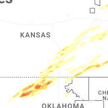
Kansas
| Local Time | Report Details |
|---|---|
| 1:59 PM CDT | Ping Pong Ball sized hail reported near Valley Center, KS, 10.2 miles NNW of Wichita, KS |
| 2:20 PM CDT | Ping Pong Ball sized hail reported near Whitewater, KS, 20.9 miles NNE of Wichita, KS, pea to ping pong ball sized hail. |
| 2:23 PM CDT | Quarter sized hail reported near Whitewater, KS, 21.4 miles NNE of Wichita, KS, relayed from local fire department. |
| 2:29 PM CDT | Quarter sized hail reported near Valley Falls, KS, 48.8 miles WNW of Kansas City, MO |
| 2:36 PM CDT | Quarter sized hail reported near Wichita, KS, 6.3 miles WSW of Wichita, KS, mostly pea to penny sized hail with a couple of quarter sized pieces. |
| 2:43 PM CDT | Quarter sized hail reported near Wichita, KS, 6 miles WNW of Wichita, KS |
| 2:45 PM CDT | Quarter sized hail reported near Burns, KS, 37 miles NE of Wichita, KS |
| 2:52 PM CDT | Half Dollar sized hail reported near Wichita, KS, 7.4 miles NE of Wichita, KS, half dollar hail via mping. |
| 3:00 PM CDT | Half Dollar sized hail reported near Benton, KS, 14.3 miles ENE of Wichita, KS |
| 3:00 PM CDT | Quarter sized hail reported near Benton, KS, 13.2 miles NE of Wichita, KS |
| 3:02 PM CDT | Half Dollar sized hail reported near Conway Springs, KS, 26.4 miles SW of Wichita, KS |
| 3:06 PM CDT | Quarter sized hail reported near Towanda, KS, 21.1 miles ENE of Wichita, KS |
| 3:08 PM CDT | Quarter sized hail reported near Atchison, KS, 42.7 miles NW of Kansas City, MO, social media report. time estimated from radar. |
| 3:09 PM CDT | Quarter sized hail reported near Cedar Vale, KS, 61.3 miles SE of Wichita, KS, ground covered in peas with quarter size hail mixed in. |
| 3:09 PM CDT | Estimated gusts 60-70mp in chautauqua county KS, 61.3 miles SE of Wichita, KS |
| 3:20 PM CDT | Personal weather statio in osage county KS, 50.7 miles ESE of Manhattan, KS |
| 3:33 PM CDT | Quarter sized hail reported near Haysville, KS, 11.5 miles S of Wichita, KS |
| 3:38 PM CDT | Quarter sized hail reported near Derby, KS, 10.3 miles SSE of Wichita, KS |
| 3:41 PM CDT | Golf Ball sized hail reported near Derby, KS, 10.6 miles SSE of Wichita, KS, golf ball sized hail sent via mping. |
| 3:47 PM CDT | Quarter sized hail reported near Atchison, KS, 37.4 miles NW of Kansas City, MO |
| 3:54 PM CDT | Quarter sized hail reported near Derby, KS, 11.7 miles SE of Wichita, KS |
| 3:55 PM CDT | Personal weather statio in coffey county KS, 46.8 miles NW of Chanute, KS |
| 3:57 PM CDT | Quarter sized hail reported near Bluff City, KS, 52 miles SW of Wichita, KS |
| 3:59 PM CDT | Half Dollar sized hail reported near Mayfield, KS, 31.7 miles SSW of Wichita, KS |
| 4:05 PM CDT | Tree damag in coffey county KS, 55.5 miles NNW of Chanute, KS |
| 4:08 PM CDT | Damage reported to outbuildings around olive in osage county KS, 57.4 miles NNW of Chanute, KS |
| 4:15 PM CDT | Tree damage. time estimated from radar dat in coffey county KS, 49.6 miles N of Chanute, KS |
| 4:24 PM CDT | Personal weather statio in franklin county KS, 53.7 miles N of Chanute, KS |
| 4:25 PM CDT | With pea size hail. time estimated from radar dat in franklin county KS, 59.1 miles SW of Kansas City, MO |
| 4:28 PM CDT | Quarter sized hail reported near Thayer, KS, 14 miles S of Chanute, KS |
| 4:35 PM CDT | Kowi. time estimated from radar dat in franklin county KS, 52.9 miles SW of Kansas City, MO |
| 4:41 PM CDT | Estimated 60-65 mph wind gust in franklin county KS, 50.3 miles SW of Kansas City, MO |
| 4:46 PM CDT | Downed wires and power outages near everett avenue. time estimated from rada in wyandotte county KS, 3.3 miles WNW of Kansas City, MO |
| 4:48 PM CDT | Downed wires near pressonville road. time estimated from rada in miami county KS, 40.2 miles SW of Kansas City, MO |
| 4:48 PM CDT | Quarter sized hail reported near Ottawa, KS, 43.1 miles SW of Kansas City, MO |
| 4:54 PM CDT | Several reports of downed wires and power outages in the osawatomie area. time estimated from rada in miami county KS, 46.1 miles SSW of Kansas City, MO |
| 5:02 PM CDT | Photos of large limbs and branches down from socail medi in johnson county KS, 28.1 miles SSW of Kansas City, MO |
| 5:02 PM CDT | Collapsed garage at residence near block road. time estimated from rada in miami county KS, 32.9 miles SSW of Kansas City, MO |
| 5:04 PM CDT | Storm damage reported in miami county KS, 29.6 miles SSW of Kansas City, MO |
| 5:06 PM CDT | Em reports 20 power poles snapped around 223rd and quivira. time estimated from rada in miami county KS, 27.4 miles SSW of Kansas City, MO |
| 5:06 PM CDT | Downed limbs and wires near 77th street. time estimated from rada in johnson county KS, 10.7 miles SW of Kansas City, MO |
| 5:06 PM CDT | Downed limbs and wires near lackman road. time estimated from rada in miami county KS, 28.7 miles SSW of Kansas City, MO |
| 5:06 PM CDT | Downed limbs near 119th and pflumm. time estimated from rada in johnson county KS, 15.8 miles SSW of Kansas City, MO |
| 5:07 PM CDT | Quarter sized hail reported near Hepler, KS, 26.5 miles E of Chanute, KS |
| 5:08 PM CDT | Downed wires and power outages near 36th street. time estimated from rada in wyandotte county KS, 5.9 miles SW of Kansas City, MO |
| 5:10 PM CDT | Several power poles snapped near 223rd and quivira. time estimated from rada in miami county KS, 27.4 miles SSW of Kansas City, MO |
| 5:10 PM CDT | Multiple reports of tree limbs and wires down and very strong winds near 223rd and u.s. 69. time estimated from rada in miami county KS, 26.9 miles S of Kansas City, MO |
| 5:10 PM CDT | Downed tree limbs and wires near 89th terrace. time estimated from rada in johnson county KS, 10.1 miles SSW of Kansas City, MO |
| 5:12 PM CDT | Quarter sized hail reported near Atlanta, KS, 30.7 miles SE of Wichita, KS |
| 5:15 PM CDT | Multiple trees down near 223rd street and state line road. time estimated from rada in miami county KS, 26.5 miles S of Kansas City, MO |
| 5:18 PM CDT | 3 inch round tree limbs across roadway. time estimated based on rada in cowley county KS, 40.6 miles ESE of Wichita, KS |
| 5:19 PM CDT | Downed tree limbs and wires near craig street. time confirmed from rada in johnson county KS, 11.2 miles SSW of Kansas City, MO |
| 5:29 PM CDT | Downed wires near 100th terrace. time confirmed from rada in jackson county MO, 11.3 miles S of Kansas City, MO |
| 6:06 PM CDT | Downed wires near massey lane. time estimated from rada in linn county KS, 46.9 miles NE of Chanute, KS |
| 6:15 PM CDT | Downed wires near 1250th road. time estimated from rada in linn county KS, 57.8 miles NE of Chanute, KS |
| 6:18 PM CDT | Downed wires near 200th road. time estimated from rada in linn county KS, 48.3 miles ENE of Chanute, KS |
Wisconsin
| Local Time | Report Details |
|---|---|
| 2:14 PM CDT | Quarter sized hail reported near Ellsworth, WI, 44 miles ESE of Minneapolis, MN |
| 2:39 PM CDT | Quarter sized hail reported near Superior, WI, 9.4 miles SSE of Duluth, MN, report from mping. |
| 2:45 PM CDT | Quarter sized hail reported near Stanley, WI, 84.6 miles WSW of Rhinelander, WI |
| 2:47 PM CDT | Half Dollar sized hail reported near Ellsworth, WI, 45.5 miles ESE of Minneapolis, MN, emailed photos of large hail in backyard. time estimated via radar. |
| 3:16 PM CDT | Quarter sized hail reported near Tomah, WI, 39.5 miles ENE of La Crosse, WI |
| 3:20 PM CDT | Trees snapped around six feet above the ground between earl and springbrook via photos relayed to nws. time estimated from rada in washburn county WI, 62.4 miles SSE of Duluth, MN |
| 3:28 PM CDT | Mesonet station mrzw3 minong raws. time of wind gust estimated from rada in washburn county WI, 45.1 miles S of Duluth, MN |
| 3:35 PM CDT | Hayward laundry on dakota ave had its roof torn off by the wind. no injuries reporte in sawyer county WI, 61.1 miles SSE of Duluth, MN |
| 3:50 PM CDT | Nevers road reported impassable with photos of trees completely blocking the road. several trees also damaged at corner of nevers road and highway 1 in bayfield county WI, 56.9 miles E of Duluth, MN |
| 3:55 PM CDT | Many branches down approximately 2 inches in diameter. this was from dead wood. time approximated from rada in bayfield county WI, 52.3 miles ESE of Duluth, MN |
| 3:55 PM CDT | Numerous reports of several tall pine trees uprooted in washburn including several that blocked highway 1 in bayfield county WI, 58 miles E of Duluth, MN |
| 3:58 PM CDT | Report of numerous trees down in the vicinity of fish creek hill on old us 2. some trees were likely tall pine trees. location is approximat in bayfield county WI, 52.1 miles ESE of Duluth, MN |
| 4:07 PM CDT | Quarter sized hail reported near Dodgeville, WI, 38.4 miles WSW of Madison, WI, time estimated from radar. |
| 4:15 PM CDT | Awos station k4r5 la pointe airpor in ashland county WI, 63.1 miles E of Duluth, MN |
| 4:19 PM CDT | Quarter sized hail reported near Hayward, WI, 74.7 miles SE of Duluth, MN, quarter size hail 25 e of hayward by moose lake. location is approximate. |
| 4:29 PM CDT | Numerous tree damag in jackson county WI, 51.1 miles N of La Crosse, WI |
| 4:30 PM CDT | Quarter sized hail reported near Winter, WI, 79.9 miles SE of Duluth, MN, this is a correction for a report at this location issued at 0503 pm for quarter size hail. updated to correct time and description. quarter size hail was reported at t |
| 4:58 PM CDT | Quarter sized hail reported near Butternut, WI, 58.4 miles WNW of Rhinelander, WI, law enforcement reported quarter size hail about 5 miles west of park falls near animal rescue. location and time approximate from radar. |
| 5:01 PM CDT | Half Dollar sized hail reported near Hayward, WI, 67.5 miles SSE of Duluth, MN, largest hail was half-dollar size with lots of smaller hail. |
| 5:02 PM CDT | Quarter sized hail reported near Darlington, WI, 53.6 miles WSW of Madison, WI, report from mping: quarter (1.00 in.). |
| 5:03 PM CDT | Quarter sized hail reported near Winter, WI, 79.9 miles SE of Duluth, MN, dime size hail with a few up to quarter size. |
| 5:03 PM CDT | Quarter sized hail reported near Park Falls, WI, 61.8 miles WNW of Rhinelander, WI, dime size hail with a few up to quarters. |
| 5:08 PM CDT | Quarter sized hail reported near Monroe, WI, 41.3 miles SSW of Madison, WI, report from mping: quarter (1.00 in.). |
| 5:16 PM CDT | Golf Ball sized hail reported near Beloit, WI, 42.5 miles SSE of Madison, WI, relayed from broadcast media (wmtv madison). time estimated from radar. |
| 5:20 PM CDT | Ping Pong Ball sized hail reported near Monroe, WI, 35.7 miles SSW of Madison, WI |
| 5:29 PM CDT | Hen Egg sized hail reported near Beloit, WI, 43 miles SSE of Madison, WI |
| 5:30 PM CDT | Baseball sized hail reported near Monroe, WI, 35.1 miles SSW of Madison, WI, relayed from broadcast media (wisc). |
| 5:41 PM CDT | Quarter sized hail reported near Evansville, WI, 26.1 miles SSE of Madison, WI |
| 5:42 PM CDT | Quarter sized hail reported near Watertown, WI, 34.7 miles ENE of Madison, WI |
| 5:42 PM CDT | Barn wall blown down in richwood... w in dodge county WI, 32.8 miles ENE of Madison, WI |
| 6:12 PM CDT | Ping Pong Ball sized hail reported near Janesville, WI, 32.6 miles SE of Madison, WI, time estimated from radar. |
| 6:23 PM CDT | Golf Ball sized hail reported near Milton, WI, 30 miles SE of Madison, WI |
| 7:02 PM CDT | Quarter sized hail reported near Eagle, WI, 45.1 miles ESE of Madison, WI |
| 7:12 PM CDT | Quarter sized hail reported near Eagle, WI, 48.3 miles ESE of Madison, WI, relayed from ham radio. |
| 7:22 PM CDT | Social media report of uprooted tree in east troy... wi. time estimated on rada in walworth county WI, 53.7 miles ESE of Madison, WI |
| 7:25 PM CDT | Quarter sized hail reported near Eagle, WI, 49 miles ESE of Madison, WI |
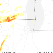
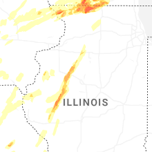
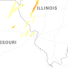
Illinois
| Local Time | Report Details |
|---|---|
| 2:51 PM CDT | Half Dollar sized hail reported near Galena, IL, 69.3 miles SW of Madison, WI, report from mping: half dollar (1.25 in.). |
| 2:52 PM CDT | Ping Pong Ball sized hail reported near Galena, IL, 68.6 miles SW of Madison, WI, report from mping: ping pong ball (1.50 in.). |
| 2:54 PM CDT | Ping Pong Ball sized hail reported near Galena, IL, 69.1 miles SW of Madison, WI, report from mping: ping pong ball (1.50 in.). |
| 2:55 PM CDT | Golf Ball sized hail reported near Hanover, IL, 69.6 miles ENE of Cedar Rapids, IA |
| 2:57 PM CDT | Golf Ball sized hail reported near Galena, IL, 68.3 miles SW of Madison, WI, report from mping: golf ball (1.75 in.). |
| 2:57 PM CDT | Golf Ball sized hail reported near Galena, IL, 68.6 miles SW of Madison, WI, report from mping: golf ball (1.75 in.). |
| 2:59 PM CDT | Golf Ball sized hail reported near Galena, IL, 68.4 miles SW of Madison, WI, report from mping: golf ball (1.75 in.). |
| 3:00 PM CDT | Quarter sized hail reported near Galena, IL, 66.1 miles SW of Madison, WI, report from mping: quarter (1.00 in.). |
| 3:00 PM CDT | Several branches down ranging from 2-4 inches in diameter. many yard items also displace in jo daviess county IL, 69.2 miles SW of Madison, WI |
| 3:01 PM CDT | Golf Ball sized hail reported near Hanover, IL, 68.4 miles SW of Madison, WI, report from mping: golf ball (1.75 in.). |
| 3:05 PM CDT | Ping Pong Ball sized hail reported near Hanover, IL, 72.5 miles SW of Madison, WI |
| 3:13 PM CDT | Golf Ball sized hail reported near Elizabeth, IL, 67.6 miles SW of Madison, WI |
| 3:26 PM CDT | Wind out of the wes in jo daviess county IL, 51.1 miles SW of Madison, WI |
| 3:30 PM CDT | Half Dollar sized hail reported near Elizabeth, IL, 67.1 miles SW of Madison, WI |
| 3:45 PM CDT | Photos show structural damage to houses. relayed via social media. tornado possibl in stephenson county IL, 52.9 miles SSW of Madison, WI |
| 3:49 PM CDT | 3ft tree down at the bas in jo daviess county IL, 55.7 miles SSW of Madison, WI |
| 3:50 PM CDT | Quarter sized hail reported near Lena, IL, 52 miles SSW of Madison, WI, time estimated by radar. |
| 3:58 PM CDT | Roof damage at the high schoo in pike county IL, 66.6 miles NNW of Saint Louis, MO |
| 3:58 PM CDT | Roof damage at the high schoo in pike county IL, 66.6 miles NNW of Saint Louis, MO |
| 3:58 PM CDT | Report of tree damage and lots of limbs snappe in pike county IL, 66.9 miles NNW of Saint Louis, MO |
| 4:12 PM CDT | Large tree... roughly 2 feet in diameter down with root ball expose in pike county IL, 74.3 miles SE of Kahoka, MO |
| 4:15 PM CDT | Storm damage reported in pike county IL, 73.4 miles SE of Kahoka, MO |
| 4:15 PM CDT | Several reports of tree damage with large limbs snappe in pike county IL, 73.5 miles SE of Kahoka, MO |
| 4:18 PM CDT | Golf Ball sized hail reported near Rock City, IL, 42.6 miles S of Madison, WI, report from mping: golf ball (1.75 in.). |
| 4:22 PM CDT | Storm damage reported in scott county IL, 65.4 miles NNW of Saint Louis, MO |
| 4:24 PM CDT | A few commercial and residential buildings were damage in scott county IL, 70.3 miles N of Saint Louis, MO |
| 4:24 PM CDT | Il-106 at woodson-winchester blacktop due to downed power line in scott county IL, 70.2 miles N of Saint Louis, MO |
| 4:24 PM CDT | Tea Cup sized hail reported near Freeport, IL, 48.7 miles S of Madison, WI, report from mping: tea cup (3.00 in.). |
| 4:24 PM CDT | Report of tree damage in griggsville... i in pike county IL, 71.8 miles SE of Kahoka, MO |
| 4:24 PM CDT | Golf Ball sized hail reported near Dakota, IL, 47.7 miles S of Madison, WI |
| 4:25 PM CDT | Quarter sized hail reported near Freeport, IL, 52.8 miles S of Madison, WI, report from mping: quarter (1.00 in.). |
| 4:26 PM CDT | Quarter sized hail reported near Freeport, IL, 51.1 miles S of Madison, WI, report from mping: quarter (1.00 in.). |
| 4:29 PM CDT | Golf Ball sized hail reported near Freeport, IL, 51.1 miles S of Madison, WI, report from mping: golf ball (1.75 in.). |
| 4:32 PM CDT | Quarter sized hail reported near Stockton, IL, 55.7 miles SSW of Madison, WI, photos relayed via social media. |
| 4:38 PM CDT | Hen Egg sized hail reported near Pecatonica, IL, 50.6 miles S of Madison, WI, photo shows hail estimated as approximately 2 inches in diameter near pecatonica. location estimated... relayed by broadcast media. time estimated by radar. |
| 4:40 PM CDT | A 60’x 40’ shed destroyed just south of chapin. time estimated by rada in morgan county IL, 77.3 miles SW of Peoria, IL |
| 4:40 PM CDT | Hen Egg sized hail reported near Davis, IL, 43 miles S of Madison, WI |
| 4:41 PM CDT | Hen Egg sized hail reported near Davis, IL, 40.9 miles S of Madison, WI, time estimated by radar. relayed via mping. |
| 4:41 PM CDT | Half Dollar sized hail reported near Durand, IL, 45.1 miles S of Madison, WI, report from mping: half dollar (1.25 in.). |
| 4:43 PM CDT | Golf Ball sized hail reported near Durand, IL, 45.2 miles S of Madison, WI, hail of at least golf ball size ongoing on south side of durand. |
| 4:44 PM CDT | Hen Egg sized hail reported near Durand, IL, 45.2 miles S of Madison, WI, hen egg size hail south of durand. relayed via mping. |
| 4:45 PM CDT | Baseball sized hail reported near Dakota, IL, 47.7 miles S of Madison, WI, report from lot on dakota storm.. they received a photo of baseball size hail.. |
| 4:48 PM CDT | Multiple farm buildings were flattened and the roofs of a couple machine sheds were torn of in schuyler county IL, 67.6 miles SW of Peoria, IL |
| 4:48 PM CDT | Golf Ball sized hail reported near Durand, IL, 41.3 miles S of Madison, WI, relayed via mping. time estimated by radar. |
| 4:54 PM CDT | Several trees and tree branches were blown down along sugar grove road and at us-67 and watchtower road. the entire town of rushville has lost powe in schuyler county IL, 65.2 miles ESE of Kahoka, MO |
| 4:59 PM CDT | Golf Ball sized hail reported near Rushville, IL, 61.8 miles SW of Peoria, IL |
| 4:59 PM CDT | Storm damage reported in schuyler county IL, 61.8 miles SW of Peoria, IL |
| 5:00 PM CDT | Us 67 closure due to tree damage near us 67 and bluff roa in schuyler county IL, 64.7 miles SW of Peoria, IL |
| 5:02 PM CDT | Trained spotter reports damage to a structure near bates road and favor road southeast of harrison. possible tornado. time estimated by rada in winnebago county IL, 47.9 miles SSE of Madison, WI |
| 5:06 PM CDT | Quarter sized hail reported near Rockton, IL, 44.4 miles SSE of Madison, WI, relayed via mping. |
| 5:09 PM CDT | Damage to trees and a structure observed along owen center road southwest of rockton. possible tornado. time estimated by rada in winnebago county IL, 46.4 miles SSE of Madison, WI |
| 5:09 PM CDT | Quarter sized hail reported near Astoria, IL, 51.7 miles SW of Peoria, IL |
| 5:14 PM CDT | Ping Pong Ball sized hail reported near South Beloit, IL, 43.9 miles SSE of Madison, WI, relayed via mping. time estimated by radar. |
| 5:16 PM CDT | Half Dollar sized hail reported near South Beloit, IL, 43.9 miles SSE of Madison, WI, report from mping: half dollar (1.25 in.). |
| 5:16 PM CDT | Hen Egg sized hail reported near Ipava, IL, 45.2 miles WSW of Peoria, IL, spotter reported hail measured at 60mm... or 2.36 inch. |
| 5:16 PM CDT | An industrial building has broken window in fulton county IL, 44.3 miles WSW of Peoria, IL |
| 5:16 PM CDT | Ping Pong Ball sized hail reported near Ipava, IL, 45.7 miles WSW of Peoria, IL |
| 5:20 PM CDT | Ping Pong Ball sized hail reported near South Beloit, IL, 43.9 miles SSE of Madison, WI, report from mping: ping pong ball (1.50 in.). |
| 5:22 PM CDT | Quarter sized hail reported near Smithfield, IL, 43.2 miles WSW of Peoria, IL |
| 5:41 PM CDT | Quarter sized hail reported near Fairview, IL, 30.4 miles W of Peoria, IL |
| 5:41 PM CDT | Quarter sized hail reported near Farmington, IL, 27.3 miles W of Peoria, IL |
| 5:57 PM CDT | Several tree branches were blown down near the intersection of south knox and main street in elmwoo in peoria county IL, 21 miles WNW of Peoria, IL |
| 6:01 PM CDT | Reports of farm debris scattered about the fiel in knox county IL, 27.4 miles WNW of Peoria, IL |
| 6:03 PM CDT | Flipped farm trailer... trees snapped... and several power poles snapped. there was also a semi flipped on i-7 in knox county IL, 27.4 miles WNW of Peoria, IL |
| 6:05 PM CDT | 3 power poles snappe in knox county IL, 26 miles WNW of Peoria, IL |
| 6:07 PM CDT | Tree snappe in knox county IL, 27.2 miles NW of Peoria, IL |
| 6:10 PM CDT | Quarter sized hail reported near Laura, IL, 23.9 miles NW of Peoria, IL |
| 6:10 PM CDT | Ping Pong Ball sized hail reported near Williamsfield, IL, 29.2 miles NW of Peoria, IL |
| 6:10 PM CDT | Half Dollar sized hail reported near Laura, IL, 25.6 miles NW of Peoria, IL |
| 6:11 PM CDT | 3-4 inch branch across the road just east of the 97 and 8 junctio in knox county IL, 30.1 miles WNW of Peoria, IL |
| 6:13 PM CDT | Multiple downed tree branches... including some up to 3 inches thick. portapotty blown over. time estimated from rada in mercer county IL, 64 miles NE of Kahoka, MO |
| 6:15 PM CDT | Sheet metal barn had a roof ripped of in stark county IL, 28.9 miles NW of Peoria, IL |
| 6:18 PM CDT | Storm damage reported in hancock county IL, 32.2 miles ENE of Kahoka, MO |
| 6:25 PM CDT | Hen Egg sized hail reported near Toulon, IL, 30.9 miles NNW of Peoria, IL, photo shared on social media. |
| 6:28 PM CDT | Storm damage reported in carroll county IL, 66 miles SSW of Madison, WI |
| 6:36 PM CDT | Part of a brick facade on a building collapsed. branches downed to in mercer county IL, 63.5 miles NW of Peoria, IL |
| 6:40 PM CDT | Reported 60 mph winds for 20 minutes along with tree limb damage. time estimated by rada in warren county IL, 61.2 miles WNW of Peoria, IL |
| 6:47 PM CDT | Powerpole broke in bureau county IL, 46.5 miles N of Peoria, IL |
| 6:54 PM CDT | Home damaged. possible tornad in hancock county IL, 28.1 miles ESE of Kahoka, MO |
| 6:54 PM CDT | Storm damage reported in whiteside county IL, 82.6 miles NNW of Peoria, IL |
| 6:59 PM CDT | Storm damage reported in hancock county IL, 21.9 miles E of Kahoka, MO |
| 6:59 PM CDT | Storm damage reported in henry county IL, 63 miles NNW of Peoria, IL |
| 6:59 PM CDT | Farm equipment blown into ditch from an embankment. time estimated from rada in hancock county IL, 34.1 miles ESE of Kahoka, MO |
| 7:00 PM CDT | Tree limbs snapped and sheet metal roof blown off a machine shed. time estimated by rada in hancock county IL, 36 miles ESE of Kahoka, MO |
| 7:09 PM CDT | Multiple structures with roof damage near roscoe road and leena drive in roscoe. possible tornado. time estimated by rada in winnebago county IL, 48.9 miles SSE of Madison, WI |
| 7:12 PM CDT | Tree blown dow in mcdonough county IL, 43.7 miles ESE of Kahoka, MO |
| 7:12 PM CDT | Large grain elevator bins destroyed damaging train crossing gate in mcdonough county IL, 44 miles E of Kahoka, MO |
| 7:13 PM CDT | Photo shows multiple large branches broken and blocking a roadway near mcdonald road and double ditch circle in roscoe. relayed by social media. possible tornado. time in winnebago county IL, 50.2 miles SSE of Madison, WI |
| 7:13 PM CDT | Several large trees damaged south west of belvidere road and main street in roscoe. relayed by amateur radio. time estimated by radar. possible tornad in winnebago county IL, 49.6 miles SSE of Madison, WI |
| 7:20 PM CDT | Structure damage in mcdonough county IL, 47.4 miles E of Kahoka, MO |
| 7:28 PM CDT | Golf Ball sized hail reported near Toulon, IL, 30.9 miles NNW of Peoria, IL, siding was damaged by the hail. |
| 7:31 PM CDT | Power poles dow in mcdonough county IL, 58.3 miles E of Kahoka, MO |
| 7:33 PM CDT | Numerous power poles were snapped along north 7 hills roa in fulton county IL, 43.3 miles W of Peoria, IL |
| 7:35 PM CDT | Quincy regiona in adams county IL, 43.1 miles SE of Kahoka, MO |
| 7:45 PM CDT | Numerous trees were blown dow in fulton county IL, 45.2 miles WSW of Peoria, IL |
| 7:49 PM CDT | 63 mph gust near alden road and il-173. relayed via amateur radio. time estimated by rada in mchenry county IL, 60.5 miles NW of Chicago, IL |
| 7:52 PM CDT | Tree blown dow in bureau county IL, 41.5 miles N of Peoria, IL |
| 7:54 PM CDT | Rockford asos krfd gusted 62 mp in winnebago county IL, 62 miles SSE of Madison, WI |
| 7:56 PM CDT | Storm damage reported in fulton county IL, 36.2 miles WSW of Peoria, IL |
| 8:01 PM CDT | A trained spotter measured a 58 mp in putnam county IL, 41.6 miles NNE of Peoria, IL |
| 8:09 PM CDT | Private weather station kilgarde2 recorded 61 mph gus in boone county IL, 60.5 miles WNW of Chicago, IL |
| 8:10 PM CDT | Il dot station on harmony road west of riley recorded 76 mph wind gus in mchenry county IL, 58.1 miles WNW of Chicago, IL |
| 8:10 PM CDT | Multiple trees blown dow in bureau county IL, 48.5 miles NNE of Peoria, IL |
| 8:11 PM CDT | Trees were blown dow in fulton county IL, 26.1 miles SW of Peoria, IL |
| 8:15 PM CDT | Trees and power lines were blown down across duncheon roa in menard county IL, 43 miles SSW of Peoria, IL |
| 8:18 PM CDT | A pole barn was severely damaged southwest of mendota with large portions of siding removed and partial structural collapse. time estimated using rada in la salle county IL, 59.2 miles NNE of Peoria, IL |
| 8:25 PM CDT | Several semi trucks were overturned on i-39 east of mendota. time estimated using rada in la salle county IL, 65.3 miles NNE of Peoria, IL |
| 8:26 PM CDT | Power lines were blown dow in logan county IL, 26.4 miles S of Peoria, IL |
| 8:31 PM CDT | Storm damage reported in mcdonough county IL, 53.9 miles E of Kahoka, MO |
| 8:33 PM CDT | Storm damage reported in tazewell county IL, 4.4 miles SSE of Peoria, IL |
| 8:37 PM CDT | Storm damage reported in woodford county IL, 22.2 miles NE of Peoria, IL |
| 8:38 PM CDT | Power lines were blown across jefferson stree in tazewell county IL, 9.2 miles SE of Peoria, IL |
| 8:46 PM CDT | A semi was blown over on i-74 near mile marker 10 in woodford county IL, 14.9 miles ESE of Peoria, IL |
| 8:50 PM CDT | A tree was blown down across gillett stree in logan county IL, 46.7 miles S of Peoria, IL |
| 8:51 PM CDT | Corrects previous tstm wnd dmg report from 2 nw sandwich. report of a two foot diameter tree trunk down and blocking the southbound lane of somonauk rd just north of pr in de kalb county IL, 55.1 miles WSW of Chicago, IL |
| 8:53 PM CDT | Multiple trees and power lines were blown dow in mclean county IL, 25.3 miles ESE of Peoria, IL |
| 8:55 PM CDT | Numerous trees and power lines were blown down along west market stree in mclean county IL, 32 miles ESE of Peoria, IL |
| 8:57 PM CDT | The roof and some of the walls of a new building at the rivian manufacturing center collapse in mclean county IL, 30.5 miles ESE of Peoria, IL |
| 8:57 PM CDT | A power pole was snapped along il-251 just north of its intersection with il-11 in woodford county IL, 31.7 miles ENE of Peoria, IL |
| 8:57 PM CDT | Storm damage reported in woodford county IL, 32.6 miles ENE of Peoria, IL |
| 9:00 PM CDT | Power poles were snapped along ge roa in mclean county IL, 36.1 miles ESE of Peoria, IL |
| 9:00 PM CDT | A large tree was blown over on livingston stree in mclean county IL, 33.4 miles ESE of Peoria, IL |
| 9:00 PM CDT | A large tree was blown down onto a parked car. chunks of shingles and gutters were blown off structure in mclean county IL, 37.1 miles ESE of Peoria, IL |
| 9:05 PM CDT | Numerous power poles were snapped along college avenue and near the intersection of south main street and east lincoln stree in mclean county IL, 34.3 miles ESE of Peoria, IL |
| 9:05 PM CDT | Significant tree damage across much of north norma in mclean county IL, 34.1 miles ESE of Peoria, IL |
| 9:05 PM CDT | Power poles were blown dow in mclean county IL, 42.8 miles ESE of Peoria, IL |
| 9:06 PM CDT | Wind gust measured with anemomete in mclean county IL, 34.3 miles ESE of Peoria, IL |
| 9:06 PM CDT | A home was heavily damage in mclean county IL, 42.8 miles ESE of Peoria, IL |
| 9:08 PM CDT | A large tree limb was blown down onto il-54 one mile east of the logan/dewitt county lin in de witt county IL, 48.7 miles SSE of Peoria, IL |
| 9:16 PM CDT | Power lines reported down causing trees to catch fire at kirk rd and il-38 in geneva. time estimated by rada in kane county IL, 33.4 miles W of Chicago, IL |
| 9:16 PM CDT | Top half of a tree down in the road at il rt. 31 and fabian pkwy in batavia. time estimated by rada in kane county IL, 35 miles W of Chicago, IL |
| 9:17 PM CDT | A personal weather station recorded a 66 mph gust south of marseille in la salle county IL, 61.4 miles NE of Peoria, IL |
| 9:18 PM CDT | Two barns were destroye in mclean county IL, 52 miles E of Peoria, IL |
| 9:28 PM CDT | Missing roof and barn destroyed. possible tornado. time estimated from rada in fulton county IL, 37.5 miles WSW of Peoria, IL |
| 9:28 PM CDT | Power line dow in mclean county IL, 58.5 miles E of Peoria, IL |
| 9:30 PM CDT | Structure damage was reported around parts of gibson city... including one business which had large portions of metal siding ripped off. tree damage was also reported i in ford county IL, 65.4 miles ESE of Peoria, IL |
| 9:40 PM CDT | A grain bin was blown into a ditch and several power lines were downe in tazewell county IL, 16.8 miles SE of Peoria, IL |
| 9:42 PM CDT | Storm damage reported in macon county IL, 35.3 miles NW of Mattoon, IL |
| 9:42 PM CDT | Power pole dow in piatt county IL, 41.6 miles NNW of Mattoon, IL |
| 9:49 PM CDT | Report of an eight inch diameter tree branch broken off of a tree near the intersection of oak st and american st in paxton. time estimated by rada in ford county IL, 69.8 miles NNE of Mattoon, IL |
| 9:49 PM CDT | Grain bins were destroyed in loda. exact location unknown. time estimated using rada in iroquois county IL, 73.5 miles NNE of Mattoon, IL |
| 9:50 PM CDT | A personal weather station recorded a 65 mph gust south of buckingha in kankakee county IL, 65.8 miles SSW of Chicago, IL |
| 9:51 PM CDT | Report of semi trucks blown over on i-57 near mile marker 270 southwest of buckley. time estimated using rada in iroquois county IL, 78.3 miles NNE of Mattoon, IL |
| 9:52 PM CDT | A power pole was leaning over near route 47 just east of seymou in champaign county IL, 43.4 miles N of Mattoon, IL |
| 10:03 PM CDT | A large tree was snapped on broadway avenu in champaign county IL, 44.2 miles NNE of Mattoon, IL |
| 10:04 PM CDT | Storm damage reported in champaign county IL, 38.9 miles N of Mattoon, IL |
| 10:06 PM CDT | A personal weather station recorded a 61 mph gust west of watsek in iroquois county IL, 80.9 miles S of Chicago, IL |
| 10:08 PM CDT | A personal weather station recorded a 62 mph gust in the south loops community area of chicag in cook county IL, 1.8 miles SSE of Chicago, IL |
| 10:08 PM CDT | Storm damage reported in cook county IL, 15.9 miles WSW of Chicago, IL |
| 10:09 PM CDT | Reports of tree damage in the manteno area. time estimated using rada in kankakee county IL, 45.1 miles SSW of Chicago, IL |
| 10:10 PM CDT | Emergency manager recorded a 73 mph wind gust in watseka. time estimated using rada in iroquois county IL, 77.1 miles S of Chicago, IL |
| 10:11 PM CDT | Emergency manager reported extensive tree damage in watseka... particularly around the southeast side of town. numerous uprooted trees and snapped tree trunks were note in iroquois county IL, 77.1 miles S of Chicago, IL |
| 10:12 PM CDT | The harrison-dever crib recorded a 56 kt wind gus in lmz741 county IL, 4.1 miles NE of Chicago, IL |
| 10:15 PM CDT | Measured at an ambient pw in iroquois county IL, 64.8 miles S of Chicago, IL |
| 10:15 PM CDT | Measured at pws watse1 in iroquois county IL, 77 miles S of Chicago, IL |
| 10:31 PM CDT | A personal weather station recorded a 68 mph gust south of dyer just west of the il-in state lin in will county IL, 34.5 miles S of Chicago, IL |
| 10:45 PM CDT | A tree was blown over at il route 1 and moore stree in vermilion county IL, 57.4 miles NE of Mattoon, IL |
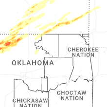
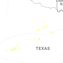
Oklahoma
| Local Time | Report Details |
|---|---|
| 4:00 PM CDT | Half Dollar sized hail reported near Cherokee, OK, 62.3 miles ENE of Woodward, OK, time estimated by radar. |
| 4:33 PM CDT | Quarter sized hail reported near Carmen, OK, 56.9 miles ENE of Woodward, OK, report from mping: quarter (1.00 in.). |
| 4:35 PM CDT | Quarter sized hail reported near Cherokee, OK, 61.1 miles ENE of Woodward, OK |
| 4:40 PM CDT | Golf Ball sized hail reported near Cherokee, OK, 63.8 miles ENE of Woodward, OK |
| 4:42 PM CDT | Tea Cup sized hail reported near Jet, OK, 66 miles ENE of Woodward, OK, corrects previous time from 4 w jet. estimated size looks to be closer to 3.25 inches. |
| 4:42 PM CDT | Hen Egg sized hail reported near Cherokee, OK, 62.7 miles ENE of Woodward, OK |
| 4:44 PM CDT | Quarter sized hail reported near Carmen, OK, 56.9 miles ENE of Woodward, OK, report from mping: quarter (1.00 in.). |
| 4:45 PM CDT | Hen Egg sized hail reported near Dacoma, OK, 47.4 miles ENE of Woodward, OK |
| 4:47 PM CDT | Golf Ball sized hail reported near Chester, OK, 27.7 miles ESE of Woodward, OK, nssl employee. |
| 4:47 PM CDT | Quarter sized hail reported near Fairview, OK, 27.9 miles ESE of Woodward, OK |
| 4:51 PM CDT | Ping Pong Ball sized hail reported near Fairview, OK, 27.9 miles ESE of Woodward, OK, report from mping: ping pong ball (1.50 in.). |
| 4:52 PM CDT | Baseball sized hail reported near Cherokee, OK, 62 miles ENE of Woodward, OK |
| 4:53 PM CDT | Hen Egg sized hail reported near Jet, OK, 73.9 miles ENE of Woodward, OK |
| 4:53 PM CDT | Tennis Ball sized hail reported near Cherokee, OK, 57.8 miles ENE of Woodward, OK |
| 4:58 PM CDT | Golf Ball sized hail reported near Nash, OK, 76.8 miles ENE of Woodward, OK |
| 5:02 PM CDT | Quarter sized hail reported near Waynoka, OK, 37.4 miles E of Woodward, OK, report from mping: quarter (1.00 in.). |
| 5:03 PM CDT | Ping Pong Ball sized hail reported near Waynoka, OK, 37.4 miles E of Woodward, OK, report from mping: ping pong ball (1.50 in.). |
| 5:09 PM CDT | Tea Cup sized hail reported near Jet, OK, 66 miles ENE of Woodward, OK, estimated size looks to be closer to 3.25 inches. |
| 5:29 PM CDT | Golf Ball sized hail reported near Aline, OK, 57 miles E of Woodward, OK |
| 5:30 PM CDT | Half Dollar sized hail reported near Helena, OK, 63.8 miles E of Woodward, OK |
| 5:42 PM CDT | Quarter sized hail reported near Goltry, OK, 69.9 miles E of Woodward, OK, report from mping: quarter (1.00 in.). |
| 5:51 PM CDT | Half Dollar sized hail reported near Hillsdale, OK, 77.5 miles E of Woodward, OK, social media image showing a ruler measurement. |
| 6:09 PM CDT | Quarter sized hail reported near Pond Creek, OK, 74.7 miles SSW of Wichita, KS |
| 6:09 PM CDT | Golf Ball sized hail reported near Pond Creek, OK, 74.7 miles SSW of Wichita, KS, corrects previous hail report from pond creek. social media image showing a ruler measurement. |
| 6:10 PM CDT | Golf Ball sized hail reported near Pond Creek, OK, 74.7 miles SSW of Wichita, KS |
| 6:12 PM CDT | Golf Ball sized hail reported near Pond Creek, OK, 73.8 miles SSW of Wichita, KS |
| 6:22 PM CDT | Tennis Ball sized hail reported near Enid, OK, 69.6 miles NNW of Oklahoma City, OK |
| 6:23 PM CDT | Ping Pong Ball sized hail reported near Enid, OK, 70.9 miles NNW of Oklahoma City, OK |
| 6:24 PM CDT | Hen Egg sized hail reported near Pond Creek, OK, 72.5 miles SSW of Wichita, KS |
| 6:25 PM CDT | Tea Cup sized hail reported near Lamont, OK, 69.9 miles S of Wichita, KS, social media image showing a ruler measurement. time estimated by radar. |
| 6:27 PM CDT | Golf Ball sized hail reported near Kremlin, OK, 76.3 miles NNW of Oklahoma City, OK |
| 6:29 PM CDT | Half Dollar sized hail reported near Lamont, OK, 69.9 miles S of Wichita, KS |
| 6:30 PM CDT | Baseball sized hail reported near Lamont, OK, 69.9 miles S of Wichita, KS |
| 6:37 PM CDT | Tea Cup sized hail reported near Lamont, OK, 69.9 miles S of Wichita, KS |
| 6:46 PM CDT | Quarter sized hail reported near Tonkawa, OK, 68.1 miles S of Wichita, KS |
| 6:48 PM CDT | Quarter sized hail reported near Blackwell, OK, 61.2 miles S of Wichita, KS |
| 6:52 PM CDT | Quarter sized hail reported near Blackwell, OK, 60.5 miles S of Wichita, KS, report from mping: quarter (1.00 in.). |
| 7:01 PM CDT | Hen Egg sized hail reported near Tonkawa, OK, 66 miles S of Wichita, KS |
| 7:04 PM CDT | Minor exterior and interior damage reported at osage casino. possible tornado damage. time estimated from rada in osage county OK, 68.8 miles WNW of Tulsa, OK |
| 7:05 PM CDT | Several trees as well as power lines down and roads blocke in kay county OK, 69.5 miles SSE of Wichita, KS |
| 7:06 PM CDT | Golf Ball sized hail reported near Ponca City, OK, 62.9 miles SSE of Wichita, KS, spotter network report. time estimated by radar. |
| 7:06 PM CDT | Hen Egg sized hail reported near Ponca City, OK, 61.7 miles SSE of Wichita, KS, spotter network report. time estimated by radar. |
| 7:20 PM CDT | Recorded by burbank mesonet statio in osage county OK, 56.4 miles NW of Tulsa, OK |
| 7:23 PM CDT | Golf Ball sized hail reported near Okeene, OK, 63.3 miles NW of Oklahoma City, OK |
| 7:25 PM CDT | Half Dollar sized hail reported near Okeene, OK, 63.3 miles NW of Oklahoma City, OK |
| 7:25 PM CDT | Media chaser showing tree damage in burbank. time estimated from rada in osage county OK, 55.9 miles NW of Tulsa, OK |
| 7:27 PM CDT | Golf Ball sized hail reported near Okeene, OK, 63.3 miles NW of Oklahoma City, OK |
| 8:03 PM CDT | Half Dollar sized hail reported near Taloga, OK, 41.1 miles SE of Woodward, OK, spotter network report. time estimated by radar. |
| 8:15 PM CDT | Ping Pong Ball sized hail reported near Marshall, OK, 47.8 miles N of Oklahoma City, OK |
| 8:16 PM CDT | Tennis Ball sized hail reported near Marshall, OK, 47.8 miles N of Oklahoma City, OK |
| 8:18 PM CDT | Quarter sized hail reported near Cheyenne, OK, 58.8 miles SSW of Woodward, OK |
| 8:18 PM CDT | Tree damage on the west side of bartlesvill in osage county OK, 41.4 miles N of Tulsa, OK |
| 9:15 PM CDT | Corrects previous tstm wnd gst report from 4 ne lovell. ok mesone in logan county OK, 43.5 miles N of Oklahoma City, OK |
| 9:20 PM CDT | Semi overturned on i-3 in payne county OK, 41.7 miles NNE of Oklahoma City, OK |
| 9:23 PM CDT | Ok mesone in logan county OK, 43.5 miles N of Oklahoma City, OK |
| 9:55 PM CDT | Storm damage reported in kiowa county OK, 76.4 miles ENE of Childress, TX |
| 10:35 PM CDT | Storm damage reported in jackson county OK, 51.6 miles ENE of Childress, TX |
| 11:15 PM CDT | Storm damage reported in tillman county OK, 52.3 miles NW of Wichita Falls, TX |
| 11:28 PM CDT | Kfd in tillman county OK, 40.5 miles NW of Wichita Falls, TX |
| 11:46 PM CDT | Quarter sized hail reported near Elgin, OK, 61.4 miles N of Wichita Falls, TX, report from mping: quarter (1.00 in.). |
| 11:50 PM CDT | Storm damage reported in cotton county OK, 34.8 miles NNE of Wichita Falls, TX |
| 11:55 PM CDT | Walters (wal2) mesone in cotton county OK, 35 miles NNE of Wichita Falls, TX |
| 12:00 AM CDT | Kla in comanche county OK, 45.2 miles N of Wichita Falls, TX |
| 1:35 AM CDT | Madill (madi) mesone in marshall county OK, 52.3 miles WSW of Atoka, OK |
Indiana
| Local Time | Report Details |
|---|---|
| 10:25 PM CDT | Newton county ems reported numerous power poles down south of cr 1300s from the il-in state line east to us-41 northwest of kentland. time estimated using rada in newton county IN, 74.5 miles S of Chicago, IL |
| 10:31 PM CDT | Measured at an ambient pw in lake county IN, 34.6 miles S of Chicago, IL |
| 10:45 PM CDT | Numerous powerlines and poles were reported down south of 1300 south from us 41 to state line roa in newton county IN, 76.6 miles S of Chicago, IL |
| 11:07 PM CDT | Measured at an ambient pw in porter county IN, 56.3 miles SE of Chicago, IL |
| 12:45 AM EDT | Emergency manager reported approximately 5 utility poles snapped at ground level on sr-8 between union and upas roads in marshall county in indian in marshall county IN, 72 miles WNW of Fort Wayne, IN |
| 12:46 AM EDT | Emergency manager reported multiple trees down across the roadway west of plymouth in marshall county... indian in marshall county IN, 69 miles WNW of Fort Wayne, IN |
| 12:46 AM EDT | Report of 9 trees dow in st. joseph county IN, 66.4 miles E of Chicago, IL |
| 12:47 AM EDT | Emergency manager reported tree limbs down on powerlines west of plymouth in marshall county... indian in marshall county IN, 67.9 miles WNW of Fort Wayne, IN |
| 12:51 AM EDT | Report on facebook of a tree down blocking portage and adam in st. joseph county IN, 69.4 miles E of Chicago, IL |
| 12:55 AM EDT | Awos station krcr rocheste in fulton county IN, 56.4 miles W of Fort Wayne, IN |
Texas
| Local Time | Report Details |
|---|---|
| 11:00 PM CDT | Storm damage reported in hardeman county TX, 16.7 miles ESE of Childress, TX |
| 11:35 PM CDT | Storm damage reported in hardeman county TX, 16.7 miles ESE of Childress, TX |
| 12:39 AM CDT | Ksp in wichita county TX, 5 miles N of Wichita Falls, TX |
| 5:49 AM CDT | 60 mph gusts measured by a trained spotte in nolan county TX, 42.4 miles SW of Abilene, TX |
Connect with Interactive Hail Maps