

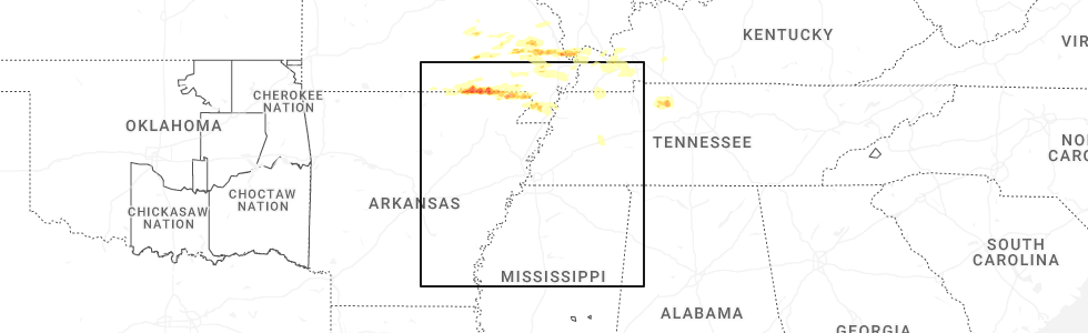
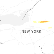
Hail Map for Thursday, April 16, 2026
Number of Impacted Households on 4/16/2026
0
Impacted by 1" or Larger Hail
0
Impacted by 1.75" or Larger Hail
0
Impacted by 2.5" or Larger Hail
Square Miles of Populated Area Impacted on 4/16/2026
0
Impacted by 1" or Larger Hail
0
Impacted by 1.75" or Larger Hail
0
Impacted by 2.5" or Larger Hail

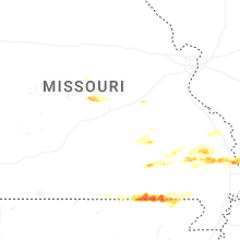
Cities Most Affected by Hail Storms of 4/16/2026
| Hail Size | Demographics of Zip Codes Affected | ||||||
|---|---|---|---|---|---|---|---|
| City | Count | Average | Largest | Pop Density | House Value | Income | Age |
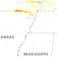
| Iberia, MO | 5 | 2.45 | 3.00 | 25 | $57k | $30.6k | 37.7 |
| Eugene, MO | 2 | 2.50 | 2.50 | 28 | $96k | $41.6k | 38.0 |
| Advance, MO | 2 | 2.38 | 2.75 | 23 | $59k | $29.7k | 42.5 |
| Sanderson, TX | 1 | 2.00 | 2.00 | 0 | $26k | $23.9k | 44.7 |
| Success, AR | 1 | 1.75 | 1.75 | 7 | $28k | $30.6k | 42.9 |
| Mounds, IL | 1 | 1.75 | 1.75 | 52 | $26k | $23.3k | 39.8 |
| Eldon, MO | 1 | 1.75 | 1.75 | 81 | $69k | $30.6k | 40.4 |
| Oran, MO | 1 | 1.75 | 1.75 | 24 | $55k | $29.9k | 40.0 |
| Dixon, MO | 1 | 1.75 | 1.75 | 32 | $72k | $31.3k | 40.3 |
Hail and Wind Damage Spotted on 4/16/2026
Filter by Report Type:Hail ReportsWind Reports
States Impacted
Missouri, Arkansas, Ohio, Pennsylvania, Michigan, Illinois, Kentucky, Tennessee, New York, Texas, New Hampshire, VermontMissouri
| Local Time | Report Details |
|---|---|
| 1:52 PM CDT | Quarter sized hail reported near West Plains, MO, 78.4 miles S of Salem, MO, hail to quarters in size reported. |
| 2:03 PM CDT | Half Dollar sized hail reported near Zalma, MO, 34.4 miles WSW of Cape Girardeau, MO |
| 2:27 PM CDT | Half Dollar sized hail reported near Iberia, MO, 52.2 miles NW of Salem, MO |
| 2:30 PM CDT | Tennis Ball sized hail reported near Iberia, MO, 51.8 miles NW of Salem, MO, social media images and videos. |
| 2:30 PM CDT | Hen Egg sized hail reported near Iberia, MO, 52.2 miles NW of Salem, MO |
| 2:33 PM CDT | Baseball sized hail reported near Advance, MO, 24.1 miles WSW of Cape Girardeau, MO |
| 2:39 PM CDT | Tea Cup sized hail reported near Iberia, MO, 51.7 miles NW of Salem, MO, image of hailstone. |
| 2:41 PM CDT | Hen Egg sized hail reported near Advance, MO, 24.1 miles WSW of Cape Girardeau, MO |
| 2:41 PM CDT | Golf Ball sized hail reported near Iberia, MO, 52.2 miles NW of Salem, MO |
| 2:44 PM CDT | Tree down across roadwa in miller county MO, 52.7 miles NW of Salem, MO |
| 2:45 PM CDT | Quarter sized hail reported near Myrtle, MO, 79.1 miles S of Salem, MO |
| 2:45 PM CDT | Tea Cup sized hail reported near Iberia, MO, 51.3 miles NW of Salem, MO |
| 2:48 PM CDT | Powerlines dow in bollinger county MO, 24 miles W of Cape Girardeau, MO |
| 3:09 PM CDT | Ping Pong Ball sized hail reported near Oran, MO, 14.4 miles SSW of Cape Girardeau, MO |
| 3:24 PM CDT | Golf Ball sized hail reported near Oran, MO, 16.2 miles SSW of Cape Girardeau, MO |
| 3:58 PM CDT | Ping Pong Ball sized hail reported near Annapolis, MO, 51.8 miles W of Cape Girardeau, MO, delayed report... time estimated from radar. a lot of small hail with a few ping pong sized pieces. |
| 4:01 PM CDT | Golf Ball sized hail reported near Dixon, MO, 39.9 miles NW of Salem, MO, hail from quarters to golf balls in size fell for more than 25 minutes. |
| 4:29 PM CDT | Quarter sized hail reported near Poplar Bluff, MO, 63.8 miles SW of Cape Girardeau, MO |
| 4:41 PM CDT | Quarter sized hail reported near Poplar Bluff, MO, 60.3 miles SW of Cape Girardeau, MO |
| 5:04 PM CDT | Quarter sized hail reported near Olean, MO, 38.9 miles SSW of Columbia, MO |
| 5:05 PM CDT | Quarter sized hail reported near Wappapello, MO, 49.2 miles SW of Cape Girardeau, MO |
| 5:18 PM CDT | Quarter sized hail reported near Eugene, MO, 40.6 miles S of Columbia, MO, report from mping of quarter size hail. |
| 5:20 PM CDT | Golf Ball sized hail reported near Eldon, MO, 40.8 miles S of Columbia, MO, multiple reports of golf ball size hail reported by the public... relayed by regional skywarn ham operator. |
| 5:25 PM CDT | Tennis Ball sized hail reported near Eugene, MO, 41.7 miles S of Columbia, MO, delayed report... time estimated from radar. emergency management estimated hail between golf ball and tennis ball size... though photo was representative of tennis bal |
| 5:26 PM CDT | Quarter sized hail reported near Eugene, MO, 39.6 miles S of Columbia, MO |
| 5:32 PM CDT | Half Dollar sized hail reported near Eugene, MO, 39.6 miles S of Columbia, MO, corrects previous hail report from 2 n eugene. |
| 5:44 PM CDT | Tennis Ball sized hail reported near Eugene, MO, 41.7 miles S of Columbia, MO, pictures of tennis ball size hail near eugene. |
| 7:05 PM CDT | Quarter sized hail reported near Kennett, MO, 76.5 miles SSW of Cape Girardeau, MO, corrects previous hail report from 2 n kennett. delayed report of quarter size hail 2 miles north of kennett. |
Arkansas
| Local Time | Report Details |
|---|---|
| 2:02 PM CDT | Ping Pong Ball sized hail reported near Salem, AR, 85.6 miles S of Salem, MO, ping pong ball sized hail reported north of salem. hail size verified on social media post. |
| 2:19 PM CDT | Half Dollar sized hail reported near Mammoth Spring, AR, 79.1 miles S of Salem, MO, hail size verified from social media picture. |
| 3:34 PM CDT | Golf Ball sized hail reported near Success, AR, 87.7 miles SW of Cape Girardeau, MO, report of approximately golf ball size hail near success (2 miles north). |
| 4:32 PM CDT | Quarter sized hail reported near Piggott, AR, 67.4 miles SSW of Cape Girardeau, MO, delayed report of quarter size hail in st. francis. |
| 6:31 PM CDT | Quarter sized hail reported near Piggott, AR, 74.1 miles SSW of Cape Girardeau, MO, report of quarter size hail in sw piggott. |
Ohio
| Local Time | Report Details |
|---|---|
| 3:24 PM EDT | Tree downed in plain townshi in stark county OH, 50 miles SSE of Cleveland, OH |
| 4:07 PM EDT | Tree and powerlines downe in mahoning county OH, 52.1 miles NW of Pittsburgh, PA |
| 4:10 PM EDT | Tree and powerlines downe in mahoning county OH, 49.8 miles NW of Pittsburgh, PA |
Pennsylvania
| Local Time | Report Details |
|---|---|
| 3:49 PM EDT | Tree down on utility pol in mercer county PA, 60.6 miles NNW of Pittsburgh, PA |
| 3:52 PM EDT | Tree down on wires. time estimated from rada in mercer county PA, 67.8 miles NNW of Pittsburgh, PA |
| 4:00 PM EDT | Tree down on wire in mercer county PA, 69.4 miles NNW of Pittsburgh, PA |
| 4:01 PM EDT | Electrical wires down. time estimated from rada in mercer county PA, 64.3 miles NNW of Pittsburgh, PA |
| 4:03 PM EDT | Tree down; time estimated from rada in mercer county PA, 70 miles N of Pittsburgh, PA |
| 4:10 PM EDT | Tree down on wires. time estimated from rada in mercer county PA, 71.5 miles N of Pittsburgh, PA |
| 4:15 PM EDT | Tree down on electrical wires. time estimated from rada in lawrence county PA, 47.2 miles NNW of Pittsburgh, PA |
| 4:19 PM EDT | Several trees down. road impassabl in venango county PA, 67.8 miles N of Pittsburgh, PA |
| 4:27 PM EDT | Tree down... time estimated from rada in lawrence county PA, 45.2 miles NNW of Pittsburgh, PA |
| 4:28 PM EDT | Tree down; time estimated from rada in lawrence county PA, 44.8 miles NNW of Pittsburgh, PA |
| 4:28 PM EDT | Tree down; time estimated from rada in lawrence county PA, 43.8 miles NNW of Pittsburgh, PA |
| 4:28 PM EDT | Tree down across road. time estimated from rada in lawrence county PA, 45.2 miles NNW of Pittsburgh, PA |
| 4:41 PM EDT | Photo showing snapped tree on horsecreek road. time estimated based on rada in venango county PA, 69.3 miles NNE of Pittsburgh, PA |
| 7:47 PM EDT | Tree down; time estimated from rada in lawrence county PA, 46.4 miles NNW of Pittsburgh, PA |
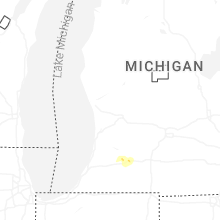
Michigan
| Local Time | Report Details |
|---|---|
| 3:57 PM EDT | 5 to 8 inch diameter branches dow in kalamazoo county MI, 47.5 miles S of Grand Rapids, MI |
| 3:57 PM EDT | Quarter sized hail reported near Portage, MI, 51.7 miles S of Grand Rapids, MI, report from mping: quarter (1.00 in.). |
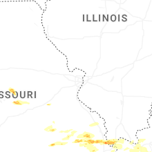
Illinois
| Local Time | Report Details |
|---|---|
| 3:49 PM CDT | Golf Ball sized hail reported near Mounds, IL, 22.8 miles ESE of Cape Girardeau, MO |
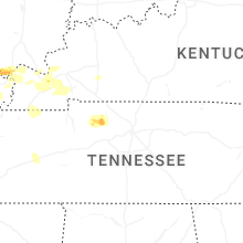
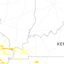
Kentucky
| Local Time | Report Details |
|---|---|
| 3:56 PM CDT | Quarter sized hail reported near Melber, KY, 49.4 miles ESE of Cape Girardeau, MO |
| 4:01 PM CDT | Powerlines dow in ballard county KY, 35.6 miles ESE of Cape Girardeau, MO |
| 4:11 PM CDT | Quarter sized hail reported near Wickliffe, KY, 34 miles SE of Cape Girardeau, MO |
| 4:26 PM CDT | Trees and powerlines dow in carlisle county KY, 45.2 miles SE of Cape Girardeau, MO |
| 4:31 PM CDT | Trees dow in graves county KY, 48.6 miles NNW of Mc Kenzie, TN |
| 4:50 PM CDT | Ping Pong Ball sized hail reported near Benton, KY, 57.1 miles N of Mc Kenzie, TN |
| 4:51 PM CDT | Powerlines dow in fulton county KY, 47.2 miles NW of Mc Kenzie, TN |
| 4:53 PM CDT | Quarter sized hail reported near Mayfield, KY, 47.9 miles N of Mc Kenzie, TN |
| 4:56 PM CDT | Quarter sized hail reported near Benton, KY, 57.6 miles N of Mc Kenzie, TN |
| 5:02 PM CDT | Trees and power lines down in mayfiel in graves county KY, 43.1 miles N of Mc Kenzie, TN |
| 5:10 PM CDT | Quarter sized hail reported near Benton, KY, 57.1 miles N of Mc Kenzie, TN |
| 5:13 PM CDT | Quarter sized hail reported near Benton, KY, 51 miles N of Mc Kenzie, TN |
| 5:17 PM CDT | Trees down... spotter estimated 60 mph win in marshall county KY, 51.8 miles NNE of Mc Kenzie, TN |
| 6:05 PM CDT | Roof blown off a garag in christian county KY, 62 miles NW of Nashville, TN |
| 6:08 PM CDT | Shingles blown off roof in hopkinsville. winds on the bypass observed at 50-55 mph. power poles knocked down in hopkinsvill in christian county KY, 61.7 miles NW of Nashville, TN |
| 6:20 PM CDT | Tree uprooted on silvey rd in hopkinsville k in christian county KY, 60.1 miles NW of Nashville, TN |
| 6:30 PM CDT | Kentucky mesonet measured 59 mph gus in todd county KY, 51.6 miles NNW of Nashville, TN |
| 6:45 PM CDT | Multiple trees and power lines down throughout southeast logan count in logan county KY, 43.7 miles NNW of Nashville, TN |
| 6:47 PM CDT | Downed trees reported off newtown roa in logan county KY, 48.8 miles N of Nashville, TN |
| 6:56 PM CDT | Roof ripped off a barn. time estimated from rada in logan county KY, 48.7 miles N of Nashville, TN |
| 7:13 PM CDT | Very large tree down over the 900 block of rapids road. the tree is blocking all lanes of traffi in simpson county KY, 39.9 miles NNE of Nashville, TN |
| 7:19 PM CDT | Tree down at the intersection of rapids road and grace road. tree is blocking all lanes of traffi in simpson county KY, 39.6 miles NNE of Nashville, TN |
| 7:25 PM CDT | Large tree down over the 3000 block of sportsman lake roa in simpson county KY, 45.7 miles NNE of Nashville, TN |
| 7:30 PM CDT | Tree down on power line on gayle wa in warren county KY, 59.4 miles NNE of Nashville, TN |
Tennessee
| Local Time | Report Details |
|---|---|
| 5:08 PM CDT | Several trees down in the south fulton are in obion county TN, 32.1 miles NW of Mc Kenzie, TN |
| 5:26 PM CDT | Report of a tree on a home on ralston road in marti in weakley county TN, 20.3 miles NW of Mc Kenzie, TN |
| 5:43 PM CDT | Tree down on henry midway roa in henry county TN, 9.2 miles NNE of Mc Kenzie, TN |
| 5:58 PM CDT | Tree down across log cabin road and buchanan road at cay lawrence roa in henry county TN, 24.7 miles NE of Mc Kenzie, TN |
| 6:01 PM CDT | Tree down over the intersection of west and east antioch roa in henry county TN, 28.1 miles NE of Mc Kenzie, TN |
| 6:02 PM CDT | Trees and power lines down on donelson parkway at the tn river bridge. reported by em in stewart county TN, 34.1 miles NE of Mc Kenzie, TN |
| 6:11 PM CDT | Report of a tree down on mansfield road at vale roa in henry county TN, 14.9 miles ENE of Mc Kenzie, TN |
| 6:12 PM CDT | Several trees and power lines down across benton count in benton county TN, 24.6 miles E of Mc Kenzie, TN |
| 6:16 PM CDT | Trees down on hwy 232 near leatherwood road reported by em in stewart county TN, 36.1 miles ENE of Mc Kenzie, TN |
| 6:34 PM CDT | Trees down... with one on power line and on fire. time estimated from rada in montgomery county TN, 44.9 miles NW of Nashville, TN |
| 6:45 PM CDT | Power outages in cumberland furnace. time estimated with rada in dickson county TN, 33.2 miles WNW of Nashville, TN |
| 6:45 PM CDT | Reports in adams and cedar hill of numerous trees down... as well as several brush fires in the same are in robertson county TN, 31.1 miles NNW of Nashville, TN |
| 7:00 PM CDT | Large limbs down on hwy 100. traffic still moving. time estimate in williamson county TN, 23.9 miles SW of Nashville, TN |
| 7:00 PM CDT | Trees down on hwy 47 and 48 in dickson county. multiple reports of power outages. relayed via nash severe w in dickson county TN, 31.4 miles W of Nashville, TN |
| 7:01 PM CDT | Reports of power outages in hickman county... with trees down in roads and roof damag in hickman county TN, 47.1 miles SW of Nashville, TN |
| 7:06 PM CDT | Roof damage to a convenience store from strong winds. time estimated from rada in dickson county TN, 32 miles W of Nashville, TN |
| 7:10 PM CDT | Trees across both lanes of crocker springs road. time estimated via rada in davidson county TN, 11.4 miles NNW of Nashville, TN |
| 7:19 PM CDT | Trees blocking sanders ferry road in hendersonvill in sumner county TN, 13.1 miles NE of Nashville, TN |
| 7:19 PM CDT | Huge tree down blocking shoulder and parts of the westbound lane on i-40. relayed by nash severe w in davidson county TN, 1.8 miles W of Nashville, TN |
| 7:25 PM CDT | Multiple reports of trees down in frankli in williamson county TN, 22.3 miles S of Nashville, TN |
| 7:25 PM CDT | Trees down on live power line... relayed via #tspotte in sumner county TN, 13.1 miles NE of Nashville, TN |
| 7:27 PM CDT | Several trees down across robertson county... including in springfield... orlinda... and greenbrier. power lines down as wel in robertson county TN, 24.9 miles NNW of Nashville, TN |
| 7:29 PM CDT | Power outages in hendersonvill in sumner county TN, 13.1 miles NE of Nashville, TN |
| 7:31 PM CDT | No working red lights and down trees on central pike in hermitage. time estimate in davidson county TN, 11.1 miles E of Nashville, TN |
| 7:36 PM CDT | Asos station peak gust kbna nashville intl airpor in davidson county TN, 6.4 miles ESE of Nashville, TN |
| 7:36 PM CDT | Tree down and on a car. time estimated from radar. relayed via faceboo in davidson county TN, 8 miles ESE of Nashville, TN |
| 7:37 PM CDT | Tree down in antioch on anderson road. time estimated from rada in davidson county TN, 11.6 miles SE of Nashville, TN |
| 7:45 PM CDT | Multiple reports of power outages in dickson county. relayed by amateur radi in dickson county TN, 34.4 miles W of Nashville, TN |
| 7:49 PM CDT | Tree down on the 7100 block of trousdale ferry pik in wilson county TN, 35.2 miles E of Nashville, TN |
| 7:49 PM CDT | Reports of utility poles down in between hartmann drive and hunters village drive. time estimate in wilson county TN, 27.6 miles E of Nashville, TN |
| 7:50 PM CDT | Fence down in rockvale due to the winds... relayed via broadcast medi in rutherford county TN, 31 miles SSE of Nashville, TN |
| 7:54 PM CDT | Report of large tree down on north side of armstrong valley road in south murfreesbor in rutherford county TN, 30.7 miles SE of Nashville, TN |
| 8:00 PM CDT | About 3000 people without power in wilson county according to em in wilson county TN, 27.5 miles E of Nashville, TN |
| 8:00 PM CDT | Tree down on a house in chapel hill. time estimated. relayed via #tspotte in marshall county TN, 37.3 miles S of Nashville, TN |
| 8:33 PM CDT | Wind damage to the roof of the library in manchester... tn. relayed via #tspotte in coffee county TN, 52.4 miles NW of Chattanooga, TN |
| 9:19 PM CDT | Reports of trees down on ashley drive in tullahoma. relayed via #tspotte in coffee county TN, 56.1 miles WNW of Chattanooga, TN |
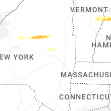
New York
| Local Time | Report Details |
|---|---|
| 6:34 PM EDT | Trees down along mill road near silver lak in st. lawrence county NY, 45.7 miles SE of Ogdensburg, NY |
| 6:54 PM EDT | Quarter sized hail reported near Forestport, NY, 54.3 miles ENE of Syracuse, NY, hail size estimated from video posted to broadcast media social media page. |
| 7:16 PM EDT | Tree downe in oswego county NY, 23.8 miles NW of Syracuse, NY |
| 9:11 PM EDT | Quarter sized hail reported near Mayfield, NY, 25.6 miles NW of Schenectady, NY, quarter size hail was reported in the village of mayfield. |
Texas
| Local Time | Report Details |
|---|---|
| 6:52 PM CDT | Hen Egg sized hail reported near Sanderson, TX, 77.7 miles E of Alpine, TX, phone call with fire rescue confirmed 2 inch hail from a cell in sanderson. |
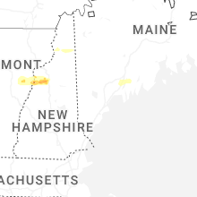
New Hampshire
| Local Time | Report Details |
|---|---|
| 8:05 PM EDT | Quarter sized hail reported near Groveton, NH, 84.5 miles E of Burlington, VT, quarter-sized hail in groveton near intersection of main street and us highway 3. |
| 8:20 PM EDT | Ping Pong Ball sized hail reported near Milan, NH, 82.7 miles NW of Portland, ME, off-duty ems observed hail measured 1.5 inches in dummer. hail began at 8:20. |
| 8:20 PM EDT | Off-duty ems (post-storm). observed downed trees along rte 16 (berlin rd) near the pontook reservoi in coos county NH, 83.8 miles NW of Portland, ME |
| 9:48 PM EDT | Ping Pong Ball sized hail reported near North Haverhill, NH, 64.5 miles ESE of Burlington, VT, hail up to 1.5 inches in north haverhill on route 10. spotter id: hl590. |
| 9:50 PM EDT | Half Dollar sized hail reported near North Haverhill, NH, 67 miles ESE of Burlington, VT, delayed report. social media photos of hail up to 1.25 inches in diameter in center haverhill near intersection of route 116 and french pond rd. wind damage reports str |
| 9:53 PM EDT | Delayed report. multiple trees down on sawyer hill road between goose lane and nh hwy 112. largest tree diameter between 12 and 18 inche in grafton county NH, 65.6 miles ESE of Burlington, VT |
| 9:58 PM EDT | Delayed report. trees downed on power lines in lisbon. power outages also reporte in grafton county NH, 67.1 miles ESE of Burlington, VT |
| 10:05 PM EDT | Delayed report. trees and several large branches partially blocking sections of lost river road... stretching from nh hwy 116 east to the wildwood campgroun in grafton county NH, 78 miles ESE of Burlington, VT |
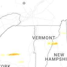
Vermont
| Local Time | Report Details |
|---|---|
| 9:30 PM EDT | Quarter sized hail reported near West Topsham, VT, 51.1 miles ESE of Burlington, VT |
| 9:35 PM EDT | Power pole down on fairview s in washington county VT, 40.5 miles ESE of Burlington, VT |
| 9:40 PM EDT | Corrects previous tstm wnd dmg report time from 3 ene ainsworth state park. tree down on power lines near intersection of chelsea rd and baptist s in orange county VT, 43.9 miles SE of Burlington, VT |
| 10:53 PM EDT | Tree down on power lines near intersection of chelsea rd and baptist s in orange county VT, 43.9 miles SE of Burlington, VT |
Connect with Interactive Hail Maps