

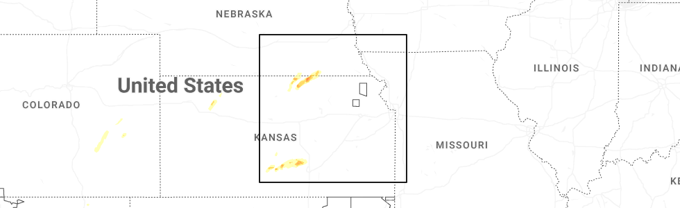
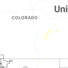
Hail Map for Saturday, April 11, 2026
Number of Impacted Households on 4/11/2026
0
Impacted by 1" or Larger Hail
0
Impacted by 1.75" or Larger Hail
0
Impacted by 2.5" or Larger Hail
Square Miles of Populated Area Impacted on 4/11/2026
0
Impacted by 1" or Larger Hail
0
Impacted by 1.75" or Larger Hail
0
Impacted by 2.5" or Larger Hail
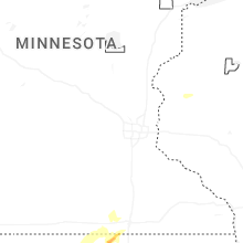
Cities Most Affected by Hail Storms of 4/11/2026
| Hail Size | Demographics of Zip Codes Affected | ||||||
|---|---|---|---|---|---|---|---|
| City | Count | Average | Largest | Pop Density | House Value | Income | Age |
| Arlington, KS | 1 | 1.75 | 1.75 | 4 | $38k | $33.2k | 41.5 |
Hail and Wind Damage Spotted on 4/11/2026
Filter by Report Type:Hail ReportsWind Reports
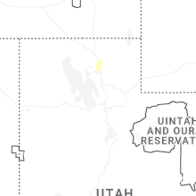
States Impacted
Utah, Idaho, Colorado, Wyoming, Texas, Kansas, Montana, New Mexico, Oregon, Nebraska, California, Missouri, Oklahoma, IowaUtah
| Local Time | Report Details |
|---|---|
| 11:56 AM MDT | Mesonet station fw8325 garden cit in rich county UT, 85.5 miles NNE of Salt Lake City, UT |
| 12:30 PM MDT | Storm damage reported in tooele county UT, 34 miles WSW of Salt Lake City, UT |
| 1:45 PM MDT | Mesonet station hatut hat islan in box elder county UT, 42.5 miles WNW of Salt Lake City, UT |
| 1:54 PM MDT | Half Dollar sized hail reported near Logan, UT, 66.3 miles N of Salt Lake City, UT, report from mping: half dollar (1.25 in.). |
Idaho
| Local Time | Report Details |
|---|---|
| 12:40 PM MDT | Mesonet station pc506 sheep creek hill in bear lake county ID, 91 miles SSE of Idaho Falls, ID |
| 1:00 PM MDT | Mesonet station grei 1 nw nite in caribou county ID, 68.8 miles SSE of Idaho Falls, ID |
| 3:30 PM MDT | Mesonet station rrwbt relay ridge win in teton county ID, 38.3 miles ENE of Idaho Falls, ID |
Colorado
| Local Time | Report Details |
|---|---|
| 12:42 PM MDT | Storm damage reported in garfield county CO, 55.3 miles NE of Grand Junction, CO |
| 4:15 PM MDT | Local resident reported an outflow wind blew the roof off of his rv barn. an approximately 40ft x 20ft sectio in mesa county CO, 14.6 miles NW of Grand Junction, CO |
| 4:35 PM MDT | Personal weather station measured a 61 mph wind gus in kiowa county CO, 78.4 miles ENE of Pueblo, CO |
| 5:10 PM MDT | Chaser recorded 70 mph winds and 2 mile visibility in blowing dust. wind speed measure via handheld anemomete in cheyenne county CO, 101.8 miles ENE of Pueblo, CO |
| 5:14 PM MDT | Up729 (up) site reported a 63 mph gus in cheyenne county CO, 93.8 miles S of Yuma, CO |
| 5:39 PM MDT | Mesonet station co068 040w460 u40-firstvie in cheyenne county CO, 89.7 miles WSW of Colby, KS |
| 5:46 PM MDT | Asos station keeo meeker airpor in rio blanco county CO, 36.5 miles SSW of Craig, CO |
| 5:54 PM MDT | Kitr reported a 72 mph gus in kit carson county CO, 65 miles SSE of Yuma, CO |
| 6:11 PM MDT | Sevenfarms (awn) site reported a 60 mph gus in kit carson county CO, 49.2 miles S of Yuma, CO |
| 6:11 PM MDT | Kcostrat21 (wu) site reported a 60 mph gus in kit carson county CO, 50.9 miles SSE of Yuma, CO |
| 6:37 PM MDT | Public report of blowing dust with visibility to 1/2 mile with 60 mph wind gus in yuma county CO, 36.9 miles SE of Yuma, CO |
| 6:38 PM MDT | Kcoidali9 (wu) site reported a 60 mph gus in yuma county CO, 41.1 miles SSE of Yuma, CO |
| 6:40 PM MDT | Asos station kitr burlington co airpor in kit carson county CO, 65.7 miles SSE of Yuma, CO |
| 6:57 PM MDT | Mesonet station dhoc2 dead horse... buford 14en in rio blanco county CO, 31.4 miles SSE of Craig, CO |
| 7:00 PM MDT | Corrects previous tstm wnd gst report from hale. tt563 site reported a 68 mph gus in yuma county CO, 46.5 miles SE of Yuma, CO |
| 7:45 PM MDT | Tt563 site reported a 68 mph gus in yuma county CO, 46.5 miles SE of Yuma, CO |
Wyoming
| Local Time | Report Details |
|---|---|
| 1:00 PM MDT | Mesonet station ew1855 etna 1 (cwop in lincoln county WY, 58.3 miles ESE of Idaho Falls, ID |
| 1:50 PM MDT | Mesonet station pc452 cottonwood merna (pc in sublette county WY, 98 miles W of Riverton, WY |
| 4:02 PM MDT | Corrects previous tstm wnd gst report from 3 w evanston. evanston-uinta county airport reported a gust of 64 mp in uinta county WY, 57 miles NE of Salt Lake City, UT |
| 4:02 PM MDT | Corrects previous tstm wnd gst report from 3 w evanston. evanston-uinta county airport reported a gust of 64 mp in uinta county WY, 57 miles NE of Salt Lake City, UT |
| 4:02 PM MDT | Medicine butte cwop reported a gust of 69 mp in uinta county WY, 65.3 miles NE of Salt Lake City, UT |
| 4:10 PM MDT | First divide wydot sensor reported a 66 mph gus in uinta county WY, 67.3 miles ENE of Salt Lake City, UT |
| 4:16 PM MDT | I80 coal road wydot sensor reported a 58 mph wind gus in uinta county WY, 72.9 miles ENE of Salt Lake City, UT |
| 4:20 PM MDT | Mesonet station pc577 midwest (pc in natrona county WY, 41.4 miles N of Casper, WY |
| 4:22 PM MDT | Mesonet station krec wy28 red canyon (dot in fremont county WY, 30.3 miles SSW of Riverton, WY |
| 4:30 PM MDT | Mesonet station pc460 buffalo south (pc in johnson county WY, 59.8 miles W of Gillette, WY |
| 4:38 PM MDT | Asos station kbyg buffalo airport (asos in johnson county WY, 60.5 miles W of Gillette, WY |
| 4:40 PM MDT | Mesonet station pc462 irma lake (pc in park county WY, 102.6 miles NNW of Riverton, WY |
| 4:57 PM MDT | 70 mph wind gust recorded at verne1 (up199) mesonet senso in uinta county WY, 46 miles W of Rock Springs, WY |
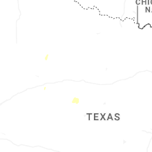
Texas
| Local Time | Report Details |
|---|---|
| 3:46 PM CDT | Mesonet station 123 1nw castolon... bbnp big bend np/brewste in brewster county TX, 83.6 miles S of Alpine, TX |
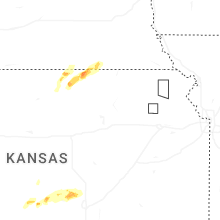
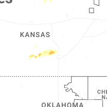
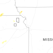
Kansas
| Local Time | Report Details |
|---|---|
| 4:04 PM CDT | Quarter sized hail reported near Republic, KS, 75.6 miles SSE of Grand Island, NE |
| 4:30 PM CDT | Corrects previous non-tstm wnd dmg report from 2 wsw oakley. delayed report. 1/2 mile west of oakley on county road a... time estimated. bin for ground cane storage was in logan county KS, 20.8 miles SSE of Colby, KS |
| 4:33 PM CDT | Golf Ball sized hail reported near Arlington, KS, 47.2 miles W of Wichita, KS, mping report. |
| 4:50 PM CDT | Quarter sized hail reported near Belleville, KS, 70 miles WNW of Manhattan, KS |
| 4:51 PM CDT | Half Dollar sized hail reported near Belleville, KS, 69.9 miles NW of Manhattan, KS, report from mping: half dollar (1.25 in.). |
| 4:55 PM CDT | Semi truck and trailer blown ove in reno county KS, 34.3 miles WNW of Wichita, KS |
| 5:05 PM CDT | Semi rolled over near k14 and parallel road. another separate vehicle damaged nearb in reno county KS, 34.3 miles WNW of Wichita, KS |
| 5:21 PM CDT | Power lines knocked down near intersection of east parallel rd and victory r in reno county KS, 25.2 miles WNW of Wichita, KS |
| 5:26 PM CDT | Ping Pong Ball sized hail reported near Mount Hope, KS, 22.2 miles NW of Wichita, KS |
| 5:26 PM CDT | Delayed report... four power poles snapped and lines down across 295th w at 93rd st. nort in sedgwick county KS, 22 miles WNW of Wichita, KS |
| 5:30 PM CDT | Storm damage reported in sedgwick county KS, 21.8 miles NW of Wichita, KS |
| 5:31 PM CDT | Storm damage reported in sedgwick county KS, 22.2 miles NW of Wichita, KS |
| 6:20 PM CDT | Nickel hail was also reporte in sedgwick county KS, 17.3 miles NW of Wichita, KS |
| 6:30 PM CDT | Storm damage reported in sedgwick county KS, 12.6 miles N of Wichita, KS |
| 7:09 PM MDT | Kkskanor6 (wu) site reported a 68 mph gus in sherman county KS, 48.1 miles W of Colby, KS |
| 8:18 PM CDT | Kkssaint20 (wu) site reported a 64 mph gus in cheyenne county KS, 47.4 miles WNW of Colby, KS |
| 8:21 PM CDT | Ksyf awos reported a 76 mph gus in cheyenne county KS, 47.4 miles WNW of Colby, KS |
| 8:39 PM CDT | Kkssaint20 wxundergroun in cheyenne county KS, 47.4 miles WNW of Colby, KS |
Montana
| Local Time | Report Details |
|---|---|
| 3:45 PM MDT | 58 mph convective wind gus in fergus county MT, 55.7 miles E of Great Falls, MT |
| 6:15 PM MDT | Winnett mt dot surface statio in petroleum county MT, 85 miles N of Billings, MT |
| 6:30 PM MDT | Malta south mt dot statio in phillips county MT, 75 miles ESE of Havre, MT |
| 7:40 PM MDT | Jordan airport statio in garfield county MT, 61.5 miles SSW of Glasgow, MT |
| 8:42 PM MDT | Glasgow aso in valley county MT, 1.3 miles NE of Glasgow, MT |
New Mexico
| Local Time | Report Details |
|---|---|
| 4:14 PM MDT | Asos station kfmn farmington airport from a virga (evaporating) showe in san juan county NM, 2 miles NW of Farmington, NM |
| 5:20 PM MDT | Mesonet station swcn5 sw clayto in union county NM, 78.6 miles NNE of Tucumcari, NM |
| 5:36 PM MDT | Corrects previous non-tstm wnd gst report from 1 e clayton. asos station kcao clayton muni airpar in union county NM, 93.4 miles NNE of Tucumcari, NM |
Oregon
| Local Time | Report Details |
|---|---|
| 5:18 PM PDT | Multiple photos of what appears to be a gustnado near the intersection of highway 20 and old bend redmond highwa in deschutes county OR, 26.5 miles WSW of Bend, OR |
Nebraska
| Local Time | Report Details |
|---|---|
| 8:21 PM CDT | Awos station kfnb falls city airpor in richardson county NE, 80.8 miles NE of Manhattan, KS |
California
| Local Time | Report Details |
|---|---|
| 6:30 PM PDT | Trained spotter reported a small downed tree with thunderstorms in elk grove. nearby wind gusts measured 42 mp in sacramento county CA, 21.5 miles SSW of Citrus Heights, CA |
| 7:13 PM PDT | California highway patrol reported a downed tree blocking all lanes. wind gusts in the area measured between 30 and 40 mp in sacramento county CA, 4 miles SE of Citrus Heights, CA |
| 7:14 PM PDT | California highway patrol reported a downed tree. wind gusts in the area measured between 30 to 40 mp in sacramento county CA, 16.6 miles SSW of Citrus Heights, CA |
Missouri
| Local Time | Report Details |
|---|---|
| 9:06 PM CDT | Report from personal weather station. time matches with when the core of the storm passed over the station on rada in atchison county MO, 72.6 miles SSE of Omaha, NE |
Oklahoma
| Local Time | Report Details |
|---|---|
| 9:07 PM CDT | Wind gust of 59 mph measured at the asos station kguy guymon (asos in texas county OK, 95.4 miles SSW of Garden City, KS |
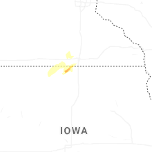
Iowa
| Local Time | Report Details |
|---|---|
| 2:55 AM CDT | Half Dollar sized hail reported near Thompson, IA, 32.9 miles WNW of Mason City, IA, picture of hail north of thompson. relayed by kiow radio. |
Connect with Interactive Hail Maps