

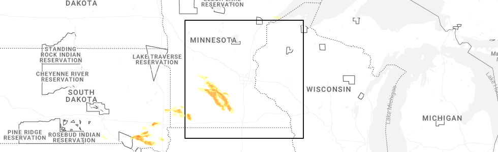
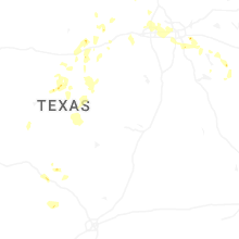
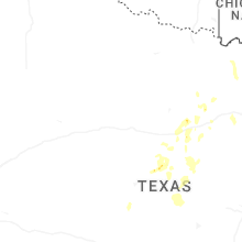
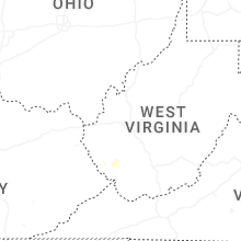
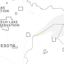
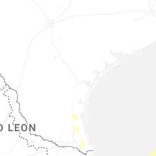
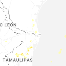
Hail Map for Sunday, May 24, 2026
Number of Impacted Households on 5/24/2026
0
Impacted by 1" or Larger Hail
0
Impacted by 1.75" or Larger Hail
0
Impacted by 2.5" or Larger Hail
Square Miles of Populated Area Impacted on 5/24/2026
0
Impacted by 1" or Larger Hail
0
Impacted by 1.75" or Larger Hail
0
Impacted by 2.5" or Larger Hail
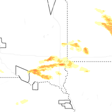

Cities Most Affected by Hail Storms of 5/24/2026
| Hail Size | Demographics of Zip Codes Affected | ||||||
|---|---|---|---|---|---|---|---|
| City | Count | Average | Largest | Pop Density | House Value | Income | Age |
| Tripp, SD | 2 | 1.88 | 2.00 | 3 | $20k | $26.0k | 52.6 |
| Freeman, SD | 1 | 2.00 | 2.00 | 5 | $52k | $31.0k | 47.7 |
| Scotland, SD | 1 | 1.75 | 1.75 | 5 | $35k | $30.4k | 44.9 |
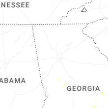
Hail and Wind Damage Spotted on 5/24/2026
Filter by Report Type:Hail ReportsWind Reports
States Impacted
Georgia, Wyoming, Texas, Kentucky, Tennessee, New Mexico, West Virginia, South Dakota, Minnesota, Arizona, IowaGeorgia
| Local Time | Report Details |
|---|---|
| 3:30 PM EDT | At least 1 tree down near the intersection of green view road sw and horseleg creek rd sw blocking the roadwa in floyd county GA, 55.9 miles S of Chattanooga, TN |
| 3:30 PM EDT | There were 3 small trees blown over hitting a vehicle. no injurie in floyd county GA, 53.8 miles S of Chattanooga, TN |
| 3:40 PM EDT | At least 1 tree down along big texas valley road nw partially blocking the roa in floyd county GA, 46.6 miles S of Chattanooga, TN |
| 3:45 PM EDT | At least 1 tree down along minshew road ne partially blocking the roadwa in floyd county GA, 49.8 miles SSE of Chattanooga, TN |
| 4:03 PM EDT | There were a couple of reports of trees down in baker count in baker county GA, 57.7 miles NNW of Tallahassee, FL |
| 4:20 PM EDT | Tree down on antioch road sw of adel. time estimated by rada in cook county GA, 45.7 miles SW of Douglas, GA |
| 4:59 PM EDT | Several trees reported down south of shellma in randolph county GA, 78.4 miles SE of Auburn, AL |
| 5:02 PM EDT | Several trees down on graves highway west of dawso in terrell county GA, 81.1 miles SE of Auburn, AL |
| 5:41 PM EDT | Tree down on james driv in worth county GA, 65.6 miles W of Douglas, GA |
| 5:43 PM EDT | Trees down along waterloo rebecca highwa in irwin county GA, 38.7 miles WNW of Douglas, GA |
| 5:54 PM EDT | Tree down along highway 31 south near mile marker in turner county GA, 47.7 miles WNW of Douglas, GA |
| 6:10 PM EDT | Tree down along highway 112 near rebecc in turner county GA, 43 miles WNW of Douglas, GA |
| 6:20 PM EDT | Tree down on power lines on tommy harrell rd. time estimated via rada in jeff davis county GA, 31.4 miles NE of Douglas, GA |
| 6:20 PM EDT | A tree downed blocking the road at the intersection of cemetery road and sirmons roa in crisp county GA, 56.8 miles NW of Douglas, GA |
| 6:20 PM EDT | A tree downed blocking the road in hatley east of hwy 9 in crisp county GA, 57 miles WNW of Douglas, GA |
| 6:30 PM EDT | A tree downed blocking the road at the intersection of tremont road and brown roa in crisp county GA, 57.1 miles NW of Douglas, GA |
Wyoming
| Local Time | Report Details |
|---|---|
| 1:42 PM MDT | Mesonet station wy50 i-25 f street (dot in natrona county WY, 1.5 miles NNW of Casper, WY |
| 2:00 PM MDT | Mesonet station mcobt mount coffin (btac in lincoln county WY, 92.2 miles SE of Idaho Falls, ID |
| 4:54 PM MDT | Asos station krks rock springs airport (asos in sweetwater county WY, 8 miles E of Rock Springs, WY |
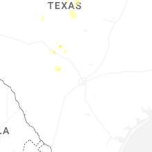
Texas
| Local Time | Report Details |
|---|---|
| 3:15 PM CDT | Quarter sized hail reported near Justin, TX, 40 miles NW of Dallas, TX |
| 3:55 PM CDT | Photos of fence blown down and several large trees with large branches snapped. tree damage consistent with severe microburst winds over 60 mp in tarrant county TX, 22.6 miles WNW of Dallas, TX |
| 5:00 PM CDT | Quarter sized hail reported near Athens, TX, 70 miles SE of Dallas, TX, social media video. |
| 5:15 PM CDT | Several large tree branches snapped. time estimate in dallas county TX, 8.5 miles W of Dallas, TX |
Kentucky
| Local Time | Report Details |
|---|---|
| 4:42 PM EDT | Corrects source of previous tstm wnd dmg report from 1 nne bosco. resends previous tstm wnd dmg report from 1 nne bosco due to iris error message. floyd county 911 repo in floyd county KY, 63.5 miles E of Irvine, KY |
| 5:08 PM EDT | Corrects source of previous tstm wnd dmg report from 2 nw heenan. pike county 911 reports downed trees at 8619 big creek/branch road in the pikeville fire district. tim in pike county KY, 66.2 miles SW of Charleston, WV |
| 5:13 PM EDT | Floyd county 911 reports downed trees on ky-3379 near branham creek. time estimated by rada in floyd county KY, 64 miles NNW of Bristol, TN |
| 5:27 PM EDT | Pike county 911 reports downed trees at 3133 turkey creek road in belfry. time estimated by rada in pike county KY, 61.2 miles SW of Charleston, WV |
| 5:44 PM EDT | Social media report of multiple trees down near mcveigh. time and exact location estimated by rada in pike county KY, 64.7 miles N of Bristol, TN |
Tennessee
| Local Time | Report Details |
|---|---|
| 5:09 PM EDT | Powerlines down. time approximated by rada in hamilton county TN, 6.5 miles N of Chattanooga, TN |
| 5:27 PM EDT | Several trees down across the count in hamilton county TN, 5.2 miles NNW of Chattanooga, TN |
New Mexico
| Local Time | Report Details |
|---|---|
| 3:25 PM MDT | Asos station krtn raton crews airpor in colfax county NM, 63.6 miles ENE of Taos, NM |
| 8:13 PM MDT | The tatum mesonet site reported a gust of 61 mp in lea county NM, 68.7 miles E of Roswell, NM |
West Virginia
| Local Time | Report Details |
|---|---|
| 5:36 PM EDT | Large tree dow in mingo county WV, 57.9 miles SW of Charleston, WV |
| 5:38 PM EDT | 3 large trees uproote in mingo county WV, 57 miles SW of Charleston, WV |
| 5:38 PM EDT | Tree down along buffalo creek roa in mingo county WV, 55.6 miles SW of Charleston, WV |
| 5:43 PM EDT | Tree down blocking both lanes of traffic on elk creek roa in mingo county WV, 52 miles SW of Charleston, WV |
| 5:43 PM EDT | Tree down on a traile in mingo county WV, 52.5 miles SW of Charleston, WV |
| 5:47 PM EDT | Large tree dow in mingo county WV, 57 miles SW of Charleston, WV |
| 6:04 PM EDT | Power lines down. verified through social media phot in logan county WV, 39.4 miles SSW of Charleston, WV |
| 6:06 PM EDT | Tree damage resulting in over 950 customers without powe in logan county WV, 40.5 miles SSW of Charleston, WV |
| 8:48 PM EDT | The greenbrier county 911 center reported three trees blown down by thunderstorm winds along the 1900 block of miller road. the time of occurrence was estimated by rada in greenbrier county WV, 58.8 miles NW of Roanoke, VA |
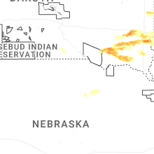
South Dakota
| Local Time | Report Details |
|---|---|
| 5:11 PM CDT | Quarter sized hail reported near Tripp, SD, 57.9 miles NNE of Oneill, NE |
| 5:26 PM CDT | Half Dollar sized hail reported near Tripp, SD, 63.5 miles NNE of Oneill, NE, sheriff reported half dollar size hail. |
| 5:40 PM CDT | Golf Ball sized hail reported near Tripp, SD, 62.5 miles WSW of Sioux Falls, SD |
| 5:55 PM CDT | Hen Egg sized hail reported near Tripp, SD, 59.7 miles WSW of Sioux Falls, SD |
| 5:58 PM CDT | Golf Ball sized hail reported near Scotland, SD, 57.7 miles WSW of Sioux Falls, SD |
| 6:50 PM CDT | Half Dollar sized hail reported near Scotland, SD, 56.8 miles WSW of Sioux Falls, SD |
| 6:51 PM CDT | Ping Pong Ball sized hail reported near Scotland, SD, 59.3 miles WSW of Sioux Falls, SD, corrects previous hail report from 5 s scotland. off duty nssl employee reported ping pong ball size hail. |
| 7:06 PM CDT | Ping Pong Ball sized hail reported near Scotland, SD, 59.3 miles WSW of Sioux Falls, SD, off duty nssl employee reported ping pong ball size hail. |
| 7:47 PM CDT | Quarter sized hail reported near Utica, SD, 52.6 miles SW of Sioux Falls, SD |
| 8:01 PM CDT | Ping Pong Ball sized hail reported near Menno, SD, 45.2 miles WSW of Sioux Falls, SD |
| 8:10 PM CDT | Ping Pong Ball sized hail reported near Utica, SD, 48 miles SW of Sioux Falls, SD |
| 9:05 PM CDT | Ping Pong Ball sized hail reported near Freeman, SD, 37.6 miles WSW of Sioux Falls, SD, freeman fire rescue reported pea to ping-pong ball sized hail in freeman. time was estimated via radar. |
| 9:05 PM CDT | Hen Egg sized hail reported near Freeman, SD, 37.6 miles WSW of Sioux Falls, SD, received a photo of 2 inch hail in freeman via social media. timing was estimated from radar. |
| 10:22 PM CDT | Quarter sized hail reported near Harrisburg, SD, 8.8 miles S of Sioux Falls, SD, received a public report of quarter sized hail near harrisburg. time estimated via radar. |
| 11:30 PM CDT | Quarter sized hail reported near Sioux Falls, SD, 2.3 miles SW of Sioux Falls, SD, got an mping report of quarter sized hail in sioux falls. time estimated via radar. |
| 11:40 PM CDT | Quarter sized hail reported near Brandon, SD, 6.4 miles ENE of Sioux Falls, SD, mping report of quarter (1.00 in.) sized hail just west of brandon. time estimated via radar. |
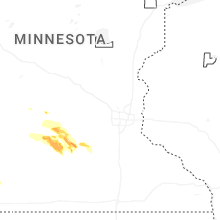
Minnesota
| Local Time | Report Details |
|---|---|
| 5:20 PM CDT | Quarter sized hail reported near Pipestone, MN, 37.8 miles NNE of Sioux Falls, SD, most of the hail was dime to nickel sized. a few quarters were mixed in. |
| 6:05 PM CDT | Half Dollar sized hail reported near Woodstock, MN, 45 miles NE of Sioux Falls, SD, a trained spotter reported half dollar sized hail in woodstock... mn. time estimated via radar. |
| 6:46 PM CDT | Lots of blowing dust ahead of severe warned thunderstorms. spotter estimated 50-60 mph wind in nicollet county MN, 65.9 miles SW of Minneapolis, MN |
| 6:51 PM CDT | Quarter sized hail reported near New Ulm, MN, 74.2 miles SE of Montevideo, MN |
| 6:58 PM CDT | Quarter sized hail reported near New Ulm, MN, 74.9 miles SW of Minneapolis, MN |
| 7:03 PM CDT | Quarter sized hail reported near New Ulm, MN, 75 miles SE of Montevideo, MN |
| 7:18 PM CDT | Half Dollar sized hail reported near Chandler, MN, 43.4 miles ENE of Sioux Falls, SD |
Arizona
| Local Time | Report Details |
|---|---|
| 5:15 PM MST | Asos station kdma davis monthan af in pima county AZ, 6.9 miles ESE of Tucson, AZ |
Iowa
| Local Time | Report Details |
|---|---|
| 1:37 AM CDT | Half Dollar sized hail reported near Sanborn, IA, 44.1 miles NNW of Storm Lake, IA, mping report of half dollar (1.25 in.) sized hail near sanborn... ia. time estimated via radar. |
Connect with Interactive Hail Maps