

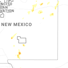
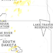
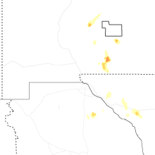
Hail Map for Tuesday, June 2, 2026

Number of Impacted Households on 6/2/2026
0
Impacted by 1" or Larger Hail
0
Impacted by 1.75" or Larger Hail
0
Impacted by 2.5" or Larger Hail
Square Miles of Populated Area Impacted on 6/2/2026
0
Impacted by 1" or Larger Hail
0
Impacted by 1.75" or Larger Hail
0
Impacted by 2.5" or Larger Hail

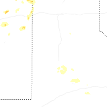
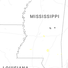
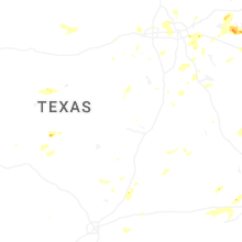
Cities Most Affected by Hail Storms of 6/2/2026
| Hail Size | Demographics of Zip Codes Affected | ||||||
|---|---|---|---|---|---|---|---|
| City | Count | Average | Largest | Pop Density | House Value | Income | Age |
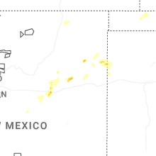
| Mayhill, NM | 1 | 3.50 | 3.50 | 2 | $93k | $32.3k | 56.0 |
| Mission, SD | 2 | 1.75 | 1.75 | 1 | $37k | $22.7k | 24.5 |
| Philip, SD | 2 | 1.75 | 1.75 | 0 | $52k | $31.7k | 49.7 |
| Baker, MT | 1 | 3.00 | 3.00 | 0 | $49k | $30.7k | 42.1 |
| Frisco, TX | 1 | 2.00 | 2.00 | 1046 | $183k | $69.6k | 34.1 |
| Rocklake, ND | 1 | 1.75 | 1.75 | 0 | $25k | $27.2k | 48.5 |
| Belcourt, ND | 1 | 1.75 | 1.75 | 7 | $64k | $23.3k | 26.7 |
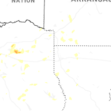
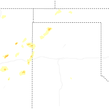
Hail and Wind Damage Spotted on 6/2/2026
Filter by Report Type:Hail ReportsWind Reports
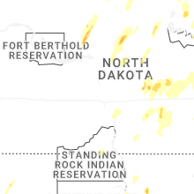
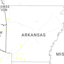
States Impacted
North Dakota, Arkansas, Texas, Louisiana, New Mexico, Wyoming, Florida, South Dakota, West Virginia, Montana, OklahomaNorth Dakota
| Local Time | Report Details |
|---|---|
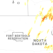
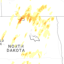
| 12:30 PM CDT | Quarter sized hail reported near Osnabrock, ND, 51.6 miles NE of Devils Lake, ND |
| 1:56 PM CDT | Golf Ball sized hail reported near Belcourt, ND, 69.4 miles NW of Devils Lake, ND, golf ball sized hail estimated. public report relayed by broadcast media. |
| 3:05 PM CDT | Half Dollar sized hail reported near Rocklake, ND, 50 miles NNW of Devils Lake, ND, hail slightly bigger than quarter size fell for 2 to 3 minutes. |
| 3:10 PM CDT | Golf Ball sized hail reported near Rocklake, ND, 65.4 miles NNW of Devils Lake, ND |
| 4:45 PM CDT | Quarter sized hail reported near Calvin, ND, 51.1 miles N of Devils Lake, ND |
| 5:01 PM CDT | Quarter sized hail reported near Crary, ND, 14.9 miles ESE of Devils Lake, ND |
| 5:24 PM CDT | Quarter sized hail reported near Brocket, ND, 20 miles E of Devils Lake, ND |
| 5:50 PM CDT | Quarter sized hail reported near Robinson, ND, 52.6 miles ENE of Bismarck, ND, photo relayed from broadcast media of up to quarter sized hail lasting about 10 minutes in robinson. |
| 6:06 PM CDT | Reported by ndaw in walsh county ND, 44.7 miles NE of Devils Lake, ND |
| 6:37 PM CDT | Ndawn station 7 ne of zeelan in mcintosh county ND, 69.5 miles WNW of Aberdeen, SD |
| 6:56 PM CDT | Quarter sized hail reported near Pettibone, ND, 63.4 miles ENE of Bismarck, ND, quarter sized hail reported. nearby report of smaller hail but a lot of hail. |
| 7:09 PM CDT | Measured wind gust from private weather statio in kidder county ND, 64.7 miles ENE of Bismarck, ND |
| 8:13 PM CDT | Measured wind gust from private weather statio in stutsman county ND, 65.4 miles S of Devils Lake, ND |
| 8:30 PM CDT | 10 meter measured wind gust at 5 w courtenay ndawn statio in stutsman county ND, 62.2 miles S of Devils Lake, ND |
| 8:30 PM CDT | Measured wind gust at private weather statio in stutsman county ND, 55.5 miles S of Devils Lake, ND |
| 9:35 PM CDT | Measured wind gust at the awos station ks32 cooperstown ap n in griggs county ND, 59.4 miles SE of Devils Lake, ND |
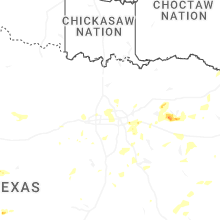
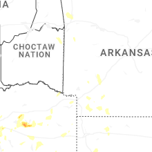
Arkansas
| Local Time | Report Details |
|---|---|
| 1:11 PM CDT | Tree down on highway 371 and hempstead 310 near crossroad in hempstead county AR, 16.2 miles SSE of Nashville, AR |
| 1:45 PM CDT | A tree fell and snapped two power poles near the post office. this resulted in power outages in the downtown magnolia square and surrounding area in columbia county AR, 58.7 miles SE of Nashville, AR |
| 1:45 PM CDT | A few trees were knocked down onto powerline in clark county AR, 30.5 miles E of Nashville, AR |
| 2:03 PM CDT | Tree down on highway 371 between taylor and springhil in columbia county AR, 40.5 miles NNE of Shreveport, LA |
| 2:18 PM CDT | Large tree down on county road 22 between stamps and lewisvill in lafayette county AR, 45.1 miles SSE of Nashville, AR |
| 2:35 PM CDT | A downed tree and power line on us highway 371 just north of columbia road 27 sout in columbia county AR, 52.2 miles NNE of Shreveport, LA |
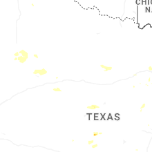
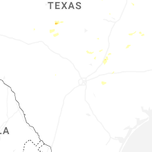
Texas
| Local Time | Report Details |
|---|---|
| 1:29 PM CDT | Local media provided picture of boat dock covering destroyed on lake tyler eas in smith county TX, 67.7 miles NNW of Lufkin, TX |
| 1:45 PM CDT | Corrects previous tstm wnd dmg report from whitehouse. tree on hous in smith county TX, 67.9 miles NNW of Lufkin, TX |
| 1:48 PM CDT | Large tree blown down at corner of baylor drive and karen drive in tyle in smith county TX, 72.5 miles NNW of Lufkin, TX |
| 2:00 PM CDT | Trees down across harrison county east of marshal in harrison county TX, 31.8 miles W of Shreveport, LA |
| 2:30 PM CDT | Trees down in hallsvill in harrison county TX, 48 miles W of Shreveport, LA |
| 2:35 PM CDT | Trees down around lindal in smith county TX, 80.6 miles ESE of Dallas, TX |
| 2:45 PM CDT | Tree on hous in smith county TX, 67.9 miles NNW of Lufkin, TX |
| 3:30 PM CDT | Facebook report and photos of several trees down in tennessee colony with one tree completely blocking fm 321. one home had minor roof damag in anderson county TX, 74.5 miles WNW of Lufkin, TX |
| 3:40 PM CDT | Quarter sized hail reported near Lavon, TX, 27 miles NE of Dallas, TX |
| 3:45 PM CDT | Trees down across harrison count in harrison county TX, 37.1 miles W of Shreveport, LA |
| 3:50 PM CDT | Facebook report of large tree branches down and nickel size hail on beaver creek rd. time estimate in collin county TX, 22.5 miles NE of Dallas, TX |
| 4:12 PM CDT | Spotter report of a few large tree branches down in northeast part of combin in kaufman county TX, 21.1 miles SE of Dallas, TX |
| 4:15 PM CDT | 911 dispatch reported a few trees down around the community of martinsville. time estimated by rada in nacogdoches county TX, 27 miles NE of Lufkin, TX |
| 4:17 PM CDT | Quarter sized hail reported near Houston, TX, 17.3 miles NW of Houston, TX, broadcast media passed along a report from a caller... mentioning hail was occurring along cypress north houston road. hail was estimated at nickel to quarter size. |
| 4:21 PM CDT | Quarter sized hail reported near Houston, TX, 18.5 miles WNW of Houston, TX, report from mping: quarter (1.00 in.). |
| 4:23 PM CDT | Quarter sized hail reported near Houston, TX, 19.7 miles WNW of Houston, TX, report from mping: quarter (1.00 in.). |
| 4:27 PM CDT | Quarter sized hail reported near Forney, TX, 23.6 miles ESE of Dallas, TX, report from mping: quarter (1.00 in.). |
| 4:27 PM CDT | Quarter sized hail reported near Houston, TX, 19.6 miles WNW of Houston, TX, report from mping: quarter (1.00 in.). |
| 5:00 PM CDT | 911 dispatch reported a few trees down around the town of chireno. time estimated by rada in nacogdoches county TX, 24.3 miles ENE of Lufkin, TX |
| 5:05 PM CDT | Ping Pong Ball sized hail reported near Balch Springs, TX, 11.5 miles ESE of Dallas, TX, ping pong ball size hail reported on seagoville rd near i 635. |
| 5:05 PM CDT | Utility poles and tree limbs down on seagoville rd near i 635 in balch spring in dallas county TX, 11.5 miles ESE of Dallas, TX |
| 5:25 PM CDT | Ping Pong Ball sized hail reported near Alvarado, TX, 33.7 miles SW of Dallas, TX, quarter to ping pong ball size hail at us 67 and cr 607 near venus. |
| 5:25 PM CDT | Ping Pong Ball sized hail reported near Alvarado, TX, 32.2 miles SW of Dallas, TX, intermittent quarter to ping pong ball size hail at us 67 and fm 2738. |
| 5:29 PM CDT | Facebook report of a tree blown down on peak stree in tarrant county TX, 31.7 miles W of Dallas, TX |
| 5:31 PM CDT | Good size trees down and power out near cr32 in the ebenezer communit in jasper county TX, 42.4 miles ESE of Lufkin, TX |
| 5:38 PM CDT | Tree across fm2743 and fm337 in angelina county TX, 28.9 miles ESE of Lufkin, TX |
| 5:38 PM CDT | Quarter sized hail reported near Grapevine, TX, 19.2 miles WNW of Dallas, TX, facebook report of quarter size hail reported along hwy 114 in grapevine. |
| 6:06 PM CDT | Storm damage reported in sherman county TX, 81.2 miles NNW of Amarillo, TX |
| 6:15 PM CDT | 10 to 12 inch diameter trees reported down across white settlement rd just west of the parker county lin in parker county TX, 43.9 miles W of Dallas, TX |
| 6:23 PM CDT | Hen Egg sized hail reported near Frisco, TX, 23.9 miles N of Dallas, TX, egg size hail reported near lebanon rd in the colony. |
| 6:44 PM CDT | Huge limbs blown down on some back road in newton county TX, 44.8 miles N of Beaumont, TX |
| 7:46 PM CDT | Broadcast media relayed a report and photo of several powerlines down on watson lane west between interstate 35 and farm to market road 1102. time estimated by rada in comal county TX, 36.7 miles NE of San Antonio, TX |
| 8:20 PM CDT | Quarter sized hail reported near Breckenridge, TX, 46.8 miles ENE of Abilene, TX, facebook report of pea to quarter size hail on southwest side of hubbard creek lake. |
| 8:27 PM CDT | Quarter sized hail reported near Buda, TX, 59.6 miles NE of San Antonio, TX, report from mping. quarter sized hail. |
| 8:56 PM CDT | Awos station khyi san marcos regional arp in caldwell county TX, 49 miles NE of San Antonio, TX |
| 11:35 PM CDT | Mesonet at seminole recorded a thunderstorm wind gust of 61 mph associated with outflo in gaines county TX, 63.3 miles NNW of Odessa, TX |
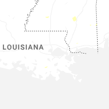
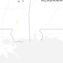
Louisiana
| Local Time | Report Details |
|---|---|
| 1:35 PM CDT | 2 trees downed along hwy 61 in webster county LA, 42.2 miles NE of Shreveport, LA |
| 1:35 PM CDT | Corrects previous tstm wnd dmg report from 3 ene shongaloo. 2 trees downed along hwy 61 in webster county LA, 42.7 miles NE of Shreveport, LA |
| 2:30 PM CDT | Trees down across claiborne paris in claiborne county LA, 42.6 miles ENE of Shreveport, LA |
| 2:37 PM CDT | Tree down on whispering pine driv in bossier county LA, 10.3 miles ENE of Shreveport, LA |
| 3:00 PM CDT | Very large tree fell on a home on fairfield avenue in shreveport... resulting in significant damag in caddo county LA, 4.5 miles S of Shreveport, LA |
| 3:45 PM CDT | 911 dispatch reported trees down across the parish. time estimated by rada in de soto county LA, 33.5 miles S of Shreveport, LA |
| 5:24 PM CDT | Powerline downed by thunderstorm wind in livingston county LA, 55.1 miles NW of New Orleans, LA |
| 7:10 PM CDT | Report from beauregard parish sheriffs office of a tree down on longville church roa in beauregard county LA, 43.9 miles NE of Beaumont, TX |
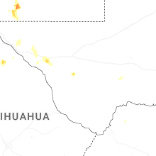
New Mexico
| Local Time | Report Details |
|---|---|
| 1:25 PM MDT | Ping Pong Ball sized hail reported near Cloudcroft, NM, 66.9 miles WSW of Roswell, NM |
| 3:30 PM MDT | Tea Cup sized hail reported near Mayhill, NM, 65.5 miles WSW of Roswell, NM |
| 4:07 PM MDT | Quarter sized hail reported near Chacon, NM, 21.4 miles SE of Taos, NM, time estimated based on radar. |
| 4:12 PM MDT | Storm damage reported in de baca county NM, 50.3 miles SW of Tucumcari, NM |
| 6:41 PM MDT | Mesonet at carlsbad caverns np recorded a thunderstorm wind gust of 73 mp in eddy county NM, 84.4 miles S of Roswell, NM |
| 6:55 PM MDT | Artesia awos recorded a thunderstorm wind gust of 62 mp in eddy county NM, 37.7 miles S of Roswell, NM |
| 6:55 PM MDT | Seven rivers weather station recorded a thunderstorm wind gust of 66 mp in eddy county NM, 51.5 miles S of Roswell, NM |
Wyoming
| Local Time | Report Details |
|---|---|
| 1:40 PM MDT | Mesonet station pc229 little bitter creek (pc in sweetwater county WY, 15.8 miles S of Rock Springs, WY |
| 4:14 PM MDT | Ping Pong Ball sized hail reported near Lusk, WY, 76 miles SW of Rapid City, SD, delayed report. hail of at least ping pong ball sized was found 2-3 hours after the storm. hail accumulation covered the ground and drifts of up to 1 to 2 feet deep wer |
| 5:46 PM MDT | Mesonet station ktmh i-25 twenty mile hill (dot in natrona county WY, 18.6 miles N of Casper, WY |
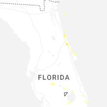
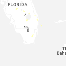
Florida
| Local Time | Report Details |
|---|---|
| 3:45 PM EDT | Broadcast media relayed photo of a fallen large pine tree in century village west palm beach due to severe wind gusts with a severe thunderstorm that over the location in palm beach county FL, 40.8 miles SSE of Port Saint Lucie, FL |
| 5:26 PM EDT | Quarter sized hail reported near New Smyrna Beach, FL, 40.8 miles NE of Orlando, FL, broadcast media relayed picture of quarter size hail in new smyrna beach in the oliver estates subdivision near s glencoe rd. |
| 5:40 PM EDT | Ormond beach municipal airport measured a peak wind gust of 61mph/53kt from the east at 5:40 p in volusia county FL, 54.7 miles NNE of Orlando, FL |
| 5:45 PM EDT | Tree damage and roof damage at alan jay chevy gmc in sebrin in highlands county FL, 67.4 miles E of Bradenton, FL |
| 6:11 PM EDT | Off duty nws employee shared photos of a large tree down on the northbound lanes of northwest 102nd avenue in doral... florida as a result of severe wind gusts as a sev in miami-dade county FL, 9.9 miles NW of Miami, FL |
| 6:30 PM EDT | The weatherstem station at ponce inlet town hall measured a peak wind gust of 63mph/55kt from the southeast at 6:30 p in volusia county FL, 47.7 miles NNE of Orlando, FL |
| 8:15 PM EDT | Broadcast media shared photos of a large tree down and trampoline stuck onto a roof after a severe thunderstorm moved through the arden community in palm beach count in palm beach county FL, 40.2 miles S of Port Saint Lucie, FL |
| 8:55 PM EDT | Port meteorological officer on u.s. training ship state of maine reported a peak wind gust of 62mph as a thunderstorm was moving over the gulfstream. a peak sustained w in amz671 county FL, 33.3 miles ESE of Miami, FL |
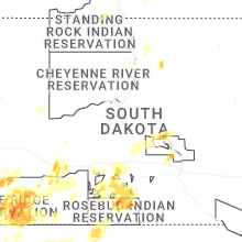
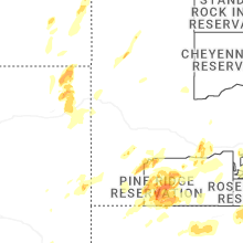
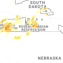
South Dakota
| Local Time | Report Details |
|---|---|
| 2:19 PM MDT | Golf Ball sized hail reported near Philip, SD, 68.4 miles ESE of Rapid City, SD |
| 2:21 PM MDT | Golf Ball sized hail reported near Philip, SD, 68.6 miles ESE of Rapid City, SD, falling at the conoco gas station. time estimated based on radar and social media video. |
| 2:25 PM MDT | Ping Pong Ball sized hail reported near Oglala, SD, 65.9 miles SSE of Rapid City, SD, small hail beginning to accumulate. |
| 2:42 PM MDT | Storm damage reported in jackson county SD, 72.3 miles ESE of Rapid City, SD |
| 2:46 PM MDT | Quarter sized hail reported near Oglala, SD, 66.3 miles SSE of Rapid City, SD |
| 3:07 PM MDT | Quarter sized hail reported near Oglala, SD, 66.5 miles SSE of Rapid City, SD |
| 3:39 PM MDT | Quarter sized hail reported near Wanblee, SD, 75.1 miles ESE of Rapid City, SD |
| 5:17 PM CDT | Quarter sized hail reported near Hoven, SD, 64.3 miles WSW of Aberdeen, SD, estimated nickel to quarter size hail. |
| 4:25 PM MDT | Storm damage reported in oglala lakota county SD, 70.1 miles SSE of Rapid City, SD |
| 5:33 PM MDT | Storm damage reported in jackson county SD, 49.4 miles SW of Pierre, SD |
| 5:38 PM MDT | Storm damage reported in jackson county SD, 49.4 miles SW of Pierre, SD |
| 6:43 PM CDT | Ping Pong Ball sized hail reported near White River, SD, 49 miles N of Valentine, NE, estimated ping pong ball size hail... zero visibility... very strong winds at least over 60 mph rocking truck back and forth. street flooding now occurring across white |
| 6:43 PM CDT | Estimated ping pong ball size hail... zero visibility... very strong winds at least over 60 mph rocking truck back and forth. street flooding now occurring across white in mellette county SD, 49 miles N of Valentine, NE |
| 7:33 PM CDT | Mesonet station 13 vivian (sddot in lyman county SD, 22 miles S of Pierre, SD |
| 8:29 PM CDT | Golf Ball sized hail reported near Mission, SD, 27.5 miles NNE of Valentine, NE, picture submitted via social media. |
| 9:58 PM CDT | Golf Ball sized hail reported near Mission, SD, 30.7 miles N of Valentine, NE |
| 9:58 PM CDT | Storm damage reported in todd county SD, 30.7 miles N of Valentine, NE |
West Virginia
| Local Time | Report Details |
|---|---|
| 5:10 PM EDT | Tree contact with power lines. tree down due to high win in mcdowell county WV, 64.1 miles NE of Bristol, TN |
Montana
| Local Time | Report Details |
|---|---|
| 7:40 PM MDT | Tea Cup sized hail reported near Baker, MT, 89.2 miles ESE of Miles City, MT |
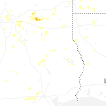
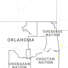
Oklahoma
| Local Time | Report Details |
|---|---|
| 10:16 PM CDT | Kmko observatio in muskogee county OK, 48.6 miles SE of Tulsa, OK |
Connect with Interactive Hail Maps