

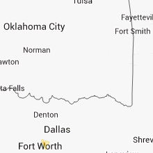
Hail Map for Wednesday, August 14, 2013

Number of Impacted Households on 8/14/2013
0
Impacted by 1" or Larger Hail
0
Impacted by 1.75" or Larger Hail
0
Impacted by 2.5" or Larger Hail
Square Miles of Populated Area Impacted on 8/14/2013
0
Impacted by 1" or Larger Hail
0
Impacted by 1.75" or Larger Hail
0
Impacted by 2.5" or Larger Hail


Cities Most Affected by Hail Storms of 8/14/2013
| Hail Size | Demographics of Zip Codes Affected | ||||||
|---|---|---|---|---|---|---|---|
| City | Count | Average | Largest | Pop Density | House Value | Income | Age |
| Sanford, TX | 2 | 1.75 | 1.75 | 0 | $30k | $29.9k | 48.4 |
| Plainview, TX | 1 | 1.75 | 1.75 | 68 | $57k | $31.5k | 31.2 |
| Stinnett, TX | 1 | 1.75 | 1.75 | 1 | $40k | $33.7k | 38.0 |
| Manter, KS | 1 | 1.75 | 1.75 | 0 | $75k | $43.8k | 43.6 |
Hail and Wind Damage Spotted on 8/14/2013
Filter by Report Type:Hail ReportsWind Reports
States Impacted
Maine, Kansas, Georgia, Texas, South Carolina, Oklahoma, Florida, Colorado, Wyoming, MontanaMaine
| Local Time | Report Details |
|---|---|
| 1:30 PM EDT | Trees down in piscataquis county ME, 42.7 miles NW of Bangor, ME |
| 1:30 PM EDT | Trees down in piscataquis county ME, 37.3 miles NNW of Bangor, ME |
Kansas
| Local Time | Report Details |
|---|---|
| 2:46 PM CDT | Golf Ball sized hail reported near Manter, KS, 67.3 miles WSW of Garden City, KS, the hail was observed along highway 160. |
| 3:00 PM CDT | Storm damage reported in stanton county KS, 73.6 miles WSW of Garden City, KS |
| 3:30 PM CDT | Ping Pong Ball sized hail reported near Richfield, KS, 79.4 miles SW of Garden City, KS, there were also 3 evergreen trees upr |
| 3:45 PM CDT | Winds were estimated to be 60 to 70 mp in morton county KS, 81.8 miles SW of Garden City, KS |
| 3:49 PM CDT | Storm damage reported in morton county KS, 87.1 miles SW of Garden City, KS |
| 4:00 PM CDT | Storm damage reported in morton county KS, 81.8 miles SW of Garden City, KS |
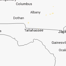
Georgia
| Local Time | Report Details |
|---|---|
| 4:15 PM EDT | Tree down near u.s. 84 and old naylor roa in lowndes county GA, 44.9 miles SSW of Douglas, GA |
| 6:40 PM EDT | Numerous trees reported down in hazlehurs in jeff davis county GA, 29.1 miles NNE of Douglas, GA |
| 6:40 PM EDT | Trees and power lines down along highway 107 between snipesville and douglas highwa in jeff davis county GA, 18.9 miles NNE of Douglas, GA |
| 6:50 PM EDT | Tree was reported down at the intersection of knox road and ham roa in brantley county GA, 60.2 miles NNW of Jacksonville, FL |
| 7:05 PM EDT | Dispatch received numerous reports of trees down across glynn count in glynn county GA, 62.1 miles SSW of Savannah, GA |
| 7:46 PM EDT | Spotter reported a few trees down on highway 99 in meridia in mcintosh county GA, 46.7 miles SSW of Savannah, GA |
| 7:50 PM EDT | Power line down second west street near highway 1 in mcintosh county GA, 53.1 miles SSW of Savannah, GA |
| 8:45 PM EDT | One tree down on joe shingler roa in miller county GA, 57 miles NNW of Tallahassee, FL |
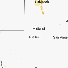
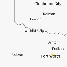
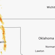
Texas
| Local Time | Report Details |
|---|---|
| 3:30 PM CDT | Very strong thunderstorm winds over the westwood shores area of lake livingsto in trinity county TX, 46.1 miles SW of Lufkin, TX |
| 5:55 PM CDT | Horse trailers blown over by thunderstorm winds estimated at 60 mp in sherman county TX, 71.9 miles N of Amarillo, TX |
| 6:43 PM CDT | Quarter sized hail reported near Morse, TX, 62.3 miles NNE of Amarillo, TX |
| 6:55 PM CDT | Golf Ball sized hail reported near Stinnett, TX, 46.2 miles NNE of Amarillo, TX |
| 6:57 PM CDT | Quarter sized hail reported near , , 46.1 miles NNE of Amarillo, TX |
| 7:17 PM CDT | Golf Ball sized hail reported near Sanford, TX, 38.1 miles NNE of Amarillo, TX |
| 7:21 PM CDT | Golf Ball sized hail reported near Sanford, TX, 38.2 miles NNE of Amarillo, TX, damage to several automobile wind shields. |
| 7:25 PM CDT | Storm damage reported in hutchinson county TX, 39.7 miles NE of Amarillo, TX |
| 7:29 PM CDT | Storm damage reported in hutchinson county TX, 32.6 miles NNE of Amarillo, TX |
| 7:29 PM CDT | Damage to carports and weak structures in lake meredith area. winds estimated at 75 mp in hutchinson county TX, 32.6 miles NNE of Amarillo, TX |
| 7:29 PM CDT | Quarter sized hail reported near Fritch, TX, 32.6 miles NNE of Amarillo, TX, quarter size hail reported in the lake meredith area. |
| 7:34 PM CDT | Storm damage reported in hutchinson county TX, 38.6 miles NE of Amarillo, TX |
| 8:10 PM CDT | Quarter sized hail reported near Panhandle, TX, 27.5 miles ENE of Amarillo, TX |
| 8:45 PM CDT | Storm damage reported in armstrong county TX, 26.6 miles ESE of Amarillo, TX |
| 9:00 PM CDT | Ping Pong Ball sized hail reported near Claude, TX, 27.7 miles ESE of Amarillo, TX |
| 9:25 PM CDT | Ping Pong Ball sized hail reported near Claude, TX, 35.4 miles SE of Amarillo, TX, at hwy 207 crossing of prairie dog town fork of the red river. |
| 9:51 PM CDT | Quarter sized hail reported near Plainview, TX, 42.5 miles N of Lubbock, TX |
| 9:51 PM CDT | Storm damage reported in hale county TX, 42.5 miles N of Lubbock, TX |
| 10:19 PM CDT | Golf Ball sized hail reported near Plainview, TX, 41.2 miles N of Lubbock, TX |
| 1:21 AM CDT | Wind speed was estimated to be at least 60 mph in hockley county TX, 20.5 miles WSW of Lubbock, TX |
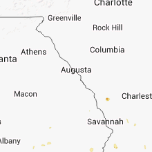
South Carolina
| Local Time | Report Details |
|---|---|
| 4:31 PM EDT | Quarter sized hail reported near Early Branch, SC, 47.1 miles NNE of Savannah, GA, emergency manager relayed a report of greater than 1 inch hail in early branch. |
| 5:41 PM EDT | Tree down along parris island gateway road. time estimated from rada in beaufort county SC, 31 miles NE of Savannah, GA |
Oklahoma
| Local Time | Report Details |
|---|---|
| 4:50 PM CDT | Estimated 60 to 70 mph winds. time estimated based on radar in texas county OK, 96.1 miles SSW of Garden City, KS |
| 4:50 PM CDT | Estimated 60 to 70 mph winds. time estimated based on rada in texas county OK, 96.1 miles SSW of Garden City, KS |
Florida
| Local Time | Report Details |
|---|---|
| 6:15 PM EDT | Emergency manager reports 2 or 3 trees blown into power lines at black point road and state road 100 west of bunnel in flagler county FL, 63.3 miles SSE of Jacksonville, FL |
| 6:27 PM EDT | Tree down across road on power lines at 31 porcupine drive in palm coas in flagler county FL, 63.5 miles SSE of Jacksonville, FL |
| 6:44 PM EDT | Flagler county dispatch reports a tree down across sawgrass road near bunnel in flagler county FL, 62.2 miles SSE of Jacksonville, FL |
| 6:52 PM EDT | Tree down across state road 100 in andalusi in flagler county FL, 59 miles S of Jacksonville, FL |
| 8:15 PM EDT | Large tree down in arlington area blocking road. time based on rada in duval county FL, 3.4 miles E of Jacksonville, FL |
Colorado
| Local Time | Report Details |
|---|---|
| 5:37 PM MDT | Quarter sized hail reported near Colorado Springs, CO, 46.8 miles N of Pueblo, CO |
| 5:46 PM MDT | Half Dollar sized hail reported near Colorado Springs, CO, 47.8 miles N of Pueblo, CO |
| 7:35 PM MDT | Quarter sized hail reported near Pueblo, CO, 8.8 miles WNW of Pueblo, CO |
| 7:35 PM MDT | Quarter sized hail reported near Pueblo, CO, 7.9 miles WNW of Pueblo, CO |
| 7:47 PM MDT | Quarter sized hail reported near Pueblo, CO, 3.3 miles WSW of Pueblo, CO, dents in car and shredded leaves on vegetation. |
| 7:54 PM MDT | Quarter sized hail reported near Pueblo, CO, 3.1 miles WSW of Pueblo, CO |
| 7:55 PM MDT | Quarter sized hail reported near Pueblo, CO, 3.6 miles WSW of Pueblo, CO |
| 8:15 PM MDT | Storm damage reported in logan county CO, 46 miles NW of Yuma, CO |
| 8:18 PM MDT | Several large trees blown over in the town of sterling in logan county CO, 44.8 miles NW of Yuma, CO |
Wyoming
| Local Time | Report Details |
|---|---|
| 6:25 PM MDT | Quarter sized hail reported near Upton, WY, 45.7 miles ESE of Gillette, WY |
Montana
| Local Time | Report Details |
|---|---|
| 7:05 PM MDT | Quarter sized hail reported near Olive, MT, 58.4 miles SSE of Miles City, MT, hail size was mostly pea size but did have a few quarter size stones. |
Connect with Interactive Hail Maps