

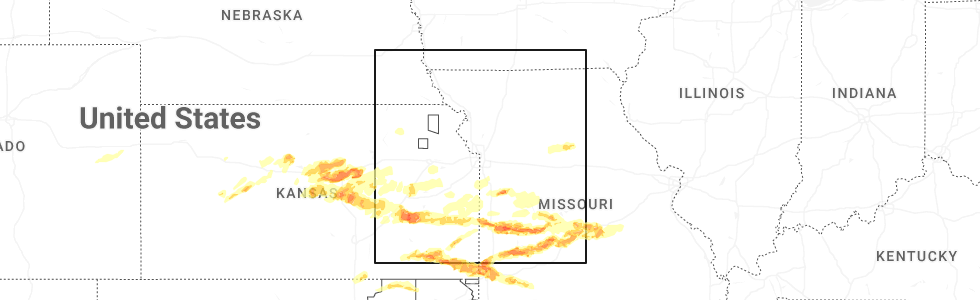
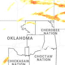
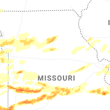
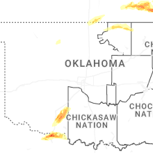
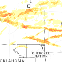
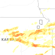
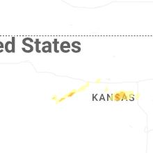
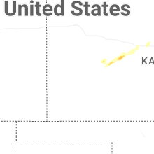
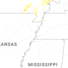
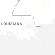
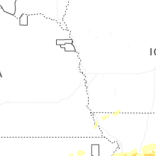
Hail Map for Sunday, April 26, 2026
Number of Impacted Households on 4/26/2026
0
Impacted by 1" or Larger Hail
0
Impacted by 1.75" or Larger Hail
0
Impacted by 2.5" or Larger Hail
Square Miles of Populated Area Impacted on 4/26/2026
0
Impacted by 1" or Larger Hail
0
Impacted by 1.75" or Larger Hail
0
Impacted by 2.5" or Larger Hail


Cities Most Affected by Hail Storms of 4/26/2026
| Hail Size | Demographics of Zip Codes Affected | ||||||
|---|---|---|---|---|---|---|---|
| City | Count | Average | Largest | Pop Density | House Value | Income | Age |
| Salina, KS | 5 | 2.00 | 2.00 | 216 | $86k | $37.0k | 37.3 |
| Farmington, MO | 5 | 1.90 | 2.00 | 112 | $85k | $32.4k | 39.5 |
| El Dorado Springs, MO | 4 | 2.13 | 2.75 | 31 | $53k | $25.0k | 43.6 |
| Lawton, OK | 3 | 2.42 | 2.75 | 126 | $66k | $30.3k | 34.5 |
| Nevada, MO | 3 | 1.92 | 2.00 | 91 | $65k | $30.9k | 40.0 |
| Wichita Falls, TX | 3 | 1.92 | 2.25 | 60 | $66k | $34.6k | 41.7 |
| Cherryvale, KS | 2 | 2.88 | 3.00 | 29 | $36k | $30.7k | 40.4 |
| Greenfield, MO | 3 | 1.83 | 2.00 | 28 | $60k | $25.9k | 47.6 |
| Sycamore, KS | 2 | 2.50 | 2.50 | 0 | $104k | $40.6k | 55.5 |
| Iowa Park, TX | 2 | 2.38 | 3.00 | 48 | $60k | $42.2k | 39.7 |
| Humansville, MO | 2 | 2.38 | 2.75 | 26 | $44k | $24.9k | 43.1 |
| Mcpherson, KS | 2 | 1.75 | 1.75 | 67 | $86k | $42.0k | 39.9 |
| Stockton, MO | 1 | 2.75 | 2.75 | 22 | $71k | $30.9k | 47.3 |
| Creighton, MO | 1 | 2.50 | 2.50 | 19 | $60k | $42.3k | 41.6 |
| Walker, MO | 1 | 2.50 | 2.50 | 10 | $44k | $29.6k | 41.2 |
| Garden City, MO | 1 | 2.00 | 2.00 | 29 | $84k | $41.3k | 38.9 |
| Madison, KS | 1 | 2.00 | 2.00 | 3 | $33k | $31.8k | 45.2 |
| Lindsborg, KS | 1 | 2.00 | 2.00 | 29 | $84k | $40.9k | 40.5 |
| Pittsburg, MO | 1 | 2.00 | 2.00 | 70 | $69k | $23.9k | 58.0 |
| Irondale, MO | 1 | 2.00 | 2.00 | 41 | $44k | $31.2k | 38.4 |
| Dowell, IL | 1 | 1.75 | 1.75 | 0 | $25k | $24.5k | 40.2 |
| Hillsboro, KS | 1 | 1.75 | 1.75 | 26 | $67k | $35.2k | 40.2 |
| Vergennes, IL | 1 | 1.75 | 1.75 | 17 | $47k | $34.9k | 39.3 |
| Morrisville, MO | 1 | 1.75 | 1.75 | 40 | $65k | $33.8k | 39.7 |
| Burkburnett, TX | 1 | 1.75 | 1.75 | 148 | $64k | $38.5k | 38.2 |
| Topeka, KS | 1 | 1.75 | 1.75 | 131 | $108k | $60.4k | 40.0 |
| Lenexa, KS | 1 | 1.75 | 1.75 | 382 | $154k | $67.0k | 38.1 |
| Caledonia, MO | 1 | 1.75 | 1.75 | 18 | $69k | $30.2k | 43.3 |
| Walnut Grove, MO | 1 | 1.75 | 1.75 | 30 | $62k | $34.5k | 41.0 |
| Erie, KS | 1 | 1.75 | 1.75 | 15 | $44k | $32.1k | 43.7 |
Hail and Wind Damage Spotted on 4/26/2026
Filter by Report Type:Hail ReportsWind Reports
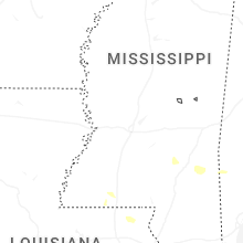
Mississippi
| Local Time | Report Details |
|---|---|
| 7:00 AM CDT | Scattered trees were reported down by the lincoln county e in lincoln county MS, 59.8 miles SSW of Jackson, MS |
| 7:12 AM CDT | Scattered trees were reported down by the lincoln county e in lincoln county MS, 62.9 miles S of Jackson, MS |
| 5:59 PM CDT | Quarter sized hail reported near Purvis, MS, 84.1 miles SSE of Jackson, MS, fell along burnt bridge rd. |
| 6:05 PM CDT | Ping Pong Ball sized hail reported near Purvis, MS, 85.9 miles SSE of Jackson, MS, social media reports from between purvis and oak grove. |
| 6:07 PM CDT | Half Dollar sized hail reported near Purvis, MS, 86.8 miles SSE of Jackson, MS, social media pictures from along old hwy 11. |
| 6:15 PM CDT | Quarter sized hail reported near Purvis, MS, 86.1 miles WNW of Mobile, AL |
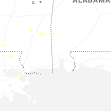
Louisiana
| Local Time | Report Details |
|---|---|
| 8:28 AM CDT | Half Dollar sized hail reported near Mooringsport, LA, 16.8 miles NW of Shreveport, LA, hail size of at least half dollar size was reported in the town of mooringsport. |
| 8:30 AM CDT | A large tree fell across la-highway 169 near the intersection of la-highway 538... downing powerlines and blocking traffi in caddo county LA, 17.3 miles NW of Shreveport, LA |
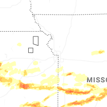
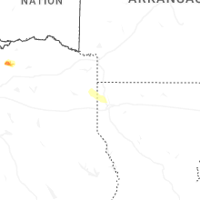
Kansas
| Local Time | Report Details |
|---|---|
| 9:55 AM CDT | Damaged and broken power poles reported in columbus... k in cherokee county KS, 48.8 miles SE of Chanute, KS |
| 11:06 AM CDT | Quarter sized hail reported near Geneseo, KS, 67.8 miles ESE of Hays, KS |
| 12:05 PM CDT | Golf Ball sized hail reported near Mcpherson, KS, 56.3 miles NNW of Wichita, KS |
| 12:08 PM CDT | Quarter sized hail reported near Mcpherson, KS, 50.8 miles NNW of Wichita, KS |
| 12:18 PM CDT | Quarter sized hail reported near Galva, KS, 50.2 miles NNW of Wichita, KS, delayed report from mping. |
| 12:29 PM CDT | Quarter sized hail reported near Gypsum, KS, 51.7 miles SW of Manhattan, KS |
| 12:30 PM CDT | Half Dollar sized hail reported near Mcpherson, KS, 54.9 miles NNW of Wichita, KS, time estimated from radar. |
| 12:32 PM CDT | Half Dollar sized hail reported near Canton, KS, 48.8 miles N of Wichita, KS, half dollar hail size piling up. |
| 12:32 PM CDT | Storm damage reported in mcpherson county KS, 48.8 miles N of Wichita, KS |
| 12:45 PM CDT | Quarter sized hail reported near Lehigh, KS, 47.1 miles N of Wichita, KS, quarter size according to fire chief. |
| 12:50 PM CDT | Quarter sized hail reported near Hope, KS, 40.8 miles SW of Manhattan, KS |
| 12:52 PM CDT | Quarter sized hail reported near Hillsboro, KS, 44.5 miles N of Wichita, KS, piles of quarter size hail. |
| 12:55 PM CDT | Golf Ball sized hail reported near Hillsboro, KS, 46.3 miles N of Wichita, KS |
| 12:57 PM CDT | Report of tree through roof at house in lehig in marion county KS, 47.1 miles N of Wichita, KS |
| 1:06 PM CDT | Ping Pong Ball sized hail reported near Canton, KS, 48.8 miles N of Wichita, KS, delayed report from mping: ping pong ball (1.50 in.). |
| 1:08 PM CDT | Quarter sized hail reported near White City, KS, 29.6 miles SSW of Manhattan, KS |
| 1:13 PM CDT | Quarter sized hail reported near Hillsboro, KS, 46.2 miles N of Wichita, KS |
| 1:13 PM CDT | Quarter sized hail reported near Marion, KS, 47.2 miles NNE of Wichita, KS, delayed report of 1 inch hail. |
| 1:23 PM CDT | Half Dollar sized hail reported near Marion, KS, 48.9 miles NNE of Wichita, KS, picture of 1 1/4 inch hail. |
| 1:32 PM CDT | Quarter sized hail reported near Florence, KS, 44.1 miles NNE of Wichita, KS |
| 2:15 PM CDT | Quarter sized hail reported near Mcpherson, KS, 56.8 miles NNW of Wichita, KS, delayed report from mping. |
| 2:34 PM CDT | Quarter sized hail reported near Cassoday, KS, 45.4 miles ENE of Wichita, KS |
| 2:37 PM CDT | Ping Pong Ball sized hail reported near Cassoday, KS, 43.1 miles ENE of Wichita, KS, delayed report from mping. |
| 3:03 PM CDT | Quarter sized hail reported near Madison, KS, 51.7 miles NW of Chanute, KS |
| 3:03 PM CDT | Measured with hand held anemomete in osage county KS, 56.2 miles SE of Manhattan, KS |
| 3:08 PM CDT | Hen Egg sized hail reported near Madison, KS, 48.7 miles NW of Chanute, KS |
| 3:17 PM CDT | Golf Ball sized hail reported near Erie, KS, 14 miles ESE of Chanute, KS, public report of hail between 1.5 and 2 inches in diameter or just slightly smaller than a golf ball. |
| 3:29 PM CDT | Half Dollar sized hail reported near Gridley, KS, 37.1 miles NW of Chanute, KS |
| 3:34 PM CDT | Storm damage reported in osage county KS, 61.2 miles SE of Manhattan, KS |
| 3:45 PM CDT | Storm damage reported in woodson county KS, 27.3 miles NW of Chanute, KS |
| 3:48 PM CDT | Quarter sized hail reported near Le Roy, KS, 32.8 miles NNW of Chanute, KS |
| 3:49 PM CDT | Estimated 65 mph with pea sized hai in woodson county KS, 27.3 miles NW of Chanute, KS |
| 3:52 PM CDT | Ping Pong Ball sized hail reported near Gridley, KS, 37.8 miles NW of Chanute, KS |
| 3:52 PM CDT | Ping Pong Ball sized hail reported near Le Roy, KS, 27.7 miles NNW of Chanute, KS |
| 3:52 PM CDT | Quarter sized hail reported near Yates Center, KS, 27.3 miles NW of Chanute, KS |
| 4:03 PM CDT | 80+ mph winds estimated with quarter sized hail reported 9 ne of yates cente in woodson county KS, 24.8 miles NNW of Chanute, KS |
| 4:07 PM CDT | 0.5 inch hai in anderson county KS, 28.8 miles N of Chanute, KS |
| 4:12 PM CDT | Quarter sized hail reported near Fort Scott, KS, 42 miles ENE of Chanute, KS, social media picture of quarter size hail in fort scott... kansas. |
| 4:13 PM CDT | Quarter sized hail reported near Iola, KS, 19.9 miles N of Chanute, KS |
| 4:18 PM CDT | Quarter sized hail reported near Iola, KS, 21.2 miles N of Chanute, KS, quarter hail broke one glass window. |
| 4:20 PM CDT | Homes damaged and barn destroyed. time estimated from rada in miami county KS, 38.5 miles SW of Kansas City, MO |
| 4:29 PM CDT | Several downed trees southwest of hillsdale lake. time estimated from rada in miami county KS, 35.5 miles SSW of Kansas City, MO |
| 4:38 PM CDT | Private weather senso in miami county KS, 37.7 miles SSW of Kansas City, MO |
| 4:40 PM CDT | Report via personal weather statio in miami county KS, 36.7 miles SSW of Kansas City, MO |
| 4:56 PM CDT | Corrects previous tstm wnd dmg report from bucyrus. downed trees and blown down fence at a residence near bucyrus. time estimated from rada in miami county KS, 26.8 miles SSW of Kansas City, MO |
| 4:59 PM CDT | Downed wires and power outages near delmont drive. time estimated from rada in linn county KS, 47.4 miles NE of Chanute, KS |
| 5:03 PM CDT | Downed wires near belleview road. time estimated from rada in miami county KS, 34.1 miles S of Kansas City, MO |
| 5:15 PM CDT | Downed wires and power outages near watties road. time estimated from rada in linn county KS, 54 miles NE of Chanute, KS |
| 7:13 PM CDT | Time estimated from rada in montgomery county KS, 28.4 miles SSW of Chanute, KS |
| 7:15 PM CDT | Tennis Ball sized hail reported near Sycamore, KS, 28.4 miles SSW of Chanute, KS |
| 7:17 PM CDT | Tennis Ball sized hail reported near Sycamore, KS, 28.4 miles SSW of Chanute, KS |
| 7:31 PM CDT | Baseball sized hail reported near Cherryvale, KS, 25 miles SSW of Chanute, KS, report from mping: baseball (2.75 in.). |
| 7:31 PM CDT | Tea Cup sized hail reported near Cherryvale, KS, 28.5 miles SSW of Chanute, KS |
| 8:26 PM CDT | Quarter sized hail reported near Longton, KS, 40.3 miles WSW of Chanute, KS |
| 9:28 PM CDT | Several tree limbs down along with power poles and power line in labette county KS, 40 miles SSE of Chanute, KS |
| 9:49 PM CDT | Multiple trees downed including tress on house in cherokee county KS, 43.2 miles SE of Chanute, KS |
| 10:21 PM CDT | Downed trees and blown down fence at a residence near bucyrus. time estimated from rada in miami county KS, 26.8 miles SSW of Kansas City, MO |
| 11:35 PM CDT | Golf Ball sized hail reported near Mcpherson, KS, 54.9 miles NNW of Wichita, KS |
| 11:35 PM CDT | Quarter sized hail reported near Lindsborg, KS, 59.6 miles NNW of Wichita, KS |
| 11:35 PM CDT | Quarter sized hail reported near Mcpherson, KS, 56.6 miles NNW of Wichita, KS, report from mping: quarter (1.00 in.). |
| 11:35 PM CDT | Quarter sized hail reported near Lindsborg, KS, 58 miles NNW of Wichita, KS |
| 11:39 PM CDT | Quarter sized hail reported near Lindsborg, KS, 61.5 miles NNW of Wichita, KS |
| 11:46 PM CDT | Ping Pong Ball sized hail reported near Ellsworth, KS, 60.2 miles E of Hays, KS |
| 11:50 PM CDT | Quarter sized hail reported near Ellsworth, KS, 65.5 miles E of Hays, KS |
| 12:00 AM CDT | Hen Egg sized hail reported near Salina, KS, 61.5 miles WSW of Manhattan, KS |
| 12:08 AM CDT | Quarter sized hail reported near Brookville, KS, 74.5 miles NNW of Wichita, KS |
| 12:10 AM CDT | Quarter sized hail reported near Herington, KS, 42.3 miles SW of Manhattan, KS, also estimated wind gusts of 45 to 55 mph. |
| 12:23 AM CDT | Half Dollar sized hail reported near Lindsborg, KS, 69 miles WSW of Manhattan, KS |
| 12:27 AM CDT | Hen Egg sized hail reported near Salina, KS, 64.2 miles WSW of Manhattan, KS |
| 12:27 AM CDT | Ping Pong Ball sized hail reported near Salina, KS, 61.3 miles WSW of Manhattan, KS |
| 12:28 AM CDT | Hen Egg sized hail reported near Lindsborg, KS, 68.1 miles WSW of Manhattan, KS |
| 12:29 AM CDT | Ping Pong Ball sized hail reported near Salina, KS, 63.3 miles WSW of Manhattan, KS |
| 12:30 AM CDT | Quarter sized hail reported near Salina, KS, 61.1 miles WSW of Manhattan, KS, report from mping: quarter (1.00 in.). |
| 12:31 AM CDT | Hen Egg sized hail reported near Salina, KS, 62.5 miles WSW of Manhattan, KS, report from mping: hen egg (2.00 in.). |
| 12:32 AM CDT | Quarter sized hail reported near Salina, KS, 61.7 miles WSW of Manhattan, KS, report from mping: quarter (1.00 in.). |
| 12:34 AM CDT | Half Dollar sized hail reported near Salina, KS, 62.7 miles WSW of Manhattan, KS, report from mping: half dollar (1.25 in.). |
| 12:37 AM CDT | Hen Egg sized hail reported near Salina, KS, 61.1 miles WSW of Manhattan, KS, report from mping: hen egg (2.00 in.). |
| 12:41 AM CDT | Hen Egg sized hail reported near Salina, KS, 62.2 miles WSW of Manhattan, KS, report from mping: hen egg (2.00 in.). |
| 12:46 AM CDT | Quarter sized hail reported near Solomon, KS, 47 miles WSW of Manhattan, KS |
| 12:48 AM CDT | Quarter sized hail reported near Russell, KS, 27 miles ENE of Hays, KS |
| 12:54 AM CDT | Quarter sized hail reported near Salina, KS, 59.9 miles WSW of Manhattan, KS, report from mping: quarter (1.00 in.). |
| 1:01 AM CDT | Half Dollar sized hail reported near Arkansas City, KS, 44.5 miles SSE of Wichita, KS |
| 1:02 AM CDT | Quarter sized hail reported near Arkansas City, KS, 44.7 miles SSE of Wichita, KS, report from mping: quarter (1.00 in.). |
| 1:02 AM CDT | Ping Pong Ball sized hail reported near Arkansas City, KS, 46.2 miles SSE of Wichita, KS |
| 1:03 AM CDT | Half Dollar sized hail reported near Arkansas City, KS, 44.7 miles SSE of Wichita, KS |
| 1:03 AM CDT | Ping Pong Ball sized hail reported near Arkansas City, KS, 45.6 miles SSE of Wichita, KS |
| 1:15 AM CDT | Ping Pong Ball sized hail reported near Lucas, KS, 44.6 miles ENE of Hays, KS |
| 1:28 AM CDT | Quarter sized hail reported near Junction City, KS, 19.4 miles SW of Manhattan, KS |
| 1:29 AM CDT | Quarter sized hail reported near Sylvan Grove, KS, 53.1 miles ENE of Hays, KS |
| 1:37 AM CDT | Quarter sized hail reported near Alta Vista, KS, 21.6 miles S of Manhattan, KS |
| 1:58 AM CDT | Quarter sized hail reported near Burrton, KS, 29.4 miles NW of Wichita, KS, off-duty nws employee. |
| 2:20 AM CDT | Lawn furniture is being blown around and things knocking into the hous in wabaunsee county KS, 34.4 miles ESE of Manhattan, KS |
| 2:30 AM CDT | Personal weather statio in shawnee county KS, 41.5 miles ESE of Manhattan, KS |
| 2:40 AM CDT | Quarter sized hail reported near Topeka, KS, 42.4 miles ESE of Manhattan, KS |
| 2:42 AM CDT | Ktop aso in shawnee county KS, 50.6 miles E of Manhattan, KS |
| 2:45 AM CDT | Quarter sized hail reported near Maple Hill, KS, 34.4 miles ESE of Manhattan, KS, also estimating 50 mph winds with the hail. |
| 2:48 AM CDT | Quarter sized hail reported near Topeka, KS, 47.4 miles ESE of Manhattan, KS |
| 2:48 AM CDT | Personal weather statio in shawnee county KS, 40.1 miles ESE of Manhattan, KS |
| 2:49 AM CDT | Quarter sized hail reported near Topeka, KS, 42.9 miles ESE of Manhattan, KS, report from mping: quarter (1.00 in.). |
| 2:50 AM CDT | Ping Pong Ball sized hail reported near Topeka, KS, 45.3 miles E of Manhattan, KS |
| 2:50 AM CDT | Golf Ball sized hail reported near Topeka, KS, 45.1 miles E of Manhattan, KS |
| 2:50 AM CDT | Personal weather statio in shawnee county KS, 45.5 miles E of Manhattan, KS |
| 2:52 AM CDT | Storm damage reported in shawnee county KS, 48.3 miles E of Manhattan, KS |
| 2:53 AM CDT | Quarter sized hail reported near Topeka, KS, 46.1 miles E of Manhattan, KS, report from mping: quarter (1.00 in.). |
| 2:54 AM CDT | Quarter sized hail reported near Topeka, KS, 50.6 miles E of Manhattan, KS, at the nws office. |
| 2:57 AM CDT | Quarter sized hail reported near Topeka, KS, 51.8 miles ESE of Manhattan, KS, report from mping: quarter (1.00 in.). |
| 2:57 AM CDT | Quarter sized hail reported near Topeka, KS, 42.4 miles ESE of Manhattan, KS |
| 2:58 AM CDT | Quarter sized hail reported near Topeka, KS, 46.9 miles E of Manhattan, KS, report from mping: quarter (1.00 in.). |
| 3:31 AM CDT | Personal weather statio in douglas county KS, 41.6 miles WSW of Kansas City, MO |
| 3:38 AM CDT | Quarter sized hail reported near Tonganoxie, KS, 27.4 miles W of Kansas City, MO |
| 3:40 AM CDT | Quarter sized hail reported near Tonganoxie, KS, 28.9 miles W of Kansas City, MO, report from mping: quarter (1.00 in.). |
| 3:43 AM CDT | Storm damage reported in leavenworth county KS, 27.2 miles W of Kansas City, MO |
| 3:49 AM CDT | Private weather senso in wyandotte county KS, 18.1 miles WSW of Kansas City, MO |
| 3:50 AM CDT | Private weather senso in wyandotte county KS, 17.1 miles WSW of Kansas City, MO |
| 3:51 AM CDT | Power lines downe in douglas county KS, 45.2 miles WSW of Kansas City, MO |
| 3:55 AM CDT | Quarter sized hail reported near Kansas City, KS, 14.6 miles W of Kansas City, MO, report from mping: quarter (1.00 in.). |
| 3:56 AM CDT | Quarter sized hail reported near Tonganoxie, KS, 25.7 miles W of Kansas City, MO |
| 3:58 AM CDT | Quarter sized hail reported near Kansas City, KS, 12.5 miles WNW of Kansas City, MO |
| 3:58 AM CDT | Storm damage reported in wyandotte county KS, 12.5 miles WNW of Kansas City, MO |
| 5:14 AM CDT | 6 inch tree limb blocking tennessee street. time estimated from rada in douglas county KS, 36.7 miles WSW of Kansas City, MO |
| 5:32 AM CDT | Quarter sized hail reported near De Soto, KS, 23.5 miles WSW of Kansas City, MO, report from mping: quarter (1.00 in.). |
| 5:33 AM CDT | Half Dollar sized hail reported near De Soto, KS, 22.4 miles WSW of Kansas City, MO, report from mping: half dollar (1.25 in.). |
| 5:41 AM CDT | Quarter sized hail reported near Lenexa, KS, 17.4 miles SW of Kansas City, MO, report from mping: quarter (1.00 in.). |
| 5:42 AM CDT | Quarter sized hail reported near Lenexa, KS, 19.2 miles WSW of Kansas City, MO, report from mping: quarter (1.00 in.). |
| 5:43 AM CDT | Quarter sized hail reported near Olathe, KS, 19.5 miles SW of Kansas City, MO, report from mping: quarter (1.00 in.). |
| 5:46 AM CDT | Half Dollar sized hail reported near Olathe, KS, 22.7 miles SW of Kansas City, MO, report from mping: half dollar (1.25 in.). |
| 5:46 AM CDT | Golf Ball sized hail reported near Lenexa, KS, 17.5 miles WSW of Kansas City, MO, spotter called in... reported hail between 3/4 and 1 3/4 between 5:42-5:46am... time confirmed from radar. |
| 5:48 AM CDT | Quarter sized hail reported near Olathe, KS, 19.3 miles SW of Kansas City, MO |
| 5:50 AM CDT | Quarter sized hail reported near Overland Park, KS, 17.3 miles SSW of Kansas City, MO, report from mping: quarter (1.00 in.). |
| 5:56 AM CDT | Half Dollar sized hail reported near Olathe, KS, 18.9 miles SW of Kansas City, MO, report from mping: half dollar (1.25 in.). |
| 6:00 AM CDT | Half Dollar sized hail reported near Olathe, KS, 18.9 miles SW of Kansas City, MO, report from mping: half dollar (1.25 in.). |
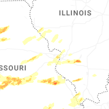
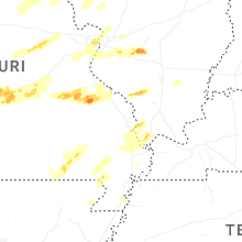
Missouri
| Local Time | Report Details |
|---|---|
| 5:07 PM CDT | Private weather senso in cass county MO, 27.9 miles S of Kansas City, MO |
| 5:07 PM CDT | Time estimated from rada in cass county MO, 33.9 miles S of Kansas City, MO |
| 5:26 PM CDT | Several reports of downed power poles or downed wires near the peculiar area. time estimated from rada in cass county MO, 26.2 miles SSE of Kansas City, MO |
| 5:27 PM CDT | Large tree down near second street. social media report and video. time confirmed from rada in bates county MO, 50.1 miles SSE of Kansas City, MO |
| 5:40 PM CDT | Ping Pong Ball sized hail reported near Rich Hill, MO, 59.5 miles ENE of Chanute, KS |
| 5:49 PM CDT | Hen Egg sized hail reported near Nevada, MO, 60.8 miles E of Chanute, KS, report from mping. hen egg (2.00 in.). |
| 5:50 PM CDT | Ping Pong Ball sized hail reported near Nevada, MO, 60.8 miles E of Chanute, KS, report from mping ping pong ball (1.50 in.). |
| 5:50 PM CDT | Golf Ball sized hail reported near Nevada, MO, 60.3 miles ENE of Chanute, KS |
| 5:50 PM CDT | Hen Egg sized hail reported near Nevada, MO, 61.4 miles E of Chanute, KS, several rvs with roof damage from hail. |
| 5:50 PM CDT | Social media report. large tree downed onto property in butler. time estimated from rada in bates county MO, 59.7 miles SSE of Kansas City, MO |
| 5:54 PM CDT | Downed wires and power outages near route zz. time estimated from rada in johnson county MO, 44.5 miles SE of Kansas City, MO |
| 6:00 PM CDT | Tree limbs down between creighton and urich. report relayed via social media. time estimated from rada in henry county MO, 52 miles SE of Kansas City, MO |
| 6:03 PM CDT | Tennis Ball sized hail reported near Walker, MO, 68.5 miles ENE of Chanute, KS, windshield shattered due to tennis ball size hail. |
| 6:12 PM CDT | Half Dollar sized hail reported near El Dorado Springs, MO, 61.2 miles NW of Springfield, MO, report from mping half dollar (1.25 in.). |
| 6:14 PM CDT | Hen Egg sized hail reported near El Dorado Springs, MO, 62.6 miles NW of Springfield, MO, west of el dorado springs. |
| 6:14 PM CDT | Several reports of downed wires and power outages near routes n and o. time estimated from rada in henry county MO, 58.4 miles SE of Kansas City, MO |
| 6:18 PM CDT | Golf Ball sized hail reported near El Dorado Springs, MO, 60.6 miles NW of Springfield, MO, reported at a hospital. |
| 6:20 PM CDT | Hen Egg sized hail reported near El Dorado Springs, MO, 60.6 miles NW of Springfield, MO |
| 6:20 PM CDT | Ping Pong Ball sized hail reported near El Dorado Springs, MO, 61.2 miles NW of Springfield, MO, report from mping ping pong ball (1.50 in.). |
| 6:20 PM CDT | Baseball sized hail reported near El Dorado Springs, MO, 61 miles NW of Springfield, MO |
| 6:22 PM CDT | Quarter sized hail reported near El Dorado Springs, MO, 61.2 miles NW of Springfield, MO, report from mping - quarter (1.00 in.). |
| 6:28 PM CDT | Quarter sized hail reported near Leeton, MO, 59.5 miles ESE of Kansas City, MO, report relayed from social media. time estimated from radar. |
| 6:29 PM CDT | Trees down near sparrowfoot campground. report relayed via social media. time estimated from rada in henry county MO, 71.7 miles SE of Kansas City, MO |
| 6:30 PM CDT | Tree downed onto a shed in clinton... mo. report relayed via social media. time estimated from rada in henry county MO, 67 miles SE of Kansas City, MO |
| 6:40 PM CDT | Baseball sized hail reported near Stockton, MO, 49.1 miles NNW of Springfield, MO |
| 6:58 PM CDT | Quarter sized hail reported near Golden City, MO, 45.7 miles WNW of Springfield, MO |
| 6:58 PM CDT | Damage to a brick building in collin in st. clair county MO, 50.5 miles NNW of Springfield, MO |
| 7:01 PM CDT | Baseball sized hail reported near Humansville, MO, 43.1 miles NNW of Springfield, MO |
| 7:01 PM CDT | Ping Pong Ball sized hail reported near Humansville, MO, 43.1 miles NNW of Springfield, MO |
| 7:01 PM CDT | Hen Egg sized hail reported near Humansville, MO, 43.1 miles NNW of Springfield, MO |
| 7:03 PM CDT | Quarter sized hail reported near Humansville, MO, 42.2 miles NNW of Springfield, MO |
| 7:17 PM CDT | Quarter sized hail reported near Sedalia, MO, 51.4 miles WSW of Columbia, MO, social media report. time estimated from radar. |
| 7:21 PM CDT | Hen Egg sized hail reported near Greenfield, MO, 33.5 miles WNW of Springfield, MO, near greenfield. |
| 7:25 PM CDT | Ping Pong Ball sized hail reported near Wheatland, MO, 45.7 miles N of Springfield, MO |
| 7:32 PM CDT | Quarter sized hail reported near Arcola, MO, 36.6 miles NW of Springfield, MO, dade county line on stockton lake. |
| 7:35 PM CDT | Hen Egg sized hail reported near Pittsburg, MO, 41.6 miles N of Springfield, MO, report from mping - hen egg (2.00 in.). |
| 7:42 PM CDT | Golf Ball sized hail reported near Greenfield, MO, 38.8 miles NW of Springfield, MO |
| 7:43 PM CDT | Golf Ball sized hail reported near Greenfield, MO, 35.6 miles WNW of Springfield, MO |
| 8:07 PM CDT | Golf Ball sized hail reported near Walnut Grove, MO, 19.9 miles NW of Springfield, MO |
| 8:17 PM CDT | Golf Ball sized hail reported near Morrisville, MO, 20.2 miles NNW of Springfield, MO |
| 9:52 PM CDT | Several reports of downed wires and power outages in the archie area. time estimated from rada in cass county MO, 43.6 miles SSE of Kansas City, MO |
| 10:22 PM CDT | Ping Pong Ball sized hail reported near Garden City, MO, 46.7 miles SSE of Kansas City, MO, social media report. time estimated from radar. |
| 10:25 PM CDT | Hen Egg sized hail reported near Garden City, MO, 46.6 miles SSE of Kansas City, MO, social media video. time estimated from radar. |
| 10:25 PM CDT | Half Dollar sized hail reported near Lebanon, MO, 45.3 miles NE of Springfield, MO |
| 10:35 PM CDT | Ping Pong Ball sized hail reported near Creighton, MO, 48.8 miles SSE of Kansas City, MO, social media report. time estimated from radar. |
| 10:39 PM CDT | Tennis Ball sized hail reported near Creighton, MO, 50 miles SSE of Kansas City, MO, social media report and photo. |
| 11:08 PM CDT | Tree was downe in newton county MO, 58.6 miles WSW of Springfield, MO |
| 2:56 AM CDT | Half Dollar sized hail reported near Rolla, MO, 25.7 miles NNW of Salem, MO |
| 2:57 AM CDT | Golf Ball sized hail reported near Caledonia, MO, 42.8 miles ENE of Salem, MO |
| 2:58 AM CDT | Quarter sized hail reported near Rolla, MO, 24.3 miles NNW of Salem, MO |
| 3:00 AM CDT | Quarter sized hail reported near Rolla, MO, 23.6 miles NNW of Salem, MO |
| 3:07 AM CDT | Hen Egg sized hail reported near Irondale, MO, 49.4 miles ENE of Salem, MO, time estimated from radar. |
| 3:08 AM CDT | Half Dollar sized hail reported near Irondale, MO, 49.4 miles ENE of Salem, MO |
| 3:33 AM CDT | Hen Egg sized hail reported near Farmington, MO, 58.3 miles NW of Cape Girardeau, MO, photo of multiple large hail stones... largest is measured at 2 inches. time estimated from radar. |
| 3:33 AM CDT | Golf Ball sized hail reported near Farmington, MO, 59.2 miles NW of Cape Girardeau, MO, time estimated from radar. |
| 3:33 AM CDT | Hen Egg sized hail reported near Farmington, MO, 58.8 miles WNW of Cape Girardeau, MO, time estimated from radar. |
| 3:33 AM CDT | Hen Egg sized hail reported near Farmington, MO, 58.7 miles NW of Cape Girardeau, MO, time estimated from radar. |
| 3:33 AM CDT | Quarter sized hail reported near Dearborn, MO, 30.5 miles NNW of Kansas City, MO, time estimated from radar. |
| 3:36 AM CDT | Golf Ball sized hail reported near Farmington, MO, 55.8 miles NW of Cape Girardeau, MO |
| 3:41 AM CDT | Quarter sized hail reported near Camden Point, MO, 26.5 miles N of Kansas City, MO, report from mping: quarter (1.00 in.). |
| 3:54 AM CDT | Time estimated from rada in platte county MO, 10.4 miles NNW of Kansas City, MO |
| 4:09 AM CDT | Semi blown over. tree blown down. time estimated from rada in clinton county MO, 43.2 miles NNE of Kansas City, MO |
| 4:10 AM CDT | Trees across u.s. 69 south of highway 121. time estimated from rada in clinton county MO, 42.6 miles NNE of Kansas City, MO |
| 4:13 AM CDT | Shingles blown off house and minor property damage. time and location estimate in clinton county MO, 43.3 miles NNE of Kansas City, MO |
| 4:23 AM CDT | Trees down on route 13 south of kingston. time estimated from rada in caldwell county MO, 47.1 miles NE of Kansas City, MO |
| 4:33 AM CDT | Private weather senso in clay county MO, 11.6 miles N of Kansas City, MO |
| 5:28 AM CDT | Quarter sized hail reported near Williamsville, MO, 61.3 miles WSW of Cape Girardeau, MO |
| 6:16 AM CDT | Ping Pong Ball sized hail reported near Saint Louis, MO, 7.6 miles WNW of Saint Louis, MO, estimated ping pong sized hail with photo and us quarter. time estimated from radar. |
| 6:20 AM CDT | Quarter sized hail reported near Saint Louis, MO, 5.4 miles W of Saint Louis, MO |
| 6:46 AM CDT | Quarter sized hail reported near Cape Girardeau, MO, 0.6 miles NNW of Cape Girardeau, MO, quarter size hail report four blocks east of the university. |
Texas
| Local Time | Report Details |
|---|---|
| 5:08 PM CDT | Quarter sized hail reported near Iowa Park, TX, 11.9 miles WNW of Wichita Falls, TX |
| 5:11 PM CDT | Ping Pong Ball sized hail reported near Iowa Park, TX, 10.9 miles WNW of Wichita Falls, TX |
| 5:11 PM CDT | Golf Ball sized hail reported near Iowa Park, TX, 11.9 miles WNW of Wichita Falls, TX |
| 5:19 PM CDT | Tea Cup sized hail reported near Iowa Park, TX, 11.9 miles WNW of Wichita Falls, TX |
| 5:35 PM CDT | Quarter sized hail reported near Iowa Park, TX, 7.5 miles NW of Wichita Falls, TX, report from mping: quarter (1.00 in.). |
| 5:46 PM CDT | Golf Ball sized hail reported near Wichita Falls, TX, 5.2 miles NNW of Wichita Falls, TX |
| 5:46 PM CDT | Quarter sized hail reported near Wichita Falls, TX, 5.1 miles NNW of Wichita Falls, TX, report from mping: quarter (1.00 in.). |
| 6:00 PM CDT | Golf Ball sized hail reported near Burkburnett, TX, 12.5 miles NNW of Wichita Falls, TX, photo of large hail on the south side of burkburnett. |
| 6:08 PM CDT | Quarter sized hail reported near Burkburnett, TX, 11.6 miles NNW of Wichita Falls, TX, report from mping: quarter (1.00 in.). |
| 7:11 PM CDT | Hen Egg sized hail reported near Wichita Falls, TX, 11.2 miles NE of Wichita Falls, TX, report from mping: hen egg+ (2.25 in.). |
| 7:15 PM CDT | Golf Ball sized hail reported near Wichita Falls, TX, 11.2 miles NE of Wichita Falls, TX, report from mping: golf ball (1.75 in.). |
| 7:52 PM CDT | Quarter sized hail reported near Byers, TX, 21.4 miles ENE of Wichita Falls, TX, report from mping: quarter (1.00 in.). |
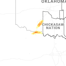
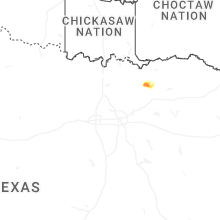
Oklahoma
| Local Time | Report Details |
|---|---|
| 5:53 PM CDT | Quarter sized hail reported near Walters, OK, 33.6 miles N of Wichita Falls, TX |
| 6:02 PM CDT | Quarter sized hail reported near Devol, OK, 19.3 miles NNW of Wichita Falls, TX, report from mping: quarter (1.00 in.). |
| 6:13 PM CDT | Golf Ball sized hail reported near Lawton, OK, 49.9 miles NNE of Wichita Falls, TX |
| 6:14 PM CDT | Quarter sized hail reported near Lawton, OK, 48 miles NNE of Wichita Falls, TX, report from mping: quarter (1.00 in.). |
| 6:16 PM CDT | Baseball sized hail reported near Lawton, OK, 50.4 miles NNE of Wichita Falls, TX |
| 6:26 PM CDT | Baseball sized hail reported near Lawton, OK, 55.2 miles NNE of Wichita Falls, TX |
| 6:46 PM CDT | Quarter sized hail reported near Rush Springs, OK, 53.8 miles SSW of Oklahoma City, OK, report from mping: quarter (1.00 in.). |
| 7:30 PM CDT | Quarter sized hail reported near Shidler, OK, 58 miles NNW of Tulsa, OK |
Colorado
| Local Time | Report Details |
|---|---|
| 6:55 PM MDT | Quarter sized hail reported near Vona, CO, 71.7 miles S of Yuma, CO, spotter network report of hail up to quarter in size. |
| 7:27 PM MDT | Ping Pong Ball sized hail reported near Bethune, CO, 63.9 miles SSE of Yuma, CO, hail ranging from pea to 1.5 inches due south of bethune between county roads n and p on cr 40. |
Illinois
| Local Time | Report Details |
|---|---|
| 5:39 AM CDT | Golf Ball sized hail reported near Vergennes, IL, 42.7 miles NNE of Cape Girardeau, MO |
| 5:41 AM CDT | Quarter sized hail reported near Belleville, IL, 13.9 miles SE of Saint Louis, MO, pea to quarter sized hail. time estimate from radar. |
| 5:41 AM CDT | Half Dollar sized hail reported near Vergennes, IL, 42.7 miles NNE of Cape Girardeau, MO |
| 5:51 AM CDT | Golf Ball sized hail reported near Dowell, IL, 47 miles NNE of Cape Girardeau, MO |
Connect with Interactive Hail Maps