

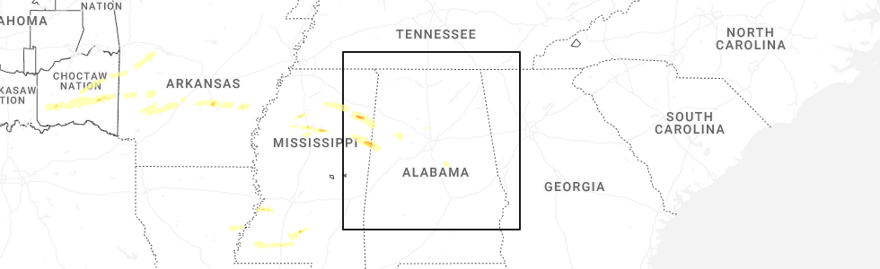
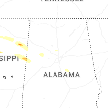
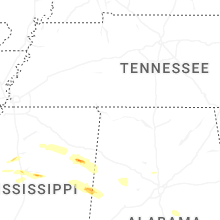
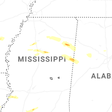
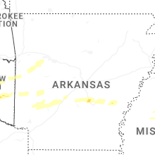
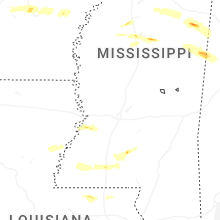
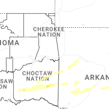
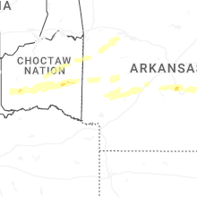
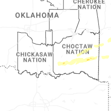
Hail Map for Monday, March 9, 2026
Number of Impacted Households on 3/9/2026
0
Impacted by 1" or Larger Hail
0
Impacted by 1.75" or Larger Hail
0
Impacted by 2.5" or Larger Hail
Square Miles of Populated Area Impacted on 3/9/2026
0
Impacted by 1" or Larger Hail
0
Impacted by 1.75" or Larger Hail
0
Impacted by 2.5" or Larger Hail
Cities Most Affected by Hail Storms of 3/9/2026
| Hail Size | Demographics of Zip Codes Affected | ||||||
|---|---|---|---|---|---|---|---|
| City | Count | Average | Largest | Pop Density | House Value | Income | Age |
Hail and Wind Damage Spotted on 3/9/2026
Filter by Report Type:Hail ReportsWind Reports
Arkansas
| Local Time | Report Details |
|---|---|
| 12:20 PM CDT | Quarter sized hail reported near White Hall, AR, 33.8 miles SSE of Little Rock, AR, at least quarter size hail reported near white hall. |
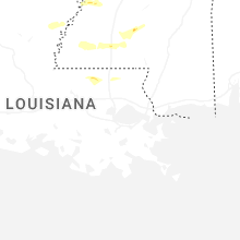
Louisiana
| Local Time | Report Details |
|---|---|
| 2:25 PM CDT | Multiple trees were downed across northern catahoula parish... some blocking roads including at the la hwy 124 and tew lake rd intersectio in catahoula county LA, 74.5 miles S of Bastrop, LA |
| 6:30 PM CDT | Quarter sized hail reported near Clinton, LA, 77.1 miles NW of New Orleans, LA, broadcast media submitted viewer photo of quarter sized hail on hatcher road east of clinton. time estimated by radar. |
Tennessee
| Local Time | Report Details |
|---|---|
| 3:13 PM CDT | Tree blocking roadway south of pocahonta in hardeman county TN, 66 miles WNW of Florence, AL |
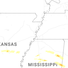
Mississippi
| Local Time | Report Details |
|---|---|
| 4:00 PM CDT | Trees down near commerce dr and hwy in lafayette county MS, 65.2 miles SSE of Memphis, TN |
| 4:15 PM CDT | Tree down on liberty roa in franklin county MS, 83 miles SW of Jackson, MS |
| 4:32 PM CDT | Half Dollar sized hail reported near Meadville, MS, 71.1 miles SW of Jackson, MS, hail up to half dollar size in meadville. |
| 4:42 PM CDT | Several power poles snappe in pontotoc county MS, 61.2 miles NNW of Starkville, MS |
| 5:04 PM CDT | Quarter sized hail reported near Grenada, MS, 64 miles WNW of Starkville, MS |
| 5:43 PM CDT | Quarter sized hail reported near Summit, MS, 65.9 miles SSW of Jackson, MS |
| 5:55 PM CDT | Quarter sized hail reported near Nettleton, MS, 40.3 miles NNE of Starkville, MS, motorist reports having to pull off the highway near central grove road due to quarter sized hail falling. |
| 5:57 PM CDT | Quarter sized hail reported near Aberdeen, MS, 36.5 miles NNE of Starkville, MS |
| 6:00 PM CDT | Quarter sized hail reported near Amory, MS, 40.9 miles NNE of Starkville, MS |
| 6:03 PM CDT | Report of a tree down on old highway 6. time estimated from rada in monroe county MS, 42.4 miles NNE of Starkville, MS |
| 7:33 PM CDT | Multiple trees were downed around west poin in clay county MS, 13.7 miles NE of Starkville, MS |
| 8:06 PM CDT | Trees on homes at 121 and 126 gaylane driv in lowndes county MS, 25.7 miles E of Starkville, MS |
| 8:07 PM CDT | Quarter sized hail reported near Columbus, MS, 22.8 miles E of Starkville, MS, pictures from 0.6 miles north of main street in columbus showed hail the size of quarters. |
| 8:07 PM CDT | A tree fell onto a home in the 800 block of alabama street and in the 200 block of taylor street. scattered power lines were also downed... including a transformer down in lowndes county MS, 24 miles E of Starkville, MS |
| 8:15 PM CDT | Ping Pong Ball sized hail reported near Oakland, MS, 75.3 miles WNW of Starkville, MS |
| 8:15 PM CDT | Quarter sized hail reported near Columbus, MS, 29.1 miles E of Starkville, MS, nickel to quarter size hail was beginning to accumulate near mt. vernon church. |
Alabama
| Local Time | Report Details |
|---|---|
| 5:12 PM CDT | Lots of trees/power lines were reported down along highway 34 between phil campbell and russellvill in franklin county AL, 27 miles S of Florence, AL |
| 5:14 PM CDT | Lots of trees and power lines were reported down along highway 38 between phil campbell and russellvill in franklin county AL, 25.8 miles S of Florence, AL |
| 5:32 PM CDT | Damage involving trees and structure in winston county AL, 36.6 miles SSE of Florence, AL |
| 5:49 PM CDT | A tree and some powerlines were reported down near the intersection of alabama highway 33 and cr in lawrence county AL, 38.6 miles SSE of Florence, AL |
| 6:35 PM CDT | Damage to the canopy of a gas station was reported at 7810 al highway 6 in cullman county AL, 50.9 miles N of Birmingham, AL |
| 6:50 PM CDT | Reports of gusty winds and a few tree down reports in blount county. altoona... blountsville... brooksvill in blount county AL, 49.5 miles NNE of Birmingham, AL |
| 7:05 PM CDT | An 18-wheeler/semi/big rig was flipped on highway 13 near the tuscaloosa county lin in tuscaloosa county AL, 49.1 miles W of Birmingham, AL |
| 7:10 PM CDT | Trees down in the hoover are in jefferson county AL, 8.3 miles S of Birmingham, AL |
| 7:26 PM CDT | Trees and powerlines downe in jefferson county AL, 15.1 miles N of Birmingham, AL |
| 7:40 PM CDT | Trees down in the leesburg are in cherokee county AL, 65.2 miles SSW of Chattanooga, TN |
| 7:40 PM CDT | Heavy tree fall on betty hill road. fd conducting search operations and are having to cut their way throug in jefferson county AL, 26.1 miles WSW of Birmingham, AL |
| 7:43 PM CDT | Trees downed in the blanche are in cherokee county AL, 50.3 miles SSW of Chattanooga, TN |
| 7:46 PM CDT | Trees downed on the north side of weiss lak in cherokee county AL, 56.4 miles SSW of Chattanooga, TN |
| 7:46 PM CDT | Trees down in the gaylesville are in cherokee county AL, 55.4 miles SSW of Chattanooga, TN |
| 7:46 PM CDT | Trees down in the area of mud creek road and groundhog roa in jefferson county AL, 21.8 miles WSW of Birmingham, AL |
| 7:50 PM CDT | Roof blown off chicken house in cherokee county AL, 54.3 miles SSW of Chattanooga, TN |
| 7:57 PM CDT | Large oak tree downed... taking out a fenc in jefferson county AL, 13 miles WSW of Birmingham, AL |
| 7:58 PM CDT | Trees down in the bessemer area... some involving power line in jefferson county AL, 11.9 miles SW of Birmingham, AL |
| 8:06 PM CDT | Trees down on shades crest roa in jefferson county AL, 9.3 miles SSW of Birmingham, AL |
| 8:10 PM CDT | Corrects previous tstm wnd dmg report from hoover for time. trees down in the hoover are in jefferson county AL, 8.3 miles S of Birmingham, AL |
| 8:11 PM CDT | Trees down in the vestavia hills are in jefferson county AL, 5.7 miles SSE of Birmingham, AL |
| 8:12 PM CDT | Trees down in the homewood are in jefferson county AL, 3.5 miles S of Birmingham, AL |
| 8:12 PM CDT | Reports of trees down and halls chapel road blocked off. time estimated from rada in calhoun county AL, 56.4 miles ENE of Birmingham, AL |
| 9:02 PM CDT | Reports of power lines down. time estimated from rada in talladega county AL, 39.7 miles ESE of Birmingham, AL |
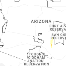
Arizona
| Local Time | Report Details |
|---|---|
| 5:55 PM MST | Wind damage to a portico attached to a mobile home at an rv park near u.s. 60 and goldfield road. nearby observing stations reported wind gusts 30 to 40 mph at the time in pinal county AZ, 33 miles E of Phoenix, AZ |
Georgia
| Local Time | Report Details |
|---|---|
| 12:20 AM EDT | Tree down near the intersection of jordan dr and oneal d in harris county GA, 43.6 miles E of Auburn, AL |
Connect with Interactive Hail Maps