

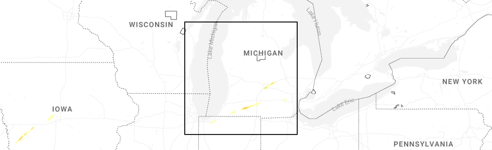
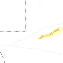
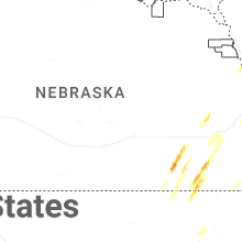
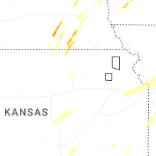
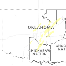
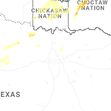
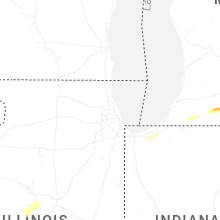
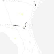
Hail Map for Friday, March 6, 2026
Number of Impacted Households on 3/6/2026
0
Impacted by 1" or Larger Hail
0
Impacted by 1.75" or Larger Hail
0
Impacted by 2.5" or Larger Hail
Square Miles of Populated Area Impacted on 3/6/2026
0
Impacted by 1" or Larger Hail
0
Impacted by 1.75" or Larger Hail
0
Impacted by 2.5" or Larger Hail
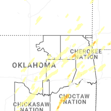
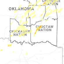

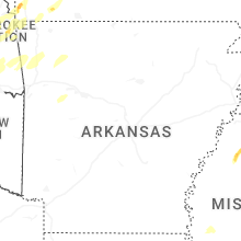
Cities Most Affected by Hail Storms of 3/6/2026
| Hail Size | Demographics of Zip Codes Affected | ||||||
|---|---|---|---|---|---|---|---|
| City | Count | Average | Largest | Pop Density | House Value | Income | Age |
| Bruning, NE | 4 | 2.06 | 2.50 | 4 | $46k | $33.6k | 47.1 |
| Ohiowa, NE | 2 | 1.88 | 2.00 | 3 | $28k | $26.3k | 44.0 |
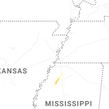
| Batesville, MS | 1 | 1.75 | 1.75 | 57 | $65k | $29.4k | 35.3 |
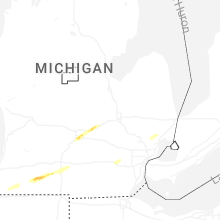
| Mendon, MI | 1 | 1.75 | 1.75 | 52 | $85k | $41.8k | 41.0 |
| Clatonia, NE | 1 | 1.75 | 1.75 | 9 | $49k | $38.8k | 46.8 |
| Westville, IN | 1 | 1.75 | 1.75 | 143 | $128k | $46.9k | 35.2 |
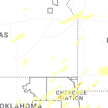
Hail and Wind Damage Spotted on 3/6/2026
Filter by Report Type:Hail ReportsWind Reports
States Impacted
Indiana, Michigan, Alabama, Georgia, Illinois, Nebraska, Oklahoma, Florida, Iowa, Missouri, Kansas, MississippiIndiana
| Local Time | Report Details |
|---|---|
| 12:57 PM CST | Golf Ball sized hail reported near Westville, IN, 44 miles ESE of Chicago, IL, location and time estimated by radar. public commenter listed westville. |
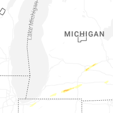
Michigan
| Local Time | Report Details |
|---|---|
| 3:20 PM EST | Quarter sized hail reported near Cassopolis, MI, 74.5 miles NW of Fort Wayne, IN, video shows hail up to a quarter in size in cassopolis... time estimated via radar. |
| 3:49 PM EST | Quarter sized hail reported near Three Rivers, MI, 65.7 miles NNW of Fort Wayne, IN, photo of hail up to a quarter in diameter in a photo taken on marcellus rd in three rivers. time estimated via radar. |
| 3:51 PM EST | Golf Ball sized hail reported near Mendon, MI, 66.7 miles NNW of Fort Wayne, IN, photo on facebook shows a hailstone measured to be 1.75 inches. public reports it fell between mendon and three rivers. time estimated via radar. |
| 3:52 PM EST | Ping Pong Ball sized hail reported near Mendon, MI, 66.9 miles S of Grand Rapids, MI, hail estimated to be between 1 to 1.5 inches in diameter seen in a photo on facebook from mendon... mi. time estimated via radar. |
| 4:27 PM EST | Half Dollar sized hail reported near Athens, MI, 65.2 miles SSE of Grand Rapids, MI |
| 4:54 PM EST | Torn down exit sig in calhoun county MI, 68.3 miles SSE of Grand Rapids, MI |
| 7:13 PM EST | Quarter sized hail reported near Lansing, MI, 48 miles WSW of Flint, MI |
| 7:17 PM EST | Quarter sized hail reported near Lansing, MI, 47.8 miles WSW of Flint, MI, report from mping: quarter (1.00 in.). |
| 7:19 PM EST | Quarter sized hail reported near Lansing, MI, 48.4 miles WSW of Flint, MI |
| 7:27 PM EST | Quarter sized hail reported near East Lansing, MI, 44 miles WSW of Flint, MI |
| 9:39 PM EST | Quarter sized hail reported near Utica, MI, 41.4 miles ESE of Flint, MI, hail reported near hayes and 26 mile road. |
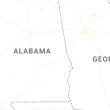
Alabama
| Local Time | Report Details |
|---|---|
| 2:45 PM CST | 911 call center reported a tree down along cr 36 in eastern geneva county. time estimated by rada in geneva county AL, 64.3 miles NE of Miramar Beach, FL |
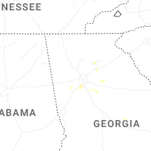
Georgia
| Local Time | Report Details |
|---|---|
| 4:51 PM EST | Quarter sized hail reported near Camilla, GA, 54.8 miles N of Tallahassee, FL, trained storm spotter reported quarter sized hail near camilla... ga. |
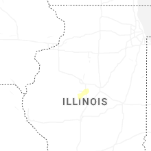
Illinois
| Local Time | Report Details |
|---|---|
| 4:10 PM CST | Large branch blown down across street. time estimated from rada in tazewell county IL, 15.9 miles SE of Peoria, IL |
| 4:20 PM CST | Semi truck blown over. time estimated from rada in mclean county IL, 25.3 miles ESE of Peoria, IL |
| 4:20 PM CST | Grain bin... tree... small sheds... playground set... garage door... and soffit damage. time estimated from rada in mclean county IL, 24.3 miles ESE of Peoria, IL |
| 4:26 PM CST | Tree branch reportedly fell onto a car on rose street. wind gust of 58 mph provided as wel in cook county IL, 23.8 miles S of Chicago, IL |
| 11:42 PM CST | Delayed report. power pole snapped and tree blown over. time estimated from rada in fulton county IL, 40 miles WSW of Peoria, IL |
| 3:30 AM CST | Numerous tree limbs and power lines down in salem. at least one large tree down/uprooted. damage to at least one home caused by falling branches and/or downed tree. tim in marion county IL, 66.4 miles SSW of Mattoon, IL |
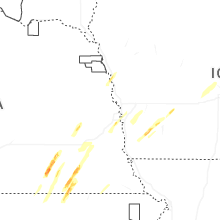
Nebraska
| Local Time | Report Details |
|---|---|
| 4:43 PM CST | Quarter sized hail reported near Hubbell, NE, 76.1 miles NW of Manhattan, KS, nickel to quarter size hail. most was smaller and did not last long. |
| 6:07 PM CST | Quarter sized hail reported near Hebron, NE, 62.6 miles SE of Grand Island, NE |
| 6:12 PM CST | Ping Pong Ball sized hail reported near Belvidere, NE, 62.1 miles SE of Grand Island, NE, updated hail size from previous location. found a few hailstones up to 1.5 inch diameter. |
| 6:15 PM CST | Hen Egg sized hail reported near Bruning, NE, 59.5 miles SE of Grand Island, NE, picture from facebook. |
| 6:20 PM CST | Golf Ball sized hail reported near Bruning, NE, 57.5 miles SE of Grand Island, NE |
| 6:20 PM CST | Hen Egg sized hail reported near Bruning, NE, 57.1 miles SE of Grand Island, NE |
| 6:21 PM CST | Tennis Ball sized hail reported near Bruning, NE, 57.1 miles SE of Grand Island, NE |
| 6:29 PM CST | Golf Ball sized hail reported near Ohiowa, NE, 57.5 miles SE of Grand Island, NE |
| 6:33 PM CST | Hen Egg sized hail reported near Ohiowa, NE, 55.5 miles ESE of Grand Island, NE |
| 7:00 PM CST | Quarter sized hail reported near Plymouth, NE, 80.6 miles NNW of Manhattan, KS |
| 7:03 PM CST | Quarter sized hail reported near Plymouth, NE, 80.6 miles NNW of Manhattan, KS, image shared via social media. delayed report... time estimated from radar. |
| 7:05 PM CST | Ping Pong Ball sized hail reported near Steele City, NE, 64.2 miles NNW of Manhattan, KS, photo of several 1.25 to 1.5 inch diameter stones. |
| 7:09 PM CST | Half Dollar sized hail reported near Diller, NE, 69.7 miles NNW of Manhattan, KS |
| 7:15 PM CST | Golf Ball sized hail reported near Clatonia, NE, 73.8 miles SW of Omaha, NE |
| 7:19 PM CST | Quarter sized hail reported near Schuyler, NE, 59.8 miles WNW of Omaha, NE, report from mping. |
| 7:22 PM CST | Quarter sized hail reported near Valparaiso, NE, 49.9 miles WSW of Omaha, NE, delayed report... time estimated with radar. image shared via social media. |
| 7:30 PM CST | Quarter sized hail reported near Seward, NE, 64.9 miles E of Grand Island, NE |
| 8:31 PM CST | Quarter sized hail reported near Tekamah, NE, 38.7 miles NNW of Omaha, NE |
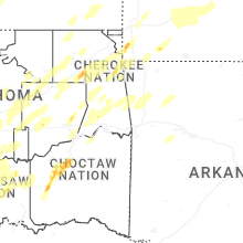
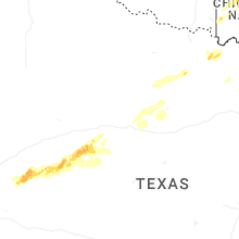
Oklahoma
| Local Time | Report Details |
|---|---|
| 4:46 PM CST | Quarter sized hail reported near Stroud, OK, 46.4 miles SW of Tulsa, OK |
| 6:24 PM CST | Quarter sized hail reported near Tulsa, OK, 8.4 miles NW of Tulsa, OK, report from mping: quarter (1.00 in.). |
| 8:14 PM CST | Quarter sized hail reported near Bixby, OK, 13.3 miles S of Tulsa, OK, report from mping: quarter (1.00 in.). |
| 8:40 PM CST | Measured 66 mph wind gust at vinita mesone in craig county OK, 61.7 miles NE of Tulsa, OK |
| 8:58 PM CST | Several storm trackers reported gusts of 80-90 mph on south side of pryo in mayes county OK, 37.2 miles E of Tulsa, OK |
| 9:20 PM CST | Half Dollar sized hail reported near Atoka, OK, 0.8 miles WSW of Atoka, OK |
| 12:46 AM CST | Quarter sized hail reported near Waurika, OK, 33.9 miles ENE of Wichita Falls, TX |
| 12:55 AM CST | Quarter sized hail reported near Oklahoma City, OK, 0.6 miles ESE of Oklahoma City, OK, corrects time from the previous report. relayed via spotter network. |
| 2:55 AM CST | Oklahoma mesone in carter county OK, 65.3 miles W of Atoka, OK |
| 3:05 AM CST | Ardmore mesone in carter county OK, 55.4 miles WSW of Atoka, OK |
Florida
| Local Time | Report Details |
|---|---|
| 5:52 PM EST | Duke energy reported a power outage caused by fallen tree limbs at 5:52pm es in madison county FL, 51.4 miles E of Tallahassee, FL |
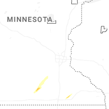
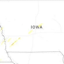
Iowa
| Local Time | Report Details |
|---|---|
| 6:05 PM CST | Quarter sized hail reported near Emerson, IA, 34.3 miles ESE of Omaha, NE, report from mping. |
| 6:11 PM CST | Quarter sized hail reported near Elliott, IA, 41.4 miles E of Omaha, NE, report from mping. |
| 6:12 PM CST | Half Dollar sized hail reported near Elliott, IA, 41.4 miles E of Omaha, NE, report from mping. |
| 8:40 PM CST | Ping Pong Ball sized hail reported near Blencoe, IA, 46.9 miles N of Omaha, NE |
| 8:43 PM CST | Quarter sized hail reported near Blencoe, IA, 46.8 miles N of Omaha, NE |
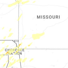
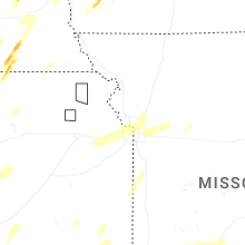
Missouri
| Local Time | Report Details |
|---|---|
| 6:37 PM CST | Quarter sized hail reported near Carthage, MO, 54 miles W of Springfield, MO |
| 7:48 PM CST | Em reports wind damage on south street between 4th and main in booneville. reports came in between 730p-815p. radar shows a storm directly over this location around 748 in cooper county MO, 21.9 miles W of Columbia, MO |
| 8:18 PM CST | *** 1 inj *** semi turned over... injury acciden in barton county MO, 60 miles WNW of Springfield, MO |
| 8:18 PM CST | Mesonet station moa06 lama in barton county MO, 59.3 miles WNW of Springfield, MO |
| 8:30 PM CST | Tree down and power pole down 300 out of powe in barton county MO, 58 miles WNW of Springfield, MO |
| 9:03 PM CST | Power pole dow in polk county MO, 43.7 miles NNW of Springfield, MO |
| 10:15 PM CST | Em reported 78 mph wind gust 7 mi wsw of goodman... m in mcdonald county MO, 76.2 miles WSW of Springfield, MO |
| 10:18 PM CST | Tree down at highway u and bentown ridge roa in miller county MO, 60.1 miles S of Columbia, MO |
| 10:19 PM CST | Em reported 81 mph wind gust 7 mi wsw of goodman... m in mcdonald county MO, 76.2 miles WSW of Springfield, MO |
| 10:20 PM CST | 2 trees down and powerline dow in benton county MO, 66.2 miles SW of Columbia, MO |
| 10:30 PM CST | Quarter sized hail reported near Goodman, MO, 70.9 miles WSW of Springfield, MO, report from mping: quarter (1.00 in.). |
| 10:30 PM CST | Tree reported down on roadwa in boone county MO, 8.5 miles S of Columbia, MO |
| 10:35 PM CST | Report of a tree down on the roadwa in boone county MO, 5.7 miles S of Columbia, MO |
| 10:35 PM CST | Report of a 10 inch diameter tree over the roadwa in boone county MO, 3.8 miles SSE of Columbia, MO |
| 10:39 PM CST | Bradford farm missouri mesonet weather station measured wind gus in boone county MO, 7.1 miles ESE of Columbia, MO |
| 10:40 PM CST | Report of electric pole down on the roadwa in boone county MO, 2.2 miles NE of Columbia, MO |
| 11:45 PM CST | Estimated 60 mph wind gusts in west plaz in jackson county MO, 4.4 miles SSW of Kansas City, MO |
| 12:32 AM CST | Quarter sized hail reported near Cassville, MO, 48.5 miles SW of Springfield, MO, report relayed via broadcast media livestream. |
| 2:06 AM CST | Em reports roof damage to older commercial building in booneville... first reported around 230am. radar indicates a decaying storm may have produced a downburst around in cooper county MO, 22.5 miles W of Columbia, MO |
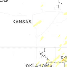
Kansas
| Local Time | Report Details |
|---|---|
| 7:28 PM CST | Quarter sized hail reported near Douglass, KS, 20.2 miles ESE of Wichita, KS |
| 7:50 PM CST | *** 1 inj *** side of house blown in...1 injur in cherokee county KS, 48.8 miles SE of Chanute, KS |
| 11:38 PM CST | Power flashes in merria in johnson county KS, 7.2 miles SW of Kansas City, MO |
| 11:39 PM CST | Reports of trees and power lines down. time estimated from rada in johnson county KS, 8.1 miles SW of Kansas City, MO |
| 11:43 PM CST | Pictures of downed trees on social media near and south of 39th st. time estimated from rada in jackson county MO, 3.3 miles SSW of Kansas City, MO |
Mississippi
| Local Time | Report Details |
|---|---|
| 10:22 PM CST | Golf Ball sized hail reported near Batesville, MS, 52.4 miles S of Memphis, TN |
| 10:46 PM CST | Ping Pong Ball sized hail reported near Senatobia, MS, 37.9 miles S of Memphis, TN, reported ping pong sized hail in new town... ms. |
Connect with Interactive Hail Maps