

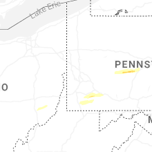
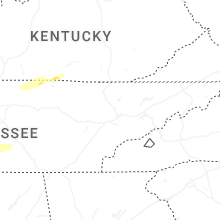
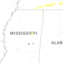
Hail Map for Wednesday, March 11, 2026

Number of Impacted Households on 3/11/2026
0
Impacted by 1" or Larger Hail
0
Impacted by 1.75" or Larger Hail
0
Impacted by 2.5" or Larger Hail
Square Miles of Populated Area Impacted on 3/11/2026
0
Impacted by 1" or Larger Hail
0
Impacted by 1.75" or Larger Hail
0
Impacted by 2.5" or Larger Hail

Cities Most Affected by Hail Storms of 3/11/2026
| Hail Size | Demographics of Zip Codes Affected | ||||||
|---|---|---|---|---|---|---|---|
| City | Count | Average | Largest | Pop Density | House Value | Income | Age |
Hail and Wind Damage Spotted on 3/11/2026
Filter by Report Type:Hail ReportsWind Reports
States Impacted
Indiana, Arkansas, Ohio, Alabama, Pennsylvania, Illinois, Tennessee, Texas, Kentucky, Virginia, Louisiana, Maryland, Mississippi, Delaware, New Jersey, Georgia, FloridaIndiana
| Local Time | Report Details |
|---|---|
| 8:00 AM EDT | Corrects previous tstm wnd dmg report from 1 sse lizton. tree down on sr 136 near entrance to tri west middle school. long section of chain link fence torn off its supp in hendricks county IN, 22.2 miles WNW of Indianapolis, IN |
| 8:07 AM EDT | Corrects previous tstm wnd dmg report from linton. thunderstorm wind damage to a roof and billboar in greene county IN, 72 miles ESE of Mattoon, IL |
| 8:17 AM EDT | Thunderstorm winds blew down tree in putnam county IN, 38.6 miles WSW of Indianapolis, IN |
| 8:19 AM EDT | Storm damage reported in boone county IN, 15.4 miles NNW of Indianapolis, IN |
| 8:25 AM EDT | Power lines down. time estimated from rada in marion county IN, 8.5 miles N of Indianapolis, IN |
| 8:27 AM EDT | Trees down along allisonville from 71st to 75th. time estimated from rada in marion county IN, 9.1 miles NNE of Indianapolis, IN |
| 8:28 AM EDT | Garage door blown in. time estimated from rada in marion county IN, 7.8 miles N of Indianapolis, IN |
| 8:32 AM EDT | Southbound lanes of sr 37 blocked by a large tree limb at promise roa in hamilton county IN, 23.6 miles NNE of Indianapolis, IN |
| 8:34 AM EDT | Corrects previous tstm wnd dmg report from koleen. thunderstorm wind damage to a tre in greene county IN, 65.9 miles SSW of Indianapolis, IN |
| 8:39 AM EDT | Large tree toppled onto hous in marion county IN, 11.8 miles NE of Indianapolis, IN |
| 8:45 AM EDT | Some tree limbs dow in monroe county IN, 46 miles SSW of Indianapolis, IN |
| 8:48 AM EDT | Several trees and poles down blocking roads south of anderson near pendleton. structural damage to roofs of houses. time estimated by rada in madison county IN, 26.7 miles NE of Indianapolis, IN |
| 8:49 AM EDT | Many reports of large limbs dow in madison county IN, 31.7 miles NE of Indianapolis, IN |
| 8:50 AM EDT | Storm damage reported in madison county IN, 37 miles NE of Indianapolis, IN |
| 8:55 AM EDT | Delayed report. time estimated from radar. considerable lightly scattered debris from an old barn and possibly a shed in a yard and agricultural field between 900 w and in delaware county IN, 42.3 miles NE of Indianapolis, IN |
| 8:55 AM EDT | Delayed report. time estimated from radar. thunderstorm winds caused tree damage and roof damage to pole barn in and across from 1460 s 900 w daleville indian in delaware county IN, 39.7 miles NE of Indianapolis, IN |
| 8:58 AM EDT | Multiple trees and power lines down. damage to a pole bar in delaware county IN, 42.3 miles NE of Indianapolis, IN |
| 8:59 AM EDT | Power pole broken across the roadwa in pike county IN, 35.9 miles NNE of Evansville, IN |
| 9:00 AM EDT | Storm damage reported in delaware county IN, 45.1 miles NE of Indianapolis, IN |
| 9:05 AM EDT | Delayed report. a semi was flipped on its side by thunderstorm winds on i-65 at mile marker 83.5. time estimated from rada in johnson county IN, 26.6 miles SSE of Indianapolis, IN |
| 9:16 AM EDT | Multiple trees down - blocking roadway - power lines involve in ripley county IN, 43.6 miles WNW of Cincinnati, OH |
| 9:18 AM EDT | Damage to the roof of a barn but siding remains intact. roofing appears to be a combination of metal panels and wood 2x4s. time estimated by rada in jay county IN, 51.4 miles S of Fort Wayne, IN |
| 9:19 AM EDT | 1 foot diameter tree down... blocking roadway... power lines involve in ripley county IN, 40.7 miles WNW of Cincinnati, OH |
| 9:27 AM EDT | Power pole broke in rush county IN, 36.9 miles ESE of Indianapolis, IN |
| 9:27 AM EDT | Power pole down on meridian stree in ripley county IN, 33.3 miles WNW of Cincinnati, OH |
| 9:36 AM EDT | Trees and power lines down at 400 e and ornge pik in rush county IN, 43.7 miles ESE of Indianapolis, IN |
| 9:38 AM EDT | 4300 block of county road 850 w. just north of falmouth in. forwarded a public report. damage to pole barn... bulk seed bins moved... siding off several buildings... 3 in fayette county IN, 45.4 miles E of Indianapolis, IN |
| 9:42 AM EDT | Covered bridge at harter park collapse in randolph county IN, 62 miles SSE of Fort Wayne, IN |
| 9:43 AM EDT | Damage to roof and ac unit and union city jr/sr high schoo in randolph county IN, 62.2 miles SSE of Fort Wayne, IN |
| 9:44 AM EDT | Roof blown off building on south 8th street. time estimated from rada in wayne county IN, 52.7 miles NNW of Cincinnati, OH |
| 9:51 AM EDT | Several trees and power poles and wires down. time estimated from rada in fayette county IN, 52.7 miles NW of Cincinnati, OH |
| 11:31 AM EDT | Video of damaging wind gusts estimated around 70mp in madison county IN, 33.8 miles NE of Indianapolis, IN |
| 8:07 PM EDT | Thunderstorm wind damage to a roof and billboar in greene county IN, 72 miles ESE of Mattoon, IL |
| 8:34 PM EDT | Thunderstorm wind damage to a tre in greene county IN, 65.9 miles SSW of Indianapolis, IN |
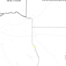
Arkansas
| Local Time | Report Details |
|---|---|
| 7:08 AM CDT | Reports of trees down around moro creek on highway in cleveland county AR, 64.8 miles S of Little Rock, AR |
| 7:10 AM CDT | Trees were reported down in kingslan in cleveland county AR, 59.9 miles S of Little Rock, AR |
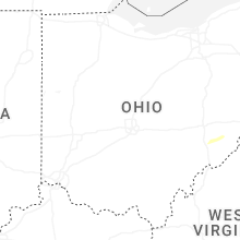
Ohio
| Local Time | Report Details |
|---|---|
| 10:00 AM EDT | Large tree down. time estimated from rada in darke county OH, 66.9 miles N of Cincinnati, OH |
| 10:00 AM EDT | Fences blown ove in darke county OH, 60.6 miles N of Cincinnati, OH |
| 10:00 AM EDT | Fences blown ove in darke county OH, 60.6 miles N of Cincinnati, OH |
| 10:00 AM EDT | Photo of trees and branches dow in darke county OH, 69.1 miles N of Cincinnati, OH |
| 10:02 AM EDT | Barn damaged on york road. power poles down. time estimated from rada in darke county OH, 62.1 miles SSE of Fort Wayne, IN |
| 10:14 AM EDT | Multiple trees down in western miami count in miami county OH, 65.1 miles N of Cincinnati, OH |
| 10:15 AM EDT | Approximately 30 power lines down on staley road. time estimated from radar. possible tornad in shelby county OH, 64.6 miles SE of Fort Wayne, IN |
| 10:15 AM EDT | Barn leveled on 274 and sidney-fryburg roa in shelby county OH, 66.7 miles SE of Fort Wayne, IN |
| 10:20 AM EDT | Videos of barn damage on us 33 west of st john in auglaize county OH, 62.9 miles SE of Fort Wayne, IN |
| 10:20 AM EDT | Reports of barn damage in st johns. time estimated from rada in auglaize county OH, 64.2 miles ESE of Fort Wayne, IN |
| 10:23 AM EDT | Kday aso in montgomery county OH, 57.5 miles NNE of Cincinnati, OH |
| 10:25 AM EDT | Semi-trucks overturned on mile marker 101 on i-7 in shelby county OH, 66 miles SE of Fort Wayne, IN |
| 10:31 AM EDT | Poles and wires down. time estimated from rada in logan county OH, 58.6 miles NW of Columbus, OH |
| 10:31 AM EDT | Numerous power poles down near grand avenue. time estimated from rada in logan county OH, 59 miles NW of Columbus, OH |
| 10:38 AM EDT | Multiple trees down throughout the county. time estimated from rada in champaign county OH, 40.9 miles WNW of Columbus, OH |
| 10:45 AM EDT | Ki95 awo in hardin county OH, 56 miles NW of Columbus, OH |
| 10:52 AM EDT | Krmt awo in union county OH, 26.1 miles NW of Columbus, OH |
| 11:02 AM EDT | 3 power poles snapped and downed near the intersection of richland rd and riviera dr. time estimated via rada in marion county OH, 42.9 miles N of Columbus, OH |
| 11:10 AM EDT | County ema reported a barn blown down and debris was blown northeast across a field. the barn was located along cr 110 west of upper sandusk in wyandot county OH, 62.6 miles NNW of Columbus, OH |
| 11:15 AM EDT | Trained spotter reported an 18 inch diameter tree was blown down in upper sandusky. also... powerlines blown down along with semi blown on the side on hwy 23. in additi in wyandot county OH, 63.5 miles NNW of Columbus, OH |
| 11:15 AM EDT | Erie county 911 reported a downed tree on heywood road in castali in erie county OH, 58.9 miles W of Cleveland, OH |
| 11:23 AM EDT | A few trees/power-lines down throughout the county mainly north of bucyru in crawford county OH, 62.7 miles N of Columbus, OH |
| 11:41 AM EDT | Corrects previous non-tstm wnd gst report from 4 n mansfield. asos station kmfd mansfiel in richland county OH, 64 miles SW of Cleveland, OH |
| 11:50 AM EDT | Tree downed. time estimated via rada in ashland county OH, 55.4 miles SSW of Cleveland, OH |
| 11:52 AM EDT | Electric pole snapped... wires hanging across road. time estimated via rada in ashland county OH, 50.7 miles SW of Cleveland, OH |
| 12:16 PM EDT | Asos station klpr lorain elyri in lorain county OH, 27.6 miles WSW of Cleveland, OH |
| 1:48 PM EDT | Tree down near crooksville. timing estimated from rada in perry county OH, 49.8 miles ESE of Columbus, OH |
| 2:14 PM EDT | Tree down near shawnee. timing estimated from rada in perry county OH, 48.7 miles ESE of Columbus, OH |
| 2:43 PM EDT | Two trees down on state route 284 at the 1 and 3 mile markers. timing estimated from rada in morgan county OH, 69.9 miles ESE of Columbus, OH |
Alabama
| Local Time | Report Details |
|---|---|
| 10:37 AM CDT | Algo traffic reports debris blocking westbound lanes of us-84 before the ms state line near isne in choctaw county AL, 70.3 miles WSW of Camden, AL |
| 11:25 PM CDT | Multiple trees down in clarke county... blocking lanes of us-84 and al- in clarke county AL, 48.2 miles WSW of Camden, AL |
| 11:45 PM CDT | Multiple trees down in clarke county... blocking lanes of us-84 and al- in clarke county AL, 24.1 miles W of Camden, AL |
| 11:54 PM CDT | Reports of multiple trees down across northeastern portions of autauga count in autauga county AL, 50.8 miles NE of Camden, AL |
| 12:25 AM CDT | Multiple trees down in clarke county... blocking lanes of us-84 and al- in clarke county AL, 48.2 miles WSW of Camden, AL |
| 12:38 AM CDT | Multiple trees down in clarke county... blocking lanes of us-84 and al- in clarke county AL, 24.1 miles W of Camden, AL |
| 12:47 AM CDT | Algo traffic reports debris blocking westbound lanes of us-84 before the ms state line near isne in choctaw county AL, 70.3 miles WSW of Camden, AL |
| 6:04 AM UTC | Tree down cr 63 at hwy in coosa county AL, 39.4 miles WNW of Auburn, AL |
| 6:38 AM UTC | Tree down on horseshoe bend rd with deputy respondin in tallapoosa county AL, 28.6 miles NW of Auburn, AL |
| 6:49 AM UTC | Several reports of trees and power lines down around montgomery... including wares ferry at dalraida... forest ave at oak park... and carol villa d in montgomery county AL, 47.3 miles WSW of Auburn, AL |
| 2:46 AM CDT | Tree down on lee road 7 in lee county AL, 7.7 miles NW of Auburn, AL |
| 2:59 AM CDT | Numerous trees reported down across pike count in pike county AL, 62 miles SSW of Auburn, AL |
| 3:03 AM CDT | Tree on a home on terracewood dr... tree and power line down on hunter st... and tree down on veterans pkw in lee county AL, 5.6 miles ENE of Auburn, AL |
| 3:20 AM CDT | Tree down on hwy 23 in bullock county AL, 44.3 miles SSW of Auburn, AL |
| 3:20 AM CDT | Two trees down across lee road 1 in lee county AL, 9.4 miles SSE of Auburn, AL |
| 3:25 AM CDT | Tree down on hwy 51 nort in bullock county AL, 28.1 miles S of Auburn, AL |
| 3:29 AM CDT | Tree down on cr 4 in barbour county AL, 49 miles S of Auburn, AL |
| 3:36 AM CDT | Trees down on hwy 239 near the jail and on cr 1 in barbour county AL, 49.4 miles S of Auburn, AL |
| 3:36 AM CDT | Tree down hwy 80 at north herring r in russell county AL, 16.1 miles SE of Auburn, AL |
| 3:42 AM CDT | Trees down on sid bush rd at bowden rd and on hwy 51 between clayton and louisvill in barbour county AL, 53.7 miles S of Auburn, AL |
| 3:46 AM CDT | Trees down on highway 26 at tammy plac in russell county AL, 26 miles SSE of Auburn, AL |
| 3:50 AM CDT | Tree down with power lines blocking cr 5 in dale county AL, 79.6 miles S of Auburn, AL |
| 3:54 AM CDT | Tree down on east college stree in dale county AL, 79.6 miles S of Auburn, AL |
| 3:55 AM CDT | Trees down on lee road 213... 309... and 24 in lee county AL, 24.5 miles ESE of Auburn, AL |
| 3:59 AM CDT | Tree and debris on roadwa in dale county AL, 80.1 miles NNE of Miramar Beach, FL |
| 3:59 AM CDT | Tree blocking roadway on windmill roa in houston county AL, 72.5 miles NE of Miramar Beach, FL |
| 4:02 AM CDT | Tree down on 5 mile r in barbour county AL, 54.7 miles SSE of Auburn, AL |
| 4:04 AM CDT | Tree and powerlines down across cr 6 in dale county AL, 85.1 miles NE of Miramar Beach, FL |
| 4:05 AM CDT | Tree down on nuckols r in russell county AL, 30.8 miles SE of Auburn, AL |
| 4:06 AM CDT | Power lines down on hwy 431 on barbour creek bridge blocking all four lane in barbour county AL, 54.8 miles SSE of Auburn, AL |
| 4:07 AM CDT | Multiple trees down blocking lanes along brannon stand road and state highway 5 in houston county AL, 81.4 miles NE of Miramar Beach, FL |
| 4:15 AM CDT | Power line and tree dow in houston county AL, 85.7 miles NE of Miramar Beach, FL |
| 4:20 AM CDT | Downed powerline near intersection of floyd and south len in houston county AL, 81.1 miles NE of Miramar Beach, FL |
| 4:22 AM CDT | Tree dow in houston county AL, 83.8 miles NW of Tallahassee, FL |
| 4:24 AM CDT | Tree and powerlines down near cottonwood r in houston county AL, 78.5 miles NW of Tallahassee, FL |
| 4:25 AM CDT | Multiple trees down blocking memphis church roa in houston county AL, 79.1 miles NE of Miramar Beach, FL |
| 4:25 AM CDT | Fallen pine trees blocking wallace blue r in houston county AL, 80.8 miles NW of Tallahassee, FL |
| 5:00 AM CDT | Large fallen tree blocks sid hughes r in houston county AL, 68.9 miles NW of Tallahassee, FL |
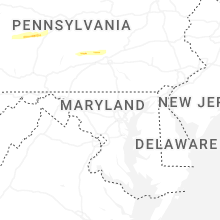
Pennsylvania
| Local Time | Report Details |
|---|---|
| 12:27 PM EDT | Asos station kgkj meadvill in crawford county PA, 76.7 miles E of Cleveland, OH |
| 3:05 PM EDT | Tree down on wire in fayette county PA, 28.6 miles SSE of Pittsburgh, PA |
| 3:05 PM EDT | Quarter sized hail reported near Clymer, PA, 57.4 miles ENE of Pittsburgh, PA, image shared with us on facebook with an estimated measurement. |
| 3:15 PM EDT | Quarter sized hail reported near Connellsville, PA, 35.3 miles SE of Pittsburgh, PA, image shared via a facebook comment. |
| 3:15 PM EDT | Measured at home weather statio in westmoreland county PA, 29.3 miles SE of Pittsburgh, PA |
| 3:29 PM EDT | Ping Pong Ball sized hail reported near Connellsville, PA, 35.3 miles SE of Pittsburgh, PA, corrects time on previous hail report from 3 e everson. image/information from direct message on social media. |
| 3:53 PM EDT | Tree and wires down on camp drive blocking both lanes of traffi in somerset county PA, 61.8 miles ESE of Pittsburgh, PA |
| 4:13 PM EDT | Tree and wires down on quarry road... blocking both lanes of the roadwa in blair county PA, 48 miles SW of State College, PA |
| 4:29 PM EDT | Storm damage reported in blair county PA, 41.8 miles SW of State College, PA |
| 6:28 PM EDT | Trees and wires down in lower paxton township on locust stree in dauphin county PA, 64.5 miles ESE of State College, PA |
| 6:54 PM EDT | Tree down on vehicle near the intersection of north 15th avenue and east lehman stree in lebanon county PA, 74 miles N of Baltimore, MD |
| 7:08 PM EDT | Tree on wires in royalton near ulrich stree in dauphin county PA, 62.3 miles N of Baltimore, MD |
| 7:16 PM EDT | Trees down in bern twp. time estimated from rada in berks county PA, 72.6 miles SSW of Scranton, PA |
| 7:34 PM EDT | Corrects time on previous tstm wnd gst report from 2 ne geistow in cambria county PA, 60.6 miles WSW of State College, PA |
| 7:37 PM EDT | Storm damage reported in cambria county PA, 60.6 miles WSW of State College, PA |
| 7:50 PM EDT | Ping Pong Ball sized hail reported near Connellsville, PA, 35.3 miles SE of Pittsburgh, PA, image/information from direct message on social media. |
| 8:01 PM EDT | Trees down in exeter township. time estimated from rada in berks county PA, 75.8 miles S of Scranton, PA |
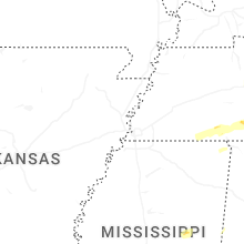
Illinois
| Local Time | Report Details |
|---|---|
| 12:35 PM CDT | Tree down on a power line which has caused some power outage in jefferson county IL, 68.4 miles NNE of Cape Girardeau, MO |
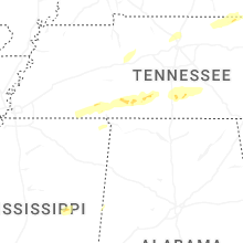
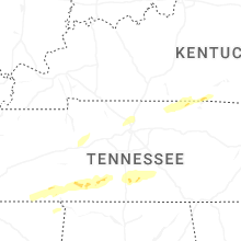
Tennessee
| Local Time | Report Details |
|---|---|
| 12:51 PM CDT | Quarter sized hail reported near Ramer, TN, 56.8 miles WNW of Florence, AL |
| 12:58 PM CDT | Billboard damage and tree limbs dow in mcnairy county TN, 53.3 miles WNW of Florence, AL |
| 1:25 PM CDT | Quarter sized hail reported near Crump, TN, 46.6 miles NW of Florence, AL |
| 1:40 PM CDT | Quarter sized hail reported near Olivehill, TN, 38.1 miles NNW of Florence, AL |
| 2:03 PM CDT | A building in goodletsville lost some roofing materia in davidson county TN, 11.2 miles NNE of Nashville, TN |
| 2:07 PM CDT | Road blocked by tree dow in sumner county TN, 12.8 miles NE of Nashville, TN |
| 2:15 PM CDT | Powerlines down in eastern wayne county... near natchez trac in wayne county TN, 34.8 miles N of Florence, AL |
| 2:18 PM CDT | A window was shattered at the gallatin civic cente in sumner county TN, 25.2 miles NE of Nashville, TN |
| 2:23 PM CDT | Local storm spotter reports winds near 60 mp in lawrence county TN, 36 miles NNE of Florence, AL |
| 2:35 PM CDT | A metal roof was peeled off a portion of a metal buildin in lawrence county TN, 39.5 miles NNE of Florence, AL |
| 2:40 PM CDT | Emergency manager provided pictures of metal roofing off a barn structur in lawrence county TN, 45.2 miles NNE of Florence, AL |
| 2:58 PM CDT | Powerlines/powerpole reported down on mapleash avenue in columbi in maury county TN, 41.2 miles SSW of Nashville, TN |
| 3:06 PM CDT | Local business lost part of its metal roof... peeled up in the win in giles county TN, 44.9 miles NE of Florence, AL |
| 3:06 PM CDT | A few trees down in hermitage spring in clay county TN, 62.5 miles ENE of Nashville, TN |
| 3:15 PM CDT | A few trees down near i-65 exit 22 cornersvill in marshall county TN, 57.1 miles NE of Florence, AL |
| 3:30 PM CDT | Multiple trees snapped and blown over in yar in marshall county TN, 51.7 miles S of Nashville, TN |
| 3:35 PM CDT | A couple trees dow in bedford county TN, 54.7 miles S of Nashville, TN |
| 3:37 PM CDT | Trees uprooted onto a fence on sinking creek road in sw bedford county. time estimated from rada in bedford county TN, 54.7 miles S of Nashville, TN |
| 4:15 PM CDT | A few powerlines downed due to the win in coffee county TN, 53.3 miles NW of Chattanooga, TN |
Texas
| Local Time | Report Details |
|---|---|
| 3:03 PM CDT | Report of tree down on allison cemetery r in tyler county TX, 52.4 miles SSE of Lufkin, TX |
Kentucky
| Local Time | Report Details |
|---|---|
| 3:31 PM CDT | Tree down over part of hwy 10 in cumberland county KY, 82.9 miles S of Louisville, KY |
| 3:55 PM CDT | Multiple trees down and roof blown off a trailer on wisdom dock rd (ky 553 in clinton county KY, 86 miles NW of Knoxville, TN |
| 3:55 PM CDT | Trees down on ky-63 in clinton county KY, 87.3 miles NW of Knoxville, TN |
| 6:06 PM EDT | Storm damage reported in laurel county KY, 42.4 miles S of Irvine, KY |
| 6:11 PM EDT | A tree was reported down near the 1800 block of east laurel road... close to the intersection of ky-158 in laurel county KY, 40.8 miles S of Irvine, KY |
| 6:46 PM EDT | Social media report of several trees down along bowlings creek road near buckhorn. exact address unknown. there were also reports of power outages in this portion of br in breathitt county KY, 37.2 miles SE of Irvine, KY |
| 6:50 PM EDT | Social media report of multiple trees down on the road near the wolf coal fire department building. this is at the intersection of ky 1110 and ky 1933. time estimated v in breathitt county KY, 38.1 miles SE of Irvine, KY |
Virginia
| Local Time | Report Details |
|---|---|
| 5:45 PM EDT | Multiple trees down across southern shenandoah count in shenandoah county VA, 62.6 miles ESE of Elkins, WV |
| 5:48 PM EDT | Tree was down along quicksburg lane and middle brook lan in shenandoah county VA, 64.2 miles ESE of Elkins, WV |
| 5:57 PM EDT | A couple trees were down around stephens city in frederick county VA, 87.7 miles E of Elkins, WV |
| 6:03 PM EDT | A tree was down along salem church roa in clarke county VA, 79.6 miles W of Baltimore, MD |
| 6:10 PM EDT | Tree was down along main street in berryvill in clarke county VA, 74.2 miles W of Baltimore, MD |
| 6:36 PM EDT | A tree was down along taylorstown road and had to be removed from the roadwa in loudoun county VA, 51.6 miles W of Baltimore, MD |
| 6:38 PM EDT | A shed was blown onto the roadway in luckett in loudoun county VA, 49.6 miles W of Baltimore, MD |
| 6:40 PM EDT | Trees down on eastbound va-662 lost corner road near spinks ferry roa in loudoun county VA, 46.9 miles W of Baltimore, MD |
Louisiana
| Local Time | Report Details |
|---|---|
| 5:18 PM CDT | Tree down on hwy 113 south of dry cree in beauregard county LA, 54.3 miles NE of Beaumont, TX |
| 7:12 PM CDT | Avoyelles 911 reports a tree on a vehicle at hwy 107 and rayburns lane in centerpoin in avoyelles county LA, 71.7 miles N of Lafayette, LA |
| 7:13 PM CDT | Roof partially blown off building at 205 s david street in church poin in acadia county LA, 16.9 miles NW of Lafayette, LA |
| 7:13 PM CDT | Tree down across hwy 361 near sabine road near washington... l in st. landry county LA, 39.3 miles N of Lafayette, LA |
| 7:13 PM CDT | Tree reported dow in st. landry county LA, 11 miles N of Lafayette, LA |
| 7:14 PM CDT | Avoyelles 911 reports a tree down in simmespor in avoyelles county LA, 53.8 miles NNE of Lafayette, LA |
| 7:15 PM CDT | Kalb reports a street sign blown down on hwy 181 between lecompte and cheneyvill in rapides county LA, 59 miles NNW of Lafayette, LA |
| 7:18 PM CDT | St landry parish em reports a tree across hwy 35 near the intersection with hwy 190 in lawtel in st. landry county LA, 23.1 miles NNW of Lafayette, LA |
| 7:31 PM CDT | Large tree snapped at base down across st claire drive in church poin in acadia county LA, 18.2 miles NW of Lafayette, LA |
| 8:00 PM CDT | Emergency management reported trees down in zachary on cobb street. time estimated by rada in east baton rouge county LA, 59.6 miles ENE of Lafayette, LA |
| 8:18 PM CDT | Broadcast media reported downed trees via social media post in addis. time estimated by rada in west baton rouge county LA, 45.5 miles ENE of Lafayette, LA |
| 8:22 PM CDT | Broadcast media reports numerous trees and powerlines down northeast of greensburg. possible tornado. time estimated by rada in st. helena county LA, 73 miles NNW of New Orleans, LA |
| 8:31 PM CDT | Emergency management reported trees down in western parts of roseland at richardson and bennett roads. time estimated by rada in tangipahoa county LA, 62.6 miles NNW of New Orleans, LA |
| 8:31 PM CDT | Emergency management reported trees down along state route 1061 and j t conerly rd. time estimated by rada in tangipahoa county LA, 68.5 miles NNW of New Orleans, LA |
| 8:33 PM CDT | Trees down on hwy 51 and arcola rd. time estimated by rada in tangipahoa county LA, 62.5 miles NNW of New Orleans, LA |
| 8:34 PM CDT | Emergency management reported trees down on commercial st and roseland ave in roseland. time estimated by rada in tangipahoa county LA, 61.3 miles NNW of New Orleans, LA |
| 8:37 PM CDT | Power lines reported down on la hwy 43 in northeast livingston. possible tornad in livingston county LA, 54.7 miles NW of New Orleans, LA |
| 8:39 PM CDT | Emergency management reported trees down on la 10 and south river rd near roseland. time estimated by rada in tangipahoa county LA, 62.4 miles NNW of New Orleans, LA |
| 8:41 PM CDT | Trees reported down on la 10 and south river rd near roseland... la. possible tornad in tangipahoa county LA, 62.4 miles NNW of New Orleans, LA |
| 8:45 PM CDT | Emergency management reported trees down along crapanzano rd and cannino rd in western hammond. time estimated by rada in tangipahoa county LA, 46.8 miles NNW of New Orleans, LA |
| 8:47 PM CDT | Emergency management reports trees down along briar patch cemetery rd and neal rd east of amite city. time estimated by rada in tangipahoa county LA, 54.9 miles NNW of New Orleans, LA |
| 8:57 PM CDT | Emergency management reports trees down at us 190 at hart road in hammond. time estimated by rada in tangipahoa county LA, 44 miles NNW of New Orleans, LA |
| 8:59 PM CDT | Emergency management reported trees down on macedonia rd near springfield. time estimated by rada in tangipahoa county LA, 43.4 miles NW of New Orleans, LA |
| 8:59 PM CDT | Emergency management reported trees down along yokum rd and i-12 service rd in hammond. time estimated by rada in tangipahoa county LA, 42.2 miles NNW of New Orleans, LA |
| 9:07 PM CDT | Emergency management reported roof blown off florist shop in franklinton. possible tornado. time estimated by rada in washington county LA, 60.5 miles N of New Orleans, LA |
| 9:09 PM CDT | Public reported trees down on north thibodeaux road south of robert... la. time estimated by rada in tangipahoa county LA, 37.5 miles NNW of New Orleans, LA |
Maryland
| Local Time | Report Details |
|---|---|
| 6:40 PM EDT | Barn roof blown off and wires down in the 10400 block of md-194 woodsboro pik in frederick county MD, 41.2 miles WNW of Baltimore, MD |
| 6:48 PM EDT | Trees down blocking md-355 frederick road near prescott roa in montgomery county MD, 37.6 miles W of Baltimore, MD |
| 6:49 PM EDT | Several large tree limbs down along md-84 south clear ridge road north of md-75 green valley roa in carroll county MD, 33 miles NW of Baltimore, MD |
| 6:50 PM EDT | Several trees... wires... and large limbs down around clarksburg to damascu in montgomery county MD, 36.1 miles W of Baltimore, MD |
| 6:50 PM EDT | A tree was down along linthicum roa in frederick county MD, 39.7 miles W of Baltimore, MD |
| 6:51 PM EDT | Multiple trees... wires... and large limbs down near the intersection of md-84 south clear ridge road and md-75 green valley roa in carroll county MD, 33 miles NW of Baltimore, MD |
| 6:52 PM EDT | Several shingles and shutters blown off house just east of downtown damascu in montgomery county MD, 31.7 miles W of Baltimore, MD |
| 6:52 PM EDT | Numerous large tree limbs several inches in diameter snapped and blew in from neighbor's yar in montgomery county MD, 33.3 miles W of Baltimore, MD |
| 6:53 PM EDT | Multiple trees... wires... and large limbs down near the intersection of md-84 south clear ridge road and md-75 green valley roa in carroll county MD, 33 miles NW of Baltimore, MD |
| 6:54 PM EDT | Large tree down on hawkins creamery roa in montgomery county MD, 30.1 miles W of Baltimore, MD |
| 6:57 PM EDT | Trees down blocking md-94 woodbine road near annapolis rock roa in howard county MD, 27.9 miles W of Baltimore, MD |
| 6:57 PM EDT | Large branches down near the intersection of key street and north stree in carroll county MD, 28 miles NW of Baltimore, MD |
| 6:59 PM EDT | Multiple trees and wires down on md-94 woodbine road near florence road... and across western howard county to md-144 frederick roa in howard county MD, 26.9 miles W of Baltimore, MD |
| 7:02 PM EDT | Several trees and wires down in the germantown/gaithersburg are in montgomery county MD, 34.8 miles WSW of Baltimore, MD |
| 7:03 PM EDT | Several windows blown out... numerous trees down... and siding damage to at least one house near the intersection of daisy road and md-144 frederick roa in howard county MD, 24.3 miles W of Baltimore, MD |
| 7:04 PM EDT | Trees and wires down along md-144 frederick road between morgan station road and md-97 roxbury mills roa in howard county MD, 23.2 miles W of Baltimore, MD |
| 7:05 PM EDT | Trees down on bushy park road between md-144 frederick road and millers mill roa in howard county MD, 22.6 miles W of Baltimore, MD |
| 7:05 PM EDT | Trees down near the intersection of md-97 roxbury mills road and md-144 frederick roa in howard county MD, 22.1 miles W of Baltimore, MD |
| 7:06 PM EDT | Trees down on md-144 frederick road near pfefferkorn roa in howard county MD, 19.9 miles W of Baltimore, MD |
| 7:07 PM EDT | Multiple trees down at spotter's home location on grinstead cour in howard county MD, 20 miles W of Baltimore, MD |
| 7:07 PM EDT | Multiple trees down at spotter's home location on grinstead cour in howard county MD, 20 miles W of Baltimore, MD |
| 7:09 PM EDT | Large trees down on howard lodge driver... river road... and taylor park roa in howard county MD, 18 miles W of Baltimore, MD |
| 7:10 PM EDT | Trees and wires down along md-32 sykesville road between river road and deer hill roa in howard county MD, 19.2 miles WNW of Baltimore, MD |
| 7:11 PM EDT | Trees and large branches down on henrytown road approaching arrington roa in carroll county MD, 17.3 miles WNW of Baltimore, MD |
| 7:11 PM EDT | Trees down onto houses in the 1300 to 1500 block of driver roa in howard county MD, 15.8 miles W of Baltimore, MD |
| 7:23 PM EDT | Tree and lines down on cross country boulevar in baltimore city county MD, 7 miles NW of Baltimore, MD |
| 7:23 PM EDT | Several calls for trees/wires down near lochearn... including at and wildwood avenue and lochearn driv in baltimore county MD, 7.2 miles NW of Baltimore, MD |
| 7:23 PM EDT | Several calls for trees/wires down in the pikesville area... including near the intersection of greenspring avenue and quarry lake drive in baltimore county MD, 8.1 miles NNW of Baltimore, MD |
| 8:04 PM EDT | Tree down blocking a road in the community of fairlee. time estimated from rada in kent county MD, 24.1 miles ESE of Baltimore, MD |
| 8:05 PM EDT | Two trees down on irishtown road and two trees down on frenchtown roa in cecil county MD, 41.9 miles ENE of Baltimore, MD |
| 8:07 PM EDT | Multiple trees and wires down on md-94 woodbine road near florence road... and across western howard county to md-144 frederick roa in howard county MD, 26.9 miles W of Baltimore, MD |
| 8:13 PM EDT | Trees and wires down along md-32 sykesville road between river road and deer hill roa in howard county MD, 19.2 miles WNW of Baltimore, MD |
| 8:15 PM EDT | A wind gust of 51 knots (59 mph) was measured by a mesonet at the north east landfill (de052 in cecil county MD, 43.1 miles ENE of Baltimore, MD |
Mississippi
| Local Time | Report Details |
|---|---|
| 6:35 PM CDT | Report of downed powerline and downed tree on liberty rd near natche in adams county MS, 86.8 miles SW of Jackson, MS |
| 7:01 PM CDT | Law enforcement reported multiple trees and powerlines down in across southwest portions of franklin m in franklin county MS, 82.7 miles SW of Jackson, MS |
| 7:10 PM CDT | Tree down across meadville-gloster r in franklin county MS, 73.3 miles SW of Jackson, MS |
| 7:19 PM CDT | Multiple trees and powerlines down across south central franklin m in franklin county MS, 73.4 miles SSW of Jackson, MS |
| 7:34 PM CDT | Trees and powerlines down across portions of southwest franklin county m in franklin county MS, 68.5 miles SSW of Jackson, MS |
| 7:37 PM CDT | Damage reported on hwy 570... hwy 569... and thompson road. possible tornad in amite county MS, 75.9 miles SSW of Jackson, MS |
| 7:45 PM CDT | Couple trees and power lines down in the sw part of the count in lincoln county MS, 67.7 miles SSW of Jackson, MS |
| 8:00 PM CDT | Numerous trees and power lines down in lincoln county... including the ruth are in lincoln county MS, 63.8 miles S of Jackson, MS |
| 8:05 PM CDT | Trees downed on mallalieu d in lincoln county MS, 61.5 miles S of Jackson, MS |
| 8:06 PM CDT | Trees downed onto a house and onto a vehicle along crestwood l in lincoln county MS, 64.1 miles S of Jackson, MS |
| 8:09 PM CDT | Tree downed across topeka-jayess r in lawrence county MS, 64.7 miles S of Jackson, MS |
| 8:44 PM CDT | Multiple trees and powerlines downed across jefferson davis co. a roof was blown off a carwash in bassfield. possible tornad in jefferson davis county MS, 60.8 miles SSE of Jackson, MS |
| 8:48 PM CDT | Local law enforcement reported multiple trees down across west covington m in covington county MS, 52.3 miles SSE of Jackson, MS |
| 8:56 PM CDT | Multiple trees down across central covington county m in covington county MS, 58.7 miles SE of Jackson, MS |
| 9:01 PM CDT | Power lines downed along dosh r in covington county MS, 65 miles SE of Jackson, MS |
| 9:10 PM CDT | Tree downed on morning star r in jones county MS, 63.9 miles SE of Jackson, MS |
| 9:12 PM CDT | Power line downed on purvis oloh r in lamar county MS, 78.6 miles SSE of Jackson, MS |
| 9:20 PM CDT | Multiple trees down around hwy 589 & hwy 9 in lamar county MS, 79.3 miles SSE of Jackson, MS |
| 9:27 PM CDT | Tree downed on a house along cr 2 in jasper county MS, 69.9 miles ESE of Jackson, MS |
| 9:27 PM CDT | Widespread downed trees across northern and central lamar count in lamar county MS, 81.3 miles SE of Jackson, MS |
| 9:28 PM CDT | Tree downed across augusta r in jones county MS, 75.5 miles SE of Jackson, MS |
| 9:33 PM CDT | A storm spotter reported multiple trees down near laurel ms. hwy 15 is impassable due to fallen trees. possible tornad in jones county MS, 75.5 miles SE of Jackson, MS |
| 9:38 PM CDT | Multiple trees and power lines downed across northern forrest co in the hattiesburg... petal... macedonia... and sunrise area in forrest county MS, 84.8 miles SE of Jackson, MS |
| 9:40 PM CDT | A few trees downed across southern lamar c in lamar county MS, 86.4 miles WNW of Mobile, AL |
| 9:56 PM CDT | Emergency management reported trees down near mcneill on henleyfield mcneill rd. time estimated by rada in pearl river county MS, 54.6 miles NNE of New Orleans, LA |
| 9:57 PM CDT | Emergency management reported trees down on oak point road. time estimated by rada in pearl river county MS, 45.8 miles NNE of New Orleans, LA |
| 10:03 PM CDT | Emergency management reported trees down on rock ranch and george ford roads. time estimated by rada in pearl river county MS, 51.5 miles NNE of New Orleans, LA |
| 10:18 PM CDT | Roof blown off a house on grady slade r in forrest county MS, 73.2 miles WNW of Mobile, AL |
| 10:35 PM CDT | Reports of a few trees down in wiggins and just north of wiggin in stone county MS, 65.7 miles W of Mobile, AL |
Delaware
| Local Time | Report Details |
|---|---|
| 8:19 PM EDT | Corrects previous tstm wnd dmg report from newark. transformer blown on old harmony roa in new castle county DE, 52.8 miles ENE of Baltimore, MD |
| 8:32 PM EDT | Mesonet station del13 us 1 at appoquinimink rive in new castle county DE, 51.9 miles ENE of Baltimore, MD |
| 8:35 PM EDT | Transformer blown on old harmony roa in new castle county DE, 52.8 miles ENE of Baltimore, MD |
New Jersey
| Local Time | Report Details |
|---|---|
| 8:51 PM EDT | Downed tree on nj 77 southbound south of cr 538/elk rd (elk twp)... 1 right lane of 2 lanes... right shoulder closed. time estimated from rada in gloucester county NJ, 79.5 miles ENE of Baltimore, MD |
| 8:52 PM EDT | Numerous trees down in gloucester county... including near pittman. time estimate in gloucester county NJ, 84.7 miles ENE of Baltimore, MD |
| 8:53 PM EDT | Few trees down along mullica hill road; both full size soccer nets and benches on the turf flipped over at south jersey technical colleg in gloucester county NJ, 80.5 miles ENE of Baltimore, MD |
| 8:55 PM EDT | Trees and wires down in chester township. time estimated from rada in morris county NJ, 36.7 miles W of Brooklyn, NY |
| 8:55 PM EDT | Numerous trees down in gloucester county... including near glassboro. time estimate in gloucester county NJ, 85 miles ENE of Baltimore, MD |
| 8:56 PM EDT | Numerous trees down in gloucester county... including in washington township. time estimate in gloucester county NJ, 86.9 miles SW of Brooklyn, NY |
| 8:57 PM EDT | Trees and wires down in mine hill. time estimated from rada in morris county NJ, 34 miles WNW of Brooklyn, NY |
| 8:58 PM EDT | 62 mph wind gust with branches knocked over from straight line winds. cloud to ground lightning. time estimated from rada in salem county NJ, 79.5 miles ENE of Baltimore, MD |
| 9:02 PM EDT | Numerous trees down in gloucester county... including near clayton. time estimate in gloucester county NJ, 85.1 miles ENE of Baltimore, MD |
| 9:04 PM EDT | Numerous trees down in gloucester county... including near malaga. time estimate in gloucester county NJ, 85.2 miles N of Ocean City, MD |
| 9:04 PM EDT | Trees and wires down in gloucester township. time estimated from rada in camden county NJ, 81.9 miles SW of Brooklyn, NY |
| 9:04 PM EDT | Trees and wires down in mendham. time estimated from rada in morris county NJ, 32.6 miles W of Brooklyn, NY |
| 9:07 PM EDT | Downed pole/wires on us 30 both directions east of cr 645/graisbury av (audubon)... all lanes closed eastbound; all lanes closed westbound. time estimated from rada in camden county NJ, 79.1 miles SW of Brooklyn, NY |
| 9:07 PM EDT | Numerous trees down across gloucester county... including near newfield. time estimate in gloucester county NJ, 83.2 miles N of Ocean City, MD |
| 9:07 PM EDT | Trees and wires down in stratford. time estimated from rada in camden county NJ, 80.3 miles SW of Brooklyn, NY |
| 9:09 PM EDT | Trees and wires down in harding township. time estimated from rada in morris county NJ, 27 miles W of Brooklyn, NY |
| 9:12 PM EDT | Trees and wires down in cherry hill. time estimated from rada in camden county NJ, 75.7 miles SW of Brooklyn, NY |
| 9:14 PM EDT | Trees and wires down in evesham. time estimated from rada in burlington county NJ, 73.7 miles SW of Brooklyn, NY |
| 9:16 PM EDT | Trees and wires down in medford. time estimated from rada in burlington county NJ, 70.6 miles SW of Brooklyn, NY |
| 9:16 PM EDT | Trees and wires down in tabernacle. time estimated from rada in burlington county NJ, 70 miles SSW of Brooklyn, NY |
| 9:18 PM EDT | Wires down along tuckerton road in medford. time estimated from rada in burlington county NJ, 72.7 miles SW of Brooklyn, NY |
Georgia
| Local Time | Report Details |
|---|---|
| 6:39 AM EDT | Storm damage reported in decatur county GA, 36.7 miles NNW of Tallahassee, FL |
| 6:40 AM EDT | Tree down near ga hwy 31 in mitchell county GA, 48.3 miles NNW of Tallahassee, FL |
| 7:15 AM EDT | Mesonet station uga23 cair in grady county GA, 29.1 miles N of Tallahassee, FL |
| 7:30 AM EDT | Mesonet station uga03 tifto in tift county GA, 40.2 miles W of Douglas, GA |
Florida
| Local Time | Report Details |
|---|---|
| 7:15 AM EDT | Tree blocking both lanes on fairbanks ferry r in gadsden county FL, 15.7 miles NNW of Tallahassee, FL |
Connect with Interactive Hail Maps