

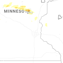
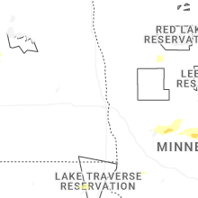
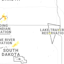
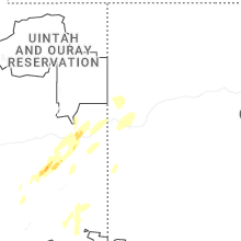
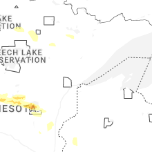
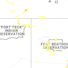
Hail Map for Friday, September 12, 2025
Number of Impacted Households on 9/12/2025
0
Impacted by 1" or Larger Hail
0
Impacted by 1.75" or Larger Hail
0
Impacted by 2.5" or Larger Hail
Square Miles of Populated Area Impacted on 9/12/2025
0
Impacted by 1" or Larger Hail
0
Impacted by 1.75" or Larger Hail
0
Impacted by 2.5" or Larger Hail
Cities Most Affected by Hail Storms of 9/12/2025
| Hail Size | Demographics of Zip Codes Affected | ||||||
|---|---|---|---|---|---|---|---|
| City | Count | Average | Largest | Pop Density | House Value | Income | Age |
| Watauga, SD | 1 | 1.75 | 1.75 | 0 | $10k | $41.3k | 43.8 |
Hail and Wind Damage Spotted on 9/12/2025
Filter by Report Type:Hail ReportsWind Reports
States Impacted
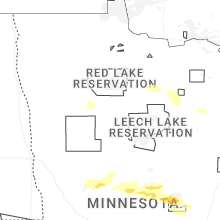
Minnesota, Utah, North Dakota, Colorado, Arizona, New Mexico, Wyoming, Montana, South DakotaMinnesota
| Local Time | Report Details |
|---|---|
| 8:42 AM CDT | Quarter sized hail reported near New York Mills, MN, 74 miles SSW of Bemidji, MN, time estimated from radar. |
| 10:28 AM CDT | Quarter sized hail reported near Motley, MN, 76.7 miles S of Bemidji, MN, heavy rain and hail falling. hail was accumulating and looked like snow outside. hail was marble size to quarter size. |
| 10:37 AM CDT | Quarter sized hail reported near Brainerd, MN, 78.6 miles SSE of Bemidji, MN |
| 11:00 AM CDT | Quarter sized hail reported near Pillager, MN, 80 miles SSE of Bemidji, MN, gusty east winds followed by very heavy rain and hail at time of observation. hail was mostly dime size but there were a few quarter size hailstones at times. |
| 11:11 AM CDT | Ping Pong Ball sized hail reported near Brainerd, MN, 82.6 miles SSE of Bemidji, MN, location is approximate near the brainerd airport. trained spotter reported very strong winds and very heavy rain and large hail that was quarter size and up to an inch |
| 11:39 AM CDT | Half Dollar sized hail reported near Brainerd, MN, 83.8 miles SSE of Bemidji, MN, trained spotter reported quarter size to slightly larger than quarter size hail at central lakes college near college drive and the mississippi river. |
Utah
| Local Time | Report Details |
|---|---|
| 9:06 AM MDT | Quarter sized hail reported near , , 57.4 miles W of Grand Junction, CO |
| 9:44 AM MDT | Half Dollar sized hail reported near , , 67.4 miles WSW of Grand Junction, CO |
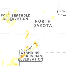
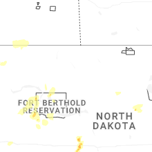
North Dakota
| Local Time | Report Details |
|---|---|
| 10:19 AM CDT | Quarter sized hail reported near Fessenden, ND, 47.7 miles SW of Devils Lake, ND, brief period of nickel to quarter sized hail followed by a brief period of heavy rain. time estimated based on radar. |
| 3:48 PM MDT | Quarter sized hail reported near Bowman, ND, 113.6 miles ESE of Miles City, MT, ground was white with hail... and some hail still remained at the time of this report. mostly smaller than quarter... but quarter size was the largest. |
| 6:00 PM CDT | Ping Pong Ball sized hail reported near Solen, ND, 28.7 miles S of Bismarck, ND, also rained 2.4 inches from the storm. |
| 6:15 PM CDT | Half Dollar sized hail reported near Solen, ND, 25.1 miles SSW of Bismarck, ND, relayed to nws by broadcast media partner. |
| 5:25 PM MDT | Quarter sized hail reported near Raleigh, ND, 48.5 miles SW of Bismarck, ND, ground was white with hail. also received 0.80 inch of rain. |
| 6:25 PM CDT | Half Dollar sized hail reported near Solen, ND, 28.7 miles S of Bismarck, ND, hailed for about 20 minutes... mainly before this time of the half dollar hail. some hail also fell off and on after this time. |
| 7:10 PM CDT | Quarter sized hail reported near Fort Yates, ND, 38.1 miles S of Bismarck, ND, mainly smaller hail but a few around the size of a quarter. |
| 8:12 PM CDT | Quarter sized hail reported near New Salem, ND, 30.6 miles W of Bismarck, ND |
Colorado
| Local Time | Report Details |
|---|---|
| 11:30 AM MDT | Storm damage reported in mesa county CO, 23.7 miles NW of Grand Junction, CO |
| 3:06 PM MDT | Power lines down due to thunderstorm wind in mesa county CO, 10.9 miles NW of Grand Junction, CO |
| 3:12 PM MDT | Asos station kgjt grand junction rgnl a in mesa county CO, 4.3 miles NNE of Grand Junction, CO |
| 4:34 PM MDT | Asos station kril garfield county rgnl a in garfield county CO, 54.9 miles NE of Grand Junction, CO |
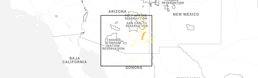
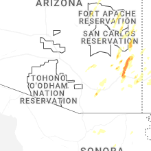
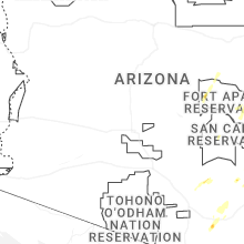
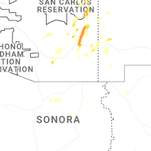
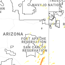
Arizona
| Local Time | Report Details |
|---|---|
| 11:25 AM MST | Quarter sized hail reported near San Manuel, AZ, 33.7 miles NE of Tucson, AZ, several photos and videos showing quarter size hail in san manuel. |
| 11:30 AM MST | Quarter sized hail reported near San Manuel, AZ, 33.3 miles NE of Tucson, AZ, photo and video of numerous 1 inch hail stones via facebook. |
| 3:41 PM MST | Weather station recorded wind gust of 60 mp in cochise county AZ, 69.5 miles N of Douglas, AZ |
| 3:47 PM MST | Report of overturned semitruc in cochise county AZ, 70.3 miles N of Douglas, AZ |
| 4:00 PM MST | Ping Pong Ball sized hail reported near Willcox, AZ, 70.3 miles N of Douglas, AZ, estimated hail size of 1.5 inches with hail accumulation covering the roadways of roughly 8 inches deep. |
| 4:24 PM MST | Ping Pong Ball sized hail reported near , , 75.8 miles N of Douglas, AZ, estimated 1.5 inch hail along highway 191. |
| 5:25 PM MST | Guthrie raws measured wind gust of 63 mph. time estimated based on rada in greenlee county AZ, 60.7 miles W of Silver City, NM |
| 11:03 PM MST | Asos station ksad gusted to 58 mp in graham county AZ, 79 miles W of Silver City, NM |
New Mexico
| Local Time | Report Details |
|---|---|
| 2:30 PM MDT | Mesonet station nm003 lordsburg playa i10 mp11 (nmdot in hidalgo county NM, 48.9 miles SW of Silver City, NM |
| 3:56 PM MDT | Storm damage reported in bernalillo county NM, 7.3 miles NW of Albuquerque, NM |
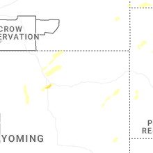
Wyoming
| Local Time | Report Details |
|---|---|
| 4:55 PM MDT | Quarter sized hail reported near Buffalo, WY, 55 miles W of Gillette, WY, called report in and social media photo. |
Montana
| Local Time | Report Details |
|---|---|
| 5:36 PM MDT | Ping Pong Ball sized hail reported near Redstone, MT, 73.2 miles NW of Williston, ND, 1.5 inch hail estimated from photo via social media. |
| 7:35 PM MDT | Quarter sized hail reported near Dagmar, MT, 40.5 miles NW of Williston, ND, 1 inch hail 4 miles outside dagmar via social media. |
| 10:47 PM MDT | Corrects previous non-tstm wnd gst report from 1 se baker. asos station kbhk bake in fallon county MT, 76.5 miles E of Miles City, MT |
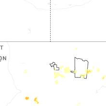
South Dakota
| Local Time | Report Details |
|---|---|
| 5:58 PM MDT | Golf Ball sized hail reported near Watauga, SD, 82.6 miles SSW of Bismarck, ND, golf-ball hail for about 15 minutes. flooding of the yard. |
| 6:05 PM MDT | Quarter sized hail reported near Morristown, SD, 85.1 miles SSW of Bismarck, ND, time estimated. |
| 11:20 PM MDT | Storm damage reported in haakon county SD, 71.3 miles ENE of Rapid City, SD |
| 11:21 PM MDT | Storm damage reported in ziebach county SD, 71.6 miles ENE of Rapid City, SD |
| 11:25 PM MDT | Storm damage reported in haakon county SD, 71.3 miles ENE of Rapid City, SD |
| 11:26 PM MDT | Storm damage reported in ziebach county SD, 71.6 miles ENE of Rapid City, SD |
| 11:31 PM MDT | Storm damage reported in ziebach county SD, 71.6 miles ENE of Rapid City, SD |
| 3:07 AM MDT | Storm damage reported in meade county SD, 69.3 miles ENE of Rapid City, SD |
| 3:35 AM MDT | Storm damage reported in meade county SD, 88.7 miles NE of Rapid City, SD |
| 4:30 AM MDT | Sd mesonet eagle butte sit in dewey county SD, 57.6 miles NW of Pierre, SD |
Connect with Interactive Hail Maps