

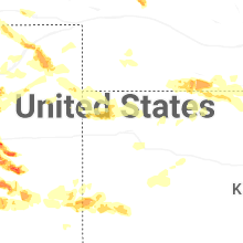
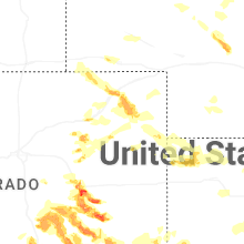
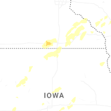
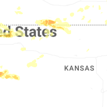
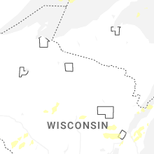
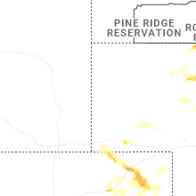
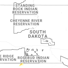
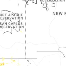
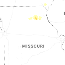
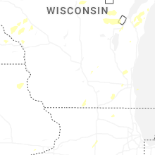
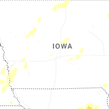
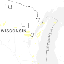
Hail Map for Saturday, August 9, 2025

Number of Impacted Households on 8/9/2025
0
Impacted by 1" or Larger Hail
0
Impacted by 1.75" or Larger Hail
0
Impacted by 2.5" or Larger Hail
Square Miles of Populated Area Impacted on 8/9/2025
0
Impacted by 1" or Larger Hail
0
Impacted by 1.75" or Larger Hail
0
Impacted by 2.5" or Larger Hail
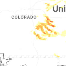
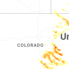
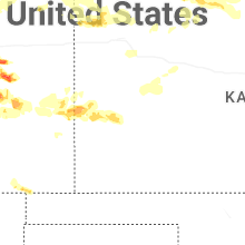
Cities Most Affected by Hail Storms of 8/9/2025
| Hail Size | Demographics of Zip Codes Affected | ||||||
|---|---|---|---|---|---|---|---|
| City | Count | Average | Largest | Pop Density | House Value | Income | Age |
| Hugo, CO | 10 | 2.18 | 3.00 | 0 | $71k | $31.3k | 46.8 |
| Karval, CO | 7 | 2.89 | 4.00 | 0 | $40k | $29.5k | 46.4 |
| Limon, CO | 7 | 2.43 | 3.00 | 2 | $88k | $35.1k | 38.2 |
| Matheson, CO | 3 | 2.08 | 2.50 | 1 | $75k | $37.2k | 51.0 |
| Rush, CO | 2 | 2.38 | 3.00 | 1 | $105k | $34.3k | 43.5 |
| Wray, CO | 2 | 1.75 | 1.75 | 5 | $72k | $33.4k | 39.1 |
| Ordway, CO | 1 | 3.30 | 3.30 | 4 | $56k | $25.3k | 40.0 |
| Yuma, CO | 1 | 2.00 | 2.00 | 7 | $84k | $32.3k | 37.1 |
| Eckley, CO | 1 | 2.00 | 2.00 | 2 | $50k | $25.5k | 41.6 |
| Pueblo, CO | 1 | 1.75 | 1.75 | 853 | $86k | $28.4k | 34.3 |
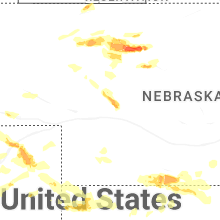
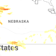
| Thedford, NE | 1 | 1.75 | 1.75 | 0 | $39k | $31.7k | 46.4 |
Hail and Wind Damage Spotted on 8/9/2025
Filter by Report Type:Hail ReportsWind Reports
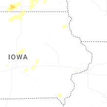
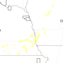
Iowa
| Local Time | Report Details |
|---|---|
| 7:05 AM CDT | Barn blown down and damage to tree in shelby county IA, 50.9 miles NE of Omaha, NE |
| 7:05 AM CDT | Tree blown dow in monona county IA, 47 miles SSW of Storm Lake, IA |
| 7:07 AM CDT | Emergency manager reported a snapped light pole and a tree down in manilla. time estimated from rada in crawford county IA, 52.3 miles S of Storm Lake, IA |
| 7:10 AM CDT | Large tree... unclear is rotted or healthy... snapped at base. few other small branches in town snapped. delayed report... time estimated by rada in carroll county IA, 34.2 miles SSE of Storm Lake, IA |
| 7:15 AM CDT | Large pine uprooted and garage doors pushed in. delayed report via social media... time given in social media post and confirmed by rada in carroll county IA, 45.4 miles SSE of Storm Lake, IA |
| 7:18 AM CDT | Measured from personal weather statio in crawford county IA, 44.1 miles S of Storm Lake, IA |
| 7:19 AM CDT | Large tree down at this location... few others reported in town. time estimated by rada in webster county IA, 53.8 miles E of Storm Lake, IA |
| 7:20 AM CDT | Emergency manager reported trees down in halbur. time estimated from rada in carroll county IA, 45.6 miles SSE of Storm Lake, IA |
| 7:22 AM CDT | Emergency manager reported significant damage to a barn south of westside. time estimated by rada in crawford county IA, 42.3 miles S of Storm Lake, IA |
| 7:22 AM CDT | Emergency manager reported damage to sheds and outbuildings. time estimated from rada in carroll county IA, 41.4 miles SSE of Storm Lake, IA |
| 7:26 AM CDT | Emergency manager reported large trees down in swan lake state park. time estimated from rada in carroll county IA, 45.6 miles SSE of Storm Lake, IA |
| 7:28 AM CDT | Measured from personal weather statio in carroll county IA, 40 miles SSE of Storm Lake, IA |
| 7:29 AM CDT | Measured gust from awos. time of peak gust estimated from rada in carroll county IA, 46.3 miles SSE of Storm Lake, IA |
| 7:38 AM CDT | Fire department reported estimated winds between 65 and 70 mph over the last 15 minute in carroll county IA, 45.6 miles SSE of Storm Lake, IA |
| 7:50 AM CDT | Delayed report: a personal weather station just southeast of galva recorded a 59 mph wind gust. (site: pws-kiaschal7 in ida county IA, 16.5 miles SSW of Storm Lake, IA |
| 8:27 AM CDT | Report of trees and branches down across town... via social media. time estimated by rada in humboldt county IA, 50.2 miles E of Storm Lake, IA |
| 3:28 AM CDT | Measured via public mesonet statio in mills county IA, 27.1 miles SE of Omaha, NE |
| 3:37 AM CDT | Emergency manager report of an overturned semi in retail lot. time based on rada in page county IA, 45.3 miles SE of Omaha, NE |
| 3:46 AM CDT | Measured via public mesonet statio in page county IA, 46.3 miles SE of Omaha, NE |
| 5:07 AM CDT | Measured by personal weather statio in dallas county IA, 20.5 miles W of Des Moines, IA |
Nebraska
| Local Time | Report Details |
|---|---|
| 7:15 AM CDT | Public report relayed via social media of large trees down. time estimated from rada in douglas county NE, 10.6 miles W of Omaha, NE |
| 5:18 PM CDT | Golf Ball sized hail reported near Thedford, NE, 40.5 miles S of Valentine, NE, golf ball size hail and 57 mph winds. |
| 6:37 PM MDT | Quarter sized hail reported near Haigler, NE, 42.2 miles E of Yuma, CO, law enforcement estimated 1 inch hail 45-50 mph winds in haigler. |
| 11:04 PM CDT | Storm damage reported in harlan county NE, 75.1 miles SW of Grand Island, NE |
| 12:27 AM CDT | 2 meter wind from nebraska mesonet statio in webster county NE, 57.7 miles S of Grand Island, NE |
| 12:31 AM CDT | Tempest weather statio in webster county NE, 43.9 miles S of Grand Island, NE |
| 12:34 AM CDT | Storm damage reported in nuckolls county NE, 54 miles S of Grand Island, NE |
| 12:39 AM CDT | Storm damage reported in nuckolls county NE, 61.8 miles SSE of Grand Island, NE |
| 12:42 AM CDT | Storm damage reported in nuckolls county NE, 47.1 miles SSE of Grand Island, NE |
| 12:45 AM CDT | Delayed... estimated report of 90 mph winds in superior. time estimated based on surrounding weather station observation in nuckolls county NE, 64 miles SSE of Grand Island, NE |
| 12:50 AM CDT | Storm damage reported in nuckolls county NE, 59.5 miles SSE of Grand Island, NE |
| 12:50 AM CDT | Davis weather station. station stopped reporting shortly after thi in nuckolls county NE, 58.7 miles SSE of Grand Island, NE |
| 12:51 AM CDT | Davis weather statio in nuckolls county NE, 52 miles SSE of Grand Island, NE |
| 12:54 AM CDT | Davis weather station. station stopped reporting at this time. peak gust likely highe in thayer county NE, 68.9 miles SSE of Grand Island, NE |
| 12:58 AM CDT | Storm damage reported in thayer county NE, 59.3 miles SSE of Grand Island, NE |
| 12:59 AM CDT | Storm damage reported in thayer county NE, 59.2 miles SSE of Grand Island, NE |
| 1:05 AM CDT | Several large trees downe in thayer county NE, 55.3 miles SE of Grand Island, NE |
| 1:06 AM CDT | 55 yr old blue spruce tree blown over. report via facebook. time estimated from rada in thayer county NE, 55.4 miles SSE of Grand Island, NE |
| 1:06 AM CDT | Storm damage reported in thayer county NE, 55.4 miles SE of Grand Island, NE |
| 1:07 AM CDT | Storm damage reported in thayer county NE, 56.8 miles SE of Grand Island, NE |
| 1:07 AM CDT | Davis weather statio in thayer county NE, 62.6 miles SSE of Grand Island, NE |
| 1:08 AM CDT | Pws station knecarle5. station stopped reporting at this time and peak wind may have been highe in thayer county NE, 57.4 miles SE of Grand Island, NE |
| 1:09 AM CDT | Storm damage reported in thayer county NE, 67.6 miles SE of Grand Island, NE |
| 1:10 AM CDT | Storm damage reported in thayer county NE, 55.6 miles SE of Grand Island, NE |
| 1:10 AM CDT | Storm damage reported in thayer county NE, 57.8 miles SE of Grand Island, NE |
| 1:14 AM CDT | Storm damage reported in thayer county NE, 58.2 miles SE of Grand Island, NE |
| 1:14 AM CDT | Storm damage reported in thayer county NE, 71.3 miles SSE of Grand Island, NE |
| 1:15 AM CDT | Davis weather station. continued severe gusts behind the stronger push of wind in nuckolls county NE, 56.5 miles SSE of Grand Island, NE |
| 1:15 AM CDT | Storm damage reported in thayer county NE, 53.7 miles SE of Grand Island, NE |
| 1:15 AM CDT | Davis weather statio in thayer county NE, 54.3 miles SE of Grand Island, NE |
| 1:18 AM CDT | Snapped trees and large branches down in tow in thayer county NE, 73.6 miles SSE of Grand Island, NE |
| 1:21 AM CDT | Storm damage reported in thayer county NE, 56.9 miles SE of Grand Island, NE |
| 1:30 AM CDT | Storm damage reported in fillmore county NE, 60 miles SE of Grand Island, NE |
| 1:30 AM CDT | Storm damage reported in thayer county NE, 58.2 miles SE of Grand Island, NE |
| 1:30 AM CDT | Storm damage reported in thayer county NE, 56.9 miles SE of Grand Island, NE |
| 1:33 AM CDT | Storm damage reported in fillmore county NE, 60 miles SE of Grand Island, NE |
| 1:40 AM CDT | Storm damage reported in fillmore county NE, 55.4 miles SE of Grand Island, NE |
| 1:45 AM CDT | Davis weather station. continued severe winds behind main lin in fillmore county NE, 60 miles SE of Grand Island, NE |
| 1:48 AM CDT | Storm damage reported in jefferson county NE, 76 miles SE of Grand Island, NE |
| 1:50 AM CDT | Measured from a public mesonet statio in jefferson county NE, 80.6 miles NNW of Manhattan, KS |
| 2:34 AM CDT | Measured from public mesonet statio in lancaster county NE, 58.9 miles SW of Omaha, NE |
| 2:35 AM CDT | Storm damage reported in lancaster county NE, 50.5 miles SW of Omaha, NE |
| 2:40 AM CDT | Emergency manager reported 6-8 inch tree limbs broken. time estimated by rada in johnson county NE, 60.2 miles SSW of Omaha, NE |
| 2:56 AM CDT | Gust measured from a public mesonet sit in otoe county NE, 41.5 miles S of Omaha, NE |
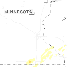
Minnesota
| Local Time | Report Details |
|---|---|
| 8:05 AM CDT | Numerous trees and power lines were down throughout the city of alde in freeborn county MN, 40.9 miles NNW of Mason City, IA |
| 8:50 AM CDT | Power lines down across i90 eastbound near alden... m in freeborn county MN, 40.6 miles NNW of Mason City, IA |
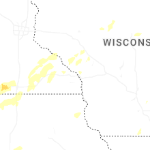
Wisconsin
| Local Time | Report Details |
|---|---|
| 12:03 PM CDT | Reported trees down near westb in vernon county WI, 23.2 miles ESE of La Crosse, WI |
| 12:27 PM CDT | Reported trees and powerlines down in the town of glendal in monroe county WI, 45.2 miles E of La Crosse, WI |
| 1:28 PM CDT | Trees down. the time of this report is an estimate based on rada in waushara county WI, 69 miles N of Madison, WI |
| 1:32 PM CDT | Trees down. the time of this report is an estimate based on rada in waushara county WI, 65.6 miles WSW of Green Bay, WI |
| 1:45 PM CDT | Tree branches dow in waupaca county WI, 53.3 miles WSW of Green Bay, WI |
| 1:45 PM CDT | Powerlines dow in waupaca county WI, 54.5 miles W of Green Bay, WI |
| 1:59 PM CDT | Lots of branches down... some larg in waupaca county WI, 44.6 miles W of Green Bay, WI |
| 2:15 PM CDT | Trees and powerlines down in bear cree in outagamie county WI, 35.1 miles W of Green Bay, WI |
| 2:16 PM CDT | Relayed from wluk from the public road was blocked off due to tree on powerlines dow in brown county WI, 4 miles WSW of Green Bay, WI |
| 2:21 PM CDT | Trees and powerlines down in shiocto in outagamie county WI, 28.6 miles W of Green Bay, WI |
| 2:37 PM CDT | Thunderstorm winds collapsed a standing barn. the time of this report is an estimate based on radar dat in calumet county WI, 24.2 miles SSW of Green Bay, WI |
| 2:47 PM CDT | Large tree snapped in hal in brown county WI, 15.2 miles SSW of Green Bay, WI |
| 2:51 PM CDT | Large branch over roa in brown county WI, 7 miles W of Green Bay, WI |
| 2:55 PM CDT | Trees and power lines dow in brown county WI, 3.7 miles SW of Green Bay, WI |
| 2:55 PM CDT | Tree down. time estimated from rada in kewaunee county WI, 16.1 miles ESE of Green Bay, WI |
| 2:57 PM CDT | Tree dow in kewaunee county WI, 20.8 miles ESE of Green Bay, WI |
| 3:00 PM CDT | Power line and tree dow in kewaunee county WI, 25.5 miles E of Green Bay, WI |
| 3:00 PM CDT | Trees and power lines dow in brown county WI, 0.5 miles ESE of Green Bay, WI |
| 3:27 PM CDT | Power line and tree down at 912 division s in kewaunee county WI, 28.8 miles ENE of Green Bay, WI |
| 3:45 PM CDT | Trees dow in door county WI, 51.7 miles NE of Green Bay, WI |
| 3:46 PM CDT | Tree down blocking highway 5 in door county WI, 51.2 miles NE of Green Bay, WI |
| 3:51 PM CDT | Tree down on propane tank. report forwarded from ham operator. time estimated from rada in door county WI, 58.6 miles NE of Green Bay, WI |
| 3:52 PM CDT | Hwy 42 from egg harbor to fish creek impassable do to trees down and power line in door county WI, 53.3 miles NE of Green Bay, WI |
| 3:55 PM CDT | Trees dow in door county WI, 60.7 miles NE of Green Bay, WI |
| 3:56 PM CDT | Hwy 42 from fish creek to ephraim impassable do to trees down and power line in door county WI, 58 miles NE of Green Bay, WI |
| 5:00 PM CDT | Menomonee falls pd reports multiple large branches and a few 7 to 8 inch diameter trees down... with at least one of those toppling some power line in waukesha county WI, 64.5 miles E of Madison, WI |
Colorado
| Local Time | Report Details |
|---|---|
| 2:37 PM MDT | Quarter sized hail reported near Agate, CO, 65.4 miles ESE of Denver, CO, report from mping: quarter (1.00 in.). |
| 2:40 PM MDT | Quarter sized hail reported near Agate, CO, 61.3 miles ESE of Denver, CO, measured with digital calipers. |
| 3:07 PM MDT | Quarter sized hail reported near Matheson, CO, 68.3 miles ESE of Denver, CO, report from mping: quarter (1.00 in.). |
| 3:18 PM MDT | Storm damage reported in logan county CO, 46 miles NW of Yuma, CO |
| 3:26 PM MDT | Quarter sized hail reported near Limon, CO, 69.7 miles ESE of Denver, CO, report via spotternetwork. |
| 3:41 PM MDT | Quarter sized hail reported near Limon, CO, 75.3 miles ESE of Denver, CO |
| 3:59 PM MDT | Golf Ball sized hail reported near Matheson, CO, 69.4 miles ESE of Denver, CO, report from mping: golf ball (1.75 in.). |
| 4:01 PM MDT | Ping Pong Ball sized hail reported near Limon, CO, 73.3 miles ESE of Denver, CO, report from mping: ping pong ball (1.50 in.). |
| 4:04 PM MDT | Hen Egg sized hail reported near Matheson, CO, 69.4 miles ESE of Denver, CO, report from mping: hen egg (2.00 in.). |
| 4:08 PM MDT | Quarter sized hail reported near Limon, CO, 73.9 miles ESE of Denver, CO, report from mping: quarter (1.00 in.). |
| 4:09 PM MDT | Hen Egg sized hail reported near Limon, CO, 73.3 miles ESE of Denver, CO, report from mping: hen egg (2.00 in.). |
| 4:11 PM MDT | Ping Pong Ball sized hail reported near Limon, CO, 73.9 miles ESE of Denver, CO, report from mping: ping pong ball (1.50 in.). |
| 4:16 PM MDT | Ping Pong Ball sized hail reported near Limon, CO, 74.5 miles ESE of Denver, CO, report from mping: ping pong ball (1.50 in.). |
| 4:18 PM MDT | Hen Egg sized hail reported near Limon, CO, 75.4 miles ESE of Denver, CO |
| 4:20 PM MDT | Tennis Ball sized hail reported near Matheson, CO, 73.5 miles ESE of Denver, CO |
| 4:24 PM MDT | Baseball sized hail reported near Limon, CO, 76.7 miles ESE of Denver, CO |
| 4:27 PM MDT | Tennis Ball sized hail reported near Limon, CO, 75.7 miles NE of Pueblo, CO, report from mping: tennis ball (2.50 in.). |
| 4:28 PM MDT | Tea Cup sized hail reported near Limon, CO, 77.2 miles ESE of Denver, CO |
| 4:28 PM MDT | Baseball sized hail reported near Limon, CO, 76.1 miles NE of Pueblo, CO, report from mping: baseball (2.75 in.). |
| 4:32 PM MDT | Hen Egg sized hail reported near Limon, CO, 77.5 miles NE of Pueblo, CO, report from mping: hen egg (2.00 in.). time estimated by radar. |
| 4:44 PM MDT | Hen Egg sized hail reported near Yuma, CO, 10.5 miles N of Yuma, CO, 2 inch hail reported via spotter network. |
| 4:49 PM MDT | Tennis Ball sized hail reported near Hugo, CO, 77.6 miles NE of Pueblo, CO, report from mping: tennis ball (2.50 in.). |
| 4:59 PM MDT | Quarter sized hail reported near Brush, CO, 51.1 miles WNW of Yuma, CO, report from mping: quarter (1.00 in.). |
| 5:03 PM MDT | Ping Pong Ball sized hail reported near Brush, CO, 50 miles WNW of Yuma, CO |
| 5:08 PM MDT | Quarter sized hail reported near Hugo, CO, 81.3 miles NE of Pueblo, CO, report from mping: quarter (1.00 in.). |
| 5:11 PM MDT | Ping Pong Ball sized hail reported near Hugo, CO, 80.4 miles NE of Pueblo, CO, report from mping: ping pong ball (1.50 in.). |
| 5:12 PM MDT | Golf Ball sized hail reported near Hugo, CO, 78.8 miles NE of Pueblo, CO, report from mping: golf ball (1.75 in.). |
| 5:13 PM MDT | Golf Ball sized hail reported near Hugo, CO, 79.2 miles NE of Pueblo, CO, report from mping: golf ball (1.75 in.). |
| 5:14 PM MDT | Hen Egg sized hail reported near Hugo, CO, 80.4 miles NE of Pueblo, CO, report from mping: hen egg (2.00 in.). |
| 5:16 PM MDT | Golf Ball sized hail reported near Hugo, CO, 80.4 miles NE of Pueblo, CO, report from mping: golf ball (1.75 in.). time estimated by radar. |
| 5:16 PM MDT | Tennis Ball sized hail reported near Hugo, CO, 80 miles NE of Pueblo, CO, report from mping: tennis ball (2.50 in.). |
| 5:20 PM MDT | Hen Egg sized hail reported near Eckley, CO, 15.7 miles NE of Yuma, CO, delayed report via social media. measured 2.25 inch hail fell at the approximate report time. time estimated via radar. |
| 5:24 PM MDT | Half Dollar sized hail reported near Yuma, CO, 15.3 miles N of Yuma, CO, trained spotter reported half dollar 30 minutes after storm. |
| 5:40 PM MDT | Golf Ball sized hail reported near Wray, CO, 17.2 miles ESE of Yuma, CO |
| 6:00 PM MDT | Golf Ball sized hail reported near Wray, CO, 26.8 miles ESE of Yuma, CO, trained spotter actively getting golf ball sized hail. |
| 6:01 PM MDT | Tea Cup sized hail reported near Hugo, CO, 67.9 miles NE of Pueblo, CO, report via spotternetwork. |
| 6:13 PM MDT | Golf Ball sized hail reported near Hugo, CO, 67.6 miles NE of Pueblo, CO, report from mping: golf ball (1.75 in.). |
| 6:13 PM MDT | Baseball sized hail reported near Hugo, CO, 68.5 miles NE of Pueblo, CO, report from mping: baseball (2.75 in.). |
| 6:20 PM MDT | Half Dollar sized hail reported near Karval, CO, 71.2 miles NE of Pueblo, CO, report from mping: half dollar (1.25 in.). |
| 6:28 PM MDT | Hen Egg sized hail reported near Hugo, CO, 69.9 miles NE of Pueblo, CO, report from mping: hen egg (2.00 in.). |
| 6:30 PM MDT | Hen Egg sized hail reported near Karval, CO, 71.2 miles NE of Pueblo, CO |
| 6:32 PM MDT | Tennis Ball sized hail reported near Karval, CO, 71.2 miles NE of Pueblo, CO, report via spotternetwork. |
| 6:48 PM MDT | Tea Cup sized hail reported near Karval, CO, 73.4 miles ENE of Pueblo, CO, report via spotternetwork. |
| 6:50 PM MDT | Tennis Ball sized hail reported near Karval, CO, 73.1 miles ENE of Pueblo, CO, report from mping: tennis ball (2.50 in.). |
| 6:56 PM MDT | Tea Cup sized hail reported near Karval, CO, 74.5 miles ENE of Pueblo, CO, report via spotternetwork. time estimated by radar. |
| 6:58 PM MDT | Grapefruit sized hail reported near Karval, CO, 75 miles ENE of Pueblo, CO, report via spotternetwork. time estimated by radar. |
| 7:07 PM MDT | Quarter sized hail reported near Yuma, CO, 18.6 miles S of Yuma, CO, trained spotter reported pea to 1 inch hail and hail is starting to accumulate. |
| 7:30 PM MDT | Tennis Ball sized hail reported near Karval, CO, 71.3 miles ENE of Pueblo, CO, several reports of tennis ball sized hail from storm chasers at county road 109 and county road w north of karval. time estimated by radar. |
| 7:36 PM MDT | Quarter sized hail reported near Calhan, CO, 50.6 miles NNE of Pueblo, CO |
| 7:37 PM MDT | Quarter sized hail reported near Hugo, CO, 72.5 miles NE of Pueblo, CO, report from mping: quarter (1.00 in.). |
| 7:42 PM MDT | Golf Ball sized hail reported near Rush, CO, 61.8 miles NE of Pueblo, CO |
| 7:48 PM MDT | Ping Pong Ball sized hail reported near Hugo, CO, 63.8 miles NE of Pueblo, CO, report from mping: ping pong ball (1.50 in.). |
| 8:33 PM MDT | Half Dollar sized hail reported near Rush, CO, 56.9 miles NE of Pueblo, CO, report from mping: half dollar (1.25 in.). |
| 8:45 PM MDT | Tea Cup sized hail reported near Rush, CO, 50.6 miles NE of Pueblo, CO, report via spotternetwork. |
| 9:05 PM MDT | Tea Cup sized hail reported near Ordway, CO, 53 miles ENE of Pueblo, CO, measured with calipers... photo provided via social media. |
| 10:45 PM MDT | Quarter sized hail reported near Pueblo, CO, 9.2 miles WNW of Pueblo, CO |
| 10:55 PM MDT | Half Dollar sized hail reported near Pueblo, CO, 8.8 miles WNW of Pueblo, CO |
| 11:10 PM MDT | Quarter sized hail reported near Pueblo, CO, 5.1 miles ENE of Pueblo, CO |
| 11:19 PM MDT | Golf Ball sized hail reported near Pueblo, CO, 6.7 miles E of Pueblo, CO, report from mping: golf ball (1.75 in.). |
| 11:20 PM MDT | Ping Pong Ball sized hail reported near Pueblo, CO, 6.2 miles E of Pueblo, CO, report from mping: ping pong ball (1.50 in.). |
| 11:55 PM MDT | Mesonet station hly02 holly no. in prowers county CO, 75.5 miles W of Garden City, KS |
| 11:59 PM MDT | Measured by a storm chase in prowers county CO, 80.7 miles WNW of Garden City, KS |
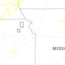
Missouri
| Local Time | Report Details |
|---|---|
| 5:21 PM CDT | Delayed social media video of winds to at least 60 mph with several limbs blown down at a residence. time estimated from rada in macon county MO, 65.3 miles NNW of Columbia, MO |
| 5:26 PM CDT | Delayed social media report of downed tree limbs at a residence near route tt. time estimated from rada in macon county MO, 65.5 miles NNW of Columbia, MO |
| 5:39 PM CDT | Multiple reports of power lines down and several power outages south and southeast of elmer. time based on dispatch reports and confirmed from rada in macon county MO, 59.7 miles SW of Kahoka, MO |
| 5:48 PM CDT | Delayed report. several large trees were blown down. time estimated from radar. report via social medi in macon county MO, 55.1 miles SW of Kahoka, MO |
| 6:00 PM CDT | Quarter sized hail reported near Atlanta, MO, 50.5 miles SW of Kahoka, MO, delayed report from social media. time estimated from radar. |
| 6:20 PM CDT | E911 reported 4-inch branches down between leonard and hwy j just east of hwy in shelby county MO, 44 miles SSW of Kahoka, MO |
| 6:30 PM CDT | Backyard anemometer recorded 58 mph. minor tree damage reported. time estimate in shelby county MO, 40.6 miles SSW of Kahoka, MO |
| 7:20 PM CDT | Marion county ambulance at highway 6 / highway v... maywood in marion county had to pull over due to estimated 70+ mph winds... zero visibility... and trees with a heav in marion county MO, 33.7 miles S of Kahoka, MO |
| 7:34 PM CDT | 60 mph winds estimated on the west side of quinc in marion county MO, 37 miles SSE of Kahoka, MO |
Illinois
| Local Time | Report Details |
|---|---|
| 7:34 PM CDT | Adams county spotter reported 65 mph wind gus in adams county IL, 35.8 miles SSE of Kahoka, MO |
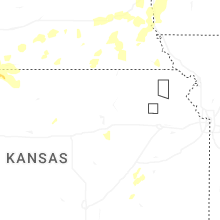
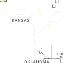
Kansas
| Local Time | Report Details |
|---|---|
| 8:04 PM CDT | Awos station ksyf st. francis cit in cheyenne county KS, 47.8 miles WNW of Colby, KS |
| 8:08 PM CDT | Storm damage reported in cheyenne county KS, 38.8 miles NW of Colby, KS |
| 7:30 PM MDT | Nws employee reports 65 mph gus in sherman county KS, 21.8 miles WNW of Colby, KS |
| 10:24 PM CDT | Storm damage reported in norton county KS, 77.8 miles NNW of Hays, KS |
| 10:38 PM CDT | Storm damage reported in phillips county KS, 71.6 miles N of Hays, KS |
| 10:44 PM CDT | Storm damage reported in phillips county KS, 72.7 miles N of Hays, KS |
| 11:08 PM CDT | Storm damage reported in phillips county KS, 60 miles N of Hays, KS |
| 11:55 PM CDT | Storm damage reported in smith county KS, 72 miles SSW of Grand Island, NE |
| 11:55 PM CDT | Storm damage reported in smith county KS, 67.9 miles NNE of Hays, KS |
| 12:15 AM CDT | Storm damage reported in russell county KS, 27.6 miles E of Hays, KS |
| 12:20 AM CDT | Storm damage reported in mitchell county KS, 71.9 miles ENE of Hays, KS |
| 12:20 AM CDT | Davis weather statio in jewell county KS, 68.3 miles S of Grand Island, NE |
| 12:20 AM CDT | Kansas mesone in russell county KS, 36.3 miles E of Hays, KS |
| 12:22 AM CDT | Storm damage reported in jewell county KS, 82.1 miles NE of Hays, KS |
| 12:32 AM CDT | Storm damage reported in jewell county KS, 84.1 miles NE of Hays, KS |
| 12:33 AM CDT | Storm damage reported in jewell county KS, 85.8 miles WNW of Manhattan, KS |
| 12:39 AM CDT | Outflow from the thunderstor in lincoln county KS, 64.7 miles E of Hays, KS |
| 12:49 AM CDT | Storm damage reported in republic county KS, 73.9 miles NW of Manhattan, KS |
| 12:53 AM CDT | Public weather statio in republic county KS, 69.9 miles SSE of Grand Island, NE |
| 12:58 AM CDT | Storm damage reported in cloud county KS, 63.7 miles WNW of Manhattan, KS |
| 1:32 AM CDT | Storm damage reported in washington county KS, 49.3 miles NNW of Manhattan, KS |
| 12:35 AM MDT | Awos station k3k3 syracus in hamilton county KS, 47.9 miles W of Garden City, KS |
| 1:35 AM CDT | Storm damage reported in saline county KS, 64.4 miles WSW of Manhattan, KS |
| 1:35 AM CDT | Storm damage reported in saline county KS, 64.4 miles WSW of Manhattan, KS |
| 1:42 AM CDT | Public weather statio in washington county KS, 40 miles NNW of Manhattan, KS |
| 2:55 AM CDT | Pws hineman farms - kksdight2 in lane county KS, 39.2 miles NE of Garden City, KS |
| 3:59 AM CDT | Pws - kksellis4 in ellis county KS, 12.9 miles W of Hays, KS |
| 4:04 AM CDT | Pws station kkspalco3 in rooks county KS, 24.3 miles NNW of Hays, KS |
| 4:04 AM CDT | Mesonet station up856 0.8 e yocemento (upr in ellis county KS, 5 miles WNW of Hays, KS |
| 4:15 AM CDT | Awos station khys hays regional airport awos sit in ellis county KS, 3.7 miles ESE of Hays, KS |
| 4:28 AM CDT | Storm damage reported in russell county KS, 21.1 miles ENE of Hays, KS |
| 4:34 AM CDT | Davis weather statio in rooks county KS, 38.7 miles N of Hays, KS |
| 4:50 AM CDT | Wind gust was reported by kansas mesone in russell county KS, 35.8 miles E of Hays, KS |
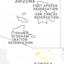
Arizona
| Local Time | Report Details |
|---|---|
| 7:45 PM MST | Personal weather station recorded gust of 60 mp in cochise county AZ, 48.3 miles N of Douglas, AZ |
Connect with Interactive Hail Maps