

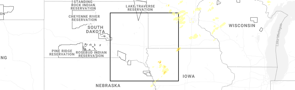
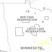
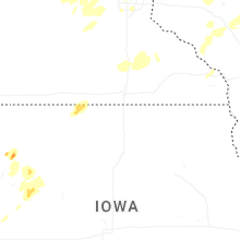
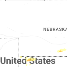
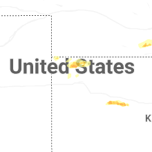
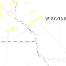
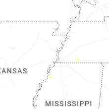
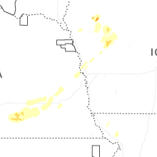
Hail Map for Friday, August 8, 2025
Number of Impacted Households on 8/8/2025
0
Impacted by 1" or Larger Hail
0
Impacted by 1.75" or Larger Hail
0
Impacted by 2.5" or Larger Hail
Square Miles of Populated Area Impacted on 8/8/2025
0
Impacted by 1" or Larger Hail
0
Impacted by 1.75" or Larger Hail
0
Impacted by 2.5" or Larger Hail
Cities Most Affected by Hail Storms of 8/8/2025
| Hail Size | Demographics of Zip Codes Affected | ||||||
|---|---|---|---|---|---|---|---|
| City | Count | Average | Largest | Pop Density | House Value | Income | Age |
| Cherokee, IA | 1 | 2.00 | 2.00 | 43 | $57k | $33.4k | 47.1 |
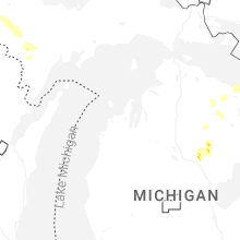
| West Branch, MI | 1 | 1.75 | 1.75 | 44 | $85k | $34.6k | 45.7 |
| Rose City, MI | 1 | 1.75 | 1.75 | 23 | $66k | $30.2k | 49.1 |
Hail and Wind Damage Spotted on 8/8/2025
Filter by Report Type:Hail ReportsWind Reports
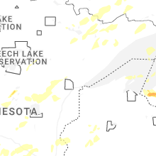
Minnesota
| Local Time | Report Details |
|---|---|
| 8:24 AM CDT | Trees down on turtle lake from facebook messag in crow wing county MN, 87.8 miles WSW of Duluth, MN |
| 8:50 AM CDT | Report of medium tree down partially across highway 47. time estimated from rada in aitkin county MN, 71.3 miles WSW of Duluth, MN |
| 9:00 AM CDT | Large tree down. estimated 12 inch diameter. barn roof damage in aitkin county MN, 61.1 miles W of Duluth, MN |
| 9:00 AM CDT | Numerous trees down in the vicinity of mn 65 and 450th st. north of mcgregor. time estimated by rada in aitkin county MN, 58.5 miles W of Duluth, MN |
| 9:10 AM CDT | Several trees on powerlines and several trees across cr6 near round lak in aitkin county MN, 52 miles W of Duluth, MN |
| 9:10 AM CDT | Large oak tree snapped 4 to 6 feet from base. time estimated from radar and observe in aitkin county MN, 63.2 miles W of Duluth, MN |
| 9:20 AM CDT | Tree damage 6 to 12 inch diameter. spruce tree on graff roa in st. louis county MN, 45.1 miles W of Duluth, MN |
| 9:20 AM CDT | Around twelve 6 to 12 inch trees down on the east side of rasmussen road south of prairie river. most trees fell to the north east. time estimated from rada in st. louis county MN, 44.6 miles W of Duluth, MN |
| 9:23 AM CDT | 18 inch diameter spruce tree blown down. moen rd. tree top on road. time estimated by rada in st. louis county MN, 39.9 miles W of Duluth, MN |
| 9:35 AM CDT | Tree branches down and tree downed powerline on near by residents dec in st. louis county MN, 39.5 miles WNW of Duluth, MN |
| 9:35 AM CDT | A few trees down on parking lot. poplar tree tops snappe in st. louis county MN, 40.1 miles WNW of Duluth, MN |
| 9:40 AM CDT | Tree on powerline both are down and across hwy in st. louis county MN, 38.1 miles WNW of Duluth, MN |
| 9:40 AM CDT | Tree down on hwy 73 near mile marker 4 in st. louis county MN, 39.7 miles WNW of Duluth, MN |
| 10:56 AM CDT | Tree across road... timing based on rada in st. louis county MN, 61.1 miles N of Duluth, MN |
| 10:10 PM CDT | Quarter sized hail reported near Sauk Centre, MN, 65.8 miles NE of Montevideo, MN |
| 2:25 AM CDT | Quarter sized hail reported near Cokato, MN, 46.3 miles W of Minneapolis, MN |
North Dakota
| Local Time | Report Details |
|---|---|
| 1:16 PM CDT | 5 inch diameter cottonwood tree snapped at the base from last nights storm in burleigh county ND, 2.4 miles S of Bismarck, ND |
Michigan
| Local Time | Report Details |
|---|---|
| 7:05 PM EDT | Golf Ball sized hail reported near Rose City, MI, 55.4 miles SW of Alpena, MI, time estimated by radar. |
| 8:18 PM EDT | Trained spotter reports large tree down on west clear lake road just off of fairview road... via social media post. time estimated by rada in ogemaw county MI, 62.5 miles SW of Alpena, MI |
| 8:20 PM EDT | Golf Ball sized hail reported near West Branch, MI, 61.4 miles SW of Alpena, MI |
| 8:25 PM EDT | Ping Pong Ball sized hail reported near West Branch, MI, 61.4 miles SW of Alpena, MI |
Oklahoma
| Local Time | Report Details |
|---|---|
| 6:35 PM CDT | A decaying thunderstorm produced a minor heat burst over hooker. temperature increased and dew point decreased in conjunction with the severe wind gus in texas county OK, 79 miles SSW of Garden City, KS |
| 8:45 PM CDT | Likely downburst produced peak gust of 59 mp in texas county OK, 87.9 miles SW of Garden City, KS |
| 12:35 AM CDT | Winds due to heat burs in beaver county OK, 67.8 miles WNW of Woodward, OK |
| 1:50 AM CDT | Winds due to heat burs in beaver county OK, 49.3 miles WNW of Woodward, OK |
Kansas
| Local Time | Report Details |
|---|---|
| 10:31 PM CDT | Heat burst winds at awos station klbl libera in seward county KS, 65 miles S of Garden City, KS |
| 10:36 PM CDT | Heat burst winds mesonet station ur350 kismw in seward county KS, 56.9 miles S of Garden City, KS |
| 9:40 PM MDT | Quarter sized hail reported near Brewster, KS, 21.8 miles WNW of Colby, KS, off-duty nws employee reported quarter sized hail ongoing. |
Nebraska
| Local Time | Report Details |
|---|---|
| 1:47 AM CDT | Gust reported on awos voice line. time estimated from rada in phelps county NE, 61.9 miles WSW of Grand Island, NE |
| 1:55 AM CDT | Awos station khde holdrege airpor in phelps county NE, 61 miles WSW of Grand Island, NE |
| 2:15 AM CDT | Via personal weather statio in kearney county NE, 43.8 miles WSW of Grand Island, NE |
| 2:46 AM CDT | Via personal weather statio in webster county NE, 44.7 miles SSW of Grand Island, NE |
| 2:53 AM CDT | Wind gusts at least 50-60 mph. also have pea size hai in webster county NE, 43.9 miles SSW of Grand Island, NE |
| 3:25 AM CDT | Multiple reports of 50-60 mph wind gusts and pea size hail from glenvil area spotter in clay county NE, 41 miles SSE of Grand Island, NE |
| 3:25 AM CDT | Multiple reports of 50-60 mph wind gusts and pea size hail from fairfield area spotter in clay county NE, 36.2 miles SSE of Grand Island, NE |
| 3:25 AM CDT | Multiple reports of 50-60 mph wind gusts and pea size hail from glenvil area spotter in clay county NE, 29.7 miles S of Grand Island, NE |
| 3:28 AM CDT | Mesonet station up021 fairfield 2.1w (upr in clay county NE, 34.4 miles SSE of Grand Island, NE |
| 3:34 AM CDT | Quarter sized hail reported near Fairfield, NE, 36.2 miles SSE of Grand Island, NE |
| 3:34 AM CDT | Storm damage reported in clay county NE, 42.9 miles SSE of Grand Island, NE |
| 3:36 AM CDT | Via personal weather statio in clay county NE, 32.9 miles SSE of Grand Island, NE |
| 3:37 AM CDT | Storm damage reported in clay county NE, 31.8 miles SSE of Grand Island, NE |
| 3:38 AM CDT | Davis weather statio in clay county NE, 34.6 miles SSE of Grand Island, NE |
| 3:42 AM CDT | Storm damage reported in clay county NE, 34.9 miles SE of Grand Island, NE |
| 3:46 AM CDT | 50 to 60 mph winds and dime size hail... very heavy rai in clay county NE, 36.1 miles SE of Grand Island, NE |
| 3:49 AM CDT | Quarter sized hail reported near Clay Center, NE, 34.9 miles SE of Grand Island, NE |
| 3:49 AM CDT | Via personal weather statio in thayer county NE, 54.3 miles SE of Grand Island, NE |
| 3:49 AM CDT | Via personal weather statio in fillmore county NE, 44.4 miles SE of Grand Island, NE |
| 3:52 AM CDT | Ambient weather statio in clay county NE, 33.7 miles SE of Grand Island, NE |
| 3:53 AM CDT | Davis weather statio in fillmore county NE, 37 miles SE of Grand Island, NE |
| 3:58 AM CDT | Via personal weather statio in fillmore county NE, 55 miles SE of Grand Island, NE |
| 4:04 AM CDT | Power out in shickley area per e in fillmore county NE, 47.7 miles SE of Grand Island, NE |
| 4:05 AM CDT | Davis weather statio in fillmore county NE, 36.5 miles SE of Grand Island, NE |
| 4:05 AM CDT | Via personal weather statio in fillmore county NE, 43.2 miles SE of Grand Island, NE |
| 4:08 AM CDT | Reports of large tree limbs down and power out in grafto in fillmore county NE, 38.8 miles ESE of Grand Island, NE |
| 4:11 AM CDT | Power outages in fairmon in fillmore county NE, 44.7 miles ESE of Grand Island, NE |
| 4:11 AM CDT | Davis weather statio in fillmore county NE, 47.9 miles ESE of Grand Island, NE |
| 4:12 AM CDT | Via davis weatherlink personal weather station. observation is appears to be supported by area damage reports and by rada in fillmore county NE, 46.5 miles ESE of Grand Island, NE |
| 4:14 AM CDT | Via personal weather station. gust measured on the leading edge of the stor in fillmore county NE, 45.7 miles ESE of Grand Island, NE |
| 4:25 AM CDT | Power outages reported in exeter are in fillmore county NE, 50.4 miles ESE of Grand Island, NE |
| 4:25 AM CDT | Gust measured from a public weather statio in saline county NE, 59.3 miles ESE of Grand Island, NE |
| 4:25 AM CDT | Emergency manager reports trees down... power outages in friend... with an estimated 80-90 mph wind spee in saline county NE, 58.7 miles ESE of Grand Island, NE |
| 4:25 AM CDT | Delayed emergency manager report of measured wind gusts up to 84 mph. time estimated from rada in saline county NE, 58.2 miles ESE of Grand Island, NE |
| 4:26 AM CDT | Davis weather statio in fillmore county NE, 51.3 miles ESE of Grand Island, NE |
| 4:30 AM CDT | Davis weather statio in fillmore county NE, 51.5 miles ESE of Grand Island, NE |
| 4:32 AM CDT | Davis weather statio in fillmore county NE, 55 miles ESE of Grand Island, NE |
| 4:32 AM CDT | Measured by public weather statio in saline county NE, 70 miles ESE of Grand Island, NE |
| 4:35 AM CDT | Measured by public weather statio in seward county NE, 59.7 miles ESE of Grand Island, NE |
| 4:40 AM CDT | Large tree down around the intersection of 8th or 9th street and grove ave. time estimated from rada in saline county NE, 68.9 miles SW of Omaha, NE |
| 4:45 AM CDT | Measured by public weather statio in seward county NE, 67.9 miles WSW of Omaha, NE |
| 4:50 AM CDT | Measured by public weather statio in lancaster county NE, 54.8 miles SW of Omaha, NE |
| 4:50 AM CDT | Measured by public weather statio in seward county NE, 65.1 miles WSW of Omaha, NE |
| 4:53 AM CDT | Measured by public weather statio in seward county NE, 64.5 miles E of Grand Island, NE |
| 4:53 AM CDT | Power outages in tow in seward county NE, 59 miles E of Grand Island, NE |
| 4:54 AM CDT | Asos station klnk lincoln airpor in lancaster county NE, 51.8 miles WSW of Omaha, NE |
| 4:54 AM CDT | Measured by public weather statio in seward county NE, 62.3 miles E of Grand Island, NE |
| 4:55 AM CDT | Delayed report of large trees down and a roof torn off a shed. time estimated from rada in seward county NE, 61 miles WSW of Omaha, NE |
| 4:56 AM CDT | Measured by public weather statio in lancaster county NE, 60.6 miles SW of Omaha, NE |
| 4:56 AM CDT | Measured by public weather statio in lancaster county NE, 60.6 miles SW of Omaha, NE |
| 4:57 AM CDT | Measured by public weather statio in lancaster county NE, 50.8 miles SW of Omaha, NE |
| 5:01 AM CDT | Measured by public weather statio in seward county NE, 63.8 miles WSW of Omaha, NE |
| 5:07 AM CDT | Trained spotter reported wind gusts estimated up to 80 mph and extensive tree damage. time estimated from rada in lancaster county NE, 53.2 miles WSW of Omaha, NE |
| 5:08 AM CDT | Asos station klnk lincoln airpor in lancaster county NE, 51.8 miles WSW of Omaha, NE |
| 5:12 AM CDT | Asos station klnk lincoln airpor in lancaster county NE, 51.8 miles WSW of Omaha, NE |
| 5:15 AM CDT | Measured by public weather statio in lancaster county NE, 52.4 miles WSW of Omaha, NE |
| 5:16 AM CDT | Measured by public weather statio in lancaster county NE, 53.4 miles SW of Omaha, NE |
| 5:19 AM CDT | Measured by public weather statio in lancaster county NE, 46 miles WSW of Omaha, NE |
| 5:20 AM CDT | Measured by public weather statio in lancaster county NE, 47.6 miles SW of Omaha, NE |
| 5:20 AM CDT | Measured by public weather statio in lancaster county NE, 47.2 miles WSW of Omaha, NE |
| 5:21 AM CDT | Measured by public weather station near 27th and pine lake roa in lancaster county NE, 53.2 miles SW of Omaha, NE |
| 5:22 AM CDT | Asos station klnk lincoln airpor in lancaster county NE, 51.8 miles WSW of Omaha, NE |
| 5:22 AM CDT | Measured by public weather station. appears justified based on upstream reports near lincol in lancaster county NE, 45.9 miles WSW of Omaha, NE |
| 5:23 AM CDT | Storm damage reported in cass county NE, 33.3 miles SW of Omaha, NE |
| 5:23 AM CDT | Measured by public weather statio in lancaster county NE, 52.5 miles WSW of Omaha, NE |
| 5:28 AM CDT | Measured by public weather statio in lancaster county NE, 34.3 miles WSW of Omaha, NE |
| 5:28 AM CDT | Delayed report. time estimated with rada in lancaster county NE, 51.7 miles WSW of Omaha, NE |
| 5:29 AM CDT | Measured by public weather statio in cass county NE, 35.4 miles SW of Omaha, NE |
| 5:35 AM CDT | Measured by public weather statio in saunders county NE, 38.6 miles W of Omaha, NE |
| 5:41 AM CDT | Measured by public weather statio in saunders county NE, 24.4 miles WSW of Omaha, NE |
| 5:44 AM CDT | Measured by public weather statio in saunders county NE, 23 miles WSW of Omaha, NE |
| 5:45 AM CDT | Measured by public weather statio in saunders county NE, 28.1 miles WSW of Omaha, NE |
| 5:49 AM CDT | Measured by public weather station. near 204th and q s in douglas county NE, 15.7 miles WSW of Omaha, NE |
| 5:50 AM CDT | Measured by public weather statio in washington county NE, 17.8 miles NW of Omaha, NE |
| 5:52 AM CDT | Measured by public weather statio in sarpy county NE, 15 miles WSW of Omaha, NE |
| 5:54 AM CDT | Storm damage reported in douglas county NE, 16.8 miles WSW of Omaha, NE |
| 5:54 AM CDT | Off duty nws employee. possibly highe in douglas county NE, 16.7 miles WSW of Omaha, NE |
| 5:55 AM CDT | Awos station kmle millard airpor in douglas county NE, 10.2 miles WSW of Omaha, NE |
| 5:56 AM CDT | Personal weather station measured gus in douglas county NE, 15.2 miles WSW of Omaha, NE |
| 5:57 AM CDT | Measured by public weather station near 192nd and harriso in sarpy county NE, 14.9 miles WSW of Omaha, NE |
| 5:59 AM CDT | Measured by a public weather station near 132nd and west mapl in douglas county NE, 9.6 miles WNW of Omaha, NE |
| 6:00 AM CDT | Power outages reported by off duty nws employe in douglas county NE, 16.7 miles WSW of Omaha, NE |
| 6:00 AM CDT | Measured by public weather station near 168th and fort s in douglas county NE, 12.4 miles WNW of Omaha, NE |
| 6:01 AM CDT | Measured by public weather statio in douglas county NE, 16.3 miles WNW of Omaha, NE |
| 6:03 AM CDT | Storm damage reported in douglas county NE, 22.7 miles W of Omaha, NE |
| 6:04 AM CDT | Retired meteorologist reports peak gust of 83 mph on home weather statio in douglas county NE, 7.5 miles WNW of Omaha, NE |
| 6:04 AM CDT | Power outages reported in boys tow in douglas county NE, 9.9 miles W of Omaha, NE |
| 6:06 AM CDT | Measured by public weather statio in douglas county NE, 20.9 miles W of Omaha, NE |
| 6:08 AM CDT | Measured by public weather station just east of the north omaha airpor in douglas county NE, 8.2 miles NNW of Omaha, NE |
| 6:11 AM CDT | Measured by a personal weather station near 114th and stat in douglas county NE, 9.1 miles WNW of Omaha, NE |
| 6:14 AM CDT | Measured by a public weather statio in washington county NE, 26.5 miles NW of Omaha, NE |
| 6:15 AM CDT | First observation with severe wind at awos station kbta blair mun in washington county NE, 14.4 miles NW of Omaha, NE |
| 6:16 AM CDT | Measured by a public weather station near 168th and bennington rd. multiple other stations in close proximity measured gusts in the 60 in douglas county NE, 14.2 miles WNW of Omaha, NE |
| 6:20 AM CDT | Measured by a public weather station near 156th and state s in douglas county NE, 12.7 miles WNW of Omaha, NE |
| 6:20 AM CDT | Measured by a personal weather statio in washington county NE, 17.5 miles NW of Omaha, NE |
| 6:22 AM CDT | Measured by a personal weather statio in washington county NE, 21.5 miles NNW of Omaha, NE |
| 6:24 AM CDT | Measured by a public weather statio in washington county NE, 21 miles NNW of Omaha, NE |
| 6:35 AM CDT | Asos station ktqe tekamah airpor in burt county NE, 37.3 miles NNW of Omaha, NE |
Iowa
| Local Time | Report Details |
|---|---|
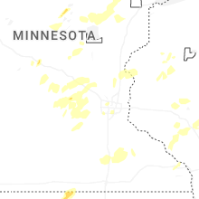
| 3:38 AM CDT | Hen Egg sized hail reported near Cherokee, IA, 19.1 miles WNW of Storm Lake, IA, social media report: multiple pictures of golf ball to hen egg sized hail shown in cherokee. time was estimated via radar. |
| 6:22 AM CDT | Measured at the missouri valley airpor in harrison county IA, 19.5 miles N of Omaha, NE |
| 6:23 AM CDT | Measured by a personal weather statio in harrison county IA, 20.1 miles N of Omaha, NE |
| 6:35 AM CDT | Measured by a public weather statio in harrison county IA, 27.6 miles NNE of Omaha, NE |
| 6:43 AM CDT | Measured by two public weather stations in missouri valle in harrison county IA, 20.1 miles N of Omaha, NE |
| 11:45 AM UTC | Measured by a public weather statio in monona county IA, 44.2 miles N of Omaha, NE |
Missouri
| Local Time | Report Details |
|---|---|
| 5:00 AM CDT | Private weather senso in andrew county MO, 65 miles NNW of Kansas City, MO |
Connect with Interactive Hail Maps