

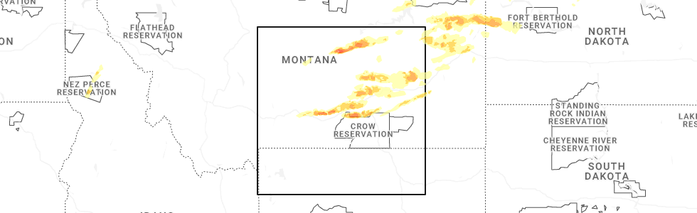
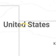
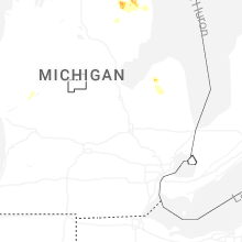
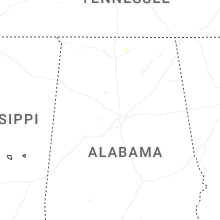
Hail Map for Thursday, August 7, 2025
Number of Impacted Households on 8/7/2025
0
Impacted by 1" or Larger Hail
0
Impacted by 1.75" or Larger Hail
0
Impacted by 2.5" or Larger Hail
Square Miles of Populated Area Impacted on 8/7/2025
0
Impacted by 1" or Larger Hail
0
Impacted by 1.75" or Larger Hail
0
Impacted by 2.5" or Larger Hail
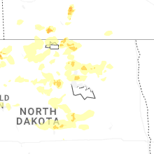


Cities Most Affected by Hail Storms of 8/7/2025
| Hail Size | Demographics of Zip Codes Affected | ||||||
|---|---|---|---|---|---|---|---|
| City | Count | Average | Largest | Pop Density | House Value | Income | Age |
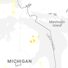
| Lachine, MI | 2 | 2.00 | 2.00 | 13 | $73k | $33.8k | 47.8 |
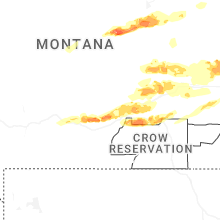
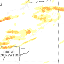
| Molt, MT | 2 | 1.75 | 1.75 | 2 | $95k | $39.7k | 45.7 |
| Bird City, KS | 1 | 2.00 | 2.00 | 1 | $43k | $27.5k | 46.6 |
| Glendive, MT | 1 | 2.00 | 2.00 | 6 | $64k | $31.8k | 42.9 |
| Alpena, MI | 1 | 2.00 | 2.00 | 109 | $80k | $34.2k | 45.6 |
| Powers Lake, ND | 1 | 1.75 | 1.75 | 1 | $41k | $27.3k | 45.7 |
Hail and Wind Damage Spotted on 8/7/2025
Filter by Report Type:Hail ReportsWind Reports
States Impacted
Montana, Missouri, Iowa, North Dakota, Michigan, Louisiana, Kansas, South Dakota, MinnesotaMontana
| Local Time | Report Details |
|---|---|
| 6:45 AM MDT | Glendive... dawson community airport... mt (asos/awos - ggw) 28g5 in dawson county MT, 71 miles NE of Miles City, MT |
| 8:17 AM MDT | Quarter sized hail reported near Glendive, MT, 72.7 miles NE of Miles City, MT, hail with heavy rain. report via facebook. |
| 8:20 AM MDT | Hen Egg sized hail reported near Glendive, MT, 70.1 miles NE of Miles City, MT, hail lasted about 20 minutes. largest stones were about 2 inches. |
| 8:22 AM MDT | Quarter sized hail reported near Glendive, MT, 72.7 miles NE of Miles City, MT |
| 8:23 AM MDT | Quarter sized hail reported near Glendive, MT, 72.7 miles NE of Miles City, MT, hail with little to no wind. |
| 8:31 AM MDT | Quarter sized hail reported near Glendive, MT, 72.7 miles NE of Miles City, MT, one inch hail verified from photo on facebook. |
| 8:38 AM MDT | Quarter sized hail reported near Glendive, MT, 72.7 miles NE of Miles City, MT, the observer indicated that the hail had begun about 15 minutes prior to the call. it was still ongoing. very little wind. heavy rain. |
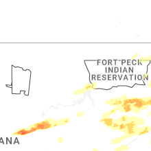
| 3:27 PM MDT | Quarter sized hail reported near Grass Range, MT, 86.6 miles N of Billings, MT, spotter estimated hail up to an inch in size. |
| 3:29 PM MDT | Quarter sized hail reported near Grass Range, MT, 87.2 miles N of Billings, MT, wind shield cracked from falling hail. |
| 5:20 PM MDT | Golf Ball sized hail reported near Molt, MT, 22.4 miles W of Billings, MT, large hail lasted 10 min. |
| 5:22 PM MDT | Ping Pong Ball sized hail reported near Molt, MT, 16.2 miles W of Billings, MT |
| 5:30 PM MDT | Ping Pong Ball sized hail reported near Billings, MT, 1.2 miles WNW of Billings, MT |
| 5:33 PM MDT | Ping Pong Ball sized hail reported near Molt, MT, 14.7 miles W of Billings, MT |
| 5:39 PM MDT | Quarter sized hail reported near Billings, MT, 9 miles W of Billings, MT |
| 5:46 PM MDT | Quarter sized hail reported near Billings, MT, 6.1 miles W of Billings, MT, some hail drifts also reported. |
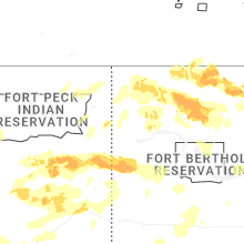
| 5:48 PM MDT | Storms generated 2 inch rainfall in under 2 hrs with wind gusts to 60 mph. power out in the are in valley county MT, 12.3 miles SSE of Glasgow, MT |
| 5:50 PM MDT | Half Dollar sized hail reported near Billings, MT, 2.4 miles WNW of Billings, MT, report from mping: half dollar (1.25 in.). |
| 5:52 PM MDT | Quarter sized hail reported near Billings, MT, 2.2 miles W of Billings, MT |
| 5:56 PM MDT | Wind is based on mesonet and velocity data combined with multiple public estimated reports in the are in mccone county MT, 16.8 miles SE of Glasgow, MT |
| 5:59 PM MDT | Half Dollar sized hail reported near Billings, MT, 1.1 miles NNE of Billings, MT |
| 6:14 PM MDT | Quarter sized hail reported near Billings, MT, 7 miles W of Billings, MT, facebook comment. |
| 6:16 PM MDT | Quarter sized hail reported near Billings, MT, 3.7 miles WNW of Billings, MT, 0.12 in rain. |
| 6:20 PM MDT | Golf Ball sized hail reported near Molt, MT, 13 miles W of Billings, MT, facebook comment. |
| 6:52 PM MDT | Quarter sized hail reported near Shepherd, MT, 13.1 miles NE of Billings, MT, facebook comment. |
| 7:00 PM MDT | Quarter sized hail reported near Hardin, MT, 42.1 miles E of Billings, MT |
| 7:00 PM MDT | Mesonet station mting 1.6 w ingomar (mt dot in rosebud county MT, 74.9 miles W of Miles City, MT |
| 7:05 PM MDT | Quarter sized hail reported near Hardin, MT, 43 miles E of Billings, MT |
| 7:10 PM MDT | Storm damage reported in treasure county MT, 67.1 miles WSW of Miles City, MT |
| 7:35 PM MDT | Storm damage reported in rosebud county MT, 38.1 miles WSW of Miles City, MT |
| 7:38 PM MDT | Accompanied by heavy rai in richland county MT, 56.1 miles SW of Williston, ND |
| 7:39 PM MDT | Mesonet station ew1247 forsyt in rosebud county MT, 41.4 miles W of Miles City, MT |
| 7:40 PM MDT | 3 inch tree limb downe in rosebud county MT, 40.9 miles W of Miles City, MT |
| 7:45 PM MDT | Dw8633 lambert... mt (aprswxnet/cwop in richland county MT, 55.3 miles WSW of Williston, ND |
| 7:45 PM MDT | Storm damage reported in rosebud county MT, 24 miles WSW of Miles City, MT |
| 7:48 PM MDT | Quarter sized hail reported near Lambert, MT, 56.1 miles SW of Williston, ND |
| 7:59 PM MDT | Mesonet station mccm8 cow cree in rosebud county MT, 30.7 miles SSW of Miles City, MT |
| 8:15 PM MDT | Asos station kmls miles cit in custer county MT, 2.2 miles NW of Miles City, MT |
| 9:37 PM MDT | Asos station kbhk bake in fallon county MT, 76.5 miles E of Miles City, MT |
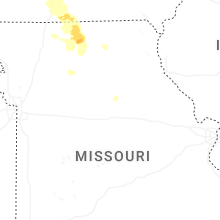
Missouri
| Local Time | Report Details |
|---|---|
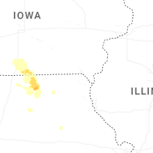
| 8:57 AM CDT | Trees uprooted just south of the iowa state line along us highway 65 north of merce in mercer county MO, 70.5 miles S of Des Moines, IA |
| 9:00 AM CDT | Structure damaged and power pole snapped on west side of merce in mercer county MO, 74.6 miles S of Des Moines, IA |
| 9:26 AM CDT | Large tree limbs downed in newtow in sullivan county MO, 84.7 miles S of Des Moines, IA |
| 9:32 AM CDT | Tree limbs downed in harri in sullivan county MO, 86.4 miles W of Kahoka, MO |
| 9:55 AM CDT | Estimated wind gusts up to 65 mph northwest of mila in sullivan county MO, 77.8 miles W of Kahoka, MO |
| 10:02 AM CDT | Estimated 60 mph winds north of gal in grundy county MO, 90.4 miles WSW of Kahoka, MO |
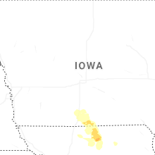
Iowa
| Local Time | Report Details |
|---|---|
| 8:58 AM CDT | Delayed report. damage to tin buildings in town. trailers shifted on foundation. tree limbs down and some trees uprooted. time estimated from rada in wayne county IA, 69.2 miles S of Des Moines, IA |
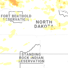
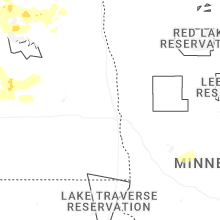
North Dakota
| Local Time | Report Details |
|---|---|
| 9:50 AM CDT | Corrects previous non-tstm wnd gst report from 2 sw moorhead. mesonet station mn098 moorhead mn do in clay county MN, 1.8 miles S of Fargo, ND |
| 5:16 PM CDT | Quarter sized hail reported near Rolla, ND, 62.4 miles NW of Devils Lake, ND, quarter size hail falling in rolla at the time of report. |
| 7:15 PM CDT | Quarter sized hail reported near Alamo, ND, 41.4 miles NNE of Williston, ND, accompanied by lots of small hail but some quarters. crop damage. |
| 7:15 PM CDT | Corrects previous report from 8 nnw corinth. accompanied by lots of small hail and some quarter size hail. crop damag in divide county ND, 41.4 miles NNE of Williston, ND |
| 7:16 PM CDT | Half Dollar sized hail reported near Columbus, ND, 66.5 miles NE of Williston, ND |
| 7:36 PM CDT | Quarter sized hail reported near Lignite, ND, 70.8 miles NE of Williston, ND |
| 7:38 PM CDT | Quarter sized hail reported near Wildrose, ND, 39.1 miles NNE of Williston, ND, fire chief reports 1 inch (quarter sized) hail. relayed through emergency manager. |
| 7:45 PM CDT | Half Dollar sized hail reported near Columbus, ND, 64.8 miles NE of Williston, ND |
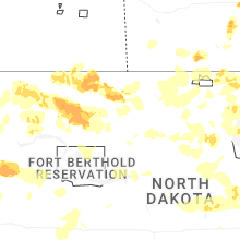
| 8:12 PM CDT | Quarter sized hail reported near Epping, ND, 14.8 miles NE of Williston, ND, report from mping: quarter (1.00 in.). |
| 8:15 PM CDT | Storm damage reported in williams county ND, 37 miles ENE of Williston, ND |
| 8:18 PM CDT | Ndawn station dry fork 1se. report at 10 meters... 55 mph at the surfac in williams county ND, 34.4 miles E of Williston, ND |
| 8:22 PM CDT | Emergency manager also reports small hail the size of pennies and lots of rain. visibility is down to around 300ft (estimated in burke county ND, 58.6 miles NW of Minot, ND |
| 8:28 PM CDT | Ndawn station powers lake 6se. report at 10 meters... 51 mph observed at the surfac in mountrail county ND, 54 miles ENE of Williston, ND |
| 8:33 PM CDT | Golf Ball sized hail reported near Powers Lake, ND, 53.1 miles ENE of Williston, ND, emergency manager sent video showing rain and hail (up to the size of golf balls). |
| 8:41 PM CDT | Stanley 8sw ndaw in mountrail county ND, 51.8 miles E of Williston, ND |
| 8:56 PM CDT | New town dot sit in mckenzie county ND, 50.5 miles ESE of Williston, ND |
| 9:03 PM CDT | Quarter sized hail reported near Stanley, ND, 50.3 miles W of Minot, ND, local ham radio operator report. |
| 9:07 PM CDT | Ndawn station palermo 8n. report at surfac in mountrail county ND, 45.3 miles WNW of Minot, ND |
| 9:15 PM CDT | Ndawn station shell lake 2se. report at 10 meters... 48 mph observed at the surfac in mountrail county ND, 36.2 miles W of Minot, ND |
| 9:30 PM CDT | Nddot station blaisedell us- in mountrail county ND, 34.9 miles W of Minot, ND |
| 9:31 PM CDT | Awos station k1nn 3 w mohal in renville county ND, 38.6 miles NNW of Minot, ND |
| 9:55 PM CDT | Awos station k1on 10 s antle in bottineau county ND, 40.4 miles N of Minot, ND |
| 10:17 PM CDT | Asos station kmot minot airpor in ward county ND, 1.5 miles NE of Minot, ND |
| 9:20 PM MDT | Ndawn station grassy butte 2e. report at 10 meters... 52 mph at the surfac in mckenzie county ND, 55.7 miles SSE of Williston, ND |
| 9:24 PM MDT | Nddot station grassy butte us-85. time estimated via rada in mckenzie county ND, 53.8 miles SSE of Williston, ND |
| 10:25 PM CDT | Ndawn station 3 n ray. report at 10 meters... 61 mph observed at the surfac in williams county ND, 27.2 miles NE of Williston, ND |
| 10:25 PM CDT | Ndawn station ray 4n. reported at 10 meters... 61 mph observed at the surfac in williams county ND, 27.2 miles NE of Williston, ND |
| 10:40 PM CDT | Emergency manager relays image of a camper-trailer flipped on highway 2... at the williams county... mountrail county line. at 10:20 pm ct... the line of storms was pro in williams county ND, 38.9 miles ENE of Williston, ND |
| 9:55 PM MDT | Ndawn station marmarth 2n. report at 10 meters... 58 mph observed at the surfac in slope county ND, 91.5 miles E of Miles City, MT |
| 11:04 PM CDT | Power poles down. radar estimated tim in bottineau county ND, 54 miles NE of Minot, ND |
| 10:15 PM MDT | Mesonet station amdn8 sand creek. time estimated by rada in slope county ND, 110.4 miles S of Williston, ND |
| 10:25 PM MDT | Ndawn station amidon 1ne. report at 10 meters... 54 mph observed at the surfac in slope county ND, 115.3 miles S of Williston, ND |
| 11:30 PM CDT | Storm damage reported in bottineau county ND, 42.3 miles NNE of Minot, ND |
| 10:39 PM MDT | Storm damage reported in bowman county ND, 123.1 miles E of Miles City, MT |
| 10:43 PM MDT | Ndawn station new england 5w. report at 10 meters... 47 mph observed at the surfac in slope county ND, 105.9 miles W of Bismarck, ND |
| 10:51 PM MDT | Private weather station observation relayed via emergency manage in stark county ND, 96.5 miles SSE of Williston, ND |
| 11:10 PM MDT | Ndawn station lefor 10se. report at 10 meters... 59 mph observed at the surfac in hettinger county ND, 78 miles W of Bismarck, ND |
| 11:11 PM MDT | Ndawn station halliday 4n. reported at 10 meters... 56 mph observed at the surfac in dunn county ND, 74.9 miles SW of Minot, ND |
| 11:15 PM MDT | Ndawn station manning 4sw. report at 10 meters... 57 mph observed at the surfac in dunn county ND, 75.7 miles SSE of Williston, ND |
| 11:24 PM MDT | Ndawn station manning 4sw. report at 10 meters... 61 mph observed at the surface. report was made well behind the line of thunderstorms... with no lightning in the area in dunn county ND, 75.7 miles SSE of Williston, ND |
| 11:34 PM MDT | Ndawn station elgin 10nw. reported at 10 meters... 51 mph observed at the surfac in grant county ND, 61.3 miles WSW of Bismarck, ND |
| 1:09 AM CDT | Mesonet station cw2059 6 n bismarc in burleigh county ND, 6.6 miles N of Bismarck, ND |
| 1:15 AM CDT | Asos station kbis bismarck airpor in burleigh county ND, 2.8 miles SSE of Bismarck, ND |
| 1:18 AM CDT | Storm damage reported in burleigh county ND, 1.7 miles NE of Bismarck, ND |
| 1:34 AM CDT | Raws site tatanka prairie nd. time estimated by rada in sioux county ND, 45 miles S of Bismarck, ND |
| 1:40 AM CDT | Mesonet station ts633 long lake nwr. time estimated by rada in burleigh county ND, 27 miles ESE of Bismarck, ND |
| 1:40 AM CDT | Nddot station us-83 hazelton ess. time estimated by rada in emmons county ND, 31 miles SE of Bismarck, ND |
| 1:50 AM CDT | Ndawn station robinson 3nnw. report at 10 meters... 57 mph reported at the surfac in kidder county ND, 52.7 miles ENE of Bismarck, ND |
| 2:11 AM CDT | Nddot station medina i-94 mp. time estimated by rada in stutsman county ND, 71.2 miles E of Bismarck, ND |
| 2:29 AM CDT | Raws station arrowwood 2. time estimated by rada in stutsman county ND, 58.2 miles S of Devils Lake, ND |
| 2:38 AM CDT | Multiple power lines down in yard and part of shop roof off. radar estimated tim in stutsman county ND, 76.3 miles S of Devils Lake, ND |
| 2:40 AM CDT | Ndawn station courtenay 5w. report at 10 meters... 43 mph observed at the surfac in stutsman county ND, 62.2 miles S of Devils Lake, ND |
| 2:41 AM CDT | Asos station kjms jamestown airpor in stutsman county ND, 82.1 miles S of Devils Lake, ND |
| 2:45 AM CDT | Ndawn station courtenay 5w. report at 10 meters... 63 mph observed at the surfac in stutsman county ND, 62.2 miles S of Devils Lake, ND |
| 2:50 AM CDT | Ndawn station ypsilanti 2e. report at 10 meters... 51 mph at the surfac in stutsman county ND, 82.7 miles W of Fargo, ND |
| 3:09 AM CDT | Storm damage reported in barnes county ND, 58.2 miles W of Fargo, ND |
| 3:33 AM CDT | Damage to a shop from strong winds was reported. time estimated via rada in steele county ND, 63 miles SE of Devils Lake, ND |
| 3:36 AM CDT | Hope ndawn mesonet recorded 63 mph wind gust near the surfac in steele county ND, 52.9 miles NW of Fargo, ND |
| 3:50 AM CDT | Corrects previous non-tstm wnd gst report from 2 e logan center. mesonet station 325332 logan center nd ndaw in grand forks county ND, 54.9 miles ESE of Devils Lake, ND |
| 3:51 AM CDT | Report at 10 meters. 53 mph at the surfac in grand forks county ND, 54.9 miles ESE of Devils Lake, ND |
| 3:55 AM CDT | Corrects previous non-tstm wnd gst report from 3 e mayville. mesonet station 325679 mayville nd ndaw in traill county ND, 48.6 miles NNW of Fargo, ND |
| 3:55 AM CDT | 10 meter wind sensor at the casselton ndaw in cass county ND, 16.6 miles WNW of Fargo, ND |
| 3:56 AM CDT | Report at 10 meters. 58 mph at the surfac in grand forks county ND, 54.9 miles ESE of Devils Lake, ND |
| 4:00 AM CDT | Report of a power line down in mayville. winds estimated at 75 mph. time estimated via rada in traill county ND, 50.3 miles NNW of Fargo, ND |
| 4:03 AM CDT | At i-29 near buxton... a semi was reported blown over by the public (relayed via media). time estimated via rada in traill county ND, 52 miles NNW of Fargo, ND |
| 4:12 AM CDT | Corrects previous non-tstm wnd gst report from 6 wnw grand forks. asos station kgfk grand forks ap n in grand forks county ND, 76.5 miles NNW of Fargo, ND |
| 4:12 AM CDT | Grand forks air force base recorded wind gust of 91 mp in grand forks county ND, 68.2 miles E of Devils Lake, ND |
| 4:15 AM CDT | A tree 4-5 inches in diameter and ~ 10 ft tall was reported dow in cass county ND, 5.7 miles WSW of Fargo, ND |
| 4:20 AM CDT | Ndawn mesonet at emerado (33ft in grand forks county ND, 70.7 miles E of Devils Lake, ND |
Michigan
| Local Time | Report Details |
|---|---|
| 4:00 PM EDT | Quarter sized hail reported near Owendale, MI, 54.7 miles NNE of Flint, MI |
| 7:00 PM EDT | Hen Egg sized hail reported near Lachine, MI, 14 miles W of Alpena, MI, corrects previous hail report from lachine. report on fakebook displayed individual holding large hail stone. they stated that it was 2 inches in diameter. |
| 7:10 PM EDT | Quarter sized hail reported near Spruce, MI, 17.7 miles S of Alpena, MI, via x/twitter. |
| 7:41 PM EDT | Hen Egg sized hail reported near Lachine, MI, 14 miles W of Alpena, MI, report on fakebook displayed individual holding large hail stone. they stated that it was 2 inches in diameter. |
| 8:31 PM EDT | Hen Egg sized hail reported near Alpena, MI, 6.3 miles ENE of Alpena, MI, corrects previous hail report from 6 e alpena. facebook report with a 2 inch hail stone near misery bay... east of alpena. |
Louisiana
| Local Time | Report Details |
|---|---|
| 5:02 PM CDT | Law enforcement reported a tree down on fish hatchery road near lacomb in st. tammany county LA, 27 miles NNE of New Orleans, LA |
| 5:45 PM CDT | Law enforcement reported of power lines down on george rouyea road near cannon roa in ascension county LA, 52.8 miles WNW of New Orleans, LA |
Kansas
| Local Time | Report Details |
|---|---|
| 6:41 PM CDT | Half Dollar sized hail reported near Bird City, KS, 35.5 miles NW of Colby, KS, public report of hail up to 1-1.25 inches in bird city. |
| 7:00 PM CDT | Corrects previous wildfire report from bird city. public report of large steel tank rolled. time estimate in cheyenne county KS, 35.5 miles NW of Colby, KS |
| 7:05 PM CDT | Public report of 2 trees and 2 large branches knocked over in bird cit in cheyenne county KS, 35.5 miles NW of Colby, KS |
| 7:45 PM CDT | Hen Egg sized hail reported near Bird City, KS, 36 miles NW of Colby, KS, delayed report of estimated 2 inch hail in bird city with photo. multiple stones around 1-1.5 inches. time estimated. |
| 10:50 PM CDT | K5adt reported 63 mph gus in rawlins county KS, 27.5 miles NNW of Colby, KS |
| 11:00 PM CDT | Kadt awos reported 52 knots gus in rawlins county KS, 30.6 miles N of Colby, KS |
| 11:05 PM CDT | K5adt reported 63 mph gus in rawlins county KS, 27.5 miles NNW of Colby, KS |
| 11:10 PM CDT | Awos station kadt 1 nnw atwoo in rawlins county KS, 29.9 miles N of Colby, KS |
| 11:10 PM CDT | Ks-ludell3n reported 60 mph gus in rawlins county KS, 35 miles N of Colby, KS |
| 11:29 PM CDT | Ks-ludell3n reported 69 mph gus in rawlins county KS, 35 miles N of Colby, KS |
| 2:45 AM CDT | Site ashley_farm (awn) measured 63 mph wind gus in decatur county KS, 26.5 miles ENE of Colby, KS |
South Dakota
| Local Time | Report Details |
|---|---|
| 1:06 AM MDT | Mesonet station 205 mclaughlin (sddot in corson county SD, 66.3 miles S of Bismarck, ND |
| 1:06 AM MDT | Mesonet station grrs2 bullhead 10 in corson county SD, 83.7 miles S of Bismarck, ND |
| 2:25 AM CDT | Storm damage reported in campbell county SD, 70.2 miles SSE of Bismarck, ND |
| 2:25 AM CDT | Corrects previous tstm wnd gst report from 6 n herrei in campbell county SD, 70.2 miles SSE of Bismarck, ND |
| 2:39 AM CDT | Storm damage reported in campbell county SD, 69.9 miles WNW of Aberdeen, SD |
| 3:15 AM CDT | Mesonet station lrms2 lowry 2s (sd mesonet in walworth county SD, 65.5 miles NNE of Pierre, SD |
| 3:15 AM CDT | Storm damage reported in mcpherson county SD, 47.9 miles WNW of Aberdeen, SD |
| 3:16 AM CDT | Mesonet station 216 bowdle (sddot in edmunds county SD, 56 miles W of Aberdeen, SD |
| 3:20 AM CDT | Mesonet station bwls2 bowdle (sd mesonet in edmunds county SD, 57.5 miles W of Aberdeen, SD |
| 3:21 AM CDT | Mesonet station 157 forest city (sddot in potter county SD, 44.4 miles N of Pierre, SD |
| 3:25 AM CDT | Sdsu mesonet gettysburg wes in potter county SD, 44.6 miles N of Pierre, SD |
| 3:36 AM CDT | Mesonet station 56 tolstoy (sddot in potter county SD, 57.5 miles WSW of Aberdeen, SD |
| 3:41 AM CDT | Mesonet station 212 agar (sddot in potter county SD, 39 miles NNE of Pierre, SD |
| 4:26 AM CDT | Asos station kabr aberdeen rgnl a in brown county SD, 3.3 miles E of Aberdeen, SD |
Minnesota
| Local Time | Report Details |
|---|---|
| 4:35 AM CDT | Crookston airport measured peak gust via 1 min observatio in polk county MN, 67.7 miles N of Fargo, ND |
| 4:41 AM CDT | 75 mph wind gust recorded at the surfac in marshall county MN, 70.6 miles SW of Roseau, MN |
Connect with Interactive Hail Maps