

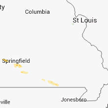
Hail Map for Thursday, September 20, 2012

Number of Impacted Households on 9/20/2012
0
Impacted by 1" or Larger Hail
0
Impacted by 1.75" or Larger Hail
0
Impacted by 2.5" or Larger Hail
Square Miles of Populated Area Impacted on 9/20/2012
0
Impacted by 1" or Larger Hail
0
Impacted by 1.75" or Larger Hail
0
Impacted by 2.5" or Larger Hail


Cities Most Affected by Hail Storms of 9/20/2012
| Hail Size | Demographics of Zip Codes Affected | ||||||
|---|---|---|---|---|---|---|---|
| City | Count | Average | Largest | Pop Density | House Value | Income | Age |
Hail and Wind Damage Spotted on 9/20/2012
Filter by Report Type:Hail ReportsWind Reports
Florida
| Local Time | Report Details |
|---|---|
| 1:15 PM EDT | The 911 call center received a report of telephone lines blown down at canal road and rosco blvd. the time given was based on rada in st. johns county FL, 18.5 miles SE of Jacksonville, FL |
| 3:15 PM EDT | Public reports a large tree downed near 180th street in luraville. time of damage based on radar dat in suwannee county FL, 71.1 miles ESE of Tallahassee, FL |
Georgia
| Local Time | Report Details |
|---|---|
| 1:50 PM EDT | Trees down on house in lowndes county GA, 50.7 miles SSW of Douglas, GA |
| 2:08 PM EDT | The sheriffs office reported trees and powerlines down in folkston. the time given was based on rada in charlton county GA, 40.9 miles NNW of Jacksonville, FL |
| 3:25 PM EDT | Trees and powerlines down south of vsu campu in lowndes county GA, 52.2 miles SSW of Douglas, GA |
| 3:41 PM EDT | Trees and powerlines down south of vsu campu in lowndes county GA, 52.2 miles SSW of Douglas, GA |
| 3:41 PM EDT | Trees and powerlines down south of vsu campus.two 90 ft pines in lowndes county GA, 52.2 miles SSW of Douglas, GA |
| 3:50 PM EDT | Trees down on house in lowndes county GA, 50.7 miles SSW of Douglas, GA |
| 3:56 PM EDT | Trees down and car accident in lowndes county GA, 52.8 miles SSW of Douglas, GA |
| 4:29 PM EDT | Trees down and car accident in lowndes county GA, 52.8 miles SSW of Douglas, GA |
| 4:29 PM EDT | Trees and power lines dow in lowndes county GA, 48 miles SSW of Douglas, GA |
Missouri
| Local Time | Report Details |
|---|---|
| 1:47 AM CDT | Quarter sized hail reported near Springfield, MO, 2.7 miles ENE of Springfield, MO |
| 1:51 AM CDT | Quarter sized hail reported near Springfield, MO, 2.7 miles W of Springfield, MO |
| 1:57 AM CDT | Quarter sized hail reported near Springfield, MO, 4.9 miles NE of Springfield, MO, quarter sized hail reported at i-44/u.s. 65 intersection in northeastern springfield. |
Connect with Interactive Hail Maps