

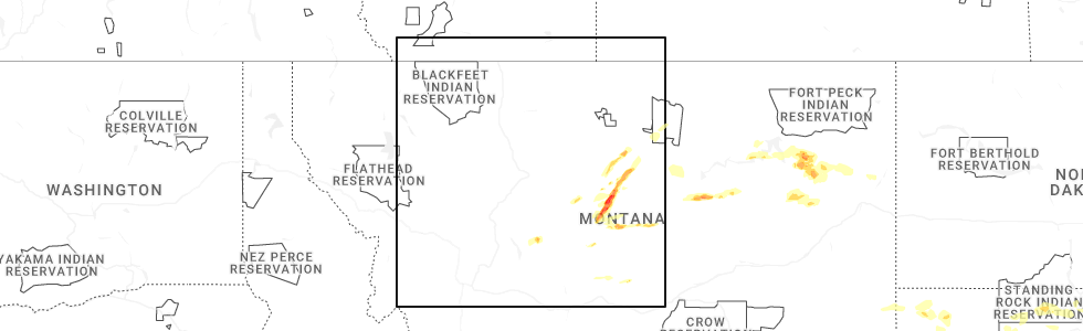
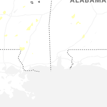
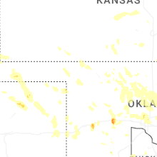
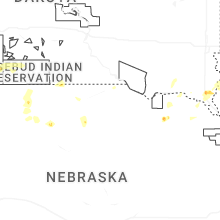
Hail Map for Saturday, June 14, 2025
Number of Impacted Households on 6/14/2025
0
Impacted by 1" or Larger Hail
0
Impacted by 1.75" or Larger Hail
0
Impacted by 2.5" or Larger Hail
Square Miles of Populated Area Impacted on 6/14/2025
0
Impacted by 1" or Larger Hail
0
Impacted by 1.75" or Larger Hail
0
Impacted by 2.5" or Larger Hail
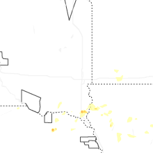


Cities Most Affected by Hail Storms of 6/14/2025
| Hail Size | Demographics of Zip Codes Affected | ||||||
|---|---|---|---|---|---|---|---|
| City | Count | Average | Largest | Pop Density | House Value | Income | Age |
| Hydro, OK | 4 | 2.09 | 2.50 | 10 | $51k | $29.9k | 39.3 |
| Hobson, MT | 2 | 1.88 | 2.00 | 1 | $65k | $31.4k | 49.0 |
| Lewistown, MT | 2 | 1.75 | 1.75 | 8 | $74k | $30.8k | 47.6 |
| Colorado Springs, CO | 1 | 1.75 | 1.75 | 781 | $183k | $44.7k | 38.3 |
| Moccasin, MT | 1 | 1.75 | 1.75 | 1 | $45k | $28.1k | 52.3 |
| Moore, MT | 1 | 1.75 | 1.75 | 1 | $60k | $31.1k | 46.0 |
| Thomas, OK | 1 | 1.75 | 1.75 | 7 | $42k | $31.9k | 38.9 |
| Edmond, OK | 1 | 1.75 | 1.75 | 1586 | $115k | $55.7k | 35.2 |
Hail and Wind Damage Spotted on 6/14/2025
Filter by Report Type:Hail ReportsWind Reports
States Impacted
Kansas, Florida, Louisiana, Oklahoma, North Carolina, Virginia, Mississippi, Alabama, Texas, Arkansas, Georgia, West Virginia, Iowa, Montana, Colorado, South Dakota, Nebraska, WyomingKansas
| Local Time | Report Details |
|---|---|
| 7:27 AM CDT | Storm damage reported in reno county KS, 57.5 miles W of Wichita, KS |
| 7:46 AM CDT | Storm damage reported in reno county KS, 38.5 miles NW of Wichita, KS |
| 7:51 AM CDT | Storm damage reported in reno county KS, 43.5 miles NW of Wichita, KS |
| 8:05 AM CDT | Storm damage reported in mcpherson county KS, 40.6 miles NNW of Wichita, KS |
| 9:04 AM CDT | Storm damage reported in sumner county KS, 21.1 miles SSE of Wichita, KS |
| 9:15 AM CDT | Storm damage reported in cowley county KS, 23.7 miles SSE of Wichita, KS |
Florida
| Local Time | Report Details |
|---|---|
| 12:45 PM EDT | Road closed at the intersection of w newberry rd and nw 120th terrace in gainesville due to a fallen tree and downed power lines. time est. based off rada in alachua county FL, 67.2 miles SW of Jacksonville, FL |
| 3:30 PM EDT | Fallen tree on sw 170th street lead to temporarily closure. time based off radar and repor in alachua county FL, 71.8 miles SW of Jacksonville, FL |
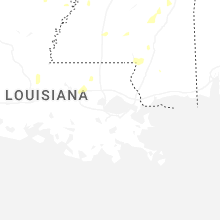
Louisiana
| Local Time | Report Details |
|---|---|
| 12:00 PM CDT | Tree down on moore ave in walke in livingston county LA, 59.6 miles NW of New Orleans, LA |
| 7:45 PM CDT | Trees downed around black lake hosston including near coatney road and nichols camp roa in caddo county LA, 28.7 miles NNW of Shreveport, LA |
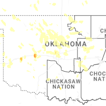
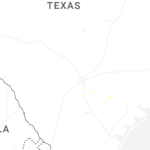
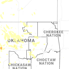
Oklahoma
| Local Time | Report Details |
|---|---|
| 12:40 PM CDT | Tree blown down at holdenville lake. time estimated from rada in hughes county OK, 46.5 miles NNW of Atoka, OK |
| 1:05 PM CDT | Quarter sized hail reported near Ada, OK, 37.8 miles NW of Atoka, OK, report from mping: quarter (1.00 in.). |
| 6:20 PM CDT | Golf Ball sized hail reported near Thomas, OK, 60.7 miles SE of Woodward, OK |
| 7:50 PM CDT | Hen Egg sized hail reported near Hydro, OK, 61.1 miles W of Oklahoma City, OK |
| 7:52 PM CDT | Tennis Ball sized hail reported near Hydro, OK, 60 miles W of Oklahoma City, OK |
| 7:56 PM CDT | Golf Ball sized hail reported near Hydro, OK, 59.9 miles W of Oklahoma City, OK, intersection of highway 58 and interstate 40. |
| 8:00 PM CDT | Ping Pong Ball sized hail reported near Hydro, OK, 55.4 miles W of Oklahoma City, OK, report from mping: ping pong ball (1.50 in.). |
| 8:04 PM CDT | Half Dollar sized hail reported near Hydro, OK, 58.2 miles W of Oklahoma City, OK |
| 8:06 PM CDT | Hen Egg sized hail reported near Hydro, OK, 59.2 miles W of Oklahoma City, OK, report from mping: hen egg (2.00 in.). |
| 8:57 PM CDT | Quarter sized hail reported near Burns Flat, OK, 75 miles S of Woodward, OK, relayed via social media. |
| 11:27 PM CDT | Half Dollar sized hail reported near Tryon, OK, 43.3 miles NE of Oklahoma City, OK, report from mping: half dollar (1.25 in.). |
| 11:53 PM CDT | Half Dollar sized hail reported near Edmond, OK, 12.3 miles NNW of Oklahoma City, OK, report from mping: half dollar (1.25 in.). |
| 11:54 PM CDT | Quarter sized hail reported near Edmond, OK, 14 miles NNW of Oklahoma City, OK, report from mping: quarter (1.00 in.). |
| 12:00 AM CDT | Golf Ball sized hail reported near Edmond, OK, 10.9 miles N of Oklahoma City, OK, a few hail stones up to golf ball size. |
| 12:02 AM CDT | Half Dollar sized hail reported near Edmond, OK, 11.6 miles N of Oklahoma City, OK, report from mping: half dollar (1.25 in.). |
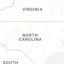
North Carolina
| Local Time | Report Details |
|---|---|
| 2:00 PM EDT | Surry county 911 call center reported a tree down near the intersection of massey road and saint marie trail in mount airy... nc. time is estimated from rada in surry county NC, 64.8 miles SSW of Roanoke, VA |
| 2:00 PM EDT | Delayed report: surry county 911 call center reported a tree fell across rockford road near dobson... blocking both lanes. time is estimated from rada in surry county NC, 76.5 miles SSW of Roanoke, VA |
| 2:18 PM EDT | Delayed report: surry county 911 call center reported that two trees are down on hardy road in siloam... nc. time is estimated from rada in surry county NC, 75.4 miles NNE of Charlotte, NC |
| 2:28 PM EDT | Tree down... blocking one lane of country club roa in yadkin county NC, 64.7 miles N of Charlotte, NC |
| 6:08 PM EDT | Ham radio operator reported a tree blown down at hibriten dr and woodridge d in caldwell county NC, 61 miles NW of Charlotte, NC |
| 7:25 PM EDT | Ham radio operator reported a tree blown down on power lines on stout farm r in alexander county NC, 53.6 miles NNW of Charlotte, NC |
Virginia
| Local Time | Report Details |
|---|---|
| 3:05 PM EDT | Henry county 911 call center reported a tree down blocking one lane on cameron road in martinsville... v in henry county VA, 42.9 miles S of Roanoke, VA |
| 6:08 PM EDT | Multiple trees knocked down along us-58 east. time estimated from rada in city of suffolk county VA, 23.4 miles W of Virginia Beach, VA |
| 9:40 PM EDT | Numerous roads were closed due to high water with some vehicles strande in shenandoah county VA, 74.6 miles E of Elkins, WV |
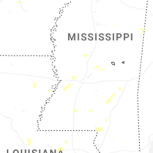
Mississippi
| Local Time | Report Details |
|---|---|
| 2:27 PM CDT | A tree was downed across blackjack rd blocking traffi in covington county MS, 54 miles SSE of Jackson, MS |
| 2:50 PM CDT | A utility pole was downed blocking traffic near the intersection of oak grove rd and griffith r in lamar county MS, 83.6 miles SE of Jackson, MS |
| 3:30 PM CDT | A tree was downed on y camp r in claiborne county MS, 51.5 miles WSW of Jackson, MS |
| 3:30 PM CDT | Trees downed on johnson ln and chicago plantation r in claiborne county MS, 49.3 miles WSW of Jackson, MS |
| 3:47 PM CDT | Trees were downed at multiple locations on ms hwy 1 in claiborne county MS, 39.2 miles WSW of Jackson, MS |
| 4:05 PM CDT | There have been numerous reports of downed trees and a powerline across the count in hinds county MS, 22.7 miles WSW of Jackson, MS |
| 4:43 PM CDT | Multiple trees downe in madison county MS, 18.5 miles NNW of Jackson, MS |
| 4:52 PM CDT | A tree was blown down onto powerlines on maple street in jackso in hinds county MS, 1.9 miles NW of Jackson, MS |
| 5:20 PM CDT | A tree was downed on hwy-16e as well as numerous other trees across the count in madison county MS, 25.3 miles NNE of Jackson, MS |
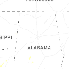
Alabama
| Local Time | Report Details |
|---|---|
| 2:57 PM CDT | Tree and power line down in centr in cherokee county AL, 66 miles SSW of Chattanooga, TN |
| 3:15 PM CDT | Tree and power lines dow in jefferson county AL, 6 miles ESE of Birmingham, AL |
| 3:18 PM CDT | Tree down at highway 9 and county road 12 in cherokee county AL, 55.7 miles S of Chattanooga, TN |
| 4:29 PM CDT | Tree reported down along old highway 25 near the intersection with cr 3 in shelby county AL, 26.5 miles SSE of Birmingham, AL |
| 5:27 PM CDT | Report of a tree down near ridge marina wa in elmore county AL, 25.8 miles WNW of Auburn, AL |
| 5:38 PM CDT | Multiple trees down across horseshoe bend road near wisel road. aldot remains on scene clearing tree in tallapoosa county AL, 25.2 miles NW of Auburn, AL |
| 6:09 PM CDT | Trees dow in franklin county AL, 31.1 miles S of Florence, AL |
| 6:15 PM CDT | Video and photos on facebook of a woman who survived a large tree falling on her car and was able to escape without injury. time and location approximat in chambers county AL, 20.7 miles NNE of Auburn, AL |
| 6:25 PM CDT | Tree and a powerline fell on a hous in lawrence county AL, 32.6 miles SE of Florence, AL |
| 7:53 PM CDT | Pine tree down across the roa in cullman county AL, 53.1 miles N of Birmingham, AL |
Texas
| Local Time | Report Details |
|---|---|
| 3:25 PM CDT | Mesonet station 156 marfa 13s in presidio county TX, 19.7 miles SW of Alpine, TX |
| 3:52 AM CDT | Wind gusts over 60 mph continued until 3:54 a in hansford county TX, 87.6 miles NNE of Amarillo, TX |
| 4:05 AM CDT | Storm damage reported in hansford county TX, 78.6 miles NNE of Amarillo, TX |
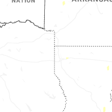
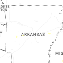
Arkansas
| Local Time | Report Details |
|---|---|
| 3:35 PM CDT | A few trees and powerlines blown down just north of town on 270 in montgomery county AR, 43.8 miles NNE of Nashville, AR |
Georgia
| Local Time | Report Details |
|---|---|
| 4:50 PM EDT | Trees down along antioch r in polk county GA, 48 miles WNW of Atlanta, GA |
| 5:40 PM EDT | Trees down along grady and hightower mountain r in polk county GA, 45.8 miles WNW of Atlanta, GA |
| 8:20 PM EDT | Ga511 reported tree limbs on sr 362 in both directions at near james store rd. all lanes close in meriwether county GA, 47.5 miles SSW of Atlanta, GA |
| 9:15 PM EDT | Ga511 reports tree limbs on sr 36 eastbound at lee maddox rd. all lanes close in butts county GA, 41.4 miles SSE of Atlanta, GA |
| 9:35 PM EDT | Ga511 reports tree limbs on sr 42 in both directions. all lanes close in butts county GA, 44.6 miles SE of Atlanta, GA |
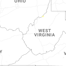
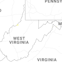
West Virginia
| Local Time | Report Details |
|---|---|
| 5:50 PM EDT | Trees blew down in the 1900 block of cr-24/1 sam mason road between i-81 and us-11 winchester avenu in berkeley county WV, 78.3 miles W of Baltimore, MD |
| 6:08 PM EDT | Trees blew down near the intersection of cr-45/20 cold stream road and cr-4/2 north river mills roa in hampshire county WV, 77.7 miles ENE of Elkins, WV |
| 6:29 PM EDT | Trees blew down in the 2900 block of cr-14 capon river roa in hampshire county WV, 78 miles ENE of Elkins, WV |
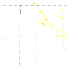
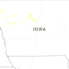
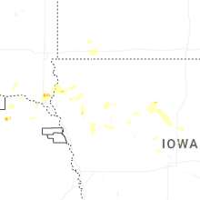
Iowa
| Local Time | Report Details |
|---|---|
| 5:55 PM CDT | Half Dollar sized hail reported near Le Mars, IA, 49.6 miles W of Storm Lake, IA, infrequent larger stones from quarter to half-dollar size. |
| 5:56 PM CDT | Quarter sized hail reported near Le Mars, IA, 49.9 miles WNW of Storm Lake, IA, significant damage to campers at the willow creek campground from hail and wind driven hail. hail lasted around 10 minutes. |
| 6:00 PM CDT | Quarter sized hail reported near Le Mars, IA, 49.6 miles WNW of Storm Lake, IA, hail was observed at the golf course. |
| 7:20 PM CDT | Quarter sized hail reported near Hawarden, IA, 39.7 miles SSE of Sioux Falls, SD, heavy rain and some strong winds as well with small twigs down and some standing water in the backyard. |
| 8:58 PM CDT | Social media pictures of large trees down... some on top on vehicle in woodbury county IA, 34.8 miles W of Storm Lake, IA |
| 9:22 PM CDT | Personal weather statio in woodbury county IA, 35.5 miles WSW of Storm Lake, IA |
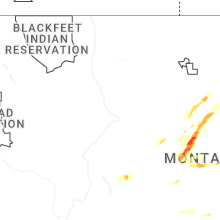
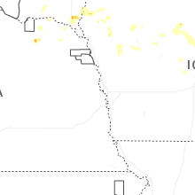
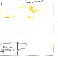
Montana
| Local Time | Report Details |
|---|---|
| 5:20 PM MDT | Half Dollar sized hail reported near Big Timber, MT, 51.1 miles WNW of Billings, MT |
| 6:45 PM MDT | Hen Egg sized hail reported near Hobson, MT, 76.1 miles ESE of Great Falls, MT, spotter reports golf ball to egg size hail. tree damage was also observed. |
| 6:55 PM MDT | Golf Ball sized hail reported near Hobson, MT, 74.9 miles ESE of Great Falls, MT, golf ball to egg size hail reported. additionally... hail damage to vehicle and campers was reported. |
| 6:55 PM MDT | Golf Ball sized hail reported near Moccasin, MT, 75.5 miles ESE of Great Falls, MT, report from social media showed golf ball sized hail as well as significant damage to outdoor play equipment and shattered skylights and windows. time estimated from ra |
| 6:58 PM MDT | Golf Ball sized hail reported near Moore, MT, 78.6 miles ESE of Great Falls, MT, spotter reports golf ball size hail. |
| 7:22 PM MDT | Golf Ball sized hail reported near Lewistown, MT, 76.9 miles ESE of Great Falls, MT, report from social media. ground was almost completely covered with hailstones ranging from quarter to golf ball size. time estimated based on radar. |
| 7:32 PM MDT | Golf Ball sized hail reported near Lewistown, MT, 78.6 miles ESE of Great Falls, MT, patrol car traveling along highway 81 received substantial hail damage. location and time estimated based on radar. |
| 7:55 PM MDT | Corrects previous tstm wnd gst report from 8 wsw suffol in fergus county MT, 78.6 miles S of Havre, MT |
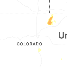
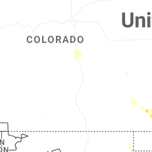
Colorado
| Local Time | Report Details |
|---|---|
| 5:22 PM MDT | Half Dollar sized hail reported near Colorado Springs, CO, 48.2 miles NNW of Pueblo, CO, report from mping: half dollar (1.25 in.). |
| 5:24 PM MDT | Quarter sized hail reported near Colorado Springs, CO, 48.2 miles NNW of Pueblo, CO, report from mping: quarter (1.00 in.). |
| 5:26 PM MDT | Quarter sized hail reported near Colorado Springs, CO, 46.5 miles NNW of Pueblo, CO |
| 5:26 PM MDT | Quarter sized hail reported near Colorado Springs, CO, 47.6 miles NNW of Pueblo, CO, report from mping: quarter (1.00 in.). |
| 5:28 PM MDT | Quarter sized hail reported near Colorado Springs, CO, 47.6 miles NNW of Pueblo, CO, report from mping: quarter (1.00 in.). |
| 5:33 PM MDT | Quarter sized hail reported near Colorado Springs, CO, 49.9 miles N of Pueblo, CO, report from mping: quarter (1.00 in.). |
| 5:35 PM MDT | Quarter sized hail reported near Colorado Springs, CO, 49.3 miles N of Pueblo, CO, report from mping: quarter (1.00 in.). |
| 5:37 PM MDT | Quarter sized hail reported near Colorado Springs, CO, 49.9 miles N of Pueblo, CO, report from mping: quarter (1.00 in.). |
| 5:37 PM MDT | Quarter sized hail reported near Colorado Springs, CO, 46.9 miles NNW of Pueblo, CO |
| 5:38 PM MDT | Quarter sized hail reported near Colorado Springs, CO, 49.9 miles N of Pueblo, CO, report from mping: quarter (1.00 in.). |
| 5:39 PM MDT | Half Dollar sized hail reported near Colorado Springs, CO, 49.9 miles N of Pueblo, CO, report from mping: half dollar (1.25 in.). |
| 5:41 PM MDT | Quarter sized hail reported near Colorado Springs, CO, 49.9 miles N of Pueblo, CO, report from mping: quarter (1.00 in.). |
| 6:00 PM MDT | Quarter sized hail reported near Manitou Springs, CO, 43.3 miles NNW of Pueblo, CO |
| 6:00 PM MDT | Half Dollar sized hail reported near Colorado Springs, CO, 43.9 miles N of Pueblo, CO |
| 6:16 PM MDT | Quarter sized hail reported near Colorado Springs, CO, 40.8 miles NNW of Pueblo, CO, report from mping: quarter (1.00 in.). |
| 6:42 PM MDT | Golf Ball sized hail reported near Colorado Springs, CO, 36.2 miles NNW of Pueblo, CO, hailed ranged in size from peas to golfballs. |
| 7:27 PM MDT | Mesonet station co222 dearfiel in weld county CO, 54.3 miles NE of Denver, CO |
| 7:40 PM MDT | Storm damage reported in weld county CO, 50.4 miles ENE of Denver, CO |
| 7:51 PM MDT | Storm damage reported in morgan county CO, 60.2 miles WNW of Yuma, CO |
| 7:55 PM MDT | Storm damage reported in morgan county CO, 58.8 miles WNW of Yuma, CO |
| 11:12 PM MDT | Ambient weather site struckmeyer reported the gus in yuma county CO, 25.9 miles NE of Yuma, CO |
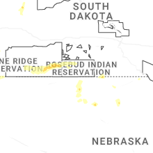
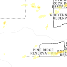
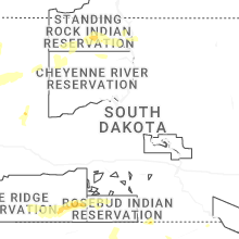
South Dakota
| Local Time | Report Details |
|---|---|
| 6:35 PM CDT | Half Dollar sized hail reported near Burbank, SD, 48.8 miles S of Sioux Falls, SD |
| 10:19 PM MDT | Storm damage reported in fall river county SD, 62.6 miles S of Rapid City, SD |
Nebraska
| Local Time | Report Details |
|---|---|
| 5:55 PM MDT | Mesonet station reported wind gust of 61mph from nearby thunderstor in banner county NE, 29.3 miles SW of Scottsbluff, NE |
Wyoming
| Local Time | Report Details |
|---|---|
| 6:32 PM MDT | Storm damage reported in campbell county WY, 3.7 miles NNW of Gillette, WY |
| 7:10 PM MDT | Quarter sized hail reported near Gillette, WY, 32.5 miles NW of Gillette, WY |
| 7:54 PM MDT | Half Dollar sized hail reported near Buffalo, WY, 56.4 miles WSW of Gillette, WY, reported by a rancher east of interstate 25 exit 280. |
| 8:30 PM MDT | Ping Pong Ball sized hail reported near Recluse, WY, 49.3 miles NNW of Gillette, WY |
Connect with Interactive Hail Maps