

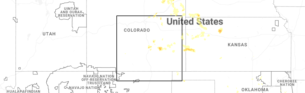
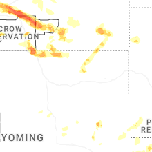
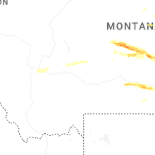
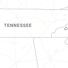
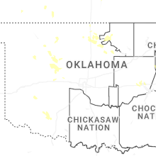
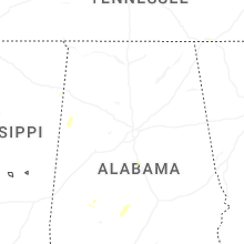
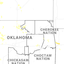
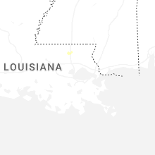
Hail Map for Friday, June 13, 2025
Number of Impacted Households on 6/13/2025
0
Impacted by 1" or Larger Hail
0
Impacted by 1.75" or Larger Hail
0
Impacted by 2.5" or Larger Hail
Square Miles of Populated Area Impacted on 6/13/2025
0
Impacted by 1" or Larger Hail
0
Impacted by 1.75" or Larger Hail
0
Impacted by 2.5" or Larger Hail

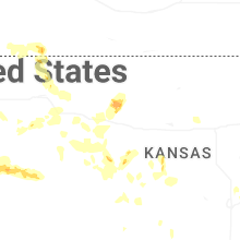
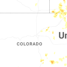
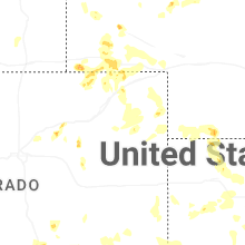
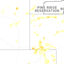
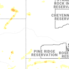
Cities Most Affected by Hail Storms of 6/13/2025
| Hail Size | Demographics of Zip Codes Affected | ||||||
|---|---|---|---|---|---|---|---|
| City | Count | Average | Largest | Pop Density | House Value | Income | Age |
| Pryor, MT | 4 | 2.44 | 2.75 | 0 | $65k | $25.0k | 31.9 |
| Harlowton, MT | 1 | 2.00 | 2.00 | 0 | $54k | $25.4k | 44.8 |
| Ryegate, MT | 1 | 2.00 | 2.00 | 0 | $51k | $29.3k | 49.9 |
| Bridgeport, NE | 1 | 1.75 | 1.75 | 2 | $50k | $30.3k | 42.9 |
| Columbus, MT | 1 | 1.75 | 1.75 | 6 | $98k | $39.4k | 44.4 |
Hail and Wind Damage Spotted on 6/13/2025
Filter by Report Type:Hail ReportsWind Reports
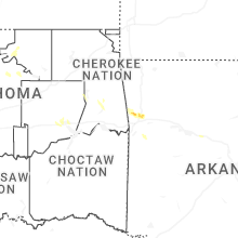
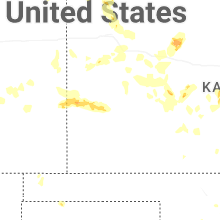
States Impacted
Oklahoma, Tennessee, Montana, Indiana, Maryland, Virginia, Wyoming, Kentucky, Nebraska, Colorado, West Virginia, Texas, South Dakota, South Carolina, New Mexico, Arkansas, KansasOklahoma
| Local Time | Report Details |
|---|---|
| 8:23 AM CDT | Asos station klaw lawto in comanche county OK, 44.5 miles N of Wichita Falls, TX |
Tennessee
| Local Time | Report Details |
|---|---|
| 1:16 PM CDT | Trees and tree limbs blown down on alfred martin rd. time estimate in wayne county TN, 33 miles NNW of Florence, AL |
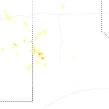
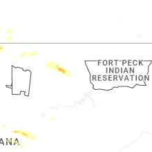
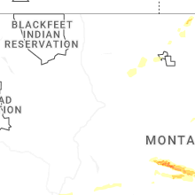
Montana
| Local Time | Report Details |
|---|---|
| 3:05 PM MDT | Em report of multiple structures with lost roofs... uprooted trees as well as tree limb damag in wheatland county MT, 77 miles NW of Billings, MT |
| 3:05 PM MDT | Hen Egg sized hail reported near Harlowton, MT, 77 miles NW of Billings, MT |
| 3:10 PM MDT | Corrects previous non-tstm wnd dmg report from harlowton. power lines down with some power outages reporte in wheatland county MT, 78.1 miles NW of Billings, MT |
| 3:20 PM MDT | Ping Pong Ball sized hail reported near Harlowton, MT, 77.7 miles NW of Billings, MT |
| 4:20 PM MDT | Hen Egg sized hail reported near Ryegate, MT, 50.5 miles NW of Billings, MT, time estimated by radar. |
| 4:20 PM MDT | Quarter (1.00 inch) hail... heavy rain and 70 mph gust... tree branches knocked down... estimated 4:20 p in petroleum county MT, 85 miles N of Billings, MT |
| 4:20 PM MDT | Quarter sized hail reported near Winnett, MT, 85 miles N of Billings, MT, quarter (1.00 inch) hail... heavy rain and 70 mph gust... tree branches knocked down... estimated 4:20 pm. |
| 6:06 PM MDT | Quarter sized hail reported near Columbus, MT, 37.3 miles WSW of Billings, MT |
| 6:10 PM MDT | Storm damage reported in yellowstone county MT, 16.7 miles NE of Billings, MT |
| 6:15 PM MDT | Half Dollar sized hail reported near Columbus, MT, 37.3 miles WSW of Billings, MT |
| 6:16 PM MDT | Tree limbs down and small objects thrown aroun in yellowstone county MT, 20.7 miles NE of Billings, MT |
| 6:20 PM MDT | Golf Ball sized hail reported near Columbus, MT, 35.7 miles WSW of Billings, MT, report from mping: golf ball (1.75 in.). |
| 6:28 PM MDT | Ping Pong Ball sized hail reported near Columbus, MT, 35.1 miles WSW of Billings, MT |
| 6:40 PM MDT | Half Dollar sized hail reported near Joliet, MT, 26.2 miles SW of Billings, MT |
| 6:45 PM MDT | Ping Pong Ball sized hail reported near Roberts, MT, 47 miles SW of Billings, MT |
| 6:48 PM MDT | Ping Pong Ball sized hail reported near Roberts, MT, 47 miles SW of Billings, MT |
| 6:52 PM MDT | Half Dollar sized hail reported near Joliet, MT, 25 miles SW of Billings, MT, report from mping: half dollar (1.25 in.). |
| 7:08 PM MDT | Tennis Ball sized hail reported near Pryor, MT, 25.2 miles S of Billings, MT |
| 7:10 PM MDT | Quarter sized hail reported near Hardin, MT, 44.2 miles E of Billings, MT |
| 7:10 PM MDT | Baseball sized hail reported near Pryor, MT, 24.5 miles S of Billings, MT |
| 7:11 PM MDT | Tennis Ball sized hail reported near Pryor, MT, 24.4 miles S of Billings, MT, report from mping: tennis ball (2.50 in.). |
| 7:15 PM MDT | Hen Egg sized hail reported near Pryor, MT, 24.5 miles S of Billings, MT |
| 8:00 PM MDT | Ping Pong Ball sized hail reported near Busby, MT, 77.2 miles ESE of Billings, MT |
Indiana
| Local Time | Report Details |
|---|---|
| 4:09 PM CDT | Multiple large trees uprooted and fallen onto home in vanderburgh county IN, 3.1 miles W of Evansville, IN |
Maryland
| Local Time | Report Details |
|---|---|
| 5:15 PM EDT | Large tree limbs blew down onto wires in beltsvill in prince georges county MD, 24.5 miles SW of Baltimore, MD |
Virginia
| Local Time | Report Details |
|---|---|
| 5:45 PM EDT | Trees blew down in the 1000 block of balsley roa in augusta county VA, 70.5 miles SE of Elkins, WV |
| 5:50 PM EDT | Trees and wires blew down blocking the 100 block of va-608 battlefield roa in augusta county VA, 71.6 miles SE of Elkins, WV |
| 5:52 PM EDT | Trees and wires blew down on forest road in page valley estate in page county VA, 77.1 miles E of Elkins, WV |
| 6:00 PM EDT | Trees blew down on va-782 north point school road in the 200 bloc in augusta county VA, 73.9 miles SE of Elkins, WV |
| 6:00 PM EDT | Corrects previous tstm wnd dmg report from 2 ese hermitage. trees blew down in the 500 block of oak grove church roa in augusta county VA, 75.3 miles SE of Elkins, WV |
| 6:00 PM EDT | Trees blew down in the 500 block of oak grove church roa in augusta county VA, 75.3 miles SE of Elkins, WV |
| 6:08 PM EDT | Trees blew down in the 800 block of va-619 hildebrand church roa in augusta county VA, 74.8 miles SE of Elkins, WV |
| 6:10 PM EDT | Trees blew down in the 600 block of va-782 brower roa in augusta county VA, 75.3 miles SE of Elkins, WV |
| 6:23 PM EDT | Trees blew down in the 600 block of sv-865 rockfish roa in augusta county VA, 77.1 miles SE of Elkins, WV |
| 6:43 PM EDT | Trees blew down in the 3600 block of va-624 lyndhurst roa in augusta county VA, 74.5 miles NE of Roanoke, VA |
| 6:44 PM EDT | Trees blew down near the intersection of va-631 ladd road and warren oaks lan in augusta county VA, 76.4 miles NE of Roanoke, VA |
| 6:45 PM EDT | Trees blew down in the unit block of blackford wa in augusta county VA, 75.3 miles NE of Roanoke, VA |
| 6:45 PM EDT | Trees blew down in the unit block of harvest roa in augusta county VA, 74.1 miles NE of Roanoke, VA |
| 6:50 PM EDT | Several greenhouses were destroyed at a nursery between lyndhurst and waynesbor in augusta county VA, 76.3 miles NE of Roanoke, VA |
| 6:55 PM EDT | Large tree limbs blew down in lyndhurs in augusta county VA, 75.8 miles NE of Roanoke, VA |
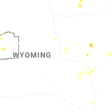
Wyoming
| Local Time | Report Details |
|---|---|
| 3:51 PM MDT | Observer reported nickel sized hail and wind gusts of 60 mp in platte county WY, 70.9 miles ESE of Casper, WY |
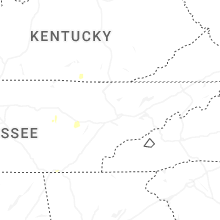
Kentucky
| Local Time | Report Details |
|---|---|
| 6:36 PM EDT | Report of a tree blocking the road near the intersection of n ky 32 and george johnson loop. multiple limbs were reported down in this general area as well. time is est in elliott county KY, 55.2 miles NE of Irvine, KY |
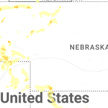
Nebraska
| Local Time | Report Details |
|---|---|
| 4:58 PM MDT | Quarter sized hail reported near Minatare, NE, 10.1 miles ESE of Scottsbluff, NE, mping report from a storm chaser via the spotter network of 1.0in hail near melbeta... ne. |
| 5:23 PM MDT | Quarter sized hail reported near Harrison, NE, 42.8 miles N of Scottsbluff, NE, trained spotter reported quarter sized hail in sioux county. |
| 5:49 PM MDT | Kneb broadcaster reported tree damage with pictures of a deciduous tree with numerous branches snapped between 3-4 inches and the largest being 6-8 inche in scotts bluff county NE, 0.6 miles NNE of Scottsbluff, NE |
| 6:37 PM MDT | Golf Ball sized hail reported near Bridgeport, NE, 37.5 miles SE of Scottsbluff, NE, public reports ping pong ball to golf ball sized hail on going. |
| 7:02 PM MDT | Quarter sized hail reported near Chadron, NE, 69.6 miles NNE of Scottsbluff, NE, trained spotter reported quarter sized hail ongoing. |
| 7:44 PM MDT | Quarter sized hail reported near Potter, NE, 47.9 miles SSE of Scottsbluff, NE, cheyenne county em reported quarter size and pea size hail in potter. |
| 9:10 PM MDT | Wind estimated 50 to 60 mp in garden county NE, 68.6 miles W of North Platte, NE |
| 9:23 PM MDT | Pws knebigsp2 in deuel county NE, 69.7 miles W of North Platte, NE |
| 9:26 PM MDT | Pws-knevenan in perkins county NE, 61.9 miles NE of Yuma, CO |
| 9:31 PM MDT | Pws-knebigsp2 in keith county NE, 66.1 miles W of North Platte, NE |
| 9:47 PM MDT | Pws-knelemoy in keith county NE, 55.3 miles W of North Platte, NE |
| 9:50 PM MDT | Koga awo in keith county NE, 52.6 miles W of North Platte, NE |
| 9:51 PM MDT | Power lines reported dow in keith county NE, 50.5 miles W of North Platte, NE |
| 9:54 PM MDT | Damage to home relayed from law enforcemen in keith county NE, 49.9 miles W of North Platte, NE |
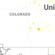
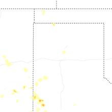
Colorado
| Local Time | Report Details |
|---|---|
| 5:35 PM MDT | Quarter sized hail reported near Fort Morgan, CO, 65.1 miles ENE of Denver, CO |
| 6:42 PM MDT | Quarter sized hail reported near Pueblo, CO, 4 miles NNW of Pueblo, CO |
| 7:05 PM MDT | Storm damage reported in washington county CO, 26.7 miles W of Yuma, CO |
| 7:25 PM MDT | Storm damage reported in washington county CO, 26.7 miles W of Yuma, CO |
West Virginia
| Local Time | Report Details |
|---|---|
| 7:35 PM EDT | Downed tree reported near artrip branch road. time estimated from rada in wayne county WV, 54 miles WSW of Charleston, WV |
| 8:01 PM EDT | Tree contact resulted in 20 customers without powe in cabell county WV, 37.7 miles W of Charleston, WV |
| 8:56 PM EDT | 4 trees down along band mill hollow r in logan county WV, 39.1 miles SSW of Charleston, WV |
| 9:25 PM EDT | Tree down on spruce laurel road. time estimated by rada in boone county WV, 28.8 miles SSW of Charleston, WV |
| 9:25 PM EDT | Tree down blocking one lane on state s in boone county WV, 21.7 miles SSW of Charleston, WV |
| 9:30 PM EDT | Tree down blocking both roadways on missouri fork r in boone county WV, 29.9 miles SSW of Charleston, WV |
| 9:51 PM EDT | Tree down on pond fork r in boone county WV, 23.9 miles SSW of Charleston, WV |
| 12:05 AM EDT | Downed tree reported on cherry fork road. time estimated from rada in upshur county WV, 30.8 miles WSW of Elkins, WV |
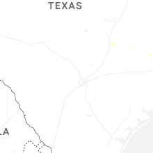
Texas
| Local Time | Report Details |
|---|---|
| 6:39 PM CDT | Ping Pong Ball sized hail reported near Levelland, TX, 42.9 miles W of Lubbock, TX, public report relayed by media. |
| 8:50 PM CDT | Storm damage reported in hockley county TX, 29.4 miles W of Lubbock, TX |
| 8:53 PM CDT | Storm damage reported in cochran county TX, 51.8 miles W of Lubbock, TX |
| 9:01 PM CDT | Storm damage reported in hockley county TX, 29.4 miles W of Lubbock, TX |
| 9:07 PM CDT | Storm damage reported in yoakum county TX, 62.1 miles WSW of Lubbock, TX |
| 9:30 PM CDT | Storm damage reported in cochran county TX, 45.7 miles WSW of Lubbock, TX |
| 9:30 PM CDT | Storm damage reported in yoakum county TX, 75.2 miles WSW of Lubbock, TX |
| 9:35 PM CDT | Storm damage reported in yoakum county TX, 71.8 miles SW of Lubbock, TX |
| 9:50 PM CDT | Storm damage reported in hockley county TX, 29.4 miles W of Lubbock, TX |
| 10:26 PM CDT | Mesonet station 96 welch dawson count in dawson county TX, 48.3 miles SSW of Lubbock, TX |
South Dakota
| Local Time | Report Details |
|---|---|
| 6:05 PM MDT | Quarter sized hail reported near Edgemont, SD, 67.3 miles SSW of Rapid City, SD |
South Carolina
| Local Time | Report Details |
|---|---|
| 8:35 PM EDT | Sumter sheriff office reported trees down in dalzell area. time estimated by rada in sumter county SC, 62.1 miles NNW of Charleston, SC |
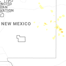
New Mexico
| Local Time | Report Details |
|---|---|
| 7:30 PM MDT | Mesonet station wsm12 stallion runway (wsmr in socorro county NM, 87.1 miles S of Albuquerque, NM |
| 8:10 PM MDT | Mesonet station wsm28 wsmr tul in otero county NM, 92.1 miles N of El Paso, TX |
| 8:25 PM MDT | Mesonet station wsm43 little burro (wsmr in socorro county NM, 102.5 miles S of Albuquerque, NM |
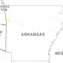
Arkansas
| Local Time | Report Details |
|---|---|
| 9:11 PM CDT | Half Dollar sized hail reported near Mountainburg, AR, 20.7 miles NE of Fort Smith, AR |
| 9:13 PM CDT | Strong thunderstorm wind blew down tree in crawford county AR, 20.5 miles NE of Fort Smith, AR |
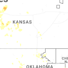
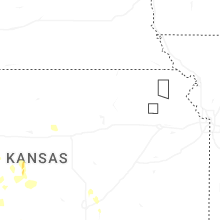
Kansas
| Local Time | Report Details |
|---|---|
| 12:38 AM CDT | Site kksoberl22 reports 59 mph wind gus in decatur county KS, 39.8 miles NNE of Colby, KS |
| 2:15 AM CDT | Koel in oakley reports 67 mph wind gus in logan county KS, 23.2 miles SSE of Colby, KS |
| 4:25 AM CDT | Storm damage reported in rooks county KS, 24.3 miles NNW of Hays, KS |
| 6:10 AM CDT | Storm damage reported in stafford county KS, 65.2 miles SSE of Hays, KS |
| 6:30 AM CDT | Storm damage reported in pratt county KS, 76.6 miles W of Wichita, KS |
Connect with Interactive Hail Maps