

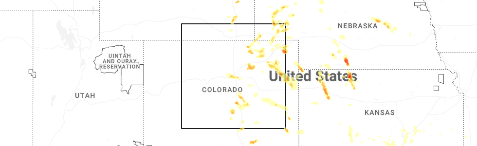
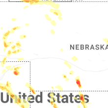
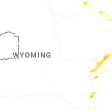
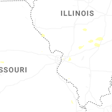
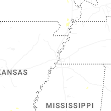
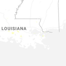
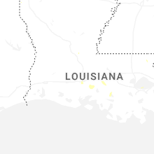
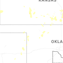
Hail Map for Sunday, July 6, 2025
Number of Impacted Households on 7/6/2025
0
Impacted by 1" or Larger Hail
0
Impacted by 1.75" or Larger Hail
0
Impacted by 2.5" or Larger Hail
Square Miles of Populated Area Impacted on 7/6/2025
0
Impacted by 1" or Larger Hail
0
Impacted by 1.75" or Larger Hail
0
Impacted by 2.5" or Larger Hail

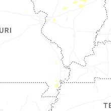

Cities Most Affected by Hail Storms of 7/6/2025
| Hail Size | Demographics of Zip Codes Affected | ||||||
|---|---|---|---|---|---|---|---|
| City | Count | Average | Largest | Pop Density | House Value | Income | Age |
| Arapahoe, NE | 2 | 2.25 | 2.75 | 6 | $45k | $29.4k | 46.4 |
| Colorado Springs, CO | 2 | 1.88 | 2.00 | 781 | $183k | $44.7k | 38.3 |
| Almena, KS | 1 | 3.00 | 3.00 | 4 | $35k | $27.5k | 43.0 |
| Manville, WY | 1 | 2.75 | 2.75 | 0 | $48k | $20.9k | 55.1 |
| Rapid City, SD | 1 | 1.75 | 1.75 | 111 | $119k | $47.4k | 44.3 |
| Scott, LA | 1 | 1.75 | 1.75 | 427 | $83k | $34.0k | 34.9 |
| Haigler, NE | 1 | 1.75 | 1.75 | 0 | $26k | $27.8k | 49.5 |
| Dalton, NE | 1 | 1.75 | 1.75 | 2 | $44k | $28.8k | 45.8 |
| Prairie View, KS | 1 | 1.75 | 1.75 | 3 | $32k | $37.3k | 44.1 |
Hail and Wind Damage Spotted on 7/6/2025
Filter by Report Type:Hail ReportsWind Reports
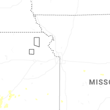
States Impacted
Missouri, Nebraska, New Mexico, Illinois, North Carolina, Louisiana, Wyoming, Michigan, Kansas, Colorado, Maine, South Dakota, Indiana, Oklahoma, TexasMissouri
| Local Time | Report Details |
|---|---|
| 2:15 PM CDT | Healthy tree branches up to 6 inches in diameter snapped off. observer said he has never seen winds this strong befor in moniteau county MO, 25.6 miles SSW of Columbia, MO |
| 2:17 PM CDT | Time estimated from rada in moniteau county MO, 26.2 miles SSW of Columbia, MO |
| 3:00 PM CDT | 58 to 60 mph wind gusts measured on home weather station. also reported penny size hai in vernon county MO, 59.8 miles ENE of Chanute, KS |
| 3:00 PM CDT | 2-3 inch diameter branches dow in vernon county MO, 60.8 miles E of Chanute, KS |
| 3:25 PM CDT | Large tree limbs down on parkwood driv in st. charles county MO, 24.5 miles WNW of Saint Louis, MO |
| 3:30 PM CDT | Power pole down at clemens dr and dawson. time estimated from rada in st. charles county MO, 22 miles WNW of Saint Louis, MO |
| 3:30 PM CDT | Several trees down at the sunbrook apartment comple in st. charles county MO, 22.8 miles WNW of Saint Louis, MO |
| 3:30 PM CDT | Webster county emergency manager estimated gusts up to 60 mph. time estimated from rada in webster county MO, 22.9 miles ENE of Springfield, MO |
| 3:50 PM CDT | Large tree down blocking the road at hwy 124 and barnes school roa in boone county MO, 12.1 miles NNE of Columbia, MO |
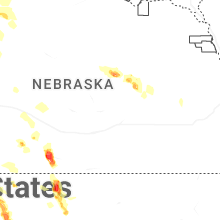
Nebraska
| Local Time | Report Details |
|---|---|
| 2:17 PM CDT | Personal weather station reports gust to 69mp in nance county NE, 41.4 miles NNE of Grand Island, NE |
| 2:19 PM CDT | Measured gust from public mesonet statio in boone county NE, 42.5 miles NNE of Grand Island, NE |
| 3:10 PM CDT | Baseball sized hail reported near Arapahoe, NE, 71.8 miles SE of North Platte, NE, reports from this spotter between holbrook of hail between golf ball and baseball size hail and wind gusts of 60 to 65 mph. first report of large hail was approx 305pm. |
| 3:28 PM CDT | Golf Ball sized hail reported near Arapahoe, NE, 78.1 miles SE of North Platte, NE, ping pong ball to golf ball size hail reported. hail covering the road. visibility near zero due to heavy rain. |
| 3:43 PM CDT | Ping Pong Ball sized hail reported near Beaver City, NE, 84.2 miles NE of Colby, KS |
| 5:53 PM MDT | Upr site near brownson gusted 58 mph during a thunderstor in cheyenne county NE, 54 miles SSE of Scottsbluff, NE |
| 6:35 PM MDT | Golf Ball sized hail reported near Dalton, NE, 50 miles ESE of Scottsbluff, NE, trained spotter reports golf ball size hail. |
| 6:44 PM MDT | Ping Pong Ball sized hail reported near Haigler, NE, 42.2 miles E of Yuma, CO, trained spotter reports hail ranging from 1 to 1.5 inches in size. |
| 6:49 PM MDT | Golf Ball sized hail reported near Haigler, NE, 42.2 miles E of Yuma, CO, report from mping: golf ball (1.75 in.). |
| 6:57 PM MDT | Quarter sized hail reported near Broadwater, NE, 55.3 miles ESE of Scottsbluff, NE, trained spotter reports quarter size hail. |
| 6:57 PM MDT | Trained spotter reports crop damage due to wind and a 6 inch diameter tree blown ove in morrill county NE, 55.3 miles ESE of Scottsbluff, NE |
| 7:03 PM MDT | Quarter sized hail reported near Lisco, NE, 53.3 miles ESE of Scottsbluff, NE, report from mping: quarter (1.00 in.). |
| 7:12 PM MDT | Half Dollar sized hail reported near Bayard, NE, 17.8 miles E of Scottsbluff, NE, trained spotter reports half dollar size hail. |
| 7:38 PM MDT | Quarter sized hail reported near Alliance, NE, 34.4 miles ENE of Scottsbluff, NE, report from mping: quarter (1.00 in.). |
| 7:55 PM MDT | Half Dollar sized hail reported near Alliance, NE, 48.6 miles ENE of Scottsbluff, NE, report from mping: half dollar (1.25 in.). |
| 8:01 PM MDT | Ping Pong Ball sized hail reported near Alliance, NE, 48.6 miles ENE of Scottsbluff, NE, report from mping: ping pong ball (1.50 in.). |
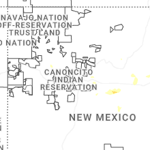
New Mexico
| Local Time | Report Details |
|---|---|
| 1:20 PM MDT | Quarter sized hail reported near Sandia Park, NM, 20.4 miles ENE of Albuquerque, NM |
| 1:33 PM MDT | Quarter sized hail reported near Sandia Park, NM, 20.8 miles ENE of Albuquerque, NM, report from mping: quarter (1.00 in.). |
| 1:35 PM MDT | Quarter sized hail reported near Cedar Crest, NM, 17 miles ENE of Albuquerque, NM |
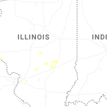
Illinois
| Local Time | Report Details |
|---|---|
| 2:57 PM CDT | Tree downed onto wires by thunderstorm wind in shelby county IL, 22.7 miles WSW of Mattoon, IL |
| 3:50 PM CDT | Tree down on home. relayed via broadcast medi in coles county IL, 0.8 miles W of Mattoon, IL |
| 4:15 PM CDT | Mostly small limbs down and a medium sized branch. time estimated from rada in monroe county IL, 18.1 miles S of Saint Louis, MO |
| 4:40 PM CDT | Large tree down across route in st. clair county IL, 21.2 miles E of Saint Louis, MO |
| 5:34 PM CDT | Multiple trees down on power lines. time estimated from rada in montgomery county IL, 50.5 miles WSW of Mattoon, IL |
| 6:32 PM CDT | Swop report. storm tota in coles county IL, 10.5 miles E of Mattoon, IL |
North Carolina
| Local Time | Report Details |
|---|---|
| 4:10 PM EDT | Multiple large trees down near high park. time estimate in orange county NC, 24.5 miles WNW of Raleigh, NC |
Louisiana
| Local Time | Report Details |
|---|---|
| 4:02 PM CDT | Golf Ball sized hail reported near Scott, LA, 4.6 miles WNW of Lafayette, LA, scott pd reported golf ball size hail in city limits. |
| 4:02 PM CDT | Tree down wilbourn and ambassado in lafayette county LA, 3.8 miles W of Lafayette, LA |
| 4:07 PM CDT | Quarter sized hail reported near Lafayette, LA, 2.6 miles W of Lafayette, LA, video of hail falling on a car driving on eraste landry rd. |
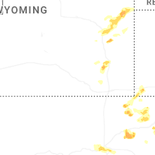
Wyoming
| Local Time | Report Details |
|---|---|
| 3:18 PM MDT | Wydot sensor on interstate 80 at mile post 353 gusted 58 mph as a line of storms moved throug in laramie county WY, 35.2 miles ESE of Laramie, WY |
| 3:58 PM MDT | Cwop station fw7016 recorded 58 mph wind gust with stor in laramie county WY, 59.6 miles SW of Scottsbluff, NE |
| 4:05 PM MDT | Upr site near hillsdale gusted 65 mph with stor in laramie county WY, 59.3 miles E of Laramie, WY |
| 4:16 PM MDT | Video from public on social media shows significant and sustained blowing dust from a thunderstorm. visibility was reduce in laramie county WY, 57.8 miles SSW of Scottsbluff, NE |
| 5:00 PM MDT | Ping Pong Ball sized hail reported near Guernsey, WY, 65.6 miles WNW of Scottsbluff, NE, picture from social media showing ping pong ball size hail at guernsey state park. |
| 6:10 PM MDT | Baseball sized hail reported near Manville, WY, 80.1 miles NW of Scottsbluff, NE, emergency manager reports baseball size hail. multiple reports of broken windows in homes and vehicles. |
| 6:43 PM MDT | Quarter sized hail reported near Lusk, WY, 85.2 miles NNW of Scottsbluff, NE, emergency manager reports quarter size hail. |
| 12:49 AM MDT | Quarter sized hail reported near Upton, WY, 42.7 miles E of Gillette, WY |
Michigan
| Local Time | Report Details |
|---|---|
| 5:20 PM EDT | Multiple trees down on powerlines near intersection of hockaday rd and armchester dr. report relayed by gladwin county em. time estimated via rada in gladwin county MI, 73 miles SE of Traverse City, MI |
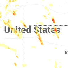
Kansas
| Local Time | Report Details |
|---|---|
| 4:33 PM CDT | Quarter sized hail reported near El Dorado, KS, 31.5 miles ENE of Wichita, KS, nickel and quarter sized hail reported. |
| 4:35 PM CDT | Storm damage reported in butler county KS, 29 miles ENE of Wichita, KS |
| 4:35 PM CDT | Golf Ball sized hail reported near Prairie View, KS, 69.7 miles NNW of Hays, KS, delayed entry. text report of golf ball sized hail. |
| 4:37 PM CDT | Estimated 60-65 mp in butler county KS, 27.6 miles ENE of Wichita, KS |
| 4:40 PM CDT | 6 to 8 inch diameter tree limbs dow in butler county KS, 27.6 miles ENE of Wichita, KS |
| 4:48 PM CDT | Tea Cup sized hail reported near Almena, KS, 67.4 miles NNW of Hays, KS, trained spotter reports hail up to 3 inches. damage to north facing windows. |
| 4:50 PM CDT | Numerous limbs reported down in the southeast part of el dorad in butler county KS, 27.9 miles ENE of Wichita, KS |
| 4:55 PM CDT | Storm damage reported in butler county KS, 28.8 miles ENE of Wichita, KS |
| 5:02 PM CDT | Quarter sized hail reported near Atwood, KS, 30.9 miles N of Colby, KS, trained spotter reports one inch hail. |
| 5:14 PM CDT | Estimated 50-60 mph gust in sedgwick county KS, 9.2 miles SE of Wichita, KS |
| 5:20 PM CDT | Quarter sized hail reported near Atwood, KS, 33.4 miles N of Colby, KS |
| 5:24 PM CDT | Accuweather meteorologis in sedgwick county KS, 10.2 miles SSE of Wichita, KS |
| 5:28 PM CDT | Four inch diameter maple branch broken of in sedgwick county KS, 7.8 miles N of Wichita, KS |
| 5:29 PM CDT | Estimated 60-6 in sedgwick county KS, 9.9 miles SSE of Wichita, KS |
| 5:48 PM CDT | Site khlc reports 59 mph wind gus in graham county KS, 44.1 miles NW of Hays, KS |
| 5:49 PM CDT | 50-60 mp in harper county KS, 36.2 miles SW of Wichita, KS |
| 5:53 PM CDT | Limbs dow in harper county KS, 41 miles SW of Wichita, KS |
| 6:30 PM CDT | Quarter sized hail reported near Gem, KS, 7.3 miles E of Colby, KS, report from mping: quarter (1.00 in.). |
| 6:35 PM CDT | Keg in sumner county KS, 25.5 miles S of Wichita, KS |
| 6:59 PM CDT | Chaser estimated 60 mph wind gust with near zero visibility in rai in thomas county KS, 11.9 miles SE of Colby, KS |
| 7:07 PM CDT | Reported via ambient weather station dog_hous in logan county KS, 21.2 miles SSE of Colby, KS |
| 7:09 PM CDT | Quarter sized hail reported near Oakley, KS, 14.3 miles SE of Colby, KS, chaser sent in picture of quarter sized hail... 8 miles north of oakley. |
| 7:10 PM CDT | Spotter reports 2 inch green tree limb down in oakley. time estimated from rada in logan county KS, 21.2 miles SSE of Colby, KS |
| 7:12 PM CDT | Koel measured 62 mph wind gus in logan county KS, 23.2 miles SSE of Colby, KS |
| 7:14 PM CDT | Very heavy rain and estimated wind gusts to around 60 mp in sumner county KS, 46.9 miles S of Wichita, KS |
| 9:05 PM CDT | Storm damage reported in ford county KS, 62.7 miles ESE of Garden City, KS |
| 9:06 PM CDT | Sizeable tree limb dow in ford county KS, 63.6 miles ESE of Garden City, KS |
| 9:40 PM MDT | Asos station kgld goodlan in sherman county KS, 35.1 miles W of Colby, KS |
| 9:40 PM MDT | Site kksweska9 measured 72 mph wind gus in wallace county KS, 58.9 miles WSW of Colby, KS |
| 9:58 PM MDT | Delayed entry. ksn storm chaser measured 82 mph wind gust at mm 28 on i-7 in sherman county KS, 25.9 miles W of Colby, KS |
| 10:06 PM MDT | Site wallace on ks mesonet measured 59 mph wind gus in wallace county KS, 59.2 miles SW of Colby, KS |
| 10:15 PM MDT | Kansas mesonet site reports a 2m wind of 59 mp in greeley county KS, 60.2 miles NW of Garden City, KS |
| 10:24 PM MDT | Cw609 in wallace county KS, 55.1 miles SW of Colby, KS |
| 11:54 PM CDT | Kansas mesonet site reports a 60 mph wind gus in wichita county KS, 43.1 miles NW of Garden City, KS |
| 11:56 PM CDT | Kansas mesonet site reports the gus in wichita county KS, 43.1 miles NW of Garden City, KS |
| 12:01 AM CDT | Ambient weather site leesimons_farms_ reports the gus in wichita county KS, 44.9 miles NNW of Garden City, KS |
| 12:35 AM CDT | Storm damage reported in scott county KS, 27.6 miles N of Garden City, KS |
| 12:40 AM CDT | Storm damage reported in kearny county KS, 18.9 miles W of Garden City, KS |
| 12:41 AM CDT | Storm damage reported in finney county KS, 18.9 miles NNW of Garden City, KS |
| 12:47 AM CDT | Storm damage reported in kearny county KS, 14.3 miles WSW of Garden City, KS |
| 1:00 AM CDT | Storm damage reported in finney county KS, 3.2 miles ENE of Garden City, KS |
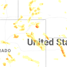
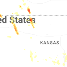
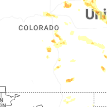
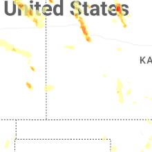
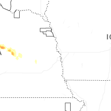
Colorado
| Local Time | Report Details |
|---|---|
| 3:40 PM MDT | Quarter sized hail reported near Haxtun, CO, 42.2 miles N of Yuma, CO |
| 4:54 PM MDT | Ping Pong Ball sized hail reported near Briggsdale, CO, 74 miles NNE of Denver, CO, report from mping: ping pong ball (1.50 in.). |
| 5:05 PM MDT | Quarter sized hail reported near Colorado Springs, CO, 46.5 miles SSE of Denver, CO |
| 5:06 PM MDT | Quarter sized hail reported near Manitou Springs, CO, 43.3 miles NNW of Pueblo, CO |
| 5:07 PM MDT | Quarter sized hail reported near Colorado Springs, CO, 40.3 miles NNW of Pueblo, CO |
| 5:13 PM MDT | Half Dollar sized hail reported near Colorado Springs, CO, 41.7 miles NNW of Pueblo, CO, report from mping: half dollar (1.25 in.). |
| 5:20 PM MDT | Ping Pong Ball sized hail reported near Colorado Springs, CO, 40.8 miles NNW of Pueblo, CO, storm lasted for 40 minutes (520pm-6pm) with largest hail 1.5 inches. 1.85 inches rain and melted hail. |
| 5:28 PM MDT | Quarter sized hail reported near Colorado Springs, CO, 39 miles NNW of Pueblo, CO, report from mping: quarter (1.00 in.). |
| 5:30 PM MDT | Golf Ball sized hail reported near Colorado Springs, CO, 41 miles NNW of Pueblo, CO |
| 5:34 PM MDT | Half Dollar sized hail reported near Colorado Springs, CO, 48.6 miles SSE of Denver, CO, report from mping: half dollar (1.25 in.). |
| 5:35 PM MDT | Ping Pong Ball sized hail reported near Colorado Springs, CO, 41.7 miles NNW of Pueblo, CO |
| 5:40 PM MDT | Quarter sized hail reported near Colorado Springs, CO, 51.6 miles N of Pueblo, CO, report from mping: quarter (1.00 in.). |
| 5:43 PM MDT | Hen Egg sized hail reported near Colorado Springs, CO, 39.2 miles NNW of Pueblo, CO |
| 5:50 PM MDT | Half Dollar sized hail reported near Colorado Springs, CO, 52.1 miles SSE of Denver, CO |
| 5:50 PM MDT | Quarter sized hail reported near Colorado Springs, CO, 33.1 miles N of Pueblo, CO, report from mping: quarter (1.00 in.). |
| 5:51 PM MDT | Half Dollar sized hail reported near Colorado Springs, CO, 50.2 miles N of Pueblo, CO, report from mping: half dollar (1.25 in.). |
| 5:56 PM MDT | Quarter sized hail reported near Peyton, CO, 49.4 miles N of Pueblo, CO, report from mping: quarter (1.00 in.). |
| 6:00 PM MDT | Ping Pong Ball sized hail reported near Colorado Springs, CO, 39 miles NNW of Pueblo, CO, measured 1.5 inch hail. widespread window damage and broken skylights reported. hail fell for approximately 40 consecutive minutes. |
| 6:03 PM MDT | Quarter sized hail reported near Colorado Springs, CO, 36.9 miles NNW of Pueblo, CO |
| 6:07 PM MDT | Quarter sized hail reported near Peyton, CO, 47.4 miles N of Pueblo, CO, report from mping: quarter (1.00 in.). |
| 6:10 PM MDT | Quarter sized hail reported near Peyton, CO, 48.7 miles N of Pueblo, CO |
| 6:11 PM MDT | Ping Pong Ball sized hail reported near Peyton, CO, 45.9 miles N of Pueblo, CO |
| 6:31 PM MDT | Quarter sized hail reported near Denver, CO, 8 miles W of Denver, CO, report from mping: quarter (1.00 in.). |
| 6:39 PM MDT | Awos station kako akro in washington county CO, 26.6 miles W of Yuma, CO |
| 6:46 PM MDT | Ping Pong Ball sized hail reported near Denver, CO, 3.7 miles W of Denver, CO, report from mping: ping pong ball (1.50 in.). |
| 6:58 PM MDT | Quarter sized hail reported near Denver, CO, 3.8 miles E of Denver, CO |
| 7:16 PM MDT | Quarter sized hail reported near Aurora, CO, 8.4 miles ESE of Denver, CO |
| 8:20 PM MDT | Mesonet station krk01 3 e joes in yuma county CO, 32.1 miles S of Yuma, CO |
| 8:29 PM MDT | Mesonet station up729 0.5 w kit carson (upr in cheyenne county CO, 93.8 miles S of Yuma, CO |
| 9:06 PM MDT | Kitr measured 67 mph wind gus in kit carson county CO, 65 miles SSE of Yuma, CO |
Maine
| Local Time | Report Details |
|---|---|
| 6:48 PM EDT | Corrects previous lightning report from 3 ne danforth. report on social media of lakeside homes and camps with trees down on or around them on east grand lake. time est in aroostook county ME, 76.6 miles NE of Bangor, ME |
| 7:19 PM EDT | Tree down... no power lines involve in penobscot county ME, 18.7 miles NW of Bangor, ME |
| 7:21 PM EDT | Lightning strike. tree fell on vehicle and down on exeter road with wires dow in penobscot county ME, 22.4 miles WNW of Bangor, ME |
| 7:22 PM EDT | Burning tree on wires at pinkham drive and darling road in hudso in penobscot county ME, 13.2 miles NNW of Bangor, ME |
| 7:27 PM EDT | Tree down in road on old town road... near rogers marke in penobscot county ME, 14.9 miles NNW of Bangor, ME |
| 7:58 PM EDT | Tree on power lines on exeter roa in penobscot county ME, 24.8 miles NW of Bangor, ME |
| 8:03 PM EDT | Low hanging wires and trees down on greenfield roa in penobscot county ME, 16.8 miles NNE of Bangor, ME |
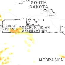
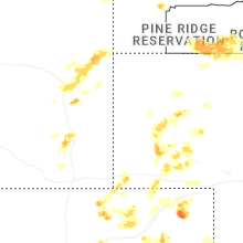
South Dakota
| Local Time | Report Details |
|---|---|
| 5:30 PM MDT | Golf Ball sized hail reported near Rapid City, SD, 7 miles SW of Rapid City, SD |
| 5:31 PM MDT | Quarter sized hail reported near Rapid City, SD, 3.6 miles SW of Rapid City, SD |
| 5:40 PM MDT | Storm damage reported in pennington county SD, 9.1 miles SSW of Rapid City, SD |
| 5:42 PM MDT | Quarter sized hail reported near Rapid City, SD, 5.1 miles SW of Rapid City, SD, mping report |
| 5:45 PM MDT | Quarter sized hail reported near Rapid City, SD, 4.2 miles S of Rapid City, SD |
| 6:11 PM MDT | Quarter sized hail reported near Hermosa, SD, 16.7 miles S of Rapid City, SD |
Indiana
| Local Time | Report Details |
|---|---|
| 7:50 PM EDT | Trees down onto powerlines near the intersection of 150 e and 300 s on the south side of logansport. time estimated via radar. a 47 mph gust was recorded nearby at the in cass county IN, 65.9 miles N of Indianapolis, IN |
Oklahoma
| Local Time | Report Details |
|---|---|
| 3:20 AM CDT | Storm damage reported in texas county OK, 79 miles SSW of Garden City, KS |
Texas
| Local Time | Report Details |
|---|---|
| 5:10 AM CDT | Storm damage reported in donley county TX, 53.1 miles NW of Childress, TX |
Connect with Interactive Hail Maps