

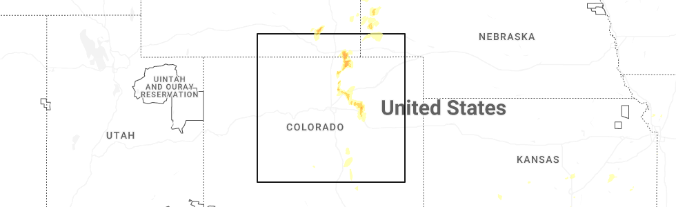
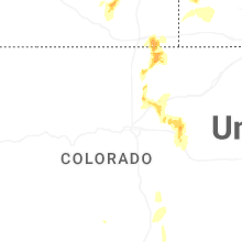
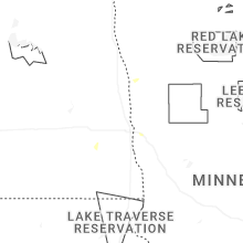
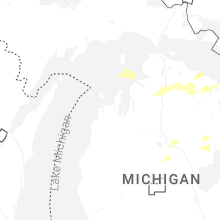
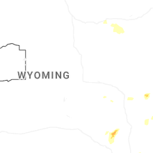
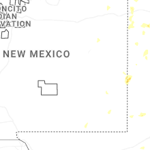
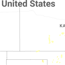
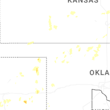
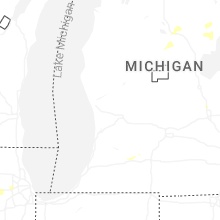
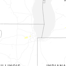
Hail Map for Thursday, July 24, 2025
Number of Impacted Households on 7/24/2025
0
Impacted by 1" or Larger Hail
0
Impacted by 1.75" or Larger Hail
0
Impacted by 2.5" or Larger Hail
Square Miles of Populated Area Impacted on 7/24/2025
0
Impacted by 1" or Larger Hail
0
Impacted by 1.75" or Larger Hail
0
Impacted by 2.5" or Larger Hail


Cities Most Affected by Hail Storms of 7/24/2025
| Hail Size | Demographics of Zip Codes Affected | ||||||
|---|---|---|---|---|---|---|---|
| City | Count | Average | Largest | Pop Density | House Value | Income | Age |
Hail and Wind Damage Spotted on 7/24/2025
Filter by Report Type:Hail ReportsWind Reports
States Impacted
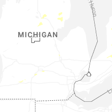
Michigan, Illinois, Indiana, Texas, New Mexico, Colorado, Nevada, Louisiana, Nebraska, California, Oklahoma, KansasMichigan
| Local Time | Report Details |
|---|---|
| 11:35 AM EDT | Numerous trees down on road with visible funnel reported. potential tornado damage. time estimated via rada in cheboygan county MI, 60.6 miles SSW of Sault Sainte Marie, MI |
| 2:01 PM EDT | Emergency manager relayed a report from the public of numerous trees down and a roof ripped off a silo. delayed report... time estimated via rada in grand traverse county MI, 3.3 miles SSE of Traverse City, MI |
| 2:18 PM EDT | Powerline and trees reported dow in gladwin county MI, 68.1 miles SE of Traverse City, MI |
| 2:18 PM EDT | Emergency manager reports trees down on powerlines northwest of gladwi in gladwin county MI, 72 miles SE of Traverse City, MI |
| 2:20 PM EDT | Trees reported dow in gladwin county MI, 68.7 miles SE of Traverse City, MI |
| 2:28 PM EDT | Emergency manager reported tree on powerline which fell on a ca in gladwin county MI, 77.1 miles NNW of Flint, MI |
| 2:30 PM EDT | A few trees and power lines dow in isabella county MI, 64 miles NE of Grand Rapids, MI |
| 2:40 PM EDT | Emergency manager reported multiple trees down blocking roads in moffatt twp on maple ridge rd near m-33. also noted trees down across other parts of arenac and ogemaw in arenac county MI, 72 miles SSW of Alpena, MI |
| 3:10 PM EDT | Trained spotter reports large uprooted tree down on railroad crossing at cody estes rd. two additional large limbs down on east mt forest rd and elevator r in bay county MI, 60.8 miles NNW of Flint, MI |
| 3:15 PM EDT | Mesonet station xtaw tawas poin in iosco county MI, 56 miles S of Alpena, MI |
| 3:40 PM EDT | Measurement from gravelly shoal light in lhz421 county MI, 70.1 miles N of Flint, MI |
| 3:55 PM EDT | Dispatch reports numerous trees and power lines down in the caseville area near the crossroads of conkey and sand r in huron county MI, 67.5 miles NNE of Flint, MI |
| 4:40 PM EDT | Dispatch reports multiple trees and power lines down in the harbor beach are in huron county MI, 77.9 miles NE of Flint, MI |
| 5:30 PM EDT | Mesonet station 45026 4 nw bridgma in lmz043 county MI, 52.6 miles E of Chicago, IL |
| 5:55 PM EDT | Trees down on m-96 blocking traffic between galesburg and augusta. time estimated from radar and power outage ma in kalamazoo county MI, 47.5 miles SSE of Grand Rapids, MI |
| 6:24 PM EDT | Dispatch reports numerous trees and power lines down near millington. photo on social media of large tree uprooted in millington as wel in tuscola county MI, 20.2 miles NNE of Flint, MI |
| 6:41 PM EDT | Dispatch reports numerous trees and power lines down across the county. hardest hit areas were lapeer... attica... and north of imlay city. dispatch received multiple r in lapeer county MI, 29.3 miles E of Flint, MI |
| 8:15 PM EDT | A large tree was blown down in royal oa in oakland county MI, 44 miles SE of Flint, MI |
| 8:38 PM EDT | Amateur radio reports 60 mph wind gust measured at gratiot ave and metro parkwa in macomb county MI, 50.6 miles SE of Flint, MI |
Illinois
| Local Time | Report Details |
|---|---|
| 2:24 PM CDT | Large tree branches and limbs downed in oswego. time estimated from rada in kendall county IL, 39.4 miles WSW of Chicago, IL |
| 2:25 PM CDT | Numerous wires dow in kane county IL, 37.1 miles WSW of Chicago, IL |
| 2:26 PM CDT | Storm damage reported in kane county IL, 40.2 miles WSW of Chicago, IL |
| 2:28 PM CDT | Multiple reports of trees and wires downed across auror in kane county IL, 34.7 miles WSW of Chicago, IL |
| 2:28 PM CDT | Tree downed onto a house. time estimated from rada in kane county IL, 35.1 miles W of Chicago, IL |
| 2:28 PM CDT | Multiple trees downed on the east side of north aurora. time estimated from rada in kane county IL, 35.2 miles W of Chicago, IL |
| 2:35 PM CDT | Tree downed on the south side of yorkville. time estimated from rada in kendall county IL, 45.7 miles WSW of Chicago, IL |
| 2:37 PM CDT | Multiple public reports of downed trees and large tree limbs on the south side of naperville. time estimated from rada in dupage county IL, 28.3 miles WSW of Chicago, IL |
| 2:38 PM CDT | Trees and wires down near naper blvd and collingwood driv in dupage county IL, 26.1 miles WSW of Chicago, IL |
| 2:38 PM CDT | Photo showed a large oak tree down in front yar in will county IL, 27.3 miles WSW of Chicago, IL |
| 2:38 PM CDT | Numerous trees and wires down in the vicinity. relayed via the city of napervill in dupage county IL, 27.7 miles WSW of Chicago, IL |
| 2:43 PM CDT | Power poles snappe in will county IL, 29.3 miles WSW of Chicago, IL |
| 2:44 PM CDT | Estimated 65 mph wind gusts. numerous 3 to 6 inch diameter tree limbs dow in dupage county IL, 22.7 miles WSW of Chicago, IL |
| 2:44 PM CDT | Large tree downed at the white fence farm restaurant. time estimated from rada in will county IL, 26.6 miles WSW of Chicago, IL |
| 2:44 PM CDT | Tree branch greater than 6 inches in diameter downed in a front yard on north pinecrest road. time estimated from rada in will county IL, 25 miles WSW of Chicago, IL |
| 2:44 PM CDT | Power lines and large tree branches downed in woodridge. damage to gutters and siding reported as wel in dupage county IL, 23 miles WSW of Chicago, IL |
| 2:45 PM CDT | 12 inch diameter tree limb downed at oldfield road and lemont roa in dupage county IL, 22.2 miles WSW of Chicago, IL |
| 2:45 PM CDT | Wires down and tree down in the roa in cook county IL, 24.1 miles SW of Chicago, IL |
| 2:46 PM CDT | Photo shared of a large tree limb snapped. time estimated from rada in dupage county IL, 20.1 miles WSW of Chicago, IL |
| 2:46 PM CDT | Video received showing numerous tree branches of various sizes down near the intersection of short street and main street in lisl in dupage county IL, 23.5 miles WSW of Chicago, IL |
| 2:48 PM CDT | Photo shared of rotted tree downed onto street. time estimated from rada in dupage county IL, 19.4 miles WSW of Chicago, IL |
| 2:49 PM CDT | Photo shared on social media of approximately 3 inch diameter tree branches downed at route 83 and 63rd street. time estimated from rada in dupage county IL, 18.2 miles WSW of Chicago, IL |
| 2:52 PM CDT | Photos submitted of trees with large branches snapped. time estimated by rada in dupage county IL, 16.4 miles WSW of Chicago, IL |
| 2:54 PM CDT | Large tree branches downe in cook county IL, 14.8 miles WSW of Chicago, IL |
| 2:54 PM CDT | One foot diameter tree limb down onto a power lin in cook county IL, 13.1 miles WSW of Chicago, IL |
| 2:55 PM CDT | Tree blown down. time estimated from rada in cook county IL, 16.6 miles SW of Chicago, IL |
| 2:55 PM CDT | Multiple reports of large tree limbs downed in la grange. time estimated from rada in cook county IL, 13.3 miles WSW of Chicago, IL |
| 2:58 PM CDT | Multiple 12 inch diameter trees snappe in cook county IL, 8.7 miles WSW of Chicago, IL |
| 3:00 PM CDT | Storm damage reported in cook county IL, 12.5 miles SW of Chicago, IL |
| 3:00 PM CDT | Storm damage reported in cook county IL, 13.4 miles SSW of Chicago, IL |
| 3:01 PM CDT | 2 inch diameter tree limbs also broke in cook county IL, 12.9 miles SSW of Chicago, IL |
| 3:02 PM CDT | Measured at the midway aso in cook county IL, 9.2 miles SW of Chicago, IL |
| 3:04 PM CDT | Tree down on hous in cook county IL, 8.8 miles SSW of Chicago, IL |
| 3:12 PM CDT | Measured at a personal weather statio in cook county IL, 6.9 miles SSE of Chicago, IL |
| 3:26 PM CDT | Fence partially blown down and two fence posts snappe in will county IL, 35.3 miles SW of Chicago, IL |
| 3:33 PM CDT | Photo relayed of downed tree in romeoville on il-53 near bluff road that landed on a fence as well as the south bound lane of the road. time estimated by rada in will county IL, 26.2 miles WSW of Chicago, IL |
Indiana
| Local Time | Report Details |
|---|---|
| 3:34 PM CDT | Gyy awo in lake county IN, 22.1 miles SSE of Chicago, IL |
| 4:00 PM CDT | Measured on a personal weather statio in porter county IN, 35.8 miles ESE of Chicago, IL |
| 7:06 PM EDT | Trees down around lake pleasant. some smaller structures damaged as wel in steuben county IN, 46.5 miles N of Fort Wayne, IN |
| 7:12 PM EDT | Outflow wind from thunderstorms downed an estimated 36 inch diameter tree. tree did have a hollow spot on the insid in steuben county IN, 42 miles NNE of Fort Wayne, IN |
| 7:17 PM EDT | Trees down in the area of sr120 and 700 e from thunderstorm outflow win in steuben county IN, 46.8 miles NNE of Fort Wayne, IN |
Texas
| Local Time | Report Details |
|---|---|
| 4:12 PM CDT | Storm damage reported in jeff davis county TX, 45 miles NNW of Alpine, TX |
| 6:33 PM CDT | Storm damage reported in bailey county TX, 66.3 miles NW of Lubbock, TX |
| 7:26 PM CDT | Photos received of straight line wind damage to outdoor awning. an outdoor wooden table was flipped and tree debris was noted in the area. time estimated by rada in jasper county TX, 20.6 miles WNW of Beaumont, TX |
| 7:29 PM CDT | Ping Pong Ball sized hail reported near Clarendon, TX, 53.1 miles ESE of Amarillo, TX, report from mping: ping pong ball (1.50 in.). |
| 10:10 PM CDT | Storm damage reported in cottle county TX, 38.7 miles SSW of Childress, TX |
| 10:11 PM CDT | Storm damage reported in cottle county TX, 38.7 miles SSW of Childress, TX |
| 10:40 PM CDT | Storm damage reported in randall county TX, 7 miles SSE of Amarillo, TX |
New Mexico
| Local Time | Report Details |
|---|---|
| 3:49 PM MDT | Quarter sized hail reported near Taiban, NM, 53.3 miles SSW of Tucumcari, NM, quarter sized hail reported. |
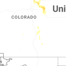
Colorado
| Local Time | Report Details |
|---|---|
| 3:57 PM MDT | Quarter sized hail reported near Greeley, CO, 44.2 miles NNE of Denver, CO, average size 0.5 inches... lasted a duration of 12 minutes. |
| 4:02 PM MDT | Half Dollar sized hail reported near Greeley, CO, 48.4 miles NNE of Denver, CO, report via social media. |
| 4:04 PM MDT | Quarter sized hail reported near Greeley, CO, 47.6 miles NNE of Denver, CO, report from mping: quarter (1.00 in.). |
| 4:04 PM MDT | Quarter sized hail reported near Greeley, CO, 48.1 miles NNE of Denver, CO, report from mping: quarter (1.00 in.). |
| 4:19 PM MDT | Quarter sized hail reported near Greeley, CO, 48.6 miles NNE of Denver, CO, report via spotternetwork. time estimated by radar. |
| 4:34 PM MDT | Mesonet station co038 i-76 keenesburg/hudso in weld county CO, 34 miles NE of Denver, CO |
| 4:36 PM MDT | Quarter sized hail reported near Keenesburg, CO, 34.9 miles NE of Denver, CO, report of penny to quarter size hail on the southwest side of keenesburg. report via social media. |
| 4:54 PM MDT | Weatherlink station wl-prospect valley2.52n in weld county CO, 40.9 miles NE of Denver, CO |
| 5:26 PM MDT | Mesonet station co222 dearfiel in weld county CO, 54.3 miles NE of Denver, CO |
| 5:39 PM MDT | Pws-kcowiggi1 in morgan county CO, 58.2 miles NE of Denver, CO |
| 5:56 PM MDT | Pws-kcobyers1 in adams county CO, 48.6 miles ENE of Denver, CO |
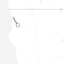
Nevada
| Local Time | Report Details |
|---|---|
| 3:44 PM PDT | Mesonet station up973 3.9 sw gerlach (upr in washoe county NV, 78.4 miles NNE of Reno, NV |
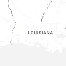
Louisiana
| Local Time | Report Details |
|---|---|
| 6:08 PM CDT | Photos received via social media of thunderstorm damage at the jellystone rv park. tree was snapped off approximately 5 feet up the trunk and fell onto an rv. time esti in calcasieu county LA, 37.4 miles ENE of Beaumont, TX |
| 6:12 PM CDT | Received photo of tree snapped about 8 feet off the groun in calcasieu county LA, 34.6 miles ENE of Beaumont, TX |
| 6:16 PM CDT | Asos station klch lake charle in calcasieu county LA, 31 miles E of Beaumont, TX |
Nebraska
| Local Time | Report Details |
|---|---|
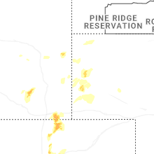
| 5:25 PM MDT | Spotter recorded 62 mph wind gust on personal weather station. strong winds blew down their flag pole. pea to half inch hail was also occuring at the tim in scotts bluff county NE, 6.6 miles SW of Scottsbluff, NE |
| 5:39 PM MDT | Spotter reports 75 mph wind gust with kestrel wind mete in scotts bluff county NE, 8.6 miles SE of Scottsbluff, NE |
California
| Local Time | Report Details |
|---|---|
| 5:28 PM PDT | Quarter sized hail reported near Yreka, CA, 42.9 miles SSE of Medford, OR |
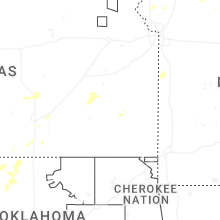
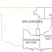
Oklahoma
| Local Time | Report Details |
|---|---|
| 8:00 PM CDT | Report relayed by emergency managemen in garfield county OK, 76.3 miles NNW of Oklahoma City, OK |
| 8:05 PM CDT | Powerlines blown down near the intersection of 16th street and keowee street. time estimated from rada in garfield county OK, 76.6 miles NNW of Oklahoma City, OK |
| 8:11 PM CDT | Storm damage reported in grant county OK, 74.7 miles SSW of Wichita, KS |
| 8:19 PM CDT | Quarter sized hail reported near Kremlin, OK, 76.3 miles NNW of Oklahoma City, OK, report relayed by emergency management. |
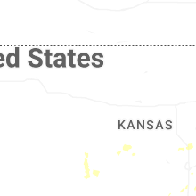
Kansas
| Local Time | Report Details |
|---|---|
| 8:40 PM CDT | Half Dollar sized hail reported near Newton, KS, 25 miles N of Wichita, KS, courtesy of kwch. |
| 8:48 PM CDT | Quarter sized hail reported near Newton, KS, 25 miles N of Wichita, KS |
Connect with Interactive Hail Maps