

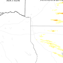
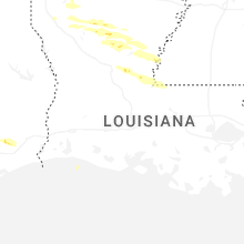
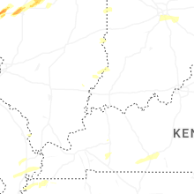
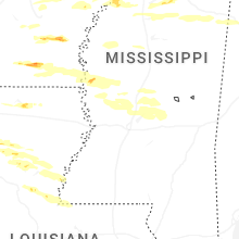
Hail Map for Tuesday, May 20, 2025

Number of Impacted Households on 5/20/2025
0
Impacted by 1" or Larger Hail
0
Impacted by 1.75" or Larger Hail
0
Impacted by 2.5" or Larger Hail
Square Miles of Populated Area Impacted on 5/20/2025
0
Impacted by 1" or Larger Hail
0
Impacted by 1.75" or Larger Hail
0
Impacted by 2.5" or Larger Hail

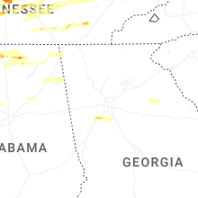

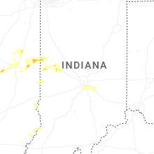
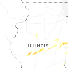
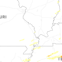

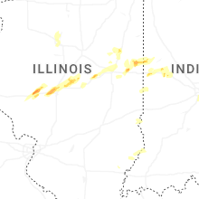
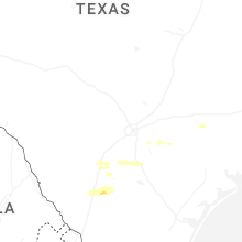
Cities Most Affected by Hail Storms of 5/20/2025
| Hail Size | Demographics of Zip Codes Affected | ||||||
|---|---|---|---|---|---|---|---|
| City | Count | Average | Largest | Pop Density | House Value | Income | Age |
| Franklin, TN | 10 | 2.18 | 3.00 | 279 | $188k | $59.5k | 39.2 |
| Huntsville, AL | 5 | 2.00 | 2.75 | 1573 | $121k | $42.3k | 41.6 |
| Town Creek, AL | 3 | 2.83 | 3.00 | 50 | $70k | $31.3k | 40.7 |
| Centerville, TN | 4 | 1.88 | 2.00 | 30 | $83k | $29.2k | 43.9 |
| Thompsons Station, TN | 2 | 2.13 | 2.50 | 218 | $161k | $60.9k | 34.9 |
| Athens, AL | 2 | 1.88 | 2.00 | 240 | $96k | $40.2k | 39.0 |
| Ashland, IL | 1 | 2.50 | 2.50 | 13 | $71k | $42.9k | 43.1 |
| Mahomet, IL | 1 | 2.00 | 2.00 | 252 | $115k | $55.0k | 37.5 |
| Columbia, TN | 1 | 2.00 | 2.00 | 185 | $97k | $41.0k | 38.6 |
| Stuttgart, AR | 1 | 2.00 | 2.00 | 32 | $60k | $32.2k | 39.2 |
| Pleasant Plains, IL | 1 | 2.00 | 2.00 | 25 | $97k | $50.8k | 43.6 |
| Buena Vista, TN | 1 | 2.00 | 2.00 | 16 | $52k | $30.6k | 41.5 |
| Jacksonville, IL | 1 | 2.00 | 2.00 | 119 | $81k | $35.5k | 40.2 |
| Alvin, IL | 1 | 1.75 | 1.75 | 19 | $56k | $43.0k | 39.8 |
| Cherokee, AL | 1 | 1.75 | 1.75 | 21 | $57k | $29.7k | 45.2 |
| Rogersville, AL | 1 | 1.75 | 1.75 | 98 | $87k | $35.2k | 43.4 |
| Owens Cross Roads, AL | 1 | 1.75 | 1.75 | 384 | $183k | $62.1k | 39.2 |
| Tullos, LA | 1 | 1.75 | 1.75 | 4 | $34k | $32.0k | 42.1 |
| Primm Springs, TN | 1 | 1.75 | 1.75 | 29 | $87k | $50.3k | 43.5 |
| Oxford, MS | 1 | 1.75 | 1.75 | 105 | $109k | $27.8k | 29.2 |
| Latham, IL | 1 | 1.75 | 1.75 | 10 | $64k | $48.1k | 41.6 |
| Murfreesboro, TN | 1 | 1.75 | 1.75 | 852 | $119k | $51.8k | 31.6 |
| Tanner, AL | 1 | 1.75 | 1.75 | 32 | $88k | $32.5k | 41.4 |
| Wynne, AR | 1 | 1.75 | 1.75 | 52 | $69k | $30.9k | 38.8 |
Hail and Wind Damage Spotted on 5/20/2025
Filter by Report Type:Hail ReportsWind Reports
States Impacted
Mississippi, Tennessee, Illinois, Kentucky, Arkansas, Alabama, South Carolina, Missouri, Virginia, Texas, Louisiana, Georgia, North CarolinaMississippi
| Local Time | Report Details |
|---|---|
| 7:42 AM CDT | Trees down on strickland road. time estimated from rada in marshall county MS, 29.2 miles SE of Memphis, TN |
| 7:43 AM CDT | Tree on house on highway 309. additional trees down on hill view d in marshall county MS, 29.5 miles SE of Memphis, TN |
| 8:09 AM CDT | Tree down on vehicle off of slayden roa in marshall county MS, 39.1 miles ESE of Memphis, TN |
| 2:22 PM CDT | Tree through a house on britton drive. time is radar estimate in lafayette county MS, 59 miles SSE of Memphis, TN |
| 2:29 PM CDT | Quarter sized hail reported near Abbeville, MS, 60.7 miles SSE of Memphis, TN, quarter sized hail 5mi ne of oxford on hwy 30. |
| 2:35 PM CDT | Golf Ball sized hail reported near Oxford, MS, 60.7 miles SSE of Memphis, TN, golf ball sized hail reported north of oxford. |
| 3:52 PM CDT | Trees down along cr 1101 near boonevill in prentiss county MS, 49.3 miles W of Florence, AL |
| 4:14 PM CDT | Tree on shed on cr 148 between hwy 125 and holcu in tishomingo county MS, 32.6 miles W of Florence, AL |
| 4:18 PM CDT | Quarter sized hail reported near Coahoma, MS, 60.2 miles SSW of Memphis, TN, report from mping: quarter (1.00 in.). |
| 5:32 PM CDT | Trees down on cr 10 in lafayette county MS, 55.7 miles SSE of Memphis, TN |
| 6:04 PM CDT | Tree down along hwy 436 at beargarden r in washington county MS, 59 miles ENE of Bastrop, LA |
| 6:16 PM CDT | Multiple utility poles were snapped along sunflower river rd in the murphy community. report and pictures via social medi in washington county MS, 64.2 miles NNW of Jackson, MS |
| 6:22 PM CDT | Reports of tree damage in the ingomar are in union county MS, 66.4 miles N of Starkville, MS |
| 7:36 PM CDT | Large tree down along the corner of dorsey-evergreen rd and mcmaster r in itawamba county MS, 52.2 miles NNE of Starkville, MS |
| 7:43 PM CDT | Quarter sized hail reported near Shannon, MS, 43.5 miles N of Starkville, MS |
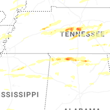
Tennessee
| Local Time | Report Details |
|---|---|
| 9:58 AM CDT | Reported tree down along highway 142 and kimberly ln. time estimated on rada in hardin county TN, 40.7 miles WNW of Florence, AL |
| 10:00 AM CDT | Reported tree down in michie... tn. time estimated on rada in hardin county TN, 40.1 miles WNW of Florence, AL |
| 10:30 AM CDT | Emergency manager reports several large trees down... as well as damage to a few sheds. from em and pictures... everything blown eas in wayne county TN, 24.8 miles NNW of Florence, AL |
| 1:17 PM CDT | Delayed report. emergency manager reports of damage in chapel hill. possible tornado. time estimated from rada in marshall county TN, 44.7 miles S of Nashville, TN |
| 3:10 PM EDT | Power lines down at lookout av in roane county TN, 24.3 miles WNW of Knoxville, TN |
| 2:28 PM CDT | Trees down on sand ridge bargerton r in henderson county TN, 31.4 miles S of Mc Kenzie, TN |
| 3:30 PM EDT | Storm damage reported in knox county TN, 7.8 miles NW of Knoxville, TN |
| 3:17 PM CDT | Roof damage noted to the tbi/tn hwy patrol building and additional damage noted at the kirklands warehouse just west of mkl off smith lane. time is radar estimated. pos in madison county TN, 43.1 miles SSW of Mc Kenzie, TN |
| 3:25 PM CDT | Multiple trees down across northern perry county... including along red bank road. time estimated via rada in perry county TN, 44.8 miles ESE of Mc Kenzie, TN |
| 4:27 PM EDT | Numerous trees down hwy160 near pinebroo in hamblen county TN, 38.7 miles ENE of Knoxville, TN |
| 3:30 PM CDT | Awos station kucy union cit in obion county TN, 30.8 miles NW of Mc Kenzie, TN |
| 3:45 PM CDT | Tree down on a house on lee street in martin. time is radar estimate in weakley county TN, 23.8 miles NW of Mc Kenzie, TN |
| 3:47 PM CDT | Trees down on hwy 19 east at old ross road. time is radar estimate in lauderdale county TN, 50 miles NE of Memphis, TN |
| 3:50 PM CDT | Trees reported down at hickman county high school. time estimated from rada in hickman county TN, 44.1 miles SW of Nashville, TN |
| 3:50 PM CDT | Golf Ball sized hail reported near Centerville, TN, 44.1 miles SW of Nashville, TN, golf ball size hail reported at hickman county high school. time estimated from radar. |
| 3:54 PM CDT | Significant tree damage impacting multiple houses on the west side of martin. power poles also down. time is radar estimate in weakley county TN, 24.2 miles NW of Mc Kenzie, TN |
| 3:54 PM CDT | Hen Egg sized hail reported near Centerville, TN, 44.1 miles SW of Nashville, TN, estimated 2 inch hail near centerville middle school. time estimated from radar. |
| 3:56 PM CDT | Golf Ball sized hail reported near Centerville, TN, 44.1 miles SW of Nashville, TN, golf ball size hail at hickman county high school. |
| 3:56 PM CDT | Hen Egg sized hail reported near Centerville, TN, 38.9 miles WSW of Nashville, TN, two inch hail reported near tn 100 and tn 230 north of centerville. time estimated from radar. |
| 4:00 PM CDT | Quarter sized hail reported near Centerville, TN, 46 miles WSW of Nashville, TN, public report of penny to quarter sized hail near elkins rd in centerville. |
| 4:00 PM CDT | Large tree downed at the intersection of old memphis road and fayne r in tipton county TN, 29.1 miles NE of Memphis, TN |
| 4:03 PM CDT | Trees down on hwy 188 on the gibson/crockett county line in the eaton communit in gibson county TN, 36 miles WSW of Mc Kenzie, TN |
| 5:05 PM EDT | Trees on powerlines. time estimated by rada in greene county TN, 52 miles ENE of Knoxville, TN |
| 5:08 PM EDT | Trees down on blue springs pkwy. time estimated by rada in greene county TN, 48.7 miles SW of Bristol, TN |
| 4:09 PM CDT | Trees down highway 69 n/new boston rd... cottage grov in henry county TN, 17.2 miles N of Mc Kenzie, TN |
| 5:10 PM EDT | Numerous trees and powerlines down across the city. time estimated by rada in greene county TN, 44.3 miles SW of Bristol, TN |
| 5:13 PM EDT | Tractor trailer knocked over on snapps ferry rd. time estimated by rada in greene county TN, 42.1 miles SW of Bristol, TN |
| 4:14 PM CDT | Golf Ball sized hail reported near Primm Springs, TN, 27.8 miles SW of Nashville, TN, estimated golf ball size hail in primm springs. time estimated from radar. |
| 4:17 PM CDT | Trees and powerlines down on ferguson rd in puryea in henry county TN, 23.4 miles NNE of Mc Kenzie, TN |
| 4:18 PM CDT | Hen Egg sized hail reported near Buena Vista, TN, 18.4 miles SE of Mc Kenzie, TN, photo of significant hail (looks like 2 inches) in the buena vista community of carroll county. time is radar estimated. |
| 4:18 PM CDT | Tree down on hwy 19 outside of brownsville. time matched with strong outbound velocity surge on rada in haywood county TN, 52.9 miles NE of Memphis, TN |
| 4:20 PM CDT | Hen Egg sized hail reported near Franklin, TN, 22.2 miles SW of Nashville, TN, estimated 2 inch hail in leipers fork. time estimated from radar. |
| 4:21 PM CDT | Golf Ball sized hail reported near Franklin, TN, 28.8 miles SW of Nashville, TN, golf ball size hail off natchez trace and bending chestnut. time estimated from radar. |
| 4:30 PM CDT | Several trees down and hail. hail size unknow in marion county TN, 20.2 miles NW of Chattanooga, TN |
| 4:34 PM CDT | Quarter sized hail reported near Thompsons Station, TN, 26.4 miles SSW of Nashville, TN, estimated 1 inch hail at thompson station road and columbia pike. time estimated from radar. |
| 4:34 PM CDT | Ping Pong Ball sized hail reported near Thompsons Station, TN, 26.4 miles S of Nashville, TN, estimated from picture received at pratt road in thompsons station. |
| 4:34 PM CDT | Tennis Ball sized hail reported near Thompsons Station, TN, 24.8 miles SSW of Nashville, TN, estimated tennis ball size hail in thompsons station near i-840. time estimated from radar. |
| 4:35 PM CDT | Ping Pong Ball sized hail reported near Camden, TN, 24.2 miles ESE of Mc Kenzie, TN, video of pingpong ball sized hail and strong wind gusts. |
| 4:36 PM CDT | Baseball sized hail reported near Franklin, TN, 21.4 miles SSW of Nashville, TN, estimated baseball size hail near franklin. time estimated from radar. |
| 4:36 PM CDT | Quarter sized hail reported near Thompsons Station, TN, 26.4 miles SSW of Nashville, TN, report from mping: quarter (1.00 in.). |
| 4:37 PM CDT | Golf Ball sized hail reported near Thompsons Station, TN, 24.6 miles SSW of Nashville, TN, report from mping: golf ball (1.75 in.). |
| 4:38 PM CDT | Golf Ball sized hail reported near Franklin, TN, 19.3 miles SSW of Nashville, TN, up to golf ball size hail reported at the public safety center in franklin. time estimated from radar. |
| 4:38 PM CDT | Tea Cup sized hail reported near Franklin, TN, 22.8 miles SSW of Nashville, TN, photo received of very large hail on keystone drive south of franklin. time estimated from radar. |
| 4:40 PM CDT | Trees and powerlines down at highway 79 and onion hill west of dove in stewart county TN, 40.2 miles NE of Mc Kenzie, TN |
| 4:40 PM CDT | Quarter sized hail reported near Franklin, TN, 21.6 miles S of Nashville, TN, quarter size hail on goose creek and lewisburg pike near franklin. time estimated from radar. |
| 4:40 PM CDT | Golf Ball sized hail reported near Franklin, TN, 18.9 miles SSW of Nashville, TN, estimated golf ball size hail near mack hatcher and lewisburg pike near franklin. time estimated from radar. |
| 4:40 PM CDT | Golf Ball sized hail reported near Franklin, TN, 19.6 miles SSW of Nashville, TN, estimated golf ball size hail in sullivan farms. time estimated from radar. |
| 4:40 PM CDT | Hen Egg sized hail reported near Franklin, TN, 19.6 miles SSW of Nashville, TN, two inch hail measured in sullivan farms. time estimated from radar. |
| 4:40 PM CDT | Em reports downed trees and structure damage west of dover. time estimated from rada in stewart county TN, 43 miles NE of Mc Kenzie, TN |
| 4:41 PM CDT | Quarter sized hail reported near Mount Pleasant, TN, 50.8 miles SSW of Nashville, TN, quarter size hail at jackson street in mount pleasant. time estimated from radar. |
| 4:41 PM CDT | Half Dollar sized hail reported near Franklin, TN, 19.7 miles SSW of Nashville, TN, quarter to half dollar size hail reported along heathersett drive in dallas downs. |
| 4:42 PM CDT | Hen Egg sized hail reported near Franklin, TN, 18.1 miles S of Nashville, TN, measured two inch hail in maplewood subdivision in franklin. time estimated from radar. |
| 4:42 PM CDT | Tea Cup sized hail reported near Franklin, TN, 22.6 miles S of Nashville, TN, measured 3 inch hail in franklin. time estimated from radar. |
| 4:42 PM CDT | Quarter sized hail reported near Franklin, TN, 18 miles S of Nashville, TN, estimated quarter size hail on oak meadow drive in franklin. time estimated from radar. |
| 4:46 PM CDT | Trees down in the 2000 block of highway 120 in big rock. time estimate in stewart county TN, 49.8 miles NE of Mc Kenzie, TN |
| 4:47 PM CDT | Asos station kmkl jackso in madison county TN, 43.1 miles SSW of Mc Kenzie, TN |
| 4:55 PM CDT | Quarter sized hail reported near Columbia, TN, 41.4 miles SSW of Nashville, TN, quarter size hail reported at maury county eoc. time estimated from radar. |
| 4:55 PM CDT | Ping Pong Ball sized hail reported near Columbia, TN, 42.7 miles SSW of Nashville, TN, ping pong size hail reported at s james campbell blvd and brooksmeade in columbia. |
| 4:55 PM CDT | Tree down on powerline in the springville community. time is radar estimate in henry county TN, 22.2 miles ENE of Mc Kenzie, TN |
| 4:56 PM CDT | Half Dollar sized hail reported near Columbia, TN, 41.8 miles SSW of Nashville, TN, hail a little bigger than quarters reported in columbia. time estimated from radar. |
| 4:59 PM CDT | Ping Pong Ball sized hail reported near Columbia, TN, 41 miles SSW of Nashville, TN, report from mping: ping pong ball (1.50 in.). |
| 5:02 PM CDT | Hen Egg sized hail reported near Columbia, TN, 39.1 miles SSW of Nashville, TN, measured 2 inch hail on tom osborne road near boyd butler road. time estimated from radar. |
| 5:02 PM CDT | Half Dollar sized hail reported near Columbia, TN, 41.2 miles SSW of Nashville, TN, at the maury county office of emergency management. |
| 5:15 PM CDT | 643 customers without power in adam in robertson county TN, 32.5 miles NNW of Nashville, TN |
| 5:17 PM CDT | Several large trees down across i-24 at mm72 with trees also down across blackman road. two lanes of i-24 blocked. time estimate in rutherford county TN, 26.3 miles SE of Nashville, TN |
| 5:17 PM CDT | Structural damage reported in the blackman area. time estimated by rada in rutherford county TN, 25.8 miles SE of Nashville, TN |
| 5:17 PM CDT | Multiple structures with light damage and dozens of large trees and powerlines down. time estimate in rutherford county TN, 23.6 miles SE of Nashville, TN |
| 5:19 PM CDT | Downed powerline at florence road & valor drive. time estimate in rutherford county TN, 24.8 miles SE of Nashville, TN |
| 5:20 PM CDT | Trees dow in sequatchie county TN, 21.5 miles NNW of Chattanooga, TN |
| 5:45 PM CDT | Tree down on home on keys branch road near bon aqu in hickman county TN, 41.6 miles WSW of Nashville, TN |
| 5:49 PM CDT | Golf Ball sized hail reported near Murfreesboro, TN, 32.6 miles SSE of Nashville, TN, estimated golf ball size hail near christiana. time estimated. |
| 6:50 PM EDT | Several trees dow in hamilton county TN, 22.6 miles NNE of Chattanooga, TN |
| 5:50 PM CDT | Tree down on home in the joelton area. time estimated by rada in davidson county TN, 11.1 miles NNW of Nashville, TN |
| 5:50 PM CDT | Trees and powerlines down in the knob creek and white road areas east of wartrace. time estimated from rada in bedford county TN, 52.4 miles SSE of Nashville, TN |
| 5:51 PM CDT | Tree fell on a vehicle along sr 48 in hickman county. minor injuries to the driver reported. time estimated from rada in hickman county TN, 44.2 miles WSW of Nashville, TN |
| 5:55 PM CDT | Large tree down at highway 25 east at cedar grove in cross plains blocking the road. time estimated from rada in robertson county TN, 26.2 miles NNE of Nashville, TN |
| 5:56 PM CDT | Tree down on ellen drive in goodlettsville. time estimated from rada in sumner county TN, 12.2 miles NNE of Nashville, TN |
| 6:07 PM CDT | Half Dollar sized hail reported near Dowelltown, TN, 50 miles ESE of Nashville, TN, report from mping: half dollar (1.25 in.). |
| 6:15 PM CDT | Tree blocked johnson hollow road south of interstate 840 near mobley’s cut road between boston and burwood. time estimated from rada in williamson county TN, 27.3 miles SSW of Nashville, TN |
| 6:19 PM CDT | Quarter sized hail reported near Auburntown, TN, 40.8 miles ESE of Nashville, TN, estimated quarter size hail in auburntown. time estimated from radar. |
| 7:44 PM EDT | Several trees dow in mcminn county TN, 48.3 miles NE of Chattanooga, TN |
| 6:46 PM CDT | Ping Pong Ball sized hail reported near Spencer, TN, 47.8 miles N of Chattanooga, TN, estimated ping pong size hail in van buren county. time estimated from radar. |
| 7:01 PM CDT | Quarter sized hail reported near Quebeck, TN, 54.5 miles NNW of Chattanooga, TN, quarter-size hail in quebeck. |
| 7:39 PM CDT | Trees down and nickel size hai in sequatchie county TN, 25.3 miles N of Chattanooga, TN |
| 7:40 PM CDT | Multiple trees down across western and central putnam county. time estimate in cumberland county TN, 62.7 miles W of Knoxville, TN |
| 7:40 PM CDT | Correct previous report from 1 nnw crossville. multiple trees down across western and central putnam county. time estimate in putnam county TN, 70.4 miles E of Nashville, TN |
| 8:00 PM CDT | Quarter sized hail reported near Crossville, TN, 54.6 miles NNE of Chattanooga, TN, golf ball size hail on burgess road. time estimated. |
| 8:05 PM CDT | Structure damage reported on rhea road. time estimate in cumberland county TN, 55.9 miles NNE of Chattanooga, TN |
| 8:31 PM CDT | Damage reported at vandever road and highway 127. time estimated from rada in cumberland county TN, 55.1 miles NNE of Chattanooga, TN |
| 9:40 PM EDT | Trees reported down in scott count in scott county TN, 50.4 miles NW of Knoxville, TN |
| 9:45 PM EDT | Several trees dow in scott county TN, 49.7 miles NW of Knoxville, TN |
| 9:50 PM EDT | Several trees dow in mcminn county TN, 46.2 miles SW of Knoxville, TN |
| 9:51 PM EDT | Trees dow in roane county TN, 24.1 miles W of Knoxville, TN |
| 10:10 PM EDT | Re-sending report. measured on an at home anemomete in knox county TN, 13.5 miles WSW of Knoxville, TN |
| 10:15 PM EDT | Trees down county-wid in knox county TN, 3.4 miles WNW of Knoxville, TN |
| 10:27 PM EDT | Trees down at maryville housing authorit in blount county TN, 14.2 miles SSW of Knoxville, TN |
| 10:40 PM EDT | A few trees dow in claiborne county TN, 42.5 miles NNE of Knoxville, TN |
| 10:42 PM EDT | Several trees dow in sevier county TN, 16.3 miles ENE of Knoxville, TN |
| 10:50 PM EDT | Large tree down blocking at least a lane on highway 441 going north near zion hill are in sevier county TN, 15.9 miles ESE of Knoxville, TN |
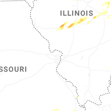
Illinois
| Local Time | Report Details |
|---|---|
| 1:24 PM CDT | Half Dollar sized hail reported near Jacksonville, IL, 74.6 miles SSW of Peoria, IL, quarter to half dollar hail... relayed by media. |
| 1:24 PM CDT | Hen Egg sized hail reported near Jacksonville, IL, 74.6 miles SSW of Peoria, IL |
| 1:24 PM CDT | Measured gust... no damage note in morgan county IL, 74.6 miles SSW of Peoria, IL |
| 1:47 PM CDT | Tennis Ball sized hail reported near Ashland, IL, 64.4 miles SSW of Peoria, IL, time estimated from radar. |
| 1:56 PM CDT | Hen Egg sized hail reported near Pleasant Plains, IL, 63.5 miles SSW of Peoria, IL |
| 2:00 PM CDT | Two two-three inch diameter branches snappe in mercer county IL, 63.6 miles NW of Peoria, IL |
| 2:02 PM CDT | Tree down on i-74 blocking eastbound right lan in knox county IL, 36.9 miles WNW of Peoria, IL |
| 2:07 PM CDT | 7in diameter tree uprooted this afternoon. time based on rada in rock island county IL, 70.1 miles NW of Peoria, IL |
| 2:08 PM CDT | A few very large branches of trees downed. time estimated using rada in henry county IL, 40.6 miles NW of Peoria, IL |
| 2:19 PM CDT | Corrects previous tstm wnd dmg report from 1 wnw east moline. 2 inch diameter branch down. time estimated from rada in rock island county IL, 71 miles ESE of Cedar Rapids, IA |
| 2:19 PM CDT | 2 inch diameter branch down. time estimated from rada in rock island county IL, 71.1 miles ESE of Cedar Rapids, IA |
| 2:25 PM CDT | 2-3" diameter tree limbs blown dow in peoria county IL, 1.9 miles N of Peoria, IL |
| 2:28 PM CDT | Quarter sized hail reported near Chatham, IL, 68.4 miles S of Peoria, IL, time based on radar. |
| 2:30 PM CDT | Quarter sized hail reported near Loami, IL, 67.5 miles S of Peoria, IL, report from mping: quarter (1.00 in.). |
| 2:32 PM CDT | 3-4" diameter tree limbs blown dow in peoria county IL, 9.8 miles NNW of Peoria, IL |
| 2:32 PM CDT | Ping Pong Ball sized hail reported near New Berlin, IL, 65 miles S of Peoria, IL |
| 2:33 PM CDT | Half Dollar sized hail reported near New Berlin, IL, 65 miles S of Peoria, IL, quarter to half dollar size hail at centennial park. |
| 2:34 PM CDT | Ping Pong Ball sized hail reported near Springfield, IL, 61.2 miles S of Peoria, IL, delayed report. ping pong sized hail near interchange of highway 97 and highway 4. |
| 2:40 PM CDT | Ping Pong Ball sized hail reported near Springfield, IL, 63.4 miles S of Peoria, IL, west side of springfield near the intersection of archer elevator and greenbriar rds. |
| 2:41 PM CDT | Half Dollar sized hail reported near Springfield, IL, 61.8 miles S of Peoria, IL |
| 2:45 PM CDT | Quarter sized hail reported near Pekin, IL, 5 miles S of Peoria, IL, relayed by media. time estimated from radar. |
| 3:29 PM CDT | Half Dollar sized hail reported near Mount Pulaski, IL, 54.4 miles SSE of Peoria, IL, photo of hail slightly larger than quarters. |
| 3:35 PM CDT | Golf Ball sized hail reported near Latham, IL, 52.8 miles NW of Mattoon, IL |
| 3:38 PM CDT | Quarter sized hail reported near Paxton, IL, 69.1 miles NNE of Mattoon, IL, quarter size hail in paxton. relayed via broadcast media. time estimated by radar. |
| 3:45 PM CDT | Quarter sized hail reported near Forsyth, IL, 43.9 miles NW of Mattoon, IL |
| 4:00 PM CDT | Quarter sized hail reported near Paxton, IL, 69.1 miles NNE of Mattoon, IL, half dollar size hail in paxton. relayed by broadcast media. time estimated by radar. |
| 4:00 PM CDT | Half Dollar sized hail reported near Paxton, IL, 69.1 miles NNE of Mattoon, IL, corrects previous hail report from paxton. half dollar size hail in paxton. relayed by broadcast media. time estimated by radar. |
| 4:03 PM CDT | Quarter sized hail reported near Cisco, IL, 42.3 miles NNW of Mattoon, IL |
| 4:10 PM CDT | Quarter sized hail reported near Fisher, IL, 57.9 miles N of Mattoon, IL |
| 4:17 PM CDT | Ping Pong Ball sized hail reported near Loda, IL, 72.1 miles NNE of Mattoon, IL, 1.5 inch hail and 60 mph winds estimated at location. time estimated by radar. |
| 4:34 PM CDT | Tree down on a vehicle in pittsfiel in pike county IL, 74.4 miles NNW of Saint Louis, MO |
| 4:42 PM CDT | Quarter sized hail reported near Mahomet, IL, 48.9 miles N of Mattoon, IL |
| 4:45 PM CDT | Ping Pong Ball sized hail reported near Mahomet, IL, 48.9 miles N of Mattoon, IL |
| 4:45 PM CDT | Hen Egg sized hail reported near Mahomet, IL, 48.9 miles N of Mattoon, IL, relayed by media. |
| 5:10 PM CDT | Tree and power line damage along potomac-collison rd. north of county road 2800 in vermilion county IL, 62.8 miles NNE of Mattoon, IL |
| 5:30 PM CDT | Golf Ball sized hail reported near Alvin, IL, 68.7 miles NNE of Mattoon, IL, a mile north of intersection of us-136 and il-119. |
| 5:35 PM CDT | Quarter sized hail reported near Bismarck, IL, 67.9 miles NE of Mattoon, IL |
| 6:08 PM CDT | Time estimated from rada in vermilion county IL, 64 miles NNE of Mattoon, IL |
| 6:50 PM CDT | 1 to 2 foot diameter pine trees snappe in vermilion county IL, 54 miles NE of Mattoon, IL |
Kentucky
| Local Time | Report Details |
|---|---|
| 2:34 PM EDT | A tree was blown down into a light pole on plaza drive near prince royal drive in berea. time estimated from rada in madison county KY, 20.5 miles WSW of Irvine, KY |
| 2:35 PM EDT | County dispatch reported a tree blown down and partially blocking n ky-66 near the intersection with ky-149. event time estimated from rada in clay county KY, 39.9 miles SSE of Irvine, KY |
| 2:48 PM EDT | County dispatch relayed a report and picture media showed a picture of a tree blown down along the 1900 block of somerset road in the vicinity of allen house lane. pict in laurel county KY, 39 miles SSW of Irvine, KY |
| 3:00 PM EDT | Tree blown down at the powell-estill county line... on the powell side. event time estimated from rada in powell county KY, 9.7 miles N of Irvine, KY |
| 3:02 PM EDT | County dispatch reported tree blown down near the intersection of maplesville school and old salem road. event time estimated from rada in laurel county KY, 37.4 miles S of Irvine, KY |
| 3:06 PM EDT | Tree reportedly blown down near mm 7 along the hal rogers parkway. event time estimated from rada in laurel county KY, 40.7 miles S of Irvine, KY |
| 3:23 PM EDT | Two trees blown down about a mile from the slade rest area in the vicinity of thatchers bbq. event time estimated from rada in powell county KY, 16.3 miles ENE of Irvine, KY |
| 3:26 PM EDT | County dispatch reported a tree blown down and partially blocking ky-11 near the knox/clay county line. even time estimated from rada in clay county KY, 47 miles S of Irvine, KY |
| 3:29 PM EDT | Tree was reported down near rogers elementary school. time estimated by rada in wolfe county KY, 18.5 miles E of Irvine, KY |
| 3:37 PM EDT | County dispatch reported multiple trees blown down around the county including up ky-516 and ky-190. event time estimated from rada in bell county KY, 55.9 miles NNE of Knoxville, TN |
| 3:49 PM EDT | Tree reportedly blown along bowlings creek road about 1.5 miles from the mouth of the holler. event time estimated from rada in breathitt county KY, 37.6 miles SE of Irvine, KY |
| 3:56 PM EDT | Tree was reportedly blown down onto power lines along ky-541 near the mount carmel schoo in breathitt county KY, 29.1 miles ESE of Irvine, KY |
| 3:59 PM EDT | Tree reportedly blown down on grapevine road (ky-28) near the intersection with ky-15. event time estimated from rada in perry county KY, 44.2 miles ESE of Irvine, KY |
| 3:59 PM EDT | A tree was blown down onto us 421 near the leslie county rv park and mm 2 in leslie county KY, 48.9 miles SE of Irvine, KY |
| 4:02 PM EDT | Large tree limbs reportedly broken off across from the ekcc entrance just south of west liberty. event time estimated from rada in morgan county KY, 41.2 miles ENE of Irvine, KY |
| 4:09 PM EDT | A tree was blown down onto ky 699 (cutshin road) near mile marker 5 or near the intersection with cr 1537 (little engle road in leslie county KY, 55.8 miles SE of Irvine, KY |
| 3:56 PM CDT | State police reported two trees blocking bell city road... and an outbuilding blown ove in graves county KY, 35.3 miles N of Mc Kenzie, TN |
| 4:17 PM CDT | Power outages reporte in calloway county KY, 34.7 miles NNE of Mc Kenzie, TN |
| 4:32 PM CDT | Power outages and trees dow in calloway county KY, 34.7 miles NNE of Mc Kenzie, TN |
| 4:39 PM CDT | Power outages reporte in christian county KY, 63.6 miles NW of Nashville, TN |
| 4:56 PM CDT | Tree down over roa in christian county KY, 66.8 miles NW of Nashville, TN |
| 4:59 PM CDT | Trees down north of adairvill in logan county KY, 39.7 miles N of Nashville, TN |
| 5:00 PM CDT | Delayed report. a roof blown off a barn... power poles down... and a few trees down in oakville communit in logan county KY, 40.5 miles N of Nashville, TN |
| 5:02 PM CDT | Several trees down in graha in muhlenberg county KY, 53.2 miles SSE of Evansville, IN |
| 5:33 PM CDT | Tree down blocking matlock rd near rich pond r in warren county KY, 51.6 miles NNE of Nashville, TN |
| 5:43 PM CDT | Tree and a powerline down in the road. provo road. time estimated from rada in butler county KY, 66.8 miles SE of Evansville, IN |
| 5:45 PM CDT | Tree all the way across the road on mckendree chapel rd. time estimated from rada in butler county KY, 69.9 miles SE of Evansville, IN |
| 5:49 PM CDT | Tree down in caneyville. time estimated from rada in grayson county KY, 57.7 miles SW of Louisville, KY |
| 5:52 PM CDT | Tree in road at 4011 caneyville road. time estimated from rada in butler county KY, 68.5 miles SE of Evansville, IN |
| 5:54 PM CDT | Tree down in the roadway at 415 caney fork road. time estimated from rada in butler county KY, 60.9 miles N of Nashville, TN |
| 5:55 PM CDT | Metal building in road way. time estimated from rada in barren county KY, 69.4 miles SSW of Louisville, KY |
| 5:56 PM CDT | Tree down across lane on 23 mile marker southboun in butler county KY, 68.7 miles N of Nashville, TN |
| 6:06 PM CDT | Tree down across the road in the 1600 block of threlkel rd. time estimated from rada in butler county KY, 67.9 miles SW of Louisville, KY |
| 6:14 PM CDT | Tree blocking half the roa in barren county KY, 66.6 miles S of Louisville, KY |
| 6:15 PM CDT | Tree down blocking the road at 641 crawford road. time estimated from rada in barren county KY, 63 miles S of Louisville, KY |
| 6:17 PM CDT | Tree down. time estimated from rada in grayson county KY, 51.4 miles SW of Louisville, KY |
| 6:38 PM CDT | Tree down blocking whole road in the 9000 block of austin tracy rd. time estimated from rada in barren county KY, 62.1 miles NE of Nashville, TN |
| 6:40 PM CDT | Tree down blocking the roadway near roseville road and cooktown road. time estimated from rada in barren county KY, 66.1 miles NE of Nashville, TN |
| 8:41 PM EDT | Tree down blocking 1 lane of preachersville road. time estimated from rada in lincoln county KY, 34.9 miles WSW of Irvine, KY |
| 8:45 PM EDT | Trees down across crab orchard road near gilberts creek baptist church. time estimated from rada in garrard county KY, 32.8 miles WSW of Irvine, KY |
| 8:46 PM EDT | Trees down across highway 39. time estimated from rada in lincoln county KY, 32.6 miles WSW of Irvine, KY |
| 9:09 PM EDT | A tree was blown down at 2000 scaffold cane road mount vernon in northern rockcastle count in rockcastle county KY, 23.4 miles SW of Irvine, KY |
| 9:10 PM EDT | A tree was blow down onto a home at 6342 willailla road... brodhead... ky. the time of the event is radar estimate in rockcastle county KY, 38.8 miles SW of Irvine, KY |
| 9:12 PM EDT | Tree down near the entrance to battlefield golf course. time estimated from rada in madison county KY, 15.8 miles W of Irvine, KY |
| 9:23 PM EDT | A tree was down near mm 10 on us 25 south daniel boone trail. the event time is radar estimate in rockcastle county KY, 30 miles SW of Irvine, KY |
| 9:34 PM EDT | Tree down blocking part of wisemantown rd between richmond rd and s winn rd. location and time estimate in estill county KY, 2 miles SW of Irvine, KY |
| 9:35 PM EDT | Large tree down. report via social media. time estimated via rada in estill county KY, 2.1 miles WSW of Irvine, KY |
| 9:45 PM EDT | Laurel county 911 reports a tree down on a house in the 100 block of lawson lan in laurel county KY, 50.4 miles SSW of Irvine, KY |
| 9:47 PM EDT | Trees were reported to have been blown down on us 25w near the intersection with lick fork road. the event time is radar estimate in whitley county KY, 59.6 miles SSW of Irvine, KY |
| 9:51 PM EDT | Report via social media of window blown out at a residence by thunderstorm winds along american greeting card rd near corbi in laurel county KY, 50.1 miles S of Irvine, KY |
| 9:51 PM EDT | Trees and powerlines were reported to have been blown down in the bearkat drive vicinity in williamsburg. the event time is radar estimate in whitley county KY, 54 miles NNW of Knoxville, TN |
| 9:57 PM EDT | Trees were reported to have been blown down in the mountain ash community. the event time is radar estimate in whitley county KY, 49.6 miles NNW of Knoxville, TN |
| 10:00 PM EDT | One tree down onto ky 11 near 4000 ky 11 campton. the event time is radar estimate in wolfe county KY, 17.5 miles E of Irvine, KY |
| 10:01 PM EDT | Tees down on keswick road in southern whitley county. the event time is radar estimate in whitley county KY, 45.8 miles NNW of Knoxville, TN |
| 10:03 PM EDT | Trees were reported to have been blown down on lick fork road in eastern whitely county. the event time is radar estimate in whitley county KY, 51.8 miles N of Knoxville, TN |
| 10:18 PM EDT | Report via social media of power line down on ky highway 66 from white mountain rd to near long branch rd. time and location estimated via rada in bell county KY, 61.3 miles NNE of Knoxville, TN |
| 10:18 PM EDT | 6 trees and a power line down along ky highway 66 in bell county. time estimated via rada in bell county KY, 57.5 miles NNE of Knoxville, TN |
| 10:19 PM EDT | A large tree and powerlines were reported to have been blown down between mm 12 and the red river elementary school. the event time is radar estimate in wolfe county KY, 32.6 miles E of Irvine, KY |
| 10:35 PM EDT | A tree was blown down onto us 460 near the intersection with grape creek road. the event time is radar estimate in magoffin county KY, 45.6 miles E of Irvine, KY |
| 10:55 PM EDT | A tree was reported to have been blown down on ky 172 in the volga community. the even time is radar estimate in johnson county KY, 61.6 miles ENE of Irvine, KY |
| 10:57 PM EDT | A tree was reported to have been blown down onto ky 201in the sitka community. the event time is radar estimate in johnson county KY, 63.3 miles ENE of Irvine, KY |
| 11:02 PM EDT | Tree damage resulting in 25 customers without powe in lawrence county KY, 61.1 miles WSW of Charleston, WV |
| 11:15 PM EDT | Storm damage reported in harlan county KY, 44.4 miles WNW of Bristol, TN |
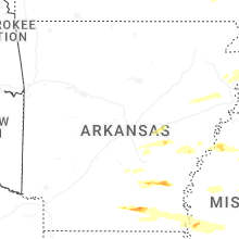
Arkansas
| Local Time | Report Details |
|---|---|
| 2:19 PM CDT | Quarter sized hail reported near Stuttgart, AR, 44.7 miles ESE of Little Rock, AR, report from mping: quarter (1.00 in.). |
| 2:20 PM CDT | Hen Egg sized hail reported near Stuttgart, AR, 44.7 miles ESE of Little Rock, AR, saw a picture of a 2 inch hailstone next to a ruler on a local broadcast media social media page. |
| 2:21 PM CDT | Quarter sized hail reported near Stuttgart, AR, 44.4 miles ESE of Little Rock, AR, report from mping: quarter (1.00 in.). |
| 2:30 PM CDT | Karhumph3 weather station recorded a 66 mph wind gust when the storm moved through the area at 2:30 pm cd in arkansas county AR, 41.2 miles ESE of Little Rock, AR |
| 2:44 PM CDT | Golf Ball sized hail reported near Wynne, AR, 41.7 miles W of Memphis, TN, golf ball sized hail on falls blvd. time is radar estimated. |
| 3:19 PM CDT | Half Dollar sized hail reported near , , 35 miles N of Memphis, TN, half dollar sized hail at big river steel. |
| 3:23 PM CDT | Quarter sized hail reported near Saint Charles, AR, 69.8 miles ESE of Little Rock, AR, report from mping: quarter (1.00 in.). |
| 3:24 PM CDT | Several power poles down across highway 14 between marie and wilso in mississippi county AR, 30.4 miles N of Memphis, TN |
| 3:27 PM CDT | Half Dollar sized hail reported near Dumas, AR, 70.2 miles SSE of Little Rock, AR, southeast lincoln county fire and rescue shared a picture of measured 1.25 inch hail in chat. |
| 4:07 PM CDT | Quarter sized hail reported near Hamburg, AR, 37 miles N of Bastrop, LA |
| 4:17 PM CDT | Power line dow in ashley county AR, 42.7 miles NNE of Bastrop, LA |
| 5:16 PM CDT | Tree downed across southbound lane of us 65. possible tornad in chicot county AR, 47.9 miles NE of Bastrop, LA |
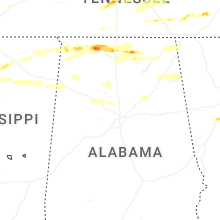
Alabama
| Local Time | Report Details |
|---|---|
| 2:22 PM CDT | A tree knocked down in the roadway. took out several power lines with road completely blocked along lockhart roa in morgan county AL, 50.5 miles ESE of Florence, AL |
| 4:27 PM CDT | Golf ball size observed hail along elk river ese of rogersville. time estimated from rada in lauderdale county AL, 24.8 miles E of Florence, AL |
| 4:39 PM CDT | 911 call center reported a tree down at 1165 lair ln in colbert count in colbert county AL, 16.6 miles WSW of Florence, AL |
| 4:53 PM CDT | Golf Ball sized hail reported near Cherokee, AL, 17 miles W of Florence, AL, american red cross reported golf ball sized hail in cherokee al. |
| 4:59 PM CDT | 911 call center reports a tree down on natchez track parkway... 2 miles south of hwy 7 in colbert county AL, 21.2 miles WSW of Florence, AL |
| 5:06 PM CDT | 911 call center reported a tree down on a house at 407 annapolis ave in sheffield a in colbert county AL, 2.9 miles SSW of Florence, AL |
| 5:10 PM CDT | Quarter sized hail reported near Florence, AL, 2.7 miles N of Florence, AL, ema reported quarter sized hail at florence highschool. |
| 5:12 PM CDT | Ping Pong Ball sized hail reported near Florence, AL, 4.9 miles N of Florence, AL, social media report of 1.5 inch hail at helton dr in florence al. |
| 5:12 PM CDT | Numerous trees down at exit 347 off of i-65 in limestone count in limestone county AL, 42.1 miles E of Florence, AL |
| 5:15 PM CDT | 911 center reports a tree down at 3104 ne 19th ave in sheffield a in colbert county AL, 2.3 miles SSW of Florence, AL |
| 5:20 PM CDT | 911 call center reports tree down at 1611 tennessee st sheffield a in colbert county AL, 2.1 miles S of Florence, AL |
| 5:21 PM CDT | Baseball-size hail along the tennessee river at joe wheeler state park. time estimated from rada in lawrence county AL, 16.8 miles E of Florence, AL |
| 5:22 PM CDT | Baseball sized hail reported near Town Creek, AL, 18.6 miles E of Florence, AL, baseball size hail reported in freeman acres community of lawrence county. |
| 5:22 PM CDT | Tree down on a house in ford cit in colbert county AL, 8.3 miles E of Florence, AL |
| 5:23 PM CDT | Tree down on a camper at the big nance mobile home park hwy 10 in lawrence county AL, 16.3 miles E of Florence, AL |
| 5:23 PM CDT | 911 call center reported tree down on powerlines at 1405 york st in sheffiel in colbert county AL, 2.1 miles S of Florence, AL |
| 5:23 PM CDT | 911 call center reported a tree down at 720 gargis hollow rd in muscle shoals a in colbert county AL, 10 miles E of Florence, AL |
| 5:24 PM CDT | Several trees down... power lines down... and damage to roof tops on homes and barns in the red bank community north of town creek. time estimated from rada in lawrence county AL, 17.5 miles E of Florence, AL |
| 5:26 PM CDT | Social media report of trees down in downtown sheffield a in colbert county AL, 3.1 miles SSW of Florence, AL |
| 5:32 PM CDT | Multiple power poles and trees down cr 605 in the rogersville area. time estimated by rada in lauderdale county AL, 21.4 miles E of Florence, AL |
| 5:34 PM CDT | Power poles and trees down on county road 389 north of alabama highway 20. time estimated from rada in lawrence county AL, 22.9 miles ESE of Florence, AL |
| 5:35 PM CDT | Golf Ball sized hail reported near Rogersville, AL, 24.8 miles E of Florence, AL, ema reported golf ball sized hail on hwy 72 at the elk river. |
| 5:38 PM CDT | Baseball sized hail reported near Town Creek, AL, 16.4 miles E of Florence, AL, ema reported baseball size hail in the red bank area south of wheeler dam. |
| 5:38 PM CDT | Tea Cup sized hail reported near Town Creek, AL, 16.3 miles ESE of Florence, AL, picture of 3 inch hail in town creek. |
| 5:42 PM CDT | Trees and power lines down along little elk road. time estimated from rada in limestone county AL, 25.3 miles E of Florence, AL |
| 5:44 PM CDT | Quarter sized hail reported near Rogersville, AL, 21.7 miles ENE of Florence, AL, report from mping: quarter (1.00 in.). |
| 6:04 PM CDT | Tree down at hwy 72 and glaze rd. timer estimated from rada in limestone county AL, 36.1 miles E of Florence, AL |
| 6:09 PM CDT | Tree down on hine street south. time estimated from rada in limestone county AL, 39.6 miles E of Florence, AL |
| 6:09 PM CDT | Power lines down along grisby lane and brownsferry roads. time estimated from rada in limestone county AL, 37.3 miles E of Florence, AL |
| 6:10 PM CDT | Multiple downed power poles and poles snapped on lucas ferry rd just south of hwy 7 in limestone county AL, 38.4 miles E of Florence, AL |
| 6:12 PM CDT | Tree down on a house behind the staples in athens. time estimated from rada in limestone county AL, 41.3 miles E of Florence, AL |
| 6:12 PM CDT | Several trees and powerlines down along sanderfer rd. time estimated from rada in limestone county AL, 39 miles E of Florence, AL |
| 6:20 PM CDT | Several reports of trees and lines down on mooresville road near greenbrier pkwy. time estimated by rada in limestone county AL, 45.6 miles E of Florence, AL |
| 6:26 PM CDT | Golf Ball sized hail reported near Tanner, AL, 41 miles E of Florence, AL, golfball size hail reported near tanner. time estimated by radar. |
| 6:30 PM CDT | Numerous trees down near west madison elementary school and the sage trails apartments on wall-triana highway in madiso in madison county AL, 52.9 miles E of Florence, AL |
| 6:39 PM CDT | Half Dollar sized hail reported near Athens, AL, 46.5 miles E of Florence, AL, report from mping: half dollar (1.25 in.). |
| 6:40 PM CDT | Quarter sized hail reported near Madison, AL, 54.9 miles E of Florence, AL, quarter size hail reported at shelton rd and madison blvd. |
| 6:40 PM CDT | Tree through a house in the area of wedgewood terrace road and nick davis. time estimated by rada in madison county AL, 53.8 miles E of Florence, AL |
| 6:40 PM CDT | Tree down on house on glenmore d in madison county AL, 54.3 miles E of Florence, AL |
| 6:41 PM CDT | Golf Ball sized hail reported near Athens, AL, 39.3 miles E of Florence, AL, report from mping: golf ball (1.75 in.). |
| 6:44 PM CDT | Quarter sized hail reported near Madison, AL, 53.1 miles E of Florence, AL, quarter sized hail reported on sullivan st in madison. |
| 6:45 PM CDT | Large tree snappe in madison county AL, 60.3 miles E of Florence, AL |
| 6:45 PM CDT | Quarter sized hail reported near Madison, AL, 51.7 miles E of Florence, AL, report from mping: quarter (1.00 in.). |
| 6:45 PM CDT | Quarter sized hail reported near Madison, AL, 51 miles E of Florence, AL, report from mping: quarter (1.00 in.). |
| 6:47 PM CDT | Trees down on vehicle in madison county AL, 64.1 miles E of Florence, AL |
| 6:47 PM CDT | Tree down. time estimated from rada in madison county AL, 65.3 miles E of Florence, AL |
| 6:48 PM CDT | Half Dollar sized hail reported near Madison, AL, 52.7 miles E of Florence, AL, spotter reported half dollar size hail at the lowes on highway 73. |
| 6:51 PM CDT | Quarter sized hail reported near Madison, AL, 55.1 miles E of Florence, AL, report from mping: quarter (1.00 in.). |
| 6:54 PM CDT | Ping Pong Ball sized hail reported near Huntsville, AL, 62.6 miles E of Florence, AL, pong pong sized hail reported at huntsville high school. time estimated by radar. |
| 6:54 PM CDT | Hen Egg sized hail reported near Huntsville, AL, 62.1 miles E of Florence, AL, egg size hail near the intersection of bob wallace and memorial parkway in huntsville. |
| 6:55 PM CDT | Quarter sized hail reported near Madison, AL, 51 miles E of Florence, AL, report from mping: quarter (1.00 in.). |
| 6:57 PM CDT | Baseball sized hail reported near Huntsville, AL, 63.9 miles E of Florence, AL, baseball hail near southwood church along carl t jones drive in the jones valley area of huntsville. |
| 6:57 PM CDT | Golf Ball sized hail reported near Huntsville, AL, 63.8 miles E of Florence, AL, golfball hail along drake road in se huntsville. |
| 6:58 PM CDT | Tree on power lines with one line dow in morgan county AL, 47.9 miles ESE of Florence, AL |
| 6:59 PM CDT | Hen Egg sized hail reported near Athens, AL, 45.4 miles E of Florence, AL, report from mping: hen egg (2.00 in.). |
| 7:02 PM CDT | Golf Ball sized hail reported near Huntsville, AL, 61 miles E of Florence, AL, report from mping: golf ball (1.75 in.). |
| 7:03 PM CDT | Power lines down at the intersection of brock road and hwy 72. time estimated by rada in madison county AL, 67.3 miles WSW of Chattanooga, TN |
| 7:05 PM CDT | Half Dollar sized hail reported near Huntsville, AL, 61 miles E of Florence, AL, report from mping: half dollar (1.25 in.). |
| 7:08 PM CDT | Power line down in hodges. time estimated from rada in franklin county AL, 36.2 miles SSW of Florence, AL |
| 7:08 PM CDT | Several structures collapsed/power lines and trees down in the area of kilingsworth cove road and jb hawkins road. time estimated by rada in madison county AL, 62.6 miles WSW of Chattanooga, TN |
| 7:10 PM CDT | Quarter sized hail reported near Madison, AL, 55.2 miles ESE of Florence, AL, quarter sized hail reported in triana. time estimated from radar. |
| 7:10 PM CDT | Quarter sized hail reported near Owens Cross Roads, AL, 69 miles WSW of Chattanooga, TN, report from mping: quarter (1.00 in.). |
| 7:10 PM CDT | Golf Ball sized hail reported near Huntsville, AL, 64.3 miles E of Florence, AL |
| 7:12 PM CDT | Half Dollar sized hail reported near Madison, AL, 54.8 miles ESE of Florence, AL, report from mping: half dollar (1.25 in.). |
| 7:13 PM CDT | Intersection of hwy 65 and county road 10 blocked due to numerous trees down. time estimated from rada in jackson county AL, 60.3 miles WSW of Chattanooga, TN |
| 7:14 PM CDT | Half Dollar sized hail reported near Huntsville, AL, 65.3 miles E of Florence, AL, report from mping: half dollar (1.25 in.). |
| 7:15 PM CDT | Ping Pong Ball sized hail reported near Huntsville, AL, 62.6 miles E of Florence, AL, report from mping: ping pong ball (1.50 in.). |
| 7:18 PM CDT | Broken power pole and lines down on cr 2 in jackson county AL, 54.8 miles WSW of Chattanooga, TN |
| 7:25 PM CDT | Powerlines down on hwy 79 in skyline. time estimated by rada in jackson county AL, 48.8 miles WSW of Chattanooga, TN |
| 7:38 PM CDT | Golf Ball sized hail reported near Owens Cross Roads, AL, 71.3 miles ESE of Florence, AL, golfball size hail reported at owens cross roads. |
| 7:57 PM CDT | Multiple trees down blocking both lanes on cr in jackson county AL, 63.7 miles WSW of Chattanooga, TN |
| 8:00 PM CDT | Tree down and road blockag in morgan county AL, 45.1 miles SE of Florence, AL |
| 8:02 PM CDT | Multiple trees down along hwy 71 in flat rock. time estimated from rada in jackson county AL, 29.2 miles SW of Chattanooga, TN |
| 8:09 PM CDT | Tree and power lines dow in morgan county AL, 47.5 miles ESE of Florence, AL |
| 8:10 PM CDT | Tree down on a hous in morgan county AL, 43.7 miles ESE of Florence, AL |
| 8:10 PM CDT | Tree down and road blockag in morgan county AL, 46.7 miles ESE of Florence, AL |
| 8:10 PM CDT | Tree and power lines dow in morgan county AL, 46.2 miles ESE of Florence, AL |
| 8:10 PM CDT | Tree down causing a total road blockag in morgan county AL, 45.2 miles ESE of Florence, AL |
| 8:15 PM CDT | Tree down in front of falkville heath care... road impassabl in morgan county AL, 52.8 miles SE of Florence, AL |
| 8:22 PM CDT | Tree down and road blockag in morgan county AL, 55.8 miles N of Birmingham, AL |
| 8:23 PM CDT | Power lines down resulting in a fire in nearby wood in morgan county AL, 55.4 miles SE of Florence, AL |
| 8:24 PM CDT | Social media report of trees and power lines down across highway 17 near luster place rd with the highway blocke in marion county AL, 53.3 miles SSW of Florence, AL |
| 8:37 PM CDT | Tree down on home. time estimated from rada in jackson county AL, 52.6 miles SW of Chattanooga, TN |
| 8:45 PM CDT | Tree down and road blockag in morgan county AL, 63.8 miles N of Birmingham, AL |
| 8:45 PM CDT | Tree down and road blockag in morgan county AL, 58.8 miles N of Birmingham, AL |
| 8:46 PM CDT | Tree and power lines dow in morgan county AL, 65.4 miles NNE of Birmingham, AL |
| 8:46 PM CDT | Tree down and road blockage. time estimated from rada in morgan county AL, 65.3 miles N of Birmingham, AL |
| 8:46 PM CDT | Power lines dow in morgan county AL, 64.9 miles NNE of Birmingham, AL |
| 8:47 PM CDT | Half Dollar sized hail reported near Scottsboro, AL, 55.9 miles WSW of Chattanooga, TN, report from mping: half dollar (1.25 in.). |
| 8:48 PM CDT | Tree down and road blockag in marshall county AL, 65.4 miles NNE of Birmingham, AL |
| 8:48 PM CDT | Tree down and road blockag in marshall county AL, 65.1 miles NNE of Birmingham, AL |
| 8:48 PM CDT | Tree down and road blockag in marshall county AL, 65.8 miles NNE of Birmingham, AL |
| 8:57 PM CDT | Trees and power lines down on feemster gap r in marshall county AL, 55.1 miles NNE of Birmingham, AL |
| 8:59 PM CDT | Tree down on brock chapel r in marshall county AL, 66 miles NNE of Birmingham, AL |
| 9:05 PM CDT | Trees down along cr 67... hwy 71... cr 372... cr 156. time estimated from rada in jackson county AL, 48.1 miles SW of Chattanooga, TN |
| 9:09 PM CDT | Trees down in the townley are in walker county AL, 41.5 miles WNW of Birmingham, AL |
| 9:18 PM CDT | Trees were downed in the mccollum area along highway 12 in walker county AL, 36.3 miles NW of Birmingham, AL |
| 9:32 PM CDT | Trees were downed in the sipsey are in walker county AL, 26.2 miles NW of Birmingham, AL |
| 10:00 PM CDT | Trees and power lines downed along cr 43... cr 53... and cr 36 in cherokee county AL, 58.6 miles SSW of Chattanooga, TN |
| 10:04 PM CDT | Trees and power lines down on cr 137 and cr 7 in cherokee county AL, 56.9 miles SSW of Chattanooga, TN |
| 10:10 PM CDT | Trees and power lines down along cr 114 and cr 4 in cherokee county AL, 53.9 miles SSW of Chattanooga, TN |
| 11:02 PM CDT | Several trees and tree limbs down on cr 26 west of ragland. much of ragland without powe in st. clair county AL, 37.8 miles ENE of Birmingham, AL |
| 11:21 PM CDT | Power lines down in the boiling springs are in calhoun county AL, 47.5 miles ENE of Birmingham, AL |
| 11:35 PM CDT | Numerous trees and power lines down across calhoun county from south of ohatchee to near saks and fort mcclellan. some trees fell on homes or blocked road in calhoun county AL, 55.8 miles ENE of Birmingham, AL |
| 12:07 AM CDT | Tree down on highway 46 and evans bridge rd in hefli in cleburne county AL, 68.2 miles W of Atlanta, GA |
| 12:30 AM CDT | Several reports of damage around cr 67... cr 95... and cr 611. one home was reported to have roof damag in cleburne county AL, 57.2 miles WSW of Atlanta, GA |
South Carolina
| Local Time | Report Details |
|---|---|
| 3:25 PM EDT | Quarter sized hail reported near Turbeville, SC, 45.8 miles N of Charleston, SC, clarendon county dispatch received a report of quarter sized hail near the intersection of coker rd and hicks rd... se of turbeville. |
| 6:52 PM EDT | Quarter sized hail reported near Gaffney, SC, 46.8 miles WSW of Charlotte, NC, mostly pea-sized hail... but some up to quarters. |
| 1:59 AM EDT | Down powerline in pickens county SC, 16.5 miles W of Greenville, SC |
| 2:08 AM EDT | Tree branches on powerline in greenville county SC, 15.1 miles SE of Greenville, SC |
Missouri
| Local Time | Report Details |
|---|---|
| 3:27 PM CDT | Quarter sized hail reported near Bethany, MO, 83.7 miles NNE of Kansas City, MO, social media report. time estimated from radar. |
Virginia
| Local Time | Report Details |
|---|---|
| 5:18 PM EDT | Trees down. time estimated by radar. time estimated by rada in wise county VA, 34.2 miles WNW of Bristol, TN |
| 6:00 PM EDT | Trees down and reports of hail. hail size unknow in washington county VA, 14.7 miles NE of Bristol, TN |
| 11:56 PM EDT | Tree down along bad rd in dickenson county VA, 31.1 miles NNW of Bristol, TN |
| 12:02 AM EDT | Tree damage resulting in 80 customers without powe in dickenson county VA, 41.5 miles N of Bristol, TN |
Texas
| Local Time | Report Details |
|---|---|
| 5:18 PM CDT | Quarter sized hail reported near Devers, TX, 50.4 miles ENE of Houston, TX |
Louisiana
| Local Time | Report Details |
|---|---|
| 6:13 PM CDT | Quarter sized hail reported near Tullos, LA, 70.8 miles SSW of Bastrop, LA, public reports quarter size hail in the tansey community via broadcast media fb page. |
| 6:15 PM CDT | Golf Ball sized hail reported near Tullos, LA, 70.4 miles SSW of Bastrop, LA, photos of hail ranging from quarter to golf ball in and around the tullos area. |
| 6:25 PM CDT | Ping Pong Ball sized hail reported near Urania, LA, 66.8 miles SSW of Bastrop, LA, reported in the beechwood loop area of urania. |
| 7:05 PM CDT | Corrects previous tstm wnd dmg report from 1 ene manifes in catahoula county LA, 73.6 miles S of Bastrop, LA |
| 7:10 PM CDT | Several trees down across highway 923 address 214 in catahoula county LA, 75.7 miles S of Bastrop, LA |
| 8:30 PM CDT | Powerlines and trees dow in concordia county LA, 89.6 miles NNE of Lafayette, LA |
| 8:30 PM CDT | Down trees on highway 90 in concordia county LA, 84.9 miles N of Lafayette, LA |
| 9:15 PM CDT | Quarter sized hail reported near Trout, LA, 79.3 miles SSW of Bastrop, LA, public report quarter size hail in the belah community via broadcast media fb page. |
| 9:26 PM CDT | Quarter sized hail reported near Effie, LA, 70.1 miles N of Lafayette, LA, estimated quarter size hail. |
| 9:28 PM CDT | Quarter sized hail reported near Effie, LA, 69.8 miles N of Lafayette, LA, estimated quarter to half dollar sized hail fell in vick. |
Georgia
| Local Time | Report Details |
|---|---|
| 10:26 PM EDT | Multiple trees along houston valley roa in whitfield county GA, 21.8 miles SE of Chattanooga, TN |
| 10:45 PM EDT | Large tree across the road near the intersection of highway 157 and valley view ranch roa in chattooga county GA, 32.3 miles SSW of Chattanooga, TN |
| 10:50 PM EDT | Tree on a powerline along peach orchard road near menl in chattooga county GA, 32.9 miles SSW of Chattanooga, TN |
| 10:55 PM EDT | Tree in the road at haig mill lake road and north bypass blocking the southbound lan in whitfield county GA, 24.9 miles SE of Chattanooga, TN |
| 10:57 PM EDT | Downed tree near the intersection of deforest avenue and allgood stree in chattooga county GA, 34.9 miles S of Chattanooga, TN |
| 11:00 PM EDT | 1 to 2 trees down and powerlines down along edison stree in chattooga county GA, 39.6 miles SSW of Chattanooga, TN |
| 11:00 PM EDT | Tree on a home near the intersection of ridge street and allgood stree in chattooga county GA, 34.9 miles S of Chattanooga, TN |
| 11:45 PM EDT | Storm damage reported in bartow county GA, 51.3 miles SSE of Chattanooga, TN |
| 12:08 AM EDT | Several trees down near hwy 140 and garland mountain roa in cherokee county GA, 43.2 miles NNW of Atlanta, GA |
| 12:08 AM EDT | Tree reported down on a power line on mckelvey d in polk county GA, 40.6 miles WNW of Atlanta, GA |
| 12:38 AM EDT | Trees have fallen on 2 different homes near the intersection of dena drive and mills wood ru in cherokee county GA, 31.3 miles NNW of Atlanta, GA |
| 12:48 AM EDT | Ham radio operator reported a tree down at a residence near pilgrim mill road and faa roa in forsyth county GA, 36.8 miles NNE of Atlanta, GA |
| 2:56 AM EDT | Ping Pong Ball sized hail reported near Tyrone, GA, 19.7 miles SSW of Atlanta, GA, public report of 1.5 inch hail in the river crest neighborhood in tyrone. |
| 3:42 AM EDT | Tree reported down at the intersection of amelia rd and apple r in spalding county GA, 31.8 miles SSE of Atlanta, GA |
| 3:48 AM EDT | Emergency manager relayed report of a tree down on plaza driv in butts county GA, 36.7 miles SE of Atlanta, GA |
| 3:50 AM EDT | Emergency manager reported a down tree on halls bridge road. estimated locatio in butts county GA, 41.4 miles SE of Atlanta, GA |
| 4:55 AM EDT | Georgia power website reported power outages on morris calloway road due to a fallen tree. time estimated by rada in columbia county GA, 22 miles W of Augusta, GA |
North Carolina
| Local Time | Report Details |
|---|---|
| 1:22 AM EDT | Tree down on cannon av in forsyth county NC, 69.9 miles NNE of Charlotte, NC |
| 1:35 AM EDT | Trees down on power equipmen in forsyth county NC, 72.4 miles NNE of Charlotte, NC |
| 1:36 AM EDT | Tree down on powerline in forsyth county NC, 74.5 miles NNE of Charlotte, NC |
| 3:30 AM EDT | Tree down on roa in mecklenburg county NC, 5.9 miles SSE of Charlotte, NC |
| 3:30 AM EDT | Tree down on roa in mecklenburg county NC, 7.1 miles ESE of Charlotte, NC |
Connect with Interactive Hail Maps