

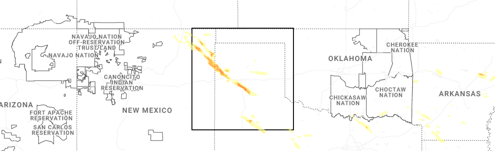
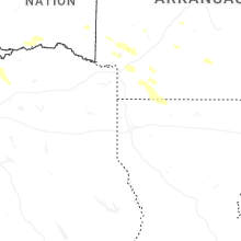
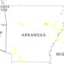
Hail Map for Saturday, June 7, 2025
Number of Impacted Households on 6/7/2025
0
Impacted by 1" or Larger Hail
0
Impacted by 1.75" or Larger Hail
0
Impacted by 2.5" or Larger Hail
Square Miles of Populated Area Impacted on 6/7/2025
0
Impacted by 1" or Larger Hail
0
Impacted by 1.75" or Larger Hail
0
Impacted by 2.5" or Larger Hail


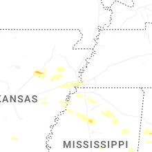

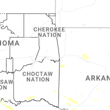

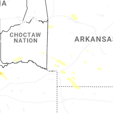
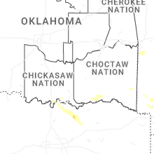
Cities Most Affected by Hail Storms of 6/7/2025
| Hail Size | Demographics of Zip Codes Affected | ||||||
|---|---|---|---|---|---|---|---|
| City | Count | Average | Largest | Pop Density | House Value | Income | Age |
| Dalhart, TX | 2 | 2.38 | 2.50 | 5 | $63k | $33.1k | 36.5 |
| Clayton, NM | 2 | 1.88 | 2.00 | 2 | $51k | $27.5k | 39.8 |
| Lorenzo, TX | 2 | 1.75 | 1.75 | 6 | $37k | $29.1k | 35.4 |
| Canyon, TX | 1 | 2.00 | 2.00 | 49 | $91k | $35.7k | 29.2 |
| Grenville, NM | 1 | 1.75 | 1.75 | 0 | $103k | $26.3k | 46.3 |
| Sedan, NM | 1 | 1.75 | 1.75 | 2 | $45k | $31.5k | 43.3 |
| Amistad, NM | 1 | 1.75 | 1.75 | 0 | $54k | $41.9k | 47.2 |
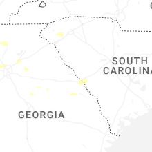
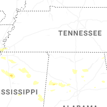
Hail and Wind Damage Spotted on 6/7/2025
Filter by Report Type:Hail ReportsWind Reports
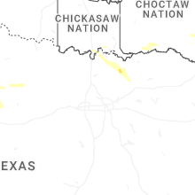
States Impacted
Arkansas, Tennessee, Mississippi, Alabama, Georgia, North Carolina, South Dakota, New Mexico, North Dakota, South Carolina, Missouri, Texas, VirginiaArkansas
| Local Time | Report Details |
|---|---|
| 7:11 AM CDT | Numerous trees reported down in the clarksville area with multiple trees blocking arkansas highway 16 in johnson county AR, 59.8 miles E of Fort Smith, AR |
| 7:17 AM CDT | Numerous trees reported down across the county with portions of arkansas highway 7 blocked with downed tree in newton county AR, 79.1 miles ENE of Fort Smith, AR |
| 7:32 AM CDT | Multiple trees reported down along ar-highway 7 near the pope/newton county lin in pope county AR, 76.4 miles NW of Little Rock, AR |
| 7:41 AM CDT | Local police dispatch reported several trees down along arkansas highway 80 east of waldro in scott county AR, 43.2 miles SE of Fort Smith, AR |
| 8:13 AM CDT | Multiple trees reported blown down in the community of rove in yell county AR, 65.1 miles ESE of Fort Smith, AR |
| 8:14 AM CDT | A large tree limb fell through a home near this location near rover. no injuries reporte in yell county AR, 65 miles ESE of Fort Smith, AR |
| 8:32 AM CDT | Numerous trees down across cleburne county with several blocking road in cleburne county AR, 47.8 miles N of Little Rock, AR |
| 8:56 AM CDT | Large tree across road on n 15th st. & cedar st. near the library. time estimate in crawford county AR, 6 miles NE of Fort Smith, AR |
| 8:58 AM CDT | Powerlines down via social media picture in the community of judsoni in white county AR, 51.3 miles NE of Little Rock, AR |
| 9:02 AM CDT | Tree down on old stagecoach road in southwestern little roc in pulaski county AR, 8.6 miles WSW of Little Rock, AR |
| 9:07 AM CDT | Multiple trees reported down near hickory plain in prairie county AR, 33.2 miles ENE of Little Rock, AR |
| 9:14 AM CDT | Several reports of large limbs down in sherwoo in pulaski county AR, 7.4 miles NE of Little Rock, AR |
| 9:17 AM CDT | Tree down at the intersection of orange and quapaw with power lines down and blocking orange street in hot spring in garland county AR, 47.7 miles WSW of Little Rock, AR |
| 9:46 AM CDT | Trees reported blown dow in monroe county AR, 64.9 miles ESE of Little Rock, AR |
| 10:25 AM CDT | Reported downed trees and tree on home at the 300 block of waverly rd in helena... ar. time estimated on rada in phillips county AR, 53.1 miles SW of Memphis, TN |
| 8:54 PM CDT | Report of trees down near us 371 and liggin drive east of lockesbur in sevier county AR, 17.4 miles W of Nashville, AR |
| 9:35 PM CDT | Reports of trees down in the mineral springs area with at least one report on north pine street in tow in howard county AR, 6.3 miles SW of Nashville, AR |
| 10:06 PM CDT | Reports of trees and powerlines dow in hempstead county AR, 16.5 miles SSE of Nashville, AR |
| 10:38 PM CDT | Reports of trees and powerlines down all over the town of hop in hempstead county AR, 25.3 miles SE of Nashville, AR |
| 12:52 AM CDT | Reports of a tree down in lewisvill in lafayette county AR, 43.3 miles SSE of Nashville, AR |
Tennessee
| Local Time | Report Details |
|---|---|
| 10:07 AM CDT | Large tree down on highway 70 near aztec drive in gallawa in fayette county TN, 26.4 miles ENE of Memphis, TN |
| 10:55 AM CDT | Tree down in bolivar. several other reports across the county of trees down outside of tow in hardeman county TN, 60.4 miles E of Memphis, TN |
| 2:24 PM CDT | Ema reported several trees down and powerlines down in the coldwater area of lincoln county tennessee. time estimated by rada in lincoln county TN, 57 miles ENE of Florence, AL |
| 2:42 PM CDT | Ema reported several trees and powerlines down in the flintville area of lincoln county. time estimated by rada in lincoln county TN, 63 miles W of Chattanooga, TN |
| 2:45 PM CDT | Tspotter report of powerlines and poles down near the intersection of wartrace pike and lingon drive in shelbyville. time is radar estimate in bedford county TN, 51.5 miles SSE of Nashville, TN |
| 3:00 PM CDT | Tspotter report of power lines in road from a tree that fell on clements drive in tullahom in coffee county TN, 55.1 miles WNW of Chattanooga, TN |
| 3:02 PM CDT | Tspotter report of a large tree down at maplewood cemetery in tullahom in coffee county TN, 55.1 miles WNW of Chattanooga, TN |
| 3:21 PM CDT | Facebook photo received of a large tree down at the intersection of bud pattie road and summertown road. time is radar estimate in grundy county TN, 30.9 miles WNW of Chattanooga, TN |
| 3:26 PM CDT | Facebook report received of clouse hill road completely blocked by downed tree. time is radar estimate in grundy county TN, 32.4 miles WNW of Chattanooga, TN |
| 3:28 PM CDT | Facebook report received of a tree down blocking the intersection of fremont road and highway 56 in coalmon in grundy county TN, 30.4 miles NW of Chattanooga, TN |
| 3:35 PM CDT | Social media of photos of trees down in the whiteside are in marion county TN, 13.1 miles W of Chattanooga, TN |
| 3:45 PM CDT | Social media images of large trees uproote in sequatchie county TN, 22.8 miles NNW of Chattanooga, TN |
| 4:48 PM EDT | Social media images of large trees snapped at trunk on mountain creek roa in hamilton county TN, 5.8 miles N of Chattanooga, TN |
| 4:50 PM EDT | Social media videos of trees uproote in hamilton county TN, 4.4 miles N of Chattanooga, TN |
| 5:00 PM EDT | Approximately 3 inch diameter trees snapped at trun in hamilton county TN, 14.5 miles ENE of Chattanooga, TN |
| 5:05 PM EDT | 10 inch tree branches snappe in hamilton county TN, 15.9 miles E of Chattanooga, TN |
| 5:08 PM EDT | Power outage... multiple trees down... heavy wind gust in hamilton county TN, 22.3 miles NE of Chattanooga, TN |
| 5:18 PM EDT | Social media pictures of trees down across the roa in bradley county TN, 25.2 miles ENE of Chattanooga, TN |
Mississippi
| Local Time | Report Details |
|---|---|
| 10:24 AM CDT | Trees down and damage to a church in the vicinity of maude rd... cow oak rd... and dubbs roa in tunica county MS, 45.5 miles SSW of Memphis, TN |
| 10:55 AM CDT | A couple of trees down on hwy 310 including cr 504 and cr 51 in lafayette county MS, 48.1 miles SSE of Memphis, TN |
| 11:17 AM CDT | Multiple trees down around the oxford area... including cr 164... hwy 6 west... and east wells gate driv in lafayette county MS, 57.9 miles SSE of Memphis, TN |
| 11:20 AM CDT | Trees down on south lama in lafayette county MS, 63.4 miles SSE of Memphis, TN |
| 11:31 AM CDT | Trees down along cr 445 and hwy 33 in lafayette county MS, 65.8 miles NNW of Starkville, MS |
| 11:39 AM CDT | Large branches down on county road 45 in lafayette county MS, 59.2 miles NNW of Starkville, MS |
| 11:40 AM CDT | Trees and power lines down on esperanza road near hurrican in pontotoc county MS, 64.8 miles NNW of Starkville, MS |
| 11:48 AM CDT | Tree fell on vehicle on moss hill d in union county MS, 72.8 miles SE of Memphis, TN |
| 11:50 AM CDT | Trees down on highway 15 at union county lin in union county MS, 64.1 miles N of Starkville, MS |
| 11:57 AM CDT | Trees down at campground rd and brown l in pontotoc county MS, 50 miles N of Starkville, MS |
| 11:59 AM CDT | Trees down blocking road at twin lakes road and highway 4 in pontotoc county MS, 49.2 miles N of Starkville, MS |
| 12:00 PM CDT | Tree down across robertson roa in pontotoc county MS, 61 miles N of Starkville, MS |
| 12:00 PM CDT | Two campers overturned by wind in pontotoc county MS, 61 miles N of Starkville, MS |
| 12:00 PM CDT | Tree fell onto an outpost building and damaged the structur in union county MS, 64.5 miles N of Starkville, MS |
| 12:12 PM CDT | Tree down across maccomb av in lee county MS, 61.9 miles N of Starkville, MS |
| 12:13 PM CDT | Several trees snapped and uprooted off of cr 183 in tupel in lee county MS, 60.3 miles N of Starkville, MS |
| 12:17 PM CDT | Large tree down on hom in chickasaw county MS, 36.9 miles N of Starkville, MS |
| 12:21 PM CDT | Carport building and fence damaged in mariett in prentiss county MS, 49.5 miles WSW of Florence, AL |
| 12:21 PM CDT | Large tree downed on a structure in nettleto in lee county MS, 44.4 miles NNE of Starkville, MS |
| 12:33 PM CDT | Trees down in tow in monroe county MS, 42 miles NNE of Starkville, MS |
| 12:33 PM CDT | Trees down in the becker communit in monroe county MS, 37.3 miles NNE of Starkville, MS |
| 12:34 PM CDT | Trees and power lines dow in monroe county MS, 47.6 miles NNE of Starkville, MS |
| 12:34 PM CDT | Trees down... one landed on a pickup truck damaging the roof and breaking windows... in becke in monroe county MS, 37.3 miles NNE of Starkville, MS |
| 12:34 PM CDT | Tree down at tishomingo schoo in tishomingo county MS, 33.7 miles WSW of Florence, AL |
| 12:35 PM CDT | Minor roof damage reported to a home on williams young roa in monroe county MS, 45.6 miles NNE of Starkville, MS |
| 12:42 PM CDT | Large tree uproot and another large trunk snapped off of center hill r in monroe county MS, 30.5 miles NE of Starkville, MS |
| 12:42 PM CDT | Two trees were downed across ms hwy 50 between cedar bluff and pheb in clay county MS, 9.6 miles NNW of Starkville, MS |
| 12:50 PM CDT | Trees were downed in the city of west poin in clay county MS, 13.7 miles NE of Starkville, MS |
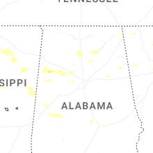
Alabama
| Local Time | Report Details |
|---|---|
| 12:45 PM CDT | Trees and power lines down in the detroit are in lamar county AL, 53.7 miles NE of Starkville, MS |
| 12:47 PM CDT | Trees and power lines down in the sulligent are in lamar county AL, 49.4 miles NE of Starkville, MS |
| 12:54 PM CDT | Trees and power lines down on a section of steele street in hamilto in marion county AL, 50.6 miles SSW of Florence, AL |
| 12:55 PM CDT | Trees and power lines down in the hamilton are in marion county AL, 48.7 miles SSW of Florence, AL |
| 12:59 PM CDT | Trees and power lines down in the vernon are in lamar county AL, 45.3 miles ENE of Starkville, MS |
| 1:00 PM CDT | Powerlines down in russellville... al resulting in power outages. time estimated based on rada in franklin county AL, 20.9 miles S of Florence, AL |
| 1:00 PM CDT | Power outages in russellville due to several power lines down due to severe thunderstorm wind in franklin county AL, 20.3 miles S of Florence, AL |
| 1:03 PM CDT | Multiple reports of trees and power lines down across marion county as well as some instances of structural damag in marion county AL, 46.2 miles S of Florence, AL |
| 1:03 PM CDT | Tree down on a house in gui in marion county AL, 58.8 miles SSW of Florence, AL |
| 1:09 PM CDT | Trees and power lines down in the brilliant are in marion county AL, 54.1 miles S of Florence, AL |
| 1:11 PM CDT | Trees down in the winfield are in marion county AL, 60.6 miles S of Florence, AL |
| 1:13 PM CDT | Trees and power lines down in the haleyville are in winston county AL, 38.8 miles S of Florence, AL |
| 1:18 PM CDT | Trees down on the west of of tuscumbi in colbert county AL, 5.2 miles SSW of Florence, AL |
| 1:22 PM CDT | Ema reported numerous trees downed off of bluffview shores road and butler creek road including one tree down on a shed. time estimated by rada in lauderdale county AL, 9.7 miles NNE of Florence, AL |
| 1:26 PM CDT | Ema reported a tree on a home along with large branches and trees uprooted in the shoals acres neighborhoo in lauderdale county AL, 8.6 miles NE of Florence, AL |
| 1:29 PM CDT | Trees and power lines down in the double springs are in winston county AL, 47.5 miles SSE of Florence, AL |
| 1:33 PM CDT | Several trees down in the bankhead national forest along highway 3 in lawrence county AL, 35.9 miles SSE of Florence, AL |
| 1:33 PM CDT | Trees down at the intersection of cr 460 and cr 229 in moulto in lawrence county AL, 31.1 miles SE of Florence, AL |
| 1:34 PM CDT | Ema reported several trees down on cr 90 just off of alabama highway 33. time estimated by rada in lawrence county AL, 35.1 miles SE of Florence, AL |
| 1:36 PM CDT | Trees down in the houston are in winston county AL, 49.9 miles NNW of Birmingham, AL |
| 1:37 PM CDT | Trees down in the arley are in winston county AL, 45.5 miles NNW of Birmingham, AL |
| 1:45 PM CDT | Trees down at the intersection of county road 170 and county road 21 in lawrence county AL, 32.5 miles ESE of Florence, AL |
| 1:45 PM CDT | Trees down in the jasper are in walker county AL, 34.4 miles NW of Birmingham, AL |
| 1:50 PM CDT | Tree down on mobile home on county road 940... south of the intersections with county roads 970 and 81 in cullman county AL, 43.7 miles NNW of Birmingham, AL |
| 1:50 PM CDT | Trees down in the area of highway 69 and arkadelphia roa in walker county AL, 31.1 miles NW of Birmingham, AL |
| 1:55 PM CDT | Multiple trees down on county rd 82 in cullman county AL, 41.7 miles NNW of Birmingham, AL |
| 2:00 PM CDT | Ema reported damage to a livestock farm structure and pole barn as well as a tree on a home. time estimated by rada in cullman county AL, 46.3 miles N of Birmingham, AL |
| 2:01 PM CDT | Large tree down on county rd 70 in cullman county AL, 43.4 miles N of Birmingham, AL |
| 2:02 PM CDT | Trees down on county road 1408 in cullma in cullman county AL, 48.2 miles N of Birmingham, AL |
| 2:03 PM CDT | Large branches and trees down in the sumiton are in walker county AL, 21 miles NW of Birmingham, AL |
| 2:03 PM CDT | Multiple locations of trees down across southern walker count in walker county AL, 26.2 miles WNW of Birmingham, AL |
| 2:03 PM CDT | Large tree branch down at county rd 140 in cullman county AL, 47.5 miles N of Birmingham, AL |
| 2:05 PM CDT | Tree down on missionary grove churc in cullman county AL, 47 miles N of Birmingham, AL |
| 2:08 PM CDT | Several structures damaged on county rd 73 in cullman county AL, 45 miles N of Birmingham, AL |
| 2:13 PM CDT | Tree on house on wesley r in cullman county AL, 50.2 miles N of Birmingham, AL |
| 2:13 PM CDT | Trees and power lines down in the birmingport are in jefferson county AL, 17.6 miles WNW of Birmingham, AL |
| 2:16 PM CDT | 50 kt wind gust reported at hsv intl airport aso in madison county AL, 51.6 miles ESE of Florence, AL |
| 2:18 PM CDT | Trees and power lines down in the hayden are in blount county AL, 26.4 miles N of Birmingham, AL |
| 2:18 PM CDT | Trees down in the blountsville are in blount county AL, 40.6 miles NNE of Birmingham, AL |
| 2:20 PM CDT | Trees down along highway 69 in fairview. very strong winds reported by trained spotte in cullman county AL, 50.9 miles N of Birmingham, AL |
| 2:21 PM CDT | Multiple tree and power line down reports across jefferson count in jefferson county AL, 11.9 miles WSW of Birmingham, AL |
| 2:21 PM CDT | Trees and power lines down in the concord are in jefferson county AL, 13.1 miles WSW of Birmingham, AL |
| 2:24 PM CDT | Huntsville asos at the hsv intl airport gusted to 60 mp in madison county AL, 52.7 miles ESE of Florence, AL |
| 2:27 PM CDT | Trees down in the center point are in jefferson county AL, 11.2 miles NE of Birmingham, AL |
| 2:27 PM CDT | Trim damage on the jep prep gas canopy with trees down in the area as wel in jefferson county AL, 6.2 miles N of Birmingham, AL |
| 2:28 PM CDT | Public report received of a large tree snapped down the middle off of monument lane in madison. time estimated by rada in madison county AL, 51.8 miles E of Florence, AL |
| 2:32 PM CDT | 61 mph gust at birmingham international airpor in jefferson county AL, 4.5 miles NE of Birmingham, AL |
| 2:32 PM CDT | Trees down in the oneonta are in blount county AL, 35.5 miles NNE of Birmingham, AL |
| 2:35 PM CDT | Tree down on the roof of a single family residence in hampton cov in madison county AL, 71 miles E of Florence, AL |
| 2:36 PM CDT | Trees and powerlines down near madison county nature trail in green mt in madison county AL, 67.2 miles ESE of Florence, AL |
| 2:36 PM CDT | Trees and powerlines down on green mountai in madison county AL, 67.1 miles E of Florence, AL |
| 2:36 PM CDT | Trees down along highway 278 in the altoona are in blount county AL, 46.9 miles NE of Birmingham, AL |
| 2:38 PM CDT | Trees down in the trussville are in jefferson county AL, 13.5 miles ENE of Birmingham, AL |
| 2:42 PM CDT | Trees down in the southern end of the county... including crossville... al. other nearby areas include county roads 82 and 75... and county rd 51 and hwy 22 in dekalb county AL, 65.9 miles SW of Chattanooga, TN |
| 2:43 PM CDT | Public report received via social media of several trees down on keel mountain road near the intersection of laurel lane. there was also one tree that fell on a home. t in madison county AL, 65.9 miles WSW of Chattanooga, TN |
| 2:43 PM CDT | Tree down on cr 20 near cr 10 in dekalb county AL, 65.9 miles SW of Chattanooga, TN |
| 2:44 PM CDT | Trees down in moody... some involving power line in st. clair county AL, 19.3 miles ENE of Birmingham, AL |
| 2:45 PM CDT | Powerlines down at county rd 63 and hwy 72... also trees down off county rd 63 near woodville high schoo in jackson county AL, 62.3 miles WSW of Chattanooga, TN |
| 2:46 PM CDT | Trees down in the moody area... at least one on a hom in st. clair county AL, 19.3 miles ENE of Birmingham, AL |
| 2:51 PM CDT | Trees down in the ashville are in st. clair county AL, 38.7 miles NE of Birmingham, AL |
| 2:52 PM CDT | Trees down on powerlines blocking the road at allen rd and al hwy 7 in jackson county AL, 53.4 miles WSW of Chattanooga, TN |
| 2:54 PM CDT | Large tree down blocking both lanes of county rd in jackson county AL, 63.8 miles WSW of Chattanooga, TN |
| 2:57 PM CDT | Trees down in the columbiana are in shelby county AL, 22.8 miles SSE of Birmingham, AL |
| 2:57 PM CDT | Trees down in the montevallo area... some involving power line in shelby county AL, 29.1 miles S of Birmingham, AL |
| 2:58 PM CDT | County rd 63... woodville fire advises tree down and also powerlines on the roa in jackson county AL, 50.7 miles WSW of Chattanooga, TN |
| 3:00 PM CDT | Trees and powerlines down... poles broken near bob jones rd on goose pond island; trees and powerlines reported down across scottsbor in jackson county AL, 52.6 miles SW of Chattanooga, TN |
| 3:00 PM CDT | Trees down in the chelsea are in shelby county AL, 16.3 miles SE of Birmingham, AL |
| 3:05 PM CDT | Multiple trees and powerlines down across hollywood... a in jackson county AL, 44.1 miles WSW of Chattanooga, TN |
| 3:09 PM CDT | Trees down in the lincoln are in talladega county AL, 40.4 miles E of Birmingham, AL |
| 3:15 PM CDT | Trees down in the cedar bluff are in cherokee county AL, 59.3 miles SSW of Chattanooga, TN |
| 3:15 PM CDT | Trees down in the centre are in cherokee county AL, 65.1 miles SSW of Chattanooga, TN |
| 3:15 PM CDT | Trees and power lines down in the gaylesville are in cherokee county AL, 55.4 miles SSW of Chattanooga, TN |
| 3:20 PM CDT | Multiple trees damage in scottsboro along hood ave... larry dr and byron r in jackson county AL, 50.2 miles WSW of Chattanooga, TN |
| 3:20 PM CDT | Ema reported a tree down on a home off of county road 407 near sylvania. time estimated by rada in dekalb county AL, 43.2 miles SW of Chattanooga, TN |
| 3:20 PM CDT | Trees down at various locations across calhoun county... some involving power line in calhoun county AL, 63.8 miles ENE of Birmingham, AL |
| 3:21 PM CDT | Tree and powerlines down on mobile home... county rd 13 in dekalb county AL, 33.8 miles SW of Chattanooga, TN |
| 3:21 PM CDT | Large tree down... possibly on a home on cr 13 in dekalb county AL, 34.1 miles SW of Chattanooga, TN |
| 3:21 PM CDT | Trees down in the talladega are in talladega county AL, 41.6 miles E of Birmingham, AL |
| 3:22 PM CDT | Ema reported several trees down in the sylvania area including carrisa road... 2nd street... and 3rd street. time estimated by rada in dekalb county AL, 44 miles SW of Chattanooga, TN |
| 3:23 PM CDT | Structural damage to a carport and tree damag in jackson county AL, 19.6 miles WSW of Chattanooga, TN |
| 3:28 PM CDT | Ema reported a tree down on a home off of county road 267 near bryant. time estimated by rada in jackson county AL, 20.7 miles WSW of Chattanooga, TN |
| 3:30 PM CDT | Tree down on a residenc in calhoun county AL, 60 miles E of Birmingham, AL |
| 3:31 PM CDT | Trees down in the sylacauga are in talladega county AL, 40.5 miles SE of Birmingham, AL |
| 3:35 PM CDT | Trees down in the munford are in talladega county AL, 49.7 miles E of Birmingham, AL |
| 3:35 PM CDT | Storm damage reported in talladega county AL, 44.1 miles E of Birmingham, AL |
| 4:15 PM CDT | A few trees down in the woodland are in randolph county AL, 53.4 miles N of Auburn, AL |
| 4:56 PM CDT | Trees and powerlines down on maddox rd... possibly on mobile hom in jackson county AL, 39.8 miles SW of Chattanooga, TN |
| 4:49 AM CDT | Report of tree down across the road. time estimated from rada in randolph county AL, 48.7 miles NNW of Auburn, AL |
Georgia
| Local Time | Report Details |
|---|---|
| 4:35 PM EDT | Tree and powerlines reported down on lyerly dam rd near the intersection with williams s in chattooga county GA, 44.9 miles S of Chattanooga, TN |
| 4:43 PM EDT | Tree down along creeks bend drive near the intersection at creeks bend lan in catoosa county GA, 15.6 miles SE of Chattanooga, TN |
| 4:45 PM EDT | Car trapped between two downed trees and downed powerlines near the intersection of braswell mountain rd and thomas rd. no injurie in paulding county GA, 34.5 miles WNW of Atlanta, GA |
| 4:47 PM EDT | Tree down in the road near the intersection of highway 41 and boofer roa in catoosa county GA, 11.2 miles SE of Chattanooga, TN |
| 4:50 PM EDT | A tree was downed onto a vehicle in the 500 block of north tibbs rd. no injurie in whitfield county GA, 26.8 miles SE of Chattanooga, TN |
| 4:50 PM EDT | A caller reported 2 trees were downed in the 90 block of donahoo roa in floyd county GA, 53.7 miles NW of Atlanta, GA |
| 4:51 PM EDT | Tree reported down in the roadway at the intersection of old three notch rd and three notch r in catoosa county GA, 13 miles SSE of Chattanooga, TN |
| 4:52 PM EDT | A tree was downed on north lakeshore drive at campbell roa in whitfield county GA, 20 miles SE of Chattanooga, TN |
| 4:52 PM EDT | A tree was downed in the 1300 block of mill creek rd s in whitfield county GA, 24.4 miles SE of Chattanooga, TN |
| 4:52 PM EDT | A tree was downed on woods point at stoney ru in whitfield county GA, 25.2 miles SE of Chattanooga, TN |
| 4:53 PM EDT | Tree reported down in the roadway on patricia ci in catoosa county GA, 9.1 miles SE of Chattanooga, TN |
| 4:55 PM EDT | A tree was downed on gin street at crown stree in whitfield county GA, 26.6 miles SE of Chattanooga, TN |
| 4:57 PM EDT | Tree reported down at the 400 block of mt. pisgah r in catoosa county GA, 15.2 miles SE of Chattanooga, TN |
| 5:00 PM EDT | Tree down across roadway on 1300 block of hutchings mountain r in polk county GA, 41.9 miles WNW of Atlanta, GA |
| 5:00 PM EDT | Tree reported down at the 100 block of bethlehem r in polk county GA, 46.4 miles WNW of Atlanta, GA |
| 5:00 PM EDT | Tree down on a home along avenue east near the intersection of avenue east and morningside driv in whitfield county GA, 26.6 miles SE of Chattanooga, TN |
| 5:00 PM EDT | A tree was downed on beaverdale rd ne at columbus wa in whitfield county GA, 26.7 miles ESE of Chattanooga, TN |
| 5:00 PM EDT | A tree was reported down near the intersection of sandy lane at salem valley roa in catoosa county GA, 16.1 miles SE of Chattanooga, TN |
| 5:00 PM EDT | Numerous snapped and uprooted trees along ramblewood drive in the silver creek communit in floyd county GA, 52.9 miles WNW of Atlanta, GA |
| 5:05 PM EDT | A tree was downed on golf view drive at drivers lan in whitfield county GA, 21.9 miles ESE of Chattanooga, TN |
| 5:05 PM EDT | A tree was downed on greeson bend road at conasauga wa in murray county GA, 31.4 miles SE of Chattanooga, TN |
| 5:08 PM EDT | A tree was downed on old dalton cleveland highway at hopewell roa in whitfield county GA, 22.2 miles ESE of Chattanooga, TN |
| 5:10 PM EDT | A tree was downed on red cut rd at highway 41 in murray county GA, 34 miles ESE of Chattanooga, TN |
| 5:10 PM EDT | A tree was downed on brown bridge rd at hwy 22 in murray county GA, 36.7 miles SE of Chattanooga, TN |
| 5:11 PM EDT | Tree reported down in the road on golden rd near allgood church r in paulding county GA, 38.1 miles WNW of Atlanta, GA |
| 5:12 PM EDT | A tree was downed on smyrna ramhurst rd at rymer r in murray county GA, 39.8 miles SE of Chattanooga, TN |
| 5:12 PM EDT | A tree was downed on peeples rd at holly creek cool springs roa in murray county GA, 37.2 miles ESE of Chattanooga, TN |
| 5:15 PM EDT | A tree was downed on richard bennett road at caylor roa in murray county GA, 31.9 miles ESE of Chattanooga, TN |
| 5:15 PM EDT | Tree reported down near the intersection of hwy 53 and bryant r in pickens county GA, 51.3 miles NNW of Atlanta, GA |
| 5:15 PM EDT | A tree was downed on hwy 225 at coffey church roa in murray county GA, 30.4 miles E of Chattanooga, TN |
| 5:16 PM EDT | Two trees and telephone pole reported down at the intersection of ridge rd and villa rica hw in paulding county GA, 29 miles W of Atlanta, GA |
| 5:17 PM EDT | Four live powerlines reported down in road on paul harris rd near the intersection with cumberland av in paulding county GA, 29.6 miles WNW of Atlanta, GA |
| 5:20 PM EDT | A tree was downed on carters dam road at marina roa in murray county GA, 48.1 miles SE of Chattanooga, TN |
| 5:21 PM EDT | Tree reported down at the intersection of overlook dr and golfers wa in douglas county GA, 28.7 miles W of Atlanta, GA |
| 5:23 PM EDT | Tree reported down near the intersection of village entrance rd and mann r in douglas county GA, 25.3 miles W of Atlanta, GA |
| 5:23 PM EDT | Tree reported down near the intersection of ridge rd and seals r in paulding county GA, 27.2 miles W of Atlanta, GA |
| 5:23 PM EDT | Tree reported down on powerlines near the intersection of corn crib loop and pocahontas d in douglas county GA, 24.7 miles W of Atlanta, GA |
| 5:25 PM EDT | Tree down on powerlines near post rd to the immediate north of i-2 in douglas county GA, 25.3 miles W of Atlanta, GA |
| 5:25 PM EDT | Tree on a home near the intersection of cobblestone ct and limestone ln. no injurie in paulding county GA, 25.4 miles W of Atlanta, GA |
| 5:25 PM EDT | Trees were downed and a power pole was broken on tails creek church roa in gilmer county GA, 44.2 miles ESE of Chattanooga, TN |
| 5:26 PM EDT | Tree reported down on a house near shore dr and skyline d in douglas county GA, 23.3 miles W of Atlanta, GA |
| 5:29 PM EDT | Tree reported down at the intersection of post rd and duncan memorial hw in douglas county GA, 28.4 miles WSW of Atlanta, GA |
| 5:29 PM EDT | Tree down on two vehicles near the intersection of indian creek dr and indian creek ct. the corner of a home was damaged... and powerlines were also down in the roadway in paulding county GA, 21.1 miles WNW of Atlanta, GA |
| 5:30 PM EDT | Tree reported down on powerlines on watkins way near nations d in douglas county GA, 23.8 miles W of Atlanta, GA |
| 5:30 PM EDT | Multiple trees reported down along riley rd near the intersection with e oak l in douglas county GA, 17.3 miles W of Atlanta, GA |
| 5:33 PM EDT | Tree reported down on a car in the douglasville target parking lo in douglas county GA, 20.1 miles W of Atlanta, GA |
| 5:33 PM EDT | Tree reported down on powerlines near mitchell mill rd and n hickory l in douglas county GA, 19.3 miles W of Atlanta, GA |
| 5:33 PM EDT | Tree reported down on a powerline at the intersection of hillside dr and forest trai in douglas county GA, 19.6 miles W of Atlanta, GA |
| 5:34 PM EDT | Tree reported down at the intersection of upper bethany rd and mitchell rd (worley crossroads in cherokee county GA, 43.7 miles N of Atlanta, GA |
| 5:35 PM EDT | A tree fell onto and blocked cove road about 4 miles east of jaspe in pickens county GA, 48.4 miles N of Atlanta, GA |
| 5:35 PM EDT | Tree reported down on a powerline on old douglasville rd near the intersection with n sweetwater r in douglas county GA, 17.2 miles WNW of Atlanta, GA |
| 5:35 PM EDT | Tree reported down on a powerline near junior high dr and s sweetwater r in douglas county GA, 15.7 miles W of Atlanta, GA |
| 5:36 PM EDT | Tree fell on a powerline at the intersection of avery drive and little creek driv in pickens county GA, 44.9 miles N of Atlanta, GA |
| 5:36 PM EDT | A tree and power lines were downed on ray mountain roa in pickens county GA, 44.2 miles N of Atlanta, GA |
| 5:36 PM EDT | A tree was downed on green roa in pickens county GA, 44.9 miles N of Atlanta, GA |
| 5:36 PM EDT | 3 trees snapped and 1 large tree uprooted along old canton roa in cherokee county GA, 41.5 miles N of Atlanta, GA |
| 5:37 PM EDT | Tree reported down near love st and old alabama r in douglas county GA, 14.2 miles WNW of Atlanta, GA |
| 5:40 PM EDT | A tree was reported down onto a home in the 600 block of reed rd se... potentially leading to a structure fir in cobb county GA, 11.1 miles NW of Atlanta, GA |
| 5:41 PM EDT | Tree down blocking part of the road way at the intersection of whistle pig ter and st hwy 325 (nottely dam road in union county GA, 69.8 miles E of Chattanooga, TN |
| 5:43 PM EDT | Tree downed and blocking moccasin road near the intersection at wilmar circl in union county GA, 68.7 miles S of Knoxville, TN |
| 5:43 PM EDT | Tree down near the intersection of town creek school road and misty mountain lan in union county GA, 72.7 miles W of Greenville, SC |
| 5:44 PM EDT | A tree and power line were downed on bear cour in pickens county GA, 44.9 miles N of Atlanta, GA |
| 5:45 PM EDT | A few trees down along yellow creek rd near lawson federal r in pickens county GA, 43.9 miles N of Atlanta, GA |
| 5:50 PM EDT | A large tree was downed near the intersection of mcdonough blvd se and jonesboro rd s in fulton county GA, 2 miles S of Atlanta, GA |
| 5:50 PM EDT | Large tree limbs down near the intersection of high point north drive and portico plac in coweta county GA, 31.9 miles SW of Atlanta, GA |
| 5:50 PM EDT | Large tree limbs down near the intersection of lower fayetteville road and mary freeman roa in coweta county GA, 31.9 miles SW of Atlanta, GA |
| 5:52 PM EDT | Several trees were downed in a wooded area off of bethany driv in dawson county GA, 44.7 miles NNE of Atlanta, GA |
| 5:55 PM EDT | Tree reported down on a fence on lake lucerne d in gwinnett county GA, 17.7 miles ENE of Atlanta, GA |
| 5:57 PM EDT | Tree down on a house just to the west of the intersection of pilgrim mill road and faa roa in forsyth county GA, 36.8 miles NNE of Atlanta, GA |
| 6:00 PM EDT | Tree downed near the walmart in chamblee. near peachtree road and chamblee tucker roa in dekalb county GA, 10.8 miles NNE of Atlanta, GA |
| 6:02 PM EDT | Multiple trees reported down... along with minor damage to a shed and trailers... along war hill park rd in the vicinity of townsend dr and brookwood d in dawson county GA, 47.2 miles NNE of Atlanta, GA |
| 6:15 PM EDT | Multiple trees down in and along looper lake road and looper lake poin in hall county GA, 50.2 miles NE of Atlanta, GA |
| 6:15 PM EDT | Tree reported down on a home near mountainview drive and forest lan in walton county GA, 37.6 miles E of Atlanta, GA |
| 6:20 PM EDT | Tree reported down on a home near hickory drive and sweetgum driv in walton county GA, 40 miles E of Atlanta, GA |
| 6:20 PM EDT | Tree snapped and downed along huddleston road in front of lifeswitch driving academ in fayette county GA, 27.2 miles SSW of Atlanta, GA |
| 6:21 PM EDT | Tree reported down on a home near good hope road and young stree in walton county GA, 41.1 miles E of Atlanta, GA |
| 6:22 PM EDT | *** 1 fatal *** tree reported down on a vehicle near the intersection of hwy 51 and antioch rd... which caused 1 fatalit in banks county GA, 60.8 miles NE of Atlanta, GA |
| 6:28 PM EDT | Several trees downed in the alto are in habersham county GA, 61.1 miles WSW of Greenville, SC |
| 6:30 PM EDT | Large tree snapped and downed near a residence along eastmont road in winde in barrow county GA, 46.6 miles ENE of Atlanta, GA |
| 6:34 PM EDT | Multiple trees uprooted and across the highwa in habersham county GA, 61.3 miles WSW of Greenville, SC |
| 6:34 PM EDT | Tree on vehicle and several transformers down in the southern end of habersham count in habersham county GA, 57.4 miles WSW of Greenville, SC |
| 6:44 PM EDT | Tree on a house along white street in hoschto in jackson county GA, 43.6 miles NE of Atlanta, GA |
| 6:46 PM EDT | Tree reported down on a home near spring st and willow s in jackson county GA, 62.4 miles ENE of Atlanta, GA |
| 6:50 PM EDT | Broken power pole and multiple powerlines down near the intersection of archer school road and jefferson river roa in jackson county GA, 58 miles ENE of Atlanta, GA |
| 6:50 PM EDT | Multiple powerlines dow in stephens county GA, 45 miles WSW of Greenville, SC |
| 6:53 PM EDT | Numerous trees down across stephens county... especially along highway 17 south of tocco in stephens county GA, 43.2 miles WSW of Greenville, SC |
| 6:55 PM EDT | Areas of the road near the intersection of bloomfield street and hall street remain impassable due to several trees down in and along the roadway in clarke county GA, 59.2 miles ENE of Atlanta, GA |
| 6:59 PM EDT | Small shed destroyed... trees dow in franklin county GA, 47.3 miles SW of Greenville, SC |
| 7:00 PM EDT | Portions of lem edwards road remain impassable due to multiple trees and or powerlines down in and along the roadwa in madison county GA, 67.7 miles SSW of Greenville, SC |
| 7:04 PM EDT | Multiple trees down around gumlog and tugaloo state par in franklin county GA, 35.2 miles SW of Greenville, SC |
| 7:04 PM EDT | Multiple social media reports of trees down in the canon are in franklin county GA, 44.1 miles SW of Greenville, SC |
| 7:14 PM EDT | Multiple trees down around hart county along with a destroyed chicken hous in hart county GA, 32 miles SW of Greenville, SC |
| 7:19 PM EDT | Social media report of trees down on power lines along hartwell highway in elberto in elbert county GA, 50.5 miles SSW of Greenville, SC |
| 7:20 PM EDT | Multiple powerlines dow in hart county GA, 38.1 miles SSW of Greenville, SC |
| 7:25 PM EDT | Multiple powerlines dow in elbert county GA, 48.4 miles SSW of Greenville, SC |
| 7:43 PM EDT | Lincoln county dispatch reported several trees down throughout the county. time estimated by rada in lincoln county GA, 36.1 miles NW of Augusta, GA |
| 7:53 PM EDT | Burke county dispatch reported a tree down blocking both lanes at thompson bridge rd and hwy 24. time estimated based on rada in burke county GA, 29.6 miles S of Augusta, GA |
| 7:57 PM EDT | Mcduffie county dispatch reported a tree down at 4260 happy valley rd. time estimated by rada in mcduffie county GA, 30.3 miles WSW of Augusta, GA |
| 7:58 PM EDT | Us highway 78 is shut down in both directions at ga 138 due to multiple trees down in and along the roadwa in walton county GA, 37.6 miles E of Atlanta, GA |
| 8:04 PM EDT | Columbia county dispatch reported powerlines down at the intersection of white oak and pineridge rd. time estimated by rada in columbia county GA, 21.6 miles WNW of Augusta, GA |
| 8:14 PM EDT | Columbia county dispatch reported trees down at the intersection of stevens creek and evans to lock rd. time estimated by rada in columbia county GA, 6.5 miles NW of Augusta, GA |
| 8:17 PM EDT | Columbia county dispatch reported a tree down along i20 at mile marker 190. time estimated by rada in columbia county GA, 13 miles W of Augusta, GA |
| 8:17 PM EDT | Columbia county dispatch reported trees down along columbia rd at old bellair rd. time estimated by rada in columbia county GA, 12 miles W of Augusta, GA |
| 8:25 PM EDT | Richmond county dispatch reported trees down in the 200 block of east vineland rd. time estimated by rada in richmond county GA, 2.1 miles WNW of Augusta, GA |
| 8:30 PM EDT | Richmond county dispatch reported trees down in the 1900 block of lionel st. time estimated by rada in richmond county GA, 3.4 miles SW of Augusta, GA |
| 8:31 PM EDT | Richmond county dispatch reported trees down at the intersection of 2nd st and broad st. time estimated by rada in richmond county GA, 1.6 miles ESE of Augusta, GA |
| 8:35 PM EDT | Aiken county em office relayed a report of a tree down along i520 at mile marker 13. time estimated by rada in richmond county GA, 4.2 miles SSE of Augusta, GA |
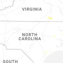
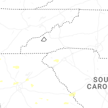
North Carolina
| Local Time | Report Details |
|---|---|
| 5:12 PM EDT | Trees down on the 5400 block of highway 118 in grifto in craven county NC, 81.1 miles ESE of Raleigh, NC |
| 5:18 PM EDT | Trees down on s. main street and white ave in cove cit in craven county NC, 74.3 miles NNE of Wilmington, NC |
| 5:18 PM EDT | Trees down on willis road in cove cit in craven county NC, 74 miles NNE of Wilmington, NC |
| 5:19 PM EDT | Pecan tree down alongside a building in cove city. report relayed via faceboo in craven county NC, 74.3 miles NNE of Wilmington, NC |
| 5:33 PM EDT | Trees down... large pine tree branches snapped off in the are in beaufort county NC, 88.8 miles E of Raleigh, NC |
| 5:33 PM EDT | Trees down on hyman roa in craven county NC, 77.8 miles NNE of Wilmington, NC |
| 5:41 PM EDT | Door blown out at walmart in new bern. report relayed via faceboo in craven county NC, 77 miles NE of Wilmington, NC |
| 5:45 PM EDT | Limbs down on transformers in bridgeton sparking fire and smoke. report relayed via faceboo in craven county NC, 80.6 miles NE of Wilmington, NC |
| 5:51 PM EDT | Tree down along the east bound lane near the intersection of i-40 and i-44 in wake county NC, 5.2 miles WSW of Raleigh, NC |
| 5:51 PM EDT | Power outage caused by fallen trees on equipment near wilmot drive and meredith s in wake county NC, 4.9 miles W of Raleigh, NC |
| 5:52 PM EDT | Emergency management reported a tree down at the intersection of croomsbridge rd and hwy 11 in pender county NC, 28 miles N of Wilmington, NC |
| 5:53 PM EDT | 51 kt gust observed in james cit in craven county NC, 78.6 miles NE of Wilmington, NC |
| 5:53 PM EDT | Tree down along broad creek road near fairfield harbo in craven county NC, 81.8 miles NE of Wilmington, NC |
| 5:04 AM EDT | Weather flow sensor reported a 55 kt wind gus in amz156 county NC, 101.8 miles ENE of Wilmington, NC |
| 5:38 AM EDT | Weather flow sensor reported a 50 kt wind gus in amz135 county NC, 110.7 miles S of Virginia Beach, VA |
South Dakota
| Local Time | Report Details |
|---|---|
| 4:40 PM CDT | Mesonet station 313 5se selby (sddot in walworth county SD, 71.6 miles W of Aberdeen, SD |
| 4:58 PM CDT | Mesonet station 216 bowdle (sddot in edmunds county SD, 56 miles W of Aberdeen, SD |
| 5:00 PM CDT | Personal weather station boulder farms - ksdhosme in mcpherson county SD, 47.9 miles WNW of Aberdeen, SD |
| 6:00 PM CDT | Some shingles torn of in faulk county SD, 26 miles SW of Aberdeen, SD |
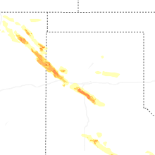
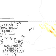
New Mexico
| Local Time | Report Details |
|---|---|
| 4:32 PM MDT | Ping Pong Ball sized hail reported near Grenville, NM, 91.2 miles N of Tucumcari, NM, a storm chaser shared video of estimated ping-pong ball size hail. |
| 5:51 PM MDT | Half Dollar sized hail reported near Amistad, NM, 63.9 miles NNE of Tucumcari, NM, report from mping: half dollar (1.25 in.). |
| 5:55 PM MDT | Golf Ball sized hail reported near Clayton, NM, 72.2 miles NNE of Tucumcari, NM, report of golf ball sized hail near sedan. |
| 5:55 PM MDT | Golf Ball sized hail reported near Amistad, NM, 63.6 miles NNE of Tucumcari, NM, report from mping: golf ball (1.75 in.). |
| 6:16 PM MDT | Golf Ball sized hail reported near Sedan, NM, 68.8 miles NNE of Tucumcari, NM, report from mping: golf ball (1.75 in.). |
| 6:18 PM MDT | Ping Pong Ball sized hail reported near Sedan, NM, 70.1 miles NNE of Tucumcari, NM, report from mping: ping pong ball (1.50 in.). |
| 6:40 PM MDT | Golf Ball sized hail reported near Grenville, NM, 77.3 miles N of Tucumcari, NM, golf ball sized hail reported at pasamonte ranch. |
| 7:20 PM MDT | Hen Egg sized hail reported near Clayton, NM, 62.8 miles NNE of Tucumcari, NM, report from mping: hen egg (2.00 in.). |
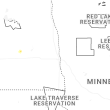
North Dakota
| Local Time | Report Details |
|---|---|
| 5:45 PM CDT | Mesonet station 324209 hillsboro nd ndaw in traill county ND, 33.4 miles N of Fargo, ND |
South Carolina
| Local Time | Report Details |
|---|---|
| 7:11 PM EDT | Social media report of several trees down in the fair play are in oconee county SC, 31.3 miles SW of Greenville, SC |
| 7:14 PM EDT | Several trees down along highway 11 between westminster and i-8 in oconee county SC, 30.9 miles SW of Greenville, SC |
| 7:17 PM EDT | Several trees downed at springfield campgroun in anderson county SC, 29.7 miles SSW of Greenville, SC |
| 7:19 PM EDT | Multiple trees and large limbs down in the west union are in oconee county SC, 25.5 miles W of Greenville, SC |
| 7:20 PM EDT | Multiple trees down in senec in oconee county SC, 22.4 miles WSW of Greenville, SC |
| 7:21 PM EDT | Trees down on the southern end of lake keowe in oconee county SC, 18.7 miles WSW of Greenville, SC |
| 7:24 PM EDT | Trees and powerlines down in the salem are in oconee county SC, 22 miles W of Greenville, SC |
| 7:26 PM EDT | Storm damage reported in laurens county SC, 55.9 miles ESE of Greenville, SC |
| 7:26 PM EDT | Storm damage reported in pickens county SC, 16.3 miles SW of Greenville, SC |
| 7:26 PM EDT | Storm damage reported in anderson county SC, 24.3 miles SSW of Greenville, SC |
| 7:26 PM EDT | Trees and powerlines down in the iva are in anderson county SC, 36.1 miles S of Greenville, SC |
| 7:29 PM EDT | Several trees downed at shores of asbury rv par in anderson county SC, 22.5 miles SSW of Greenville, SC |
| 7:30 PM EDT | Trees and powerlines downed in the lowndesville are in abbeville county SC, 42.9 miles S of Greenville, SC |
| 7:30 PM EDT | Numerous large limbs downed in the centerville are in anderson county SC, 21.5 miles SSW of Greenville, SC |
| 7:30 PM EDT | Tree down in la franc in anderson county SC, 18 miles SSW of Greenville, SC |
| 7:35 PM EDT | Several trees down along hwy 81 between i-85 and anderso in anderson county SC, 15.2 miles S of Greenville, SC |
| 7:36 PM EDT | Trees and powerlines down in libert in pickens county SC, 5.8 miles WSW of Greenville, SC |
| 7:39 PM EDT | Several trees down in the antreville are in abbeville county SC, 36.8 miles S of Greenville, SC |
| 7:41 PM EDT | Mccormick county dispatch reported trees down throughout the county. time estimated by rada in mccormick county SC, 48.3 miles NW of Augusta, GA |
| 7:42 PM EDT | Tree down on powerline in belto in anderson county SC, 22.2 miles SSE of Greenville, SC |
| 7:46 PM EDT | Several trees down in honea pat in anderson county SC, 28.9 miles SSE of Greenville, SC |
| 7:46 PM EDT | Tree down across brushy creek r in pickens county SC, 2.7 miles SE of Greenville, SC |
| 7:50 PM EDT | Several social media reports of trees downed in the abbeville are in abbeville county SC, 46.6 miles SSE of Greenville, SC |
| 7:50 PM EDT | Several trees down around pelzer... including at least one on powerline in anderson county SC, 15.4 miles SSE of Greenville, SC |
| 7:50 PM EDT | Multiple tress down around powdersvill in anderson county SC, 6.9 miles ESE of Greenville, SC |
| 7:50 PM EDT | Mccormick county dispatch reported trees down throughout the county. time estimated by rada in mccormick county SC, 35.1 miles NNW of Augusta, GA |
| 7:51 PM EDT | Several trees downed in the piedmont are in anderson county SC, 12.1 miles SE of Greenville, SC |
| 7:55 PM EDT | Tree down on powerline in bere in greenville county SC, 9 miles ENE of Greenville, SC |
| 7:56 PM EDT | Fallen trees or limbs on powerline in greenville county SC, 7.9 miles ENE of Greenville, SC |
| 7:59 PM EDT | Mccormick county dispatch reported trees down throughout the county. time estimated by rada in mccormick county SC, 34.5 miles NNW of Augusta, GA |
| 7:59 PM EDT | Tree down across bennett street near east park avenu in greenville county SC, 12.1 miles E of Greenville, SC |
| 8:00 PM EDT | Trees... large limbs and powerlines downed around the greenwood are in greenwood county SC, 50.2 miles SSE of Greenville, SC |
| 8:00 PM EDT | Multiple trees and tree limbs down on roa in oconee county SC, 17.7 miles W of Greenville, SC |
| 8:06 PM EDT | Trees and powerlines down in the lake greenwood are in greenwood county SC, 50.7 miles SE of Greenville, SC |
| 8:07 PM EDT | Edgefield county dispatch reported trees down along red hill rd. time estimated by rada in edgefield county SC, 21.1 miles NNW of Augusta, GA |
| 8:08 PM EDT | Several trees downed in the ninety six are in greenwood county SC, 47.7 miles N of Augusta, GA |
| 8:10 PM EDT | Edgefield county dispatch reports trees down along hwy 378 in edgefield county. time estimated by rada in edgefield county SC, 31.2 miles N of Augusta, GA |
| 8:10 PM EDT | Edgefield county dispatch reported trees down along republican rd. time estimated by rada in edgefield county SC, 12.8 miles NNW of Augusta, GA |
| 8:15 PM EDT | Multiple trees and limbs down on multiple roads including highway 7 in laurens county SC, 39.4 miles ESE of Greenville, SC |
| 8:16 PM EDT | Sc highway patrol reported trees down at the intersection of sc 39 and sc 34. time estimated by rada in newberry county SC, 48.7 miles N of Augusta, GA |
| 8:22 PM EDT | Public reports widespread trees and powerlines down across saluda county. time estimated based on rada in saluda county SC, 37.8 miles NNE of Augusta, GA |
| 8:25 PM EDT | Edgefield county dispatch reported trees down along hwy 25 north. time estimated by rada in edgefield county SC, 14.3 miles NNE of Augusta, GA |
| 8:25 PM EDT | Multiple trees down in joann in laurens county SC, 53.6 miles ESE of Greenville, SC |
| 8:29 PM EDT | Aiken county em office reports trees down at the intersection of hammond dr and woodlawn avenue. time estimated by rada in aiken county SC, 2.1 miles N of Augusta, GA |
| 8:32 PM EDT | Public reports widespread tree and powerline damage throughout newberry county. time estimated by rada in newberry county SC, 58.9 miles NNE of Augusta, GA |
| 8:34 PM EDT | Aiken county em reported numerous trees and powerlines in the clearwater are of aiken county. time estimated by rada in aiken county SC, 5.1 miles ENE of Augusta, GA |
| 8:34 PM EDT | Sc highway patrol reports a tree down along i20. time estimated by rada in newberry county SC, 62.7 miles ESE of Greenville, SC |
| 8:35 PM EDT | Multiple trees and powerlines dow in spartanburg county SC, 33.2 miles ESE of Greenville, SC |
| 8:36 PM EDT | Trees dow in spartanburg county SC, 39 miles ESE of Greenville, SC |
| 8:36 PM EDT | Sc highway patrol reports a tree down along i20. time estimated by rada in newberry county SC, 62.3 miles NNE of Augusta, GA |
| 8:36 PM EDT | Sc highway patrol reports a tree down at the intersection of us 378 and spann rd. time estimated by rada in saluda county SC, 44.6 miles NNE of Augusta, GA |
| 8:39 PM EDT | Aiken county em reported numerous trees and powerlines in the graniteville area of aiken county. time estimated by rada in aiken county SC, 11.1 miles ENE of Augusta, GA |
| 8:40 PM EDT | Multiple trees and powerlines dow in spartanburg county SC, 39.2 miles ENE of Greenville, SC |
| 8:45 PM EDT | Multiple trees down on powerline in cherokee county SC, 49.3 miles ENE of Greenville, SC |
| 8:47 PM EDT | Sc highway patrol reports a tree down at the intersection of amicks ferry rd and lake tide dr. time estimated by rada in lexington county SC, 57 miles NE of Augusta, GA |
| 8:50 PM EDT | Aiken county em office reported a tree down at the intersection of nazarene rd and wire rd. time estimated by rada in aiken county SC, 35.2 miles NE of Augusta, GA |
| 8:50 PM EDT | Multiple trees down on powerline in cherokee county SC, 46.9 miles W of Charlotte, NC |
| 8:51 PM EDT | Multiple trees down on powerline in cherokee county SC, 45.8 miles WSW of Charlotte, NC |
| 8:52 PM EDT | Sc highway patrol reports a tree down in the roadway along us 278 at sc 19. time estimated by rada in aiken county SC, 18.1 miles ESE of Augusta, GA |
| 8:53 PM EDT | Sc highway patrol reports a tree down along pet sites rd. time estimated by rada in richland county SC, 62.7 miles NE of Augusta, GA |
| 8:55 PM EDT | Trained spotter estimated wind gusts near 60 mph in the persimmon grove neighborhood in lexington. time estimated by rada in lexington county SC, 49.8 miles NE of Augusta, GA |
| 8:55 PM EDT | Multiple trees dow in spartanburg county SC, 48.6 miles E of Greenville, SC |
| 8:57 PM EDT | Sc highway patrol reports powerlines down blocking the roadway along north lake dr. time estimated by rada in lexington county SC, 59.6 miles NE of Augusta, GA |
| 8:57 PM EDT | Fairfield county dispatch reported numerous trees down throughout the county. time estimated by rada in fairfield county SC, 66.6 miles SSW of Charlotte, NC |
| 9:03 PM EDT | Sc highway patrol reports a tree down in the roadway at i20 and sunset blvd. time estimated by rada in lexington county SC, 60 miles NE of Augusta, GA |
| 9:06 PM EDT | Sc highway patrol reports a tree down in the roadway at romain dr and cambout st. time estimated by rada in richland county SC, 64.4 miles NE of Augusta, GA |
| 9:08 PM EDT | Video posted on social media of numerous trees down along i20 near the broad river bridge on the richland county side. trees were blocking the right two lanes of traffi in richland county SC, 65.3 miles NE of Augusta, GA |
| 9:11 PM EDT | Kcae recorded a peak wind gust of 60 mph at 9:11 p in lexington county SC, 59.1 miles ENE of Augusta, GA |
| 9:15 PM EDT | Sc highway patrol reports a tree down blocking the roadway on i77 and sc48. time estimated by rada in richland county SC, 65.4 miles ENE of Augusta, GA |
| 9:15 PM EDT | Orangeburg county em reported trees down at 1400 springfield rd. time estimated based on rada in orangeburg county SC, 39.6 miles E of Augusta, GA |
| 9:15 PM EDT | Barnwell dispatch reported numerous trees and power lines down across the count in barnwell county SC, 38.7 miles ESE of Augusta, GA |
| 9:17 PM EDT | Nws employee estimated wind gusts to 60 mph in blythewoo in richland county SC, 74.1 miles NE of Augusta, GA |
| 9:19 PM EDT | Sc highway patrol reported trees down in the road along running fox rd. time estimated by rada in richland county SC, 75.7 miles NE of Augusta, GA |
| 9:26 PM EDT | Orangeburg county em reported trees down at 5967 savannah highway. time estimated based on rada in orangeburg county SC, 49.6 miles E of Augusta, GA |
| 9:30 PM EDT | Social media report of large trees limbs snapped in hopkin in richland county SC, 69.5 miles ENE of Augusta, GA |
| 9:35 PM EDT | Orangeburg county em reported trees down at 7099 north rd. time estimated based on rada in orangeburg county SC, 55.9 miles E of Augusta, GA |
| 9:37 PM EDT | Orangeburg county em reports trees down at 299 beason rd. time estimated by rada in orangeburg county SC, 58.7 miles E of Augusta, GA |
| 9:37 PM EDT | Sc highway patrol reports trees blocking the roadway at the intersection of us 601 and mccord ferry rd. time estimated by rada in kershaw county SC, 74.1 miles NNW of Charleston, SC |
| 9:37 PM EDT | Orangeburg county em reported tree down at the intersection of sabb rd and shillings bridge rd. time estimated based on rada in orangeburg county SC, 56.4 miles E of Augusta, GA |
| 9:43 PM EDT | Bamberg county dispatch reported trees down on powerlines along heritage hwy in bamberg county. time estimated by rada in bamberg county SC, 52.6 miles W of Charleston, SC |
| 9:48 PM EDT | Orangeburg county em reported trees down in the town of rowesville. time estimated based on rada in orangeburg county SC, 49.4 miles WNW of Charleston, SC |
| 9:50 PM EDT | Orangeburg county em reports trees down at 3791 belleville road. time estimated by rada in orangeburg county SC, 51.5 miles WNW of Charleston, SC |
| 9:53 PM EDT | Sumter fire dept reported a tree on power lines at the intersection of hwy 261 and mine hill rd. time estimated by rada in sumter county SC, 57.8 miles NNW of Charleston, SC |
| 9:57 PM EDT | Orangeburg county em reported tree down along vance rd. time estimated based on rada in orangeburg county SC, 39.5 miles WNW of Charleston, SC |
| 10:06 PM EDT | Sumter fire reported a tree on power line at guignard pkwy and pocalla r in sumter county SC, 51 miles NNW of Charleston, SC |
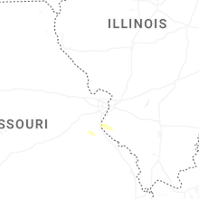
Missouri
| Local Time | Report Details |
|---|---|
| 7:10 PM CDT | Minor damage to homes reported. possible tornado damage... survey will be planne in jefferson county MO, 43 miles SW of Saint Louis, MO |
| 7:14 PM CDT | Quarter sized hail reported near De Soto, MO, 41.2 miles SSW of Saint Louis, MO |
| 10:30 PM CDT | Tree reported down on power lines and on fire just near fruitland. residential gas leak reported just west of fruitland. times estimated via rada in cape girardeau county MO, 8.6 miles NNW of Cape Girardeau, MO |
| 10:31 PM CDT | Significant tree damage near the intersection of hwy y and hwy w. multiple trees down across roadways and powerline in cape girardeau county MO, 8.6 miles NNW of Cape Girardeau, MO |
Texas
| Local Time | Report Details |
|---|---|
| 9:19 PM CDT | Tennis Ball sized hail reported near Dalhart, TX, 53.6 miles NE of Tucumcari, NM, report from mping: tennis ball (2.50 in.). |
| 9:21 PM CDT | Hen Egg sized hail reported near Dalhart, TX, 55.7 miles NE of Tucumcari, NM, report from mping: hen egg+ (2.25 in.). |
| 12:26 AM CDT | Quarter sized hail reported near Sherman, TX, 54.6 miles NNE of Dallas, TX, emergency management reported light coverage of hail up to quarter-size one mile north of tom bean. |
| 2:25 AM CDT | Mesonet station 76 umbarger 3nn in randall county TX, 20.5 miles SW of Amarillo, TX |
| 2:29 AM CDT | Ping Pong Ball sized hail reported near Amarillo, TX, 13.5 miles SW of Amarillo, TX, mping report of ping pong ball hail. |
| 2:30 AM CDT | West texas mesone in randall county TX, 16.8 miles SSW of Amarillo, TX |
| 2:35 AM CDT | Numerous reports of broken windows... broken tree limbs up to 4 inches in diameter... and wind/hail damage across the city of canyo in randall county TX, 16.4 miles SSW of Amarillo, TX |
| 2:40 AM CDT | Hen Egg sized hail reported near Canyon, TX, 16.1 miles SSW of Amarillo, TX |
| 3:01 AM CDT | Storm damage reported in castro county TX, 56.5 miles SSW of Amarillo, TX |
| 5:48 AM CDT | Golf Ball sized hail reported near Lorenzo, TX, 19.5 miles ENE of Lubbock, TX, report from mping: golf ball (1.75 in.). |
| 5:50 AM CDT | Golf Ball sized hail reported near Lorenzo, TX, 19.5 miles ENE of Lubbock, TX |
| 6:17 AM CDT | West texas mesone in crosby county TX, 39.8 miles E of Lubbock, TX |
Virginia
| Local Time | Report Details |
|---|---|
| 6:10 AM EDT | Quarter sized hail reported near Jarratt, VA, 51.6 miles S of Richmond, VA, estimated quarter size hail from vdot camera at mm17 on i-95 north. |
| 7:05 AM EDT | The 911 call center reported a tree leaning on a power line on linden street in courtland. time estimated from rada in southampton county VA, 55.6 miles W of Virginia Beach, VA |
| 7:11 AM EDT | The 911 call center reported large tree limbs down on governor darden road. time estimated from rada in southampton county VA, 55 miles W of Virginia Beach, VA |
Connect with Interactive Hail Maps