

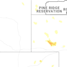
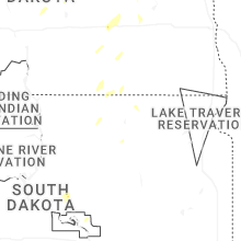
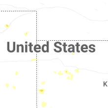
Hail Map for Friday, July 4, 2025
Number of Impacted Households on 7/4/2025
0
Impacted by 1" or Larger Hail
0
Impacted by 1.75" or Larger Hail
0
Impacted by 2.5" or Larger Hail
Square Miles of Populated Area Impacted on 7/4/2025
0
Impacted by 1" or Larger Hail
0
Impacted by 1.75" or Larger Hail
0
Impacted by 2.5" or Larger Hail
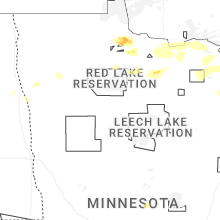
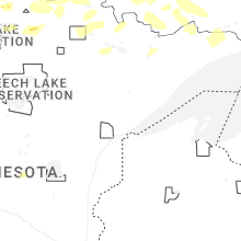
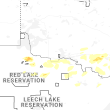
Cities Most Affected by Hail Storms of 7/4/2025
| Hail Size | Demographics of Zip Codes Affected | ||||||
|---|---|---|---|---|---|---|---|
| City | Count | Average | Largest | Pop Density | House Value | Income | Age |
| Baudette, MN | 1 | 2.75 | 2.75 | 5 | $74k | $34.4k | 48.8 |
Hail and Wind Damage Spotted on 7/4/2025
Filter by Report Type:Hail ReportsWind Reports
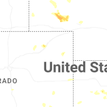
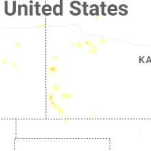
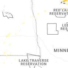
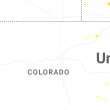
States Impacted
Minnesota, Colorado, North Dakota, South Dakota, Tennessee, Alabama, Georgia, Wyoming, Idaho, South Carolina, Utah, Kansas, OregonMinnesota
| Local Time | Report Details |
|---|---|
| 12:55 PM CDT | Baseball sized hail reported near Baudette, MN, 56.2 miles ESE of Roseau, MN, facebook report of baseball sized hail. time estimated. |
| 1:00 PM CDT | Trees and a power line down... location and time estimated from report/radar. also unknown size of hail at time of repor in lake of the woods county MN, 53.1 miles W of International Falls, MN |
| 2:59 PM CDT | Corrects previous non thunderstorm wind gust report from 1 s international falls to a thunderstorm wind gust. asos station kinl international falls airpor in koochiching county MN, 2.3 miles S of International Falls, MN |
| 3:51 PM CDT | A few small trees were down with some small debris being picked up by the winds as wel in st. louis county MN, 28.9 miles SE of International Falls, MN |
| 7:45 PM CDT | There were reports of damage around potato lake with docks and boats missing. time estimated via rada in hubbard county MN, 32.2 miles SSW of Bemidji, MN |
| 7:56 PM CDT | There were reports of several aspens down (8 inches - 10 inches in width). time estimated via rada in hubbard county MN, 28 miles S of Bemidji, MN |
Colorado
| Local Time | Report Details |
|---|---|
| 12:24 PM MDT | Quarter sized hail reported near U S A F Academy, CO, 51.8 miles S of Denver, CO |
| 1:10 PM MDT | Storm damage reported in el paso county CO, 43.2 miles NNE of Pueblo, CO |
| 5:43 PM MDT | Weatherlink station wl-cope3.32 in washington county CO, 33.2 miles SSW of Yuma, CO |
| 6:00 PM MDT | Storm damage reported in yuma county CO, 26.6 miles NE of Yuma, CO |
| 6:20 PM MDT | Time estimate in washington county CO, 31.7 miles SSW of Yuma, CO |
North Dakota
| Local Time | Report Details |
|---|---|
| 2:52 PM CDT | Quarter sized hail reported near Jamestown, ND, 78.4 miles S of Devils Lake, ND, ham radio operator report of quarter sized hail at parkhurst. |
| 2:56 PM CDT | Asos station kjms jamestown airpor in stutsman county ND, 82.1 miles S of Devils Lake, ND |
| 3:06 PM CDT | Ndawn 10 meter peak wind repor in stutsman county ND, 82.7 miles W of Fargo, ND |
| 3:32 PM CDT | Storm damage reported in barnes county ND, 58.8 miles W of Fargo, ND |
| 4:26 PM CDT | Storm damage reported in cass county ND, 38.3 miles NW of Fargo, ND |
| 5:11 PM CDT | Photos of tree damage (limbs ~ 5-6 inches in width) and fence damage were reported. time estimated via rada in grand forks county ND, 66.6 miles N of Fargo, ND |
| 5:13 PM CDT | Delayed report: there was a report of tree branches down... trampoline thrown about 150 yards... and wind gust of 59 mph recorded. time estimated via rada in grand forks county ND, 69.6 miles N of Fargo, ND |
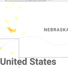
South Dakota
| Local Time | Report Details |
|---|---|
| 3:30 PM CDT | Asos station kabr aberdeen rgnl a in brown county SD, 3.3 miles E of Aberdeen, SD |
| 9:15 PM MDT | Storm damage reported in fall river county SD, 50.5 miles SSW of Rapid City, SD |
Tennessee
| Local Time | Report Details |
|---|---|
| 4:35 PM EDT | Several trees dow in polk county TN, 42.5 miles E of Chattanooga, TN |
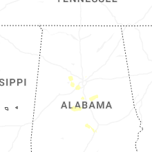
Alabama
| Local Time | Report Details |
|---|---|
| 3:35 PM CDT | Reports of trees down across southern shelby county. time estimated from rada in shelby county AL, 31.3 miles SSE of Birmingham, AL |
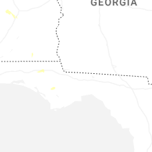
Georgia
| Local Time | Report Details |
|---|---|
| 4:55 PM EDT | Several trees snapped or toppled on the 2000 block of skeenah gap r in fannin county GA, 67.4 miles ESE of Chattanooga, TN |
Wyoming
| Local Time | Report Details |
|---|---|
| 3:27 PM MDT | Storm damage reported in fremont county WY, 22.7 miles SW of Riverton, WY |
| 3:30 PM MDT | Pavilion... wy cwop sit in fremont county WY, 23.7 miles NW of Riverton, WY |
| 3:40 PM MDT | At nws riverton wfo... measured gust from onsite weather statio in fremont county WY, 6.3 miles WNW of Riverton, WY |
| 4:21 PM MDT | Asos station kgey greybull airpor in big horn county WY, 89.7 miles SSE of Billings, MT |
| 4:40 PM MDT | 5 inch diameter tree branch fell on house... report from trained spotter. location approximat in washakie county WY, 72 miles NNE of Riverton, WY |
| 4:47 PM MDT | Wy dot weather senso in natrona county WY, 52.9 miles WNW of Casper, WY |
| 5:00 PM MDT | Mesonet station pc457 hidden dom in washakie county WY, 76.7 miles NNE of Riverton, WY |
| 5:12 PM MDT | Wy dot weather statio in natrona county WY, 27 miles WNW of Casper, WY |
| 5:20 PM MDT | Mesonet station rsnw4 hiland 16 s... time estimate... fales roc in natrona county WY, 47.8 miles W of Casper, WY |
| 5:42 PM MDT | Wy dot weather senso in natrona county WY, 27 miles WNW of Casper, WY |
| 5:42 PM MDT | Wy dot weather senso in natrona county WY, 1.5 miles NNW of Casper, WY |
| 5:50 PM MDT | Mesonet station pc576 horse ranch cree in natrona county WY, 22.8 miles N of Casper, WY |
| 5:50 PM MDT | Casper mountain road... wy pacificorp sit in natrona county WY, 5.5 miles S of Casper, WY |
| 5:50 PM MDT | Scenic drive... wy pacificorp sit in natrona county WY, 4.2 miles SSE of Casper, WY |
| 5:50 PM MDT | Claude creek... wy pacificorp sit in natrona county WY, 6.8 miles SE of Casper, WY |
| 5:52 PM MDT | Mesonet station wy61 i25 - hat si in natrona county WY, 6.5 miles E of Casper, WY |
| 6:20 PM MDT | Mesonet station pc602 glen rock rolling hill in converse county WY, 27.4 miles ENE of Casper, WY |
| 6:50 PM MDT | Measured at the evanston uinta county airport burns field aso in uinta county WY, 57.5 miles NE of Salt Lake City, UT |
| 7:00 PM MDT | Measured at the first divide wyoming dot rwis sit in uinta county WY, 67.3 miles ENE of Salt Lake City, UT |
| 7:24 PM MDT | Corrects previous tstm wnd gst report from 8 ne bill to add staion information. umrb station dcmw4 (bill 8ne in converse county WY, 66.9 miles ENE of Casper, WY |
| 7:34 PM MDT | Storm damage reported in campbell county WY, 36.8 miles S of Gillette, WY |
| 8:06 PM MDT | Storm damage reported in weston county WY, 52.6 miles SE of Gillette, WY |
| 8:44 PM MDT | Storm damage reported in weston county WY, 58.7 miles WSW of Rapid City, SD |
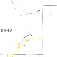
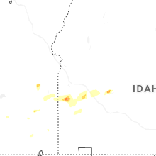
Idaho
| Local Time | Report Details |
|---|---|
| 4:00 PM MDT | Mesonet station fafi 3.1 sw fairfield (agrimet in camas county ID, 55.1 miles NNW of Twin Falls, ID |
| 4:00 PM MDT | Mesonet station sldmt 9.8 nw soldier (uunet in camas county ID, 65 miles E of Boise, ID |
| 4:17 PM MDT | Quarter sized hail reported near American Falls, ID, 69 miles E of Twin Falls, ID, estimated quarter size hail in the area of i-86 exit 21 osborn loop near and just east of cold water rest area. time estimated based on radar. |
| 4:42 PM MDT | Tree down in the skyline drive area of sun valley. time estimated via rada in blaine county ID, 78.5 miles N of Twin Falls, ID |
| 4:42 PM MDT | Tree down in the wyyakin drive area of sun valley. time estimated via rada in blaine county ID, 77.1 miles N of Twin Falls, ID |
| 4:42 PM MDT | Tree down in the adams gulch area just outside of ketchum. time estimated via rada in blaine county ID, 79.7 miles N of Twin Falls, ID |
South Carolina
| Local Time | Report Details |
|---|---|
| 6:48 PM EDT | Scdps website reported a tree in roadway at the intersection of church street and west hampton lane. time estimated by rada in sumter county SC, 53.5 miles NNW of Charleston, SC |
| 6:52 PM EDT | Sumter county 911 dispatch reported trees down throughout the county. no specifics give in sumter county SC, 62.3 miles NNW of Charleston, SC |
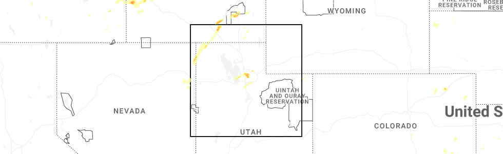
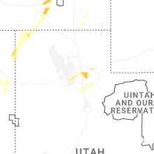
Utah
| Local Time | Report Details |
|---|---|
| 5:40 PM MDT | Report from social media of a downed tree in kaysville from thunderstorm winds. nearby mesonet stations reported gusts of 48 and 54 mp in davis county UT, 17.4 miles N of Salt Lake City, UT |
| 6:00 PM MDT | Quarter sized hail reported near Morgan, UT, 22.8 miles NNE of Salt Lake City, UT, photo received via social media. time estimated by radar. |
| 6:30 PM MDT | Stokes canyon pacificorp station gusted to 62 mp in morgan county UT, 38.3 miles NE of Salt Lake City, UT |
Kansas
| Local Time | Report Details |
|---|---|
| 6:00 PM MDT | Storm damage reported in hamilton county KS, 62.2 miles W of Garden City, KS |
| 8:40 PM CDT | Em reported downed 4 to 6 inch tree limb in grant county KS, 37.8 miles SW of Garden City, KS |
Oregon
| Local Time | Report Details |
|---|---|
| 7:24 PM MDT | Mesonet station gsfo3 grassy mountai in malheur county OR, 91 miles SW of Boise, ID |
Connect with Interactive Hail Maps