

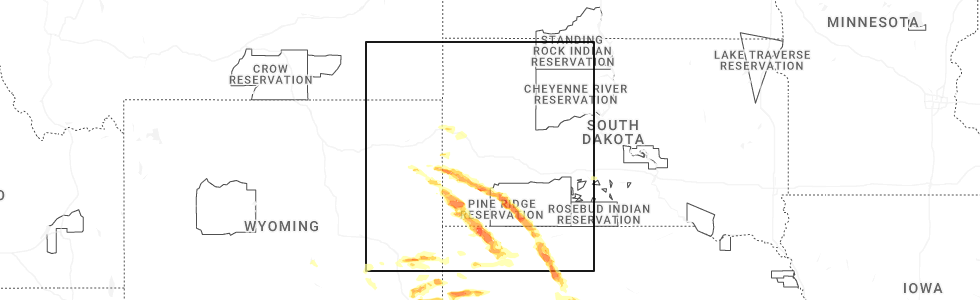
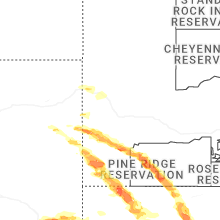
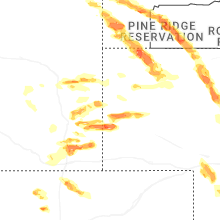
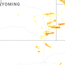
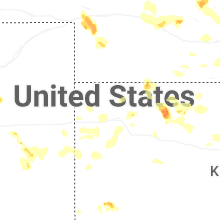
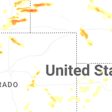
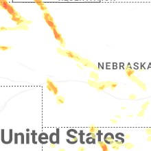
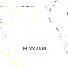
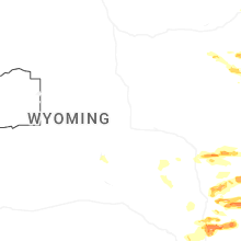
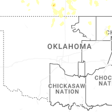
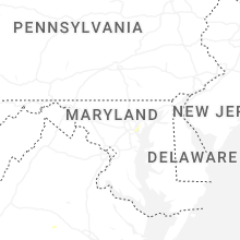
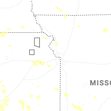
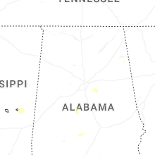
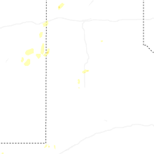
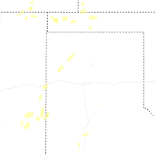
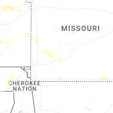
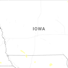
Hail Map for Sunday, June 29, 2025
Number of Impacted Households on 6/29/2025
0
Impacted by 1" or Larger Hail
0
Impacted by 1.75" or Larger Hail
0
Impacted by 2.5" or Larger Hail
Square Miles of Populated Area Impacted on 6/29/2025
0
Impacted by 1" or Larger Hail
0
Impacted by 1.75" or Larger Hail
0
Impacted by 2.5" or Larger Hail
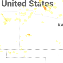

Cities Most Affected by Hail Storms of 6/29/2025
| Hail Size | Demographics of Zip Codes Affected | ||||||
|---|---|---|---|---|---|---|---|
| City | Count | Average | Largest | Pop Density | House Value | Income | Age |
| Lyman, NE | 3 | 2.02 | 2.30 | 3 | $29k | $27.0k | 40.9 |
| Scottsbluff, NE | 2 | 1.75 | 1.75 | 157 | $75k | $31.0k | 37.9 |
| Whitman, NE | 1 | 2.00 | 2.00 | 0 | $22k | $33.4k | 35.5 |
| Gordon, NE | 1 | 2.00 | 2.00 | 2 | $46k | $28.0k | 45.1 |
| Buffalo Gap, SD | 1 | 1.75 | 1.75 | 0 | $45k | $29.9k | 50.6 |
| Lingle, WY | 1 | 1.75 | 1.75 | 3 | $78k | $36.6k | 46.5 |
| Torrington, WY | 1 | 1.75 | 1.75 | 13 | $79k | $33.0k | 43.0 |
| Cheyenne, WY | 1 | 1.75 | 1.75 | 26 | $135k | $54.6k | 42.7 |
| Claremore, OK | 1 | 1.75 | 1.75 | 189 | $91k | $43.0k | 38.5 |
Hail and Wind Damage Spotted on 6/29/2025
Filter by Report Type:Hail ReportsWind Reports
States Impacted
South Dakota, Kansas, Alabama, Wisconsin, Missouri, Wyoming, Illinois, Colorado, Maryland, Georgia, Delaware, New Jersey, Arkansas, Nebraska, Texas, New Mexico, OklahomaSouth Dakota
| Local Time | Report Details |
|---|---|
| 6:35 AM MDT | Quarter sized hail reported near Custer, SD, 28.7 miles SW of Rapid City, SD, largest hail about the size of a quarter. most hail was smaller... pea to nickel |
| 6:35 AM MDT | Half Dollar sized hail reported near Custer, SD, 28.3 miles SSW of Rapid City, SD, photos show several stones of quarter to at least half dollar size |
| 2:52 PM MDT | Quarter sized hail reported near Custer, SD, 30.7 miles SW of Rapid City, SD, hail covered the ground. |
| 3:25 PM MDT | Quarter sized hail reported near Fairburn, SD, 27.6 miles SSW of Rapid City, SD |
| 4:40 PM MDT | Golf Ball sized hail reported near Buffalo Gap, SD, 56.2 miles SSE of Rapid City, SD |
| 5:00 PM MDT | Storm damage reported in fall river county SD, 56.1 miles SW of Rapid City, SD |
| 5:12 PM MDT | Quarter sized hail reported near Manderson, SD, 68.9 miles SSE of Rapid City, SD |
| 5:12 PM MDT | Storm damage reported in oglala lakota county SD, 68.9 miles SSE of Rapid City, SD |
| 5:22 PM MDT | Quarter sized hail reported near Edgemont, SD, 61.7 miles SSW of Rapid City, SD, nickel to quarter size hail. ongoing during call around 527 pm. |
| 5:25 PM MDT | Half Dollar sized hail reported near Edgemont, SD, 61.7 miles SSW of Rapid City, SD |
| 6:12 PM MDT | Storm damage reported in fall river county SD, 71 miles S of Rapid City, SD |
| 6:20 PM MDT | Quarter sized hail reported near Oelrichs, SD, 74.5 miles S of Rapid City, SD |
| 8:40 PM CDT | Mesonet station 315 cresbard (sddot in faulk county SD, 31.9 miles SW of Aberdeen, SD |
| 9:16 PM CDT | Mesonet station 175 mellette (sddot in spink county SD, 20.7 miles S of Aberdeen, SD |
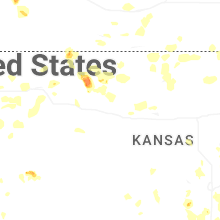
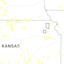
Kansas
| Local Time | Report Details |
|---|---|
| 10:50 AM CDT | Raws station qnrk1 staffor in stafford county KS, 68.4 miles SE of Hays, KS |
| 1:22 PM CDT | Multiple social media reports of limbs down in the linn valley area. time estimated from rada in linn county KS, 51 miles S of Kansas City, MO |
| 6:59 PM CDT | Half Dollar sized hail reported near Augusta, KS, 20 miles E of Wichita, KS |
| 7:23 PM CDT | Ping Pong Ball sized hail reported near Derby, KS, 11.8 miles SSE of Wichita, KS |
| 7:41 PM CDT | Storm damage reported in greenwood county KS, 42.8 miles W of Chanute, KS |
| 7:41 PM CDT | Storm damage reported in greenwood county KS, 42.8 miles W of Chanute, KS |
| 7:45 PM CDT | Delayed report. courtesy of ksu mesone in elk county KS, 46.8 miles ESE of Wichita, KS |
| 7:49 PM CDT | Half Dollar sized hail reported near Mulvane, KS, 15.2 miles SSE of Wichita, KS, courtesy of kwch. |
| 8:45 PM CDT | Report relayed by e in cowley county KS, 35.4 miles SSE of Wichita, KS |
| 8:52 PM CDT | Asos station kwld strother field airport. gusted to 60 mph at 8:54pm as wel in cowley county KS, 39.4 miles SSE of Wichita, KS |
| 8:55 PM CDT | Four-inch diameter limbs blown down... estimating at least 60 mp in chautauqua county KS, 54.2 miles SW of Chanute, KS |
| 8:58 PM CDT | Asos station kwld strother field airpor in cowley county KS, 39.4 miles SSE of Wichita, KS |
| 9:00 PM CDT | Storm damage reported in cowley county KS, 45.6 miles SSE of Wichita, KS |
| 9:01 PM CDT | Kwld measured 68 mp in cowley county KS, 39.2 miles SSE of Wichita, KS |
| 9:05 PM CDT | Asos station kwld strother field airpor in cowley county KS, 39.4 miles SSE of Wichita, KS |
| 10:51 PM CDT | Ping Pong Ball sized hail reported near Lakin, KS, 21.2 miles W of Garden City, KS, social media post. |
| 2:15 AM CDT | Half Dollar sized hail reported near Jennings, KS, 41.7 miles ENE of Colby, KS, relayed report. firefighter reported half dollar sized hail. |
| 2:55 AM CDT | Site khlc reports 59 mph wind gus in graham county KS, 43.9 miles NW of Hays, KS |
| 3:02 AM CDT | Site khlc reports 60 mph wind gus in graham county KS, 44.1 miles NW of Hays, KS |
| 3:13 AM CDT | Site six toes feed & seed reports 58 mph wind gus in sheridan county KS, 31.4 miles E of Colby, KS |
| 4:40 AM CDT | Storm damage reported in russell county KS, 28.2 miles E of Hays, KS |
| 4:46 AM CDT | Bunkerhill mesonet measured 72 mp in russell county KS, 36.3 miles E of Hays, KS |
Alabama
| Local Time | Report Details |
|---|---|
| 11:55 AM CDT | A tree was knocked down at 3609 garth road blocking the roadway completely. time estimated by rada in morgan county AL, 47.1 miles ESE of Florence, AL |
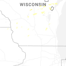
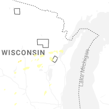
Wisconsin
| Local Time | Report Details |
|---|---|
| 1:00 PM CDT | Quarter sized hail reported near Wisconsin Rapids, WI, 82.8 miles ENE of La Crosse, WI, report via social media. |
| 1:09 PM CDT | Half Dollar sized hail reported near Wisconsin Rapids, WI, 84.5 miles ENE of La Crosse, WI, relayed via wsaw-tv. |
| 1:11 PM CDT | Several trees down. time estimated from rada in waupaca county WI, 56.5 miles W of Green Bay, WI |
| 1:27 PM CDT | Half Dollar sized hail reported near Wisconsin Rapids, WI, 83.7 miles W of Green Bay, WI, time estimated by radar. |
| 1:34 PM CDT | Corrects previous tstm wnd dmg report from scandinavia. several trees down. time estimated from rada in waupaca county WI, 56.5 miles W of Green Bay, WI |
| 1:42 PM CDT | Quarter sized hail reported near Iola, WI, 54.6 miles W of Green Bay, WI, estimated 50 to 60 mph wind gusts. |
| 1:48 PM CDT | Damaging wind gust snapped a large maple tree onto a she in waupaca county WI, 55.1 miles W of Green Bay, WI |
| 2:46 PM CDT | Uprooted tree. time estimated by rada in waupaca county WI, 45.3 miles W of Green Bay, WI |
| 3:18 PM CDT | Wind damage to power transformer causing the power to be knocked out. blown transformer seen on video via social medi in brown county WI, 8.3 miles NNW of Green Bay, WI |
| 3:20 PM CDT | Powerlines dow in brown county WI, 1 miles E of Green Bay, WI |
| 7:26 PM CDT | Tree down relayed from social media. time estimated from rada in milwaukee county WI, 68.2 miles E of Madison, WI |
| 7:26 PM CDT | Awos station kmwc milwaukee lawrence-timmerman airpor in milwaukee county WI, 68.7 miles E of Madison, WI |
| 8:44 PM CDT | Photo shared on social media of large tree trunk split near 106th and congress in northern wauwautos in milwaukee county WI, 68.2 miles E of Madison, WI |
| 8:49 PM CDT | Broadcast media relays report of tree down near 97th and carmen near butle in milwaukee county WI, 68.7 miles E of Madison, WI |
| 9:20 PM CDT | Off-duty nws employee reports large tree and branch down near silver spring drive and interstate 4 in milwaukee county WI, 67.2 miles E of Madison, WI |
| 9:23 PM CDT | Milwaukee fire department reports that an empty plane was flipped from thunderstorm wind gusts at milwaukee lawrence-timmerman airpor in milwaukee county WI, 68.7 miles E of Madison, WI |
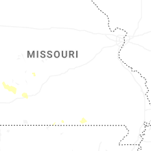
Missouri
| Local Time | Report Details |
|---|---|
| 1:22 PM CDT | Social media reports of downed wires and power outages near route aa. time estimated from rada in bates county MO, 44.6 miles S of Kansas City, MO |
| 1:25 PM CDT | Social media report of downed power poles and power lines on route 18 near county road 6001. time estimated from rada in bates county MO, 48.9 miles S of Kansas City, MO |
| 1:35 PM CDT | Social media report of downed wires near route f. time estimated from rada in bates county MO, 54.7 miles S of Kansas City, MO |
| 3:00 PM CDT | Multiple trees down and roads blocked in nevada... m in vernon county MO, 61.3 miles E of Chanute, KS |
| 3:51 PM CDT | Tree just took out powerline in yard... both dow in dade county MO, 38.4 miles WNW of Springfield, MO |
| 4:00 PM CDT | In greenfield... mo 6-8 inch to entire trees uprooted... a metal roof with 1/3 of roof gone. about from well street along 39 hwy south and back eas in dade county MO, 33.7 miles WNW of Springfield, MO |
| 4:20 PM CDT | 6-8 inch branches down in lawrence county halltown area. via fire de in lawrence county MO, 18.7 miles W of Springfield, MO |
| 4:30 PM CDT | Tree hanging over roadwa in christian county MO, 13.3 miles SSW of Springfield, MO |
| 4:30 PM CDT | Trees and power lines down across roads... tree down on house... tree down on car in ash grov in greene county MO, 17.6 miles WNW of Springfield, MO |
| 4:30 PM CDT | Major number of trees uprooted and neighbors old barn levele in greene county MO, 16.8 miles WNW of Springfield, MO |
| 4:34 PM CDT | Tree completely blocking roa in christian county MO, 14.6 miles SSE of Springfield, MO |
| 4:36 PM CDT | Large tree fell on power lin in christian county MO, 13.3 miles SSE of Springfield, MO |
| 4:36 PM CDT | Storm damage reported in greene county MO, 5.8 miles WNW of Springfield, MO |
| 4:36 PM CDT | Up to 16 inch diameter trees down mm 68 1/2 on i4 in greene county MO, 9.4 miles W of Springfield, MO |
| 4:39 PM CDT | Tree down blocking road blocking oak s in christian county MO, 13.8 miles SSE of Springfield, MO |
| 4:40 PM CDT | Tree down on powerlin in lawrence county MO, 39.7 miles WSW of Springfield, MO |
| 4:40 PM CDT | Two to three large trees dow in christian county MO, 14.7 miles SE of Springfield, MO |
| 4:42 PM CDT | 2 power poles snapped... and partially leaning into the roa in greene county MO, 5.5 miles SSW of Springfield, MO |
| 4:42 PM CDT | Whole intersection is blocked by a large tree in the roa in greene county MO, 5.2 miles SW of Springfield, MO |
| 4:42 PM CDT | Branches and power lines down. time based on rada in greene county MO, 2.7 miles WSW of Springfield, MO |
| 4:42 PM CDT | Line pole down on roadway. time based on radar estimat in barry county MO, 40 miles WSW of Springfield, MO |
| 4:42 PM CDT | Extensive tree damage on the north side of republic. estimated 40 percent of the city without power. time estimated from rada in greene county MO, 12.1 miles WSW of Springfield, MO |
| 4:42 PM CDT | Corrects time of previous tstm wnd dmg report from 1 sw republic. large branch fell on house. time based on radar estimate in greene county MO, 12.9 miles WSW of Springfield, MO |
| 4:43 PM CDT | Large tree down blocking both lanes of west battlefiel in greene county MO, 7.5 miles SW of Springfield, MO |
| 4:45 PM CDT | 24 inch tree dow in greene county MO, 8.1 miles SSW of Springfield, MO |
| 4:45 PM CDT | Large branch on hous in greene county MO, 2.2 miles SSW of Springfield, MO |
| 4:45 PM CDT | Tree on line in lawrence county MO, 43.3 miles WSW of Springfield, MO |
| 4:45 PM CDT | Tree branch fell on fence cause damag in greene county MO, 2.7 miles WSW of Springfield, MO |
| 4:45 PM CDT | Mocomagnet (university of missouri ag network) station near james river and interstate 4 in greene county MO, 8.3 miles W of Springfield, MO |
| 4:48 PM CDT | 10 inch limb on house. across the street there are two uprooted trees on pickup and garag in greene county MO, 6.1 miles SW of Springfield, MO |
| 4:50 PM CDT | 30 diameter elm tree completely uprooted. location: battlefield... mo near w weaver rd & ridgecrest d in greene county MO, 7.2 miles SSW of Springfield, MO |
| 4:53 PM CDT | Branches blown off... roof damage. time based on rada in greene county MO, 4.9 miles SSW of Springfield, MO |
| 4:53 PM CDT | Large tree broke near the base. older tree. time based on radar. shingles blown off of pawn shop off battlefield and kansa in greene county MO, 4 miles SSW of Springfield, MO |
| 4:54 PM CDT | Trees down on power lines. time based on radar estimat in greene county MO, 3.5 miles SE of Springfield, MO |
| 4:54 PM CDT | Trees dow in greene county MO, 3.3 miles SW of Springfield, MO |
| 4:54 PM CDT | 12 inch limbs dow in greene county MO, 6.5 miles SSW of Springfield, MO |
| 4:54 PM CDT | Large tree down on road blocking traffi in greene county MO, 4.8 miles S of Springfield, MO |
| 4:54 PM CDT | Tree blocking part of road on s sunrise in a couple of locations... traffic lights out in several locations along kansas expressway. power lines down on scenic... acros in greene county MO, 5.7 miles SW of Springfield, MO |
| 4:54 PM CDT | Tree across the road way blocking the roa in christian county MO, 11.8 miles SSW of Springfield, MO |
| 4:55 PM CDT | Power lines are down across the road... and a tree down. time based on radar estimat in greene county MO, 3.2 miles SSE of Springfield, MO |
| 4:55 PM CDT | 6 inch tree limbs down. time based on radar estimat in greene county MO, 2.9 miles SSE of Springfield, MO |
| 4:55 PM CDT | 1 mile south of cox south hospital has a significant sized tree limb on layfayette cour in greene county MO, 5.5 miles S of Springfield, MO |
| 4:56 PM CDT | Large tree blocking road. time based on rada in greene county MO, 3.4 miles S of Springfield, MO |
| 4:58 PM CDT | Large tree uprooted and large branches fell on house. via social media. time based on radar estimat in greene county MO, 1.7 miles SW of Springfield, MO |
| 4:59 PM CDT | Tree fell on mobile home no one is injure in christian county MO, 8.2 miles S of Springfield, MO |
| 5:00 PM CDT | Some trees down and partial road blockag in greene county MO, 3.9 miles SE of Springfield, MO |
| 5:00 PM CDT | Trees down at golf cours in greene county MO, 7.9 miles SSE of Springfield, MO |
| 5:00 PM CDT | Pictures of a fireworks tent blown ove in christian county MO, 11 miles S of Springfield, MO |
| 5:05 PM CDT | Lots of tree limbs down a few trees toppled... and power outages. anemometer and outdoor weather statio in christian county MO, 11.7 miles S of Springfield, MO |
| 5:06 PM CDT | Tree down across the roa in christian county MO, 19.1 miles SE of Springfield, MO |
| 5:15 PM CDT | 60-70 mph winds downed trees and power lines. four boats were capsized on table rock lak in stone county MO, 40.6 miles S of Springfield, MO |
| 5:18 PM CDT | Tree down on roa in christian county MO, 21.3 miles S of Springfield, MO |
| 5:24 PM CDT | 8 inch tree limb down. time based on rada in webster county MO, 28.8 miles E of Springfield, MO |
| 5:25 PM CDT | Mesonet station fw9611 branso in taney county MO, 35.3 miles S of Springfield, MO |
| 5:30 PM CDT | 6 to 8 inch tree branch broke off. time based on rada in barry county MO, 56.9 miles SW of Springfield, MO |
| 5:36 PM CDT | 8-10 in diameter tree top broke... and landed near a campe in barry county MO, 52.7 miles SSW of Springfield, MO |
| 5:37 PM CDT | *** 4 inj *** four injured by flying debris at the thunder ridge nature aren in taney county MO, 48.2 miles S of Springfield, MO |
| 5:42 PM CDT | Large branch fell on house. time based on radar estimate in greene county MO, 12.9 miles WSW of Springfield, MO |
Wyoming
| Local Time | Report Details |
|---|---|
| 2:00 PM MDT | Storm damage reported in weston county WY, 49.1 miles WSW of Rapid City, SD |
| 2:59 PM MDT | Quarter sized hail reported near Cheyenne, WY, 34.4 miles E of Laramie, WY |
| 3:08 PM MDT | Mesonet station wy22 2.7 nw arlington (wydot). gust was associated with decaying showers/storm in carbon county WY, 39.9 miles WNW of Laramie, WY |
| 3:20 PM MDT | Quarter sized hail reported near Cheyenne, WY, 39.6 miles E of Laramie, WY, report from mping: quarter (1.00 in.). |
| 3:21 PM MDT | Half Dollar sized hail reported near Cheyenne, WY, 39.6 miles E of Laramie, WY, report from mping: half dollar (1.25 in.). |
| 3:25 PM MDT | Ping Pong Ball sized hail reported near Cheyenne, WY, 39.6 miles E of Laramie, WY |
| 4:13 PM MDT | Quarter sized hail reported near Newcastle, WY, 57.6 miles WSW of Rapid City, SD |
| 4:25 PM MDT | Golf Ball sized hail reported near Cheyenne, WY, 49.2 miles SW of Scottsbluff, NE |
| 5:05 PM MDT | Half Dollar sized hail reported near Hawk Springs, WY, 32.6 miles WSW of Scottsbluff, NE, half dollar sized hail reported just south of the intersection of us85 and wy313. |
| 6:13 PM MDT | Quarter sized hail reported near Veteran, WY, 38.2 miles WNW of Scottsbluff, NE, road covered in quarter sized hail 3 inches deep. |
| 6:17 PM MDT | Golf Ball sized hail reported near Lingle, WY, 39.4 miles WNW of Scottsbluff, NE |
| 6:18 PM MDT | Half Dollar sized hail reported near Lingle, WY, 38.5 miles WNW of Scottsbluff, NE |
| 6:30 PM MDT | Estimated wind gus in goshen county WY, 30.3 miles WNW of Scottsbluff, NE |
| 6:31 PM MDT | Large trees uproote in goshen county WY, 35.1 miles WNW of Scottsbluff, NE |
| 6:58 PM MDT | Quarter sized hail reported near Torrington, WY, 56.2 miles NW of Scottsbluff, NE, emergency manager found hail of quarter sized still on the side of the highway 85 at mp 129 at 8:12pm. time of hail falling was estimated based on radar. |
| 7:11 PM MDT | Golf Ball sized hail reported near Torrington, WY, 50.2 miles NNW of Scottsbluff, NE |
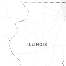
Illinois
| Local Time | Report Details |
|---|---|
| 3:16 PM CDT | Photos shared show corn blown down and a large tree limb blown dow in ford county IL, 63.9 miles E of Peoria, IL |
| 8:00 PM CDT | Measured gust to 51 knots at pw in cook county IL, 20.8 miles NW of Chicago, IL |
| 8:16 PM CDT | Weatherbug station measured wind gust to 64 mp in lake county IL, 21.5 miles NNW of Chicago, IL |
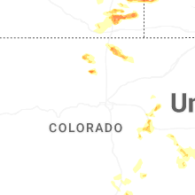
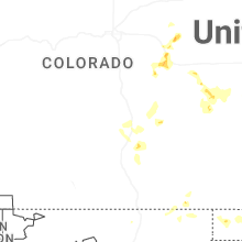
Colorado
| Local Time | Report Details |
|---|---|
| 3:00 PM MDT | Quarter sized hail reported near Bellvue, CO, 50.9 miles S of Laramie, WY |
| 3:30 PM MDT | Quarter sized hail reported near Nunn, CO, 58.7 miles SE of Laramie, WY |
| 4:25 PM MDT | Quarter sized hail reported near Lyons, CO, 42.8 miles NNW of Denver, CO |
| 7:56 PM MDT | Storm damage reported in lincoln county CO, 78.4 miles SSW of Yuma, CO |
| 8:08 PM MDT | Site up695 reports 58 mph wind gus in cheyenne county CO, 89.9 miles ENE of Pueblo, CO |
| 9:14 PM MDT | Site co068 reports 60 mph wind gus in cheyenne county CO, 89.7 miles WSW of Colby, KS |
| 9:20 PM MDT | Site up723 reports 59 mph wind gus in cheyenne county CO, 86.2 miles WSW of Colby, KS |
| 9:39 PM MDT | Site kemp well service reports 61 mph wind gus in cheyenne county CO, 80.2 miles WSW of Colby, KS |
| 9:52 PM MDT | Mesonet station up694 2.2 e arapahoe (upr) gusted to 59 mp in cheyenne county CO, 69.4 miles WSW of Colby, KS |
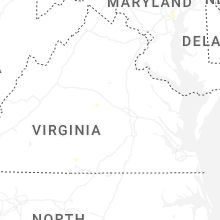
Maryland
| Local Time | Report Details |
|---|---|
| 5:21 PM EDT | There was a report of large tree limbs blown down near dundal in baltimore county MD, 5.7 miles ESE of Baltimore, MD |
| 5:25 PM EDT | Numerous trees and wires blew down in and around the dundalk are in baltimore county MD, 6 miles ESE of Baltimore, MD |
| 5:26 PM EDT | Quarter sized hail reported near Dundalk, MD, 5.7 miles ESE of Baltimore, MD, quarter size hail was reported near dundalk. |
| 5:30 PM EDT | Large tree limbs snapped in dundal in baltimore county MD, 6 miles ESE of Baltimore, MD |
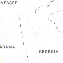
Georgia
| Local Time | Report Details |
|---|---|
| 5:40 PM EDT | Trees reported down across the road on hwy 52 e near the intersection with roy r in gilmer county GA, 59.3 miles ESE of Chattanooga, TN |
Delaware
| Local Time | Report Details |
|---|---|
| 6:14 PM EDT | Corrects previous tstm wnd gst report from bethel. measured wind gust of 58 mph with tree limbs down and a portion of metal roofing was peeled off a house nearby in bet in sussex county DE, 33.3 miles WNW of Ocean City, MD |
| 6:29 PM EDT | Multiple tree branches snapped on holly branch drive and road 492 in sussex county DE, 32.9 miles WNW of Ocean City, MD |
| 6:29 PM EDT | Large tree split and snapped along woodland ferry road right next to the laurel little league fields. time estimated from rada in sussex county DE, 31.4 miles WNW of Ocean City, MD |
New Jersey
| Local Time | Report Details |
|---|---|
| 6:50 PM EDT | Atlantic city international airport asos station measured a 60 mph wind gust at 6:50 p in atlantic county NJ, 81.8 miles NNE of Ocean City, MD |
Arkansas
| Local Time | Report Details |
|---|---|
| 6:20 PM CDT | Tree down on vaughn road in sw part of centerton blocking the roadway. exact location estimated. time estimated via rada in benton county AR, 66.9 miles N of Fort Smith, AR |
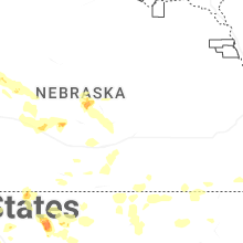
Nebraska
| Local Time | Report Details |
|---|---|
| 5:31 PM MDT | Ping Pong Ball sized hail reported near Lyman, NE, 21 miles WSW of Scottsbluff, NE |
| 5:35 PM MDT | Golf Ball sized hail reported near Lyman, NE, 19.6 miles WSW of Scottsbluff, NE |
| 5:35 PM MDT | Hen Egg sized hail reported near Lyman, NE, 18.3 miles WSW of Scottsbluff, NE, measured 2 inch hail at the intersection of county road x and county road 6. |
| 5:49 PM MDT | Hen Egg sized hail reported near Lyman, NE, 15.3 miles WSW of Scottsbluff, NE |
| 6:10 PM MDT | Quarter sized hail reported near Mitchell, NE, 9.2 miles W of Scottsbluff, NE |
| 6:18 PM MDT | Half Dollar sized hail reported near Mitchell, NE, 7.7 miles W of Scottsbluff, NE |
| 6:27 PM MDT | At least 10 large trees blown over at the scottsbluff country club. several homes had broken windows due to wind driven hai in scotts bluff county NE, 3.4 miles NNW of Scottsbluff, NE |
| 6:27 PM MDT | 8 inch tree trunk snappe in scotts bluff county NE, 3.3 miles N of Scottsbluff, NE |
| 6:30 PM MDT | Hen Egg sized hail reported near Gordon, NE, 74.2 miles W of Valentine, NE, report via social media. |
| 6:33 PM MDT | Golf Ball sized hail reported near Scottsbluff, NE, 0.6 miles NNE of Scottsbluff, NE |
| 6:33 PM MDT | Quarter sized hail reported near Scottsbluff, NE, 1.4 miles NNE of Scottsbluff, NE, report from mping: quarter (1.00 in.). |
| 6:35 PM MDT | Golf Ball sized hail reported near Scottsbluff, NE, 0.6 miles NNE of Scottsbluff, NE, estimated 70 mph winds. some trees blown over. |
| 6:36 PM MDT | Quarter sized hail reported near Scottsbluff, NE, 5.4 miles N of Scottsbluff, NE, report from mping: quarter (1.00 in.). |
| 6:44 PM MDT | Ping Pong Ball sized hail reported near Chadron, NE, 72.8 miles NNE of Scottsbluff, NE |
| 6:44 PM MDT | Ping Pong Ball sized hail reported near Mitchell, NE, 5 miles W of Scottsbluff, NE |
| 6:50 PM MDT | Asos station kcdr chadron airport - cd in dawes county NE, 72.8 miles NNE of Scottsbluff, NE |
| 6:52 PM MDT | Quarter sized hail reported near Minatare, NE, 11.2 miles ENE of Scottsbluff, NE, pea to quarter sized hail on the north side of lake minatare. time estimated via radar. |
| 7:12 PM MDT | Storm damage reported in dawes county NE, 63.3 miles NNE of Scottsbluff, NE |
| 8:15 PM MDT | Hen Egg sized hail reported near Whitman, NE, 70.3 miles SW of Valentine, NE, report via social media. time estimated from radar. |
| 11:15 PM MDT | Storm damage reported in perkins county NE, 53.3 miles WSW of North Platte, NE |
| 12:40 AM CDT | Also reported hail up to 1 inch diamete in lincoln county NE, 21.9 miles NE of North Platte, NE |
| 12:40 AM CDT | Quarter sized hail reported near Stapleton, NE, 21.9 miles NE of North Platte, NE |
| 11:53 PM MDT | Storm damage reported in chase county NE, 62.6 miles SW of North Platte, NE |
| 1:30 AM CDT | Storm damage reported in custer county NE, 38.6 miles E of North Platte, NE |
| 1:44 AM CDT | Quarter sized hail reported near Willow Island, NE, 40.3 miles ESE of North Platte, NE, quarter size hail. |
| 2:00 AM CDT | Unofficial personal weather statio in dawson county NE, 52.2 miles ESE of North Platte, NE |
| 2:15 AM CDT | Storm damage reported in dawson county NE, 57.2 miles ESE of North Platte, NE |
| 2:30 AM CDT | Unofficial personal weather statio in dawson county NE, 62.9 miles E of North Platte, NE |
| 2:44 AM CDT | Unofficial personal weather statio in buffalo county NE, 56.3 miles WSW of Grand Island, NE |
| 2:47 AM CDT | Unofficial personal weather statio in buffalo county NE, 52.1 miles WSW of Grand Island, NE |
| 2:51 AM CDT | Unofficial personal weather statio in buffalo county NE, 47.5 miles WSW of Grand Island, NE |
| 2:58 AM CDT | Unofficial personal weather statio in kearney county NE, 49.3 miles WSW of Grand Island, NE |
| 3:15 AM CDT | On the backside of storm in phelps county NE, 61.9 miles WSW of Grand Island, NE |
| 3:16 AM CDT | Storm damage reported in buffalo county NE, 41.5 miles WSW of Grand Island, NE |
| 3:18 AM CDT | Unofficial personal weather statio in kearney county NE, 46.6 miles SW of Grand Island, NE |
Texas
| Local Time | Report Details |
|---|---|
| 7:07 PM CDT | Reports of downed powerlines along highway 6 in terry county TX, 24.6 miles SW of Lubbock, TX |
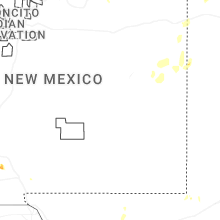
New Mexico
| Local Time | Report Details |
|---|---|
| 6:20 PM MDT | Mesonet station wsm51 malon in otero county NM, 81.8 miles NNE of El Paso, TX |
| 6:37 PM MDT | Awos station khmn holloman afb awo in otero county NM, 78.8 miles NNE of El Paso, TX |
| 6:40 PM MDT | Mesonet station wsm07 wsmr frequenc in otero county NM, 75.7 miles NNE of El Paso, TX |
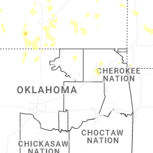
Oklahoma
| Local Time | Report Details |
|---|---|
| 7:53 PM CDT | Golf Ball sized hail reported near Claremore, OK, 31.1 miles NE of Tulsa, OK, pic of golf ball hail next to a ruler relayed via social media. |
| 9:30 PM CDT | Oklahoma mesonet newkirk statio in kay county OK, 59.1 miles SSE of Wichita, KS |
| 10:35 PM CDT | Corrects previous tstm wnd gst report from 3 sw skede in pawnee county OK, 44.5 miles WNW of Tulsa, OK |
| 12:15 AM CDT | Storm damage reported in major county OK, 70.8 miles NNW of Oklahoma City, OK |
| 12:21 AM CDT | Storm damage reported in garfield county OK, 64.4 miles NNW of Oklahoma City, OK |
| 12:30 AM CDT | 3 inch tree limbs down... reported from mpin in garfield county OK, 63.6 miles NNW of Oklahoma City, OK |
| 12:30 AM CDT | Delayed report of several power lines down. time estimated from rada in garfield county OK, 59.6 miles NNW of Oklahoma City, OK |
Connect with Interactive Hail Maps