

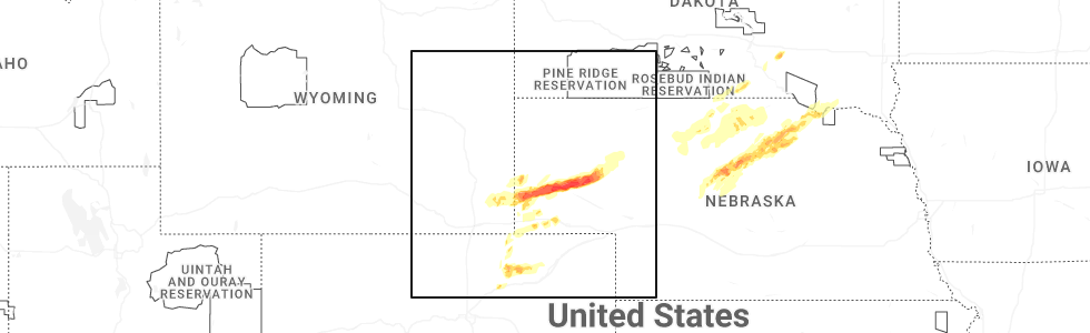
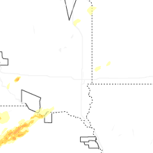
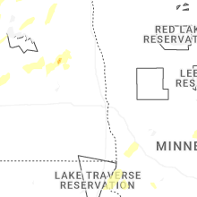
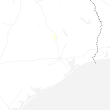
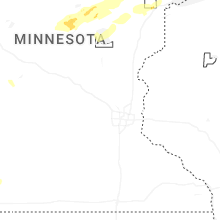
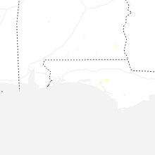
Hail Map for Sunday, June 22, 2025
Number of Impacted Households on 6/22/2025
0
Impacted by 1" or Larger Hail
0
Impacted by 1.75" or Larger Hail
0
Impacted by 2.5" or Larger Hail
Square Miles of Populated Area Impacted on 6/22/2025
0
Impacted by 1" or Larger Hail
0
Impacted by 1.75" or Larger Hail
0
Impacted by 2.5" or Larger Hail

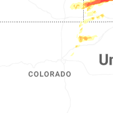
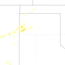
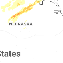
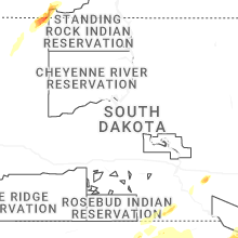
Cities Most Affected by Hail Storms of 6/22/2025
| Hail Size | Demographics of Zip Codes Affected | ||||||
|---|---|---|---|---|---|---|---|
| City | Count | Average | Largest | Pop Density | House Value | Income | Age |
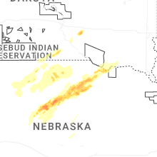
| Harrisburg, NE | 3 | 1.83 | 2.00 | 1 | $46k | $30.4k | 46.3 |
| Bayard, NE | 1 | 3.00 | 3.00 | 5 | $52k | $30.8k | 43.5 |
| Bridgeport, NE | 1 | 2.25 | 2.25 | 2 | $50k | $30.3k | 42.9 |
| Taylor, NE | 1 | 2.00 | 2.00 | 1 | $20k | $26.7k | 46.6 |
| Gering, NE | 1 | 1.75 | 1.75 | 52 | $75k | $34.5k | 38.2 |
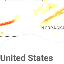
| Lemmon, SD | 1 | 1.75 | 1.75 | 2 | $85k | $28.6k | 50.7 |
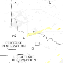
Hail and Wind Damage Spotted on 6/22/2025
Filter by Report Type:Hail ReportsWind Reports
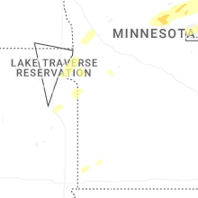
States Impacted
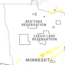
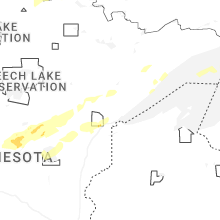
Minnesota, North Dakota, South Dakota, Georgia, Alabama, New Mexico, Nebraska, Texas, OklahomaMinnesota
| Local Time | Report Details |
|---|---|
| 8:15 AM CDT | Measured gust at fergus falls airpor in otter tail county MN, 51.3 miles SE of Fargo, ND |
| 8:15 AM CDT | Tree damage relayed by broadcast medi in otter tail county MN, 53.6 miles SE of Fargo, ND |
| 8:15 AM CDT | Delayed repot: photos of tree damage in fergus falls. time estimated via rada in otter tail county MN, 53.1 miles SE of Fargo, ND |
| 9:00 AM CDT | Tree damage relayed via broadcast medi in otter tail county MN, 59.7 miles ESE of Fargo, ND |
| 10:29 AM CDT | Personal wx station measuremen in marshall county MN, 66 miles WSW of Roseau, MN |
| 7:02 PM CDT | Storm damage reported in marshall county MN, 35.6 miles S of Roseau, MN |
| 2:30 AM CDT | County dispatch reported multiple trees and powerlines reported down in the city of aitkin. time estimated based on rada in aitkin county MN, 78.6 miles WSW of Duluth, MN |
| 2:39 AM CDT | County dispatch reported multiple trees and powerlines were down in the community of palisade. time estimated based on rada in aitkin county MN, 66.2 miles W of Duluth, MN |
| 2:45 AM CDT | Waukenabo mndot statio in aitkin county MN, 71.3 miles W of Duluth, MN |
| 2:48 AM CDT | County dispatch reported multiple trees down in and just north of the city of mcgregor. time estimated based on rada in aitkin county MN, 58.8 miles WSW of Duluth, MN |
| 3:05 AM CDT | Tamarack mndot statio in aitkin county MN, 47.7 miles WSW of Duluth, MN |
| 3:25 AM CDT | Quarter sized hail reported near Cloquet, MN, 24 miles WSW of Duluth, MN, facebook report with photo comparing to coin. estimated size based on the photo. time estimated based on radar. |
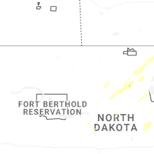
North Dakota
| Local Time | Report Details |
|---|---|
| 8:40 AM CDT | Quarter sized hail reported near Binford, ND, 44.9 miles SSE of Devils Lake, ND |
| 9:13 AM CDT | Quarter sized hail reported near Aneta, ND, 50.2 miles SE of Devils Lake, ND |
| 9:40 AM CDT | Tree branches dow in grand forks county ND, 65 miles NNW of Fargo, ND |
| 3:55 PM CDT | Quarter sized hail reported near Hannah, ND, 61.1 miles N of Devils Lake, ND, delayed report: hail 1 mile n of hannah. time estimated via radar. |
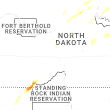
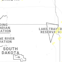
South Dakota
| Local Time | Report Details |
|---|---|
| 7:48 AM MDT | Golf Ball sized hail reported near Lemmon, SD, 88.9 miles SW of Bismarck, ND |
| 7:54 AM MDT | Quarter sized hail reported near Lemmon, SD, 85.9 miles SW of Bismarck, ND, reports thumb size hail. |
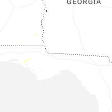
Georgia
| Local Time | Report Details |
|---|---|
| 2:31 PM EDT | Courtesy of uga steam mill mesonet sit in seminole county GA, 53.6 miles NW of Tallahassee, FL |
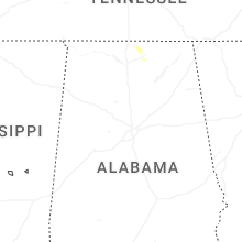
Alabama
| Local Time | Report Details |
|---|---|
| 2:06 PM CDT | Tree down along cr 115. time estimated by rada in jackson county AL, 53.9 miles SW of Chattanooga, TN |
| 3:10 PM CDT | Geneva county dispatch reports a tree down on county road 65 near 5 point in geneva county AL, 59.6 miles NNE of Miramar Beach, FL |
| 3:47 PM CDT | Dale county dispatch reports a tree down on county road 61 near county road 51 in dale county AL, 83.9 miles S of Auburn, AL |
| 4:47 PM CDT | Large trees downed and uprooted near looney road in athens. report and photos from social medi in limestone county AL, 42.6 miles E of Florence, AL |
| 4:56 PM CDT | Multiple trees down near county road 316 in trinity. report and photos from social media. time estimated from rada in morgan county AL, 36.3 miles ESE of Florence, AL |
| 4:58 PM CDT | Tree down blocking a couple lanes of traffic at moores mill road and highway 7 in madison county AL, 64.6 miles E of Florence, AL |
| 5:13 PM CDT | Downed large tree limbs caused damage to a house on jeff road. time estimated from rada in madison county AL, 54.9 miles E of Florence, AL |
| 5:36 PM CDT | Multiple trees down and power lines down in the 3200 area on county road 31 in lawrence county AL, 35 miles ESE of Florence, AL |
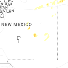
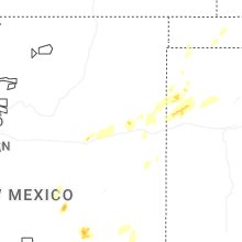
New Mexico
| Local Time | Report Details |
|---|---|
| 3:39 PM MDT | Cotton roa in chaves county NM, 6.1 miles WNW of Roswell, NM |
| 3:39 PM MDT | Apache hill in chaves county NM, 5.4 miles NW of Roswell, NM |
| 3:55 PM MDT | Mesonet station newn5 newkir in guadalupe county NM, 31.8 miles WSW of Tucumcari, NM |
| 4:25 PM MDT | Lots of dust kicked u in quay county NM, 19.3 miles W of Tucumcari, NM |
| 4:58 PM MDT | Utility poles blown down with arcing powerlines and electric service disrupted for resident in chaves county NM, 1.9 miles E of Roswell, NM |
| 5:08 PM MDT | Quarter sized hail reported near Roswell, NM, 4.4 miles NNW of Roswell, NM, lasted until 520 pm or so. |
| 5:32 PM MDT | Utility poles blown down with arcing powerlines and electric service disrupted for resident in chaves county NM, 1.8 miles NNW of Roswell, NM |
| 5:36 PM MDT | Storm damage reported in quay county NM, 41.2 miles NE of Tucumcari, NM |
| 5:42 PM MDT | Storm damage reported in quay county NM, 23 miles ESE of Tucumcari, NM |
| 5:53 PM MDT | Mesonet station 107 endee 2 s in quay county NM, 34.6 miles E of Tucumcari, NM |
| 6:17 PM MDT | Asos station krow roswell air cente in chaves county NM, 6.7 miles SSE of Roswell, NM |
| 7:40 PM MDT | Mesonet station tr724 roswell no. 1 portabl in chaves county NM, 35.6 miles ENE of Roswell, NM |
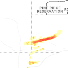
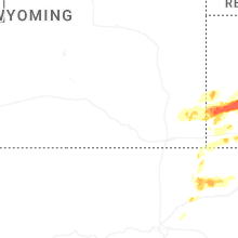
Nebraska
| Local Time | Report Details |
|---|---|
| 5:25 PM CDT | Half Dollar sized hail reported near Dunning, NE, 59 miles NE of North Platte, NE, 1.25 inches of precip in 40 minutes... quarter and half dollar size hail... wind gusts between 35 and 45 mph. |
| 4:38 PM MDT | Golf Ball sized hail reported near Harrisburg, NE, 22.8 miles SSW of Scottsbluff, NE, video nw of harrisburg. |
| 4:41 PM MDT | Golf Ball sized hail reported near Harrisburg, NE, 21.9 miles S of Scottsbluff, NE |
| 4:42 PM MDT | Golf Ball sized hail reported near Gering, NE, 20.4 miles S of Scottsbluff, NE, photos sent in slack of home with windows broken... accumulated hail in yard... large branches down. time estimated from radar. |
| 4:44 PM MDT | Hen Egg sized hail reported near Harrisburg, NE, 21.1 miles S of Scottsbluff, NE |
| 5:05 PM MDT | Ping Pong Ball sized hail reported near Harrisburg, NE, 22.3 miles SSE of Scottsbluff, NE, estimated wind gusts 60 to 70 mph. |
| 6:18 PM CDT | Half Dollar sized hail reported near Bassett, NE, 51.5 miles WSW of Oneill, NE, report from icechip. |
| 5:19 PM MDT | Tea Cup sized hail reported near Bayard, NE, 21.4 miles ESE of Scottsbluff, NE |
| 6:25 PM CDT | Hen Egg sized hail reported near Taylor, NE, 51.6 miles WSW of Oneill, NE, report from icechip. |
| 5:30 PM MDT | Hen Egg sized hail reported near Bridgeport, NE, 31.7 miles ESE of Scottsbluff, NE |
| 5:30 PM MDT | Estimated 60 to 70 mph wind in morrill county NE, 32.9 miles ESE of Scottsbluff, NE |
| 5:43 PM MDT | Tower1 upr (up417) reported gus in morrill county NE, 38.8 miles ESE of Scottsbluff, NE |
| 6:55 PM CDT | Photos of a snapped power pole and tree damag in holt county NE, 17.3 miles WSW of Oneill, NE |
| 6:17 PM MDT | Resn1 raws. time estimated by rada in garden county NE, 63.5 miles E of Scottsbluff, NE |
| 7:28 PM CDT | Konl awo in holt county NE, 2.3 miles WNW of Oneill, NE |
Texas
| Local Time | Report Details |
|---|---|
| 5:55 PM CDT | Sheriff department reports tree down on fm road 2087. also... the east texas regional airport in longview (kggg) asos reported a 56 mph wind gust around the same tim in gregg county TX, 60.4 miles W of Shreveport, LA |
| 6:49 PM CDT | Peak downburst wind gust of 59 mp in oldham county TX, 50.9 miles ENE of Tucumcari, NM |
| 7:21 PM CDT | Peak downburst wind gust of 60 mph with 2 gusts of 58 mph shortly afte in hartley county TX, 69.2 miles NW of Amarillo, TX |
| 7:53 PM CDT | Storm damage reported in oldham county TX, 52.5 miles W of Amarillo, TX |
| 8:00 PM CDT | Spotter reported dime size hail and 60 mph gusts 2 miles south of channing on hwy 38 in hartley county TX, 42.3 miles NW of Amarillo, TX |
| 8:10 PM CDT | The first gust of 59mph occurred at 810pm cdt... with another 58mph gust at 812pm cdt and the last 59mph gust at 814pm cd in oldham county TX, 33.2 miles NW of Amarillo, TX |
| 8:37 PM CDT | Storm damage reported in moore county TX, 43.2 miles N of Amarillo, TX |
| 8:51 PM CDT | Storm damage reported in potter county TX, 15.6 miles NNW of Amarillo, TX |
Oklahoma
| Local Time | Report Details |
|---|---|
| 9:30 PM CDT | Storm damage reported in texas county OK, 87.9 miles SW of Garden City, KS |
Connect with Interactive Hail Maps