

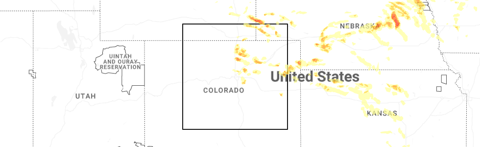
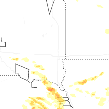
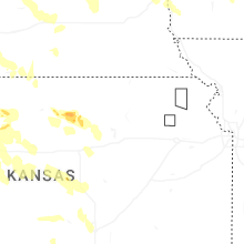
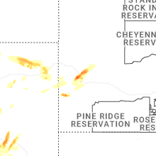
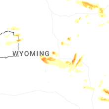
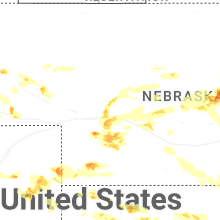
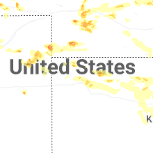
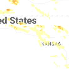
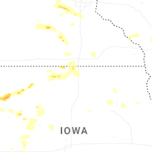
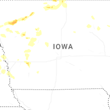
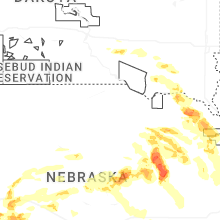
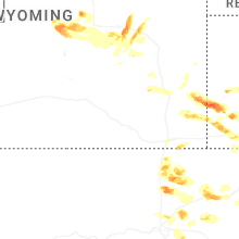
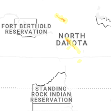
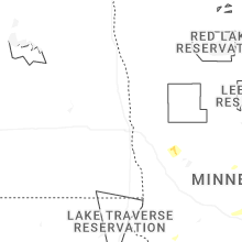
Hail Map for Monday, June 16, 2025
Number of Impacted Households on 6/16/2025
0
Impacted by 1" or Larger Hail
0
Impacted by 1.75" or Larger Hail
0
Impacted by 2.5" or Larger Hail
Square Miles of Populated Area Impacted on 6/16/2025
0
Impacted by 1" or Larger Hail
0
Impacted by 1.75" or Larger Hail
0
Impacted by 2.5" or Larger Hail


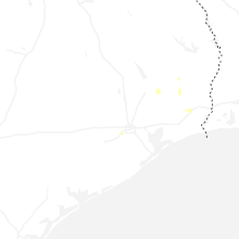
Cities Most Affected by Hail Storms of 6/16/2025
| Hail Size | Demographics of Zip Codes Affected | ||||||
|---|---|---|---|---|---|---|---|
| City | Count | Average | Largest | Pop Density | House Value | Income | Age |
| Waconia, MN | 2 | 2.63 | 3.25 | 404 | $157k | $59.4k | 35.9 |
| Wellington, CO | 2 | 2.25 | 2.50 | 33 | $136k | $52.2k | 33.1 |
| Casper, WY | 2 | 2.00 | 2.00 | 14 | $85k | $40.7k | 38.5 |
| Mankato, MN | 2 | 1.88 | 2.00 | 379 | $103k | $36.8k | 27.0 |
| Wellfleet, NE | 1 | 2.50 | 2.50 | 1 | $85k | $37.1k | 45.3 |
| Milliken, CO | 1 | 2.00 | 2.00 | 180 | $132k | $42.6k | 31.3 |
| Sutherland, NE | 1 | 1.75 | 1.75 | 3 | $74k | $38.9k | 40.6 |
| Lyman, NE | 1 | 1.75 | 1.75 | 3 | $29k | $27.0k | 40.9 |
| Meriden, WY | 1 | 1.75 | 1.75 | 1 | $113k | $29.0k | 46.0 |
| Tyndall, SD | 1 | 1.75 | 1.75 | 8 | $49k | $31.1k | 47.6 |
| Scottsbluff, NE | 1 | 1.75 | 1.75 | 157 | $75k | $31.0k | 37.9 |
| Genoa, NE | 1 | 1.75 | 1.75 | 5 | $52k | $32.4k | 41.5 |
| Arvada, WY | 1 | 1.75 | 1.75 | 0 | $23k | $46.1k | 45.0 |
| Glenrock, WY | 1 | 1.75 | 1.75 | 1 | $80k | $39.5k | 41.1 |
| Gillette, WY | 1 | 1.75 | 1.75 | 17 | $94k | $42.4k | 32.2 |
| Ranchester, WY | 1 | 1.75 | 1.75 | 1 | $92k | $38.4k | 36.1 |
| Cokato, MN | 1 | 1.75 | 1.75 | 50 | $110k | $45.3k | 32.4 |
| Eaton, CO | 1 | 1.75 | 1.75 | 71 | $146k | $43.6k | 38.4 |
Hail and Wind Damage Spotted on 6/16/2025
Filter by Report Type:Hail ReportsWind Reports
States Impacted
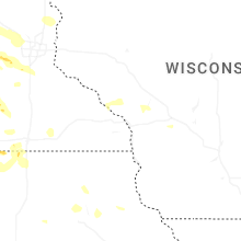
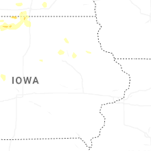
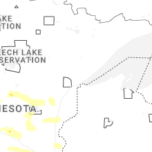
Minnesota, Iowa, Kansas, South Dakota, North Carolina, Mississippi, Indiana, Virginia, Nebraska, Montana, Alabama, Wyoming, North Dakota, Colorado, OklahomaMinnesota
| Local Time | Report Details |
|---|---|
| 7:10 AM CDT | Quarter sized hail reported near Pelican Rapids, MN, 41.6 miles ESE of Fargo, ND, at crystal lake. |
| 12:02 PM CDT | Photos of tree down causing structural damage to mndot facility. one photo showed a garage bay door blown inward. time estimated via rada in stearns county MN, 62 miles NW of Minneapolis, MN |
| 12:54 PM CDT | Photo of large tree down in residential are in stearns county MN, 63.9 miles NW of Minneapolis, MN |
| 12:57 PM CDT | Photo submitted of large pine tree down in southern waite park. time estimated via rada in stearns county MN, 61 miles NW of Minneapolis, MN |
| 12:57 PM CDT | Photo of large tree limbs down blocking trailway. time estimated via rada in stearns county MN, 61.8 miles NW of Minneapolis, MN |
| 12:57 PM CDT | Photo submitted of large trees down. time estimated via rada in stearns county MN, 63.1 miles NW of Minneapolis, MN |
| 1:02 PM CDT | Photo submitted tree limb down in residential area. time estimated via rada in stearns county MN, 60.4 miles NW of Minneapolis, MN |
| 2:32 PM CDT | Delayed lsr - tree damage photos provided near the intersection of bass lake rd and vicksburg ln in maple grove. time estimated via rada in hennepin county MN, 12.6 miles WNW of Minneapolis, MN |
| 4:40 PM CDT | Half Dollar sized hail reported near Nisswa, MN, 71.1 miles SSE of Bemidji, MN, photo was received showing larger than quarter-sized hail. |
| 4:42 PM CDT | Quarter sized hail reported near Nisswa, MN, 70.8 miles SSE of Bemidji, MN |
| 4:50 PM CDT | Several pictures received of downed trees that appeared to be a combination of snapped and uprooted...a business sign...and fence damage due to strong thunderstorm wind in crow wing county MN, 77 miles SSE of Bemidji, MN |
| 4:58 PM CDT | Trees fallen in multiple directions at the location. time estimated from rada in crow wing county MN, 76.4 miles SSE of Bemidji, MN |
| 5:25 PM CDT | Quarter sized hail reported near Dassel, MN, 50.4 miles W of Minneapolis, MN, multiple reports of quarter sized hail south of dassel. |
| 5:44 PM CDT | Quarter sized hail reported near Cokato, MN, 45.8 miles W of Minneapolis, MN |
| 5:46 PM CDT | Golf Ball sized hail reported near Cokato, MN, 43.3 miles W of Minneapolis, MN |
| 6:17 PM CDT | Around an 8 inch diameter pine tree down. multiple other branches down. time estimated by rada in st. louis county MN, 59.3 miles NW of Duluth, MN |
| 6:44 PM CDT | Half Dollar sized hail reported near Waconia, MN, 27.3 miles WSW of Minneapolis, MN, nws employee reported half dollar sized hail in waconia. |
| 7:01 PM CDT | Tea Cup sized hail reported near Waconia, MN, 28.7 miles WSW of Minneapolis, MN, photo measurement provided via slack. time estimated via radar. |
| 7:08 PM CDT | Ping Pong Ball sized hail reported near Victoria, MN, 20.9 miles WSW of Minneapolis, MN, report of a lot of hail up to ping pong size in victoria. |
| 7:10 PM CDT | Hen Egg sized hail reported near Waconia, MN, 28.4 miles WSW of Minneapolis, MN |
| 7:29 PM CDT | Quarter sized hail reported near Carver, MN, 23.4 miles SW of Minneapolis, MN |
| 7:40 PM CDT | Hen Egg sized hail reported near Mankato, MN, 65 miles SSW of Minneapolis, MN, tweeted report with photo measurement. |
| 7:44 PM CDT | Quarter sized hail reported near Mankato, MN, 64.5 miles SSW of Minneapolis, MN |
| 7:45 PM CDT | Quarter sized hail reported near Prior Lake, MN, 20.1 miles SSW of Minneapolis, MN, picture via x of quarter sized hail in prior lake. |
| 7:50 PM CDT | Ping Pong Ball sized hail reported near Mankato, MN, 65.9 miles SSW of Minneapolis, MN |
| 8:15 PM CDT | Golf Ball sized hail reported near Mankato, MN, 68.7 miles SSW of Minneapolis, MN |
Iowa
| Local Time | Report Details |
|---|---|
| 10:00 AM CDT | Quarter sized hail reported near Bancroft, IA, 51.4 miles WNW of Mason City, IA, relayed through ema social media. |
| 4:48 PM CDT | Power lines and several trees down near the intersection of k22 and c6 in plymouth county IA, 59.6 miles W of Storm Lake, IA |
| 5:10 PM CDT | Lots of branches knocked down in yard and house roof. speed estimated at 70 mph... due to moderate size of branche in woodbury county IA, 44 miles W of Storm Lake, IA |
| 5:25 PM CDT | Multiple trees down in pierso in woodbury county IA, 34.8 miles W of Storm Lake, IA |
| 5:33 PM CDT | Storm damage reported in woodbury county IA, 35.5 miles WSW of Storm Lake, IA |
| 5:34 PM CDT | Personal weather statio in cherokee county IA, 26.8 miles W of Storm Lake, IA |
| 5:37 PM CDT | Personal weather statio in cherokee county IA, 24.2 miles WNW of Storm Lake, IA |
| 5:46 PM CDT | Several large limbs dow in cherokee county IA, 19.6 miles WNW of Storm Lake, IA |
| 5:47 PM CDT | Corrects previous tstm wnd gst report from 1 s cherokee. awos station kckp cherokee municipal airpor in cherokee county IA, 18.6 miles WNW of Storm Lake, IA |
| 5:48 PM CDT | Roof peeled off a building. power outages throughout tow in cherokee county IA, 18.6 miles WNW of Storm Lake, IA |
| 6:14 PM CDT | Personal weather statio in clay county IA, 23 miles NNE of Storm Lake, IA |
| 7:09 PM CDT | Personal weather station gusted to 59 mph as the gust front moved throug in webster county IA, 47.2 miles ESE of Storm Lake, IA |
| 7:51 PM CDT | Personal weather station gusted to 60 mp in carroll county IA, 59 miles WNW of Des Moines, IA |
| 9:03 PM CDT | Personal weather station measured gust of 62 mp in mills county IA, 27.1 miles SE of Omaha, NE |
| 9:08 PM CDT | Strong wind gusts reported in atlantic... with medium to large sized tree branches down blocking multiple roads. pea-sized hail was observed at times... with heavy rain in cass county IA, 49.3 miles ENE of Omaha, NE |
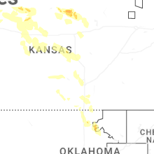
Kansas
| Local Time | Report Details |
|---|---|
| 12:40 PM CDT | Up846 reported the gus in gove county KS, 48.5 miles WNW of Hays, KS |
| 6:55 PM CDT | Quarter sized hail reported near Mc Donald, KS, 32.2 miles NNW of Colby, KS, nickel to quarter sized hail ongoing over a duration of 10 minutes. |
| 6:55 PM MDT | Reported via weatherunderground station kkskanor in sherman county KS, 48.1 miles W of Colby, KS |
| 8:21 PM CDT | Reported via ks mesonet cheyenne statio in cheyenne county KS, 43.9 miles WNW of Colby, KS |
| 8:40 PM CDT | Winds estimated and coming out of the southeas in rawlins county KS, 30.9 miles N of Colby, KS |
| 8:40 PM CDT | Estimated 70-80 mph winds off and o in rawlins county KS, 36.1 miles N of Colby, KS |
| 8:43 PM CDT | Awos station ksyf st. francis cit in cheyenne county KS, 47.8 miles WNW of Colby, KS |
| 8:53 PM CDT | Storm damage reported in cheyenne county KS, 39.2 miles NW of Colby, KS |
| 8:54 PM CDT | Spotter estimated 70 to 80 mph winds with blowing dust creating visibility reductions of 1/8 to 1/2 half mil in rawlins county KS, 30.9 miles N of Colby, KS |
| 8:55 PM CDT | Storm damage reported in cheyenne county KS, 27.4 miles NW of Colby, KS |
| 9:15 PM CDT | Awos station ksyf st. francis cit in cheyenne county KS, 47.8 miles WNW of Colby, KS |
| 9:15 PM CDT | Storm damage reported in rawlins county KS, 35.7 miles N of Colby, KS |
| 9:33 PM CDT | Report of brick car wash collapsing from wind in cheyenne county KS, 47.4 miles WNW of Colby, KS |
| 9:55 PM CDT | Awos station koin oberli in decatur county KS, 40.6 miles NE of Colby, KS |
| 9:56 PM CDT | Wl-norton 6.5 sse mesonet repor in norton county KS, 66.7 miles NNW of Hays, KS |
| 9:56 PM CDT | Storm damage reported in norton county KS, 66.7 miles NNW of Hays, KS |
| 10:15 PM CDT | Ksyf reported the wind gus in cheyenne county KS, 47.4 miles WNW of Colby, KS |
| 10:15 PM CDT | Awos station koin oberli in decatur county KS, 40.6 miles NE of Colby, KS |
| 10:16 PM CDT | Public report of 60 mph winds and blowing dust with visibility near in norton county KS, 62 miles NNW of Hays, KS |
| 10:21 PM CDT | Spotter reported multiple 8 inch green tree limbs blown roughly 300-350 feet to the north from the trees. also reported numerous 3-5 inch tree limbs on the ground as we in rawlins county KS, 30.9 miles N of Colby, KS |
| 10:34 PM CDT | Corrects previous tstm wnd gst report from 3 nw calvert. awn geil lodge gus in norton county KS, 73.3 miles NNW of Hays, KS |
| 10:38 PM CDT | Pws-kksnorca in decatur county KS, 54.5 miles ENE of Colby, KS |
| 11:40 PM CDT | Quarter sized hail reported near Stockton, KS, 39.4 miles N of Hays, KS, dispatch reports a few stones up to 1 inch diameter... most smaller. |
| 12:36 AM CDT | Mesonet station up846 2.0 e quinter (upr in gove county KS, 48.5 miles WNW of Hays, KS |
| 12:48 AM CDT | Ksu mesone in mitchell county KS, 71.9 miles ENE of Hays, KS |
| 12:50 AM CDT | Storm damage reported in mitchell county KS, 55.9 miles ENE of Hays, KS |
| 12:57 AM CDT | Storm damage reported in ellis county KS, 14.4 miles NNW of Hays, KS |
| 1:01 AM CDT | Storm damage reported in ellis county KS, 11.2 miles N of Hays, KS |
| 1:18 AM CDT | Ksu mesone in osborne county KS, 52.4 miles NE of Hays, KS |
| 1:22 AM CDT | Personal weather station. delayed repor in cloud county KS, 69.6 miles WNW of Manhattan, KS |
| 1:25 AM CDT | Asos station krsl russell municipal airpor in russell county KS, 27.6 miles E of Hays, KS |
| 1:25 AM CDT | Spotter also lost power with the strong wind in lincoln county KS, 64.7 miles E of Hays, KS |
| 1:34 AM CDT | Asos station krsl russell municipal airpor in russell county KS, 27.6 miles E of Hays, KS |
| 1:49 AM CDT | Personal weather statio in ottawa county KS, 71.3 miles W of Manhattan, KS |
| 2:05 AM CDT | Delayed repor in cloud county KS, 63.7 miles WNW of Manhattan, KS |
| 2:10 AM CDT | Storm damage reported in ottawa county KS, 53.2 miles W of Manhattan, KS |
| 2:12 AM CDT | Storm damage reported in barton county KS, 44.7 miles SSE of Hays, KS |
| 2:14 AM CDT | Personal weather statio in ottawa county KS, 55.8 miles W of Manhattan, KS |
| 2:14 AM CDT | Time estimated radar. 4 inch diameter tree limb over road. delayed repor in dickinson county KS, 28.1 miles WSW of Manhattan, KS |
| 2:21 AM CDT | Personal weather statio in ottawa county KS, 56 miles W of Manhattan, KS |
| 2:23 AM CDT | Report received from the kansas state mesone in pawnee county KS, 51.7 miles S of Hays, KS |
| 2:32 AM CDT | Mesonet station ur445 3.2 e new cambria (upr in saline county KS, 51.8 miles WSW of Manhattan, KS |
| 2:32 AM CDT | A 7-inch diameter dead tree branch broken off and on the ground. this report received from social medi in pawnee county KS, 49.3 miles SSE of Hays, KS |
| 2:34 AM CDT | Storm damage reported in saline county KS, 54 miles WSW of Manhattan, KS |
| 2:45 AM CDT | Via social media. delayed report. downed tree of unknown diameter. power is also ou in dickinson county KS, 46.5 miles WSW of Manhattan, KS |
| 2:55 AM CDT | Awos station klyo lyons rice co. municipal airp in rice county KS, 66.9 miles NW of Wichita, KS |
| 3:02 AM CDT | Report from kansas mesone in rice county KS, 62.7 miles NW of Wichita, KS |
| 3:03 AM CDT | Reports of trees down (unknown diameter) and power poles down throughout abilen in dickinson county KS, 39.7 miles WSW of Manhattan, KS |
| 3:30 AM CDT | Spotter estimated 70-80 mph wind gusts. very heavy rainfall as wel in mcpherson county KS, 45.8 miles NW of Wichita, KS |
| 3:31 AM CDT | Asos station khut hutchinson municipal airpor in reno county KS, 39.4 miles NW of Wichita, KS |
| 3:38 AM CDT | Wind gusts between 70 to 80 mph estimate in mcpherson county KS, 51.8 miles NNW of Wichita, KS |
| 3:53 AM CDT | Storm damage reported in sedgwick county KS, 21.8 miles NW of Wichita, KS |
| 3:54 AM CDT | At least 80 mph in the city of mount hop in sedgwick county KS, 21.8 miles NW of Wichita, KS |
| 3:55 AM CDT | Measured at the mcpherson airpor in mcpherson county KS, 49.6 miles NNW of Wichita, KS |
| 3:57 AM CDT | At least 70 mph estimate in mcpherson county KS, 38.1 miles NNW of Wichita, KS |
| 4:00 AM CDT | Large tree dow in harvey county KS, 23.6 miles NNW of Wichita, KS |
| 4:08 AM CDT | Large tree down at sw 96th and burmac roa in harvey county KS, 24.8 miles NW of Wichita, KS |
| 4:22 AM CDT | Reported at kic in sedgwick county KS, 5.8 miles WSW of Wichita, KS |
| 4:24 AM CDT | Mesonet station up317 0.8 w canton (upr in mcpherson county KS, 48.1 miles N of Wichita, KS |
| 4:34 AM CDT | Storm damage reported in sedgwick county KS, 7.7 miles NE of Wichita, KS |
| 4:35 AM CDT | Awos station kaao 2 ese bel air in sedgwick county KS, 7.7 miles NE of Wichita, KS |
| 4:35 AM CDT | Reported at kaa in sedgwick county KS, 7.7 miles NE of Wichita, KS |
| 4:35 AM CDT | Storm damage reported in sumner county KS, 26.4 miles SW of Wichita, KS |
| 4:36 AM CDT | Power line down at east 4th stree in harvey county KS, 25 miles N of Wichita, KS |
| 4:37 AM CDT | Storm damage reported in sedgwick county KS, 3.1 miles E of Wichita, KS |
| 4:41 AM CDT | Several large 3 inch diameter tree branches down. power pole leaning over roadway. time estimated from rada in sedgwick county KS, 9.5 miles SSE of Wichita, KS |
| 4:42 AM CDT | Reported large tree fell on homes and a person was stuck inside home at 1200 block s pershing. no injurie in sedgwick county KS, 3.3 miles ESE of Wichita, KS |
| 4:46 AM CDT | Large tree down across burmac and 84th roa in harvey county KS, 23 miles NW of Wichita, KS |
| 4:53 AM CDT | Several power lines down across wichita metr in sedgwick county KS, 1 miles ESE of Wichita, KS |
| 4:54 AM CDT | Street light blocking road in the 600 block of e. 36th in newto in harvey county KS, 25 miles N of Wichita, KS |
| 4:55 AM CDT | Awos station kiab mcconnell af in sedgwick county KS, 5.9 miles SE of Wichita, KS |
| 4:55 AM CDT | Awos station kbec beech factory airpor in sedgwick county KS, 6.9 miles E of Wichita, KS |
| 4:56 AM CDT | Storm damage reported in butler county KS, 14.3 miles ENE of Wichita, KS |
| 5:07 AM CDT | Storm damage reported in cowley county KS, 22.8 miles SSE of Wichita, KS |
| 5:31 AM CDT | Asos station kwld strother field airpor in cowley county KS, 39.4 miles SSE of Wichita, KS |
| 5:35 AM CDT | Reported at kwl in cowley county KS, 39.4 miles SSE of Wichita, KS |
| 5:44 AM CDT | Power outages reported in winfiel in cowley county KS, 36.2 miles SSE of Wichita, KS |
| 5:48 AM CDT | Storm damage reported in cowley county KS, 46.2 miles SSE of Wichita, KS |
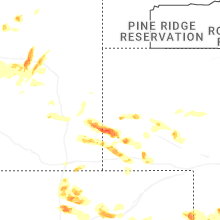
South Dakota
| Local Time | Report Details |
|---|---|
| 1:10 PM CDT | Quarter sized hail reported near White Lake, SD, 75.5 miles N of Oneill, NE |
| 2:19 PM CDT | Quarter sized hail reported near Dimock, SD, 73.5 miles W of Sioux Falls, SD, in addition to quarter sized hail... thunderstorm wind gusts were about 30 mph. |
| 2:45 PM CDT | Golf Ball sized hail reported near Tyndall, SD, 57.4 miles NE of Oneill, NE, although some hail was as big as a golf ball... most stones were dime to quarter sized. rainfall was 0.25 inch in about 5 minutes. |
| 3:27 PM CDT | Quarter sized hail reported near Yankton, SD, 55.3 miles SW of Sioux Falls, SD, report from mping: quarter (1.00 in.). |
| 3:30 PM CDT | Quarter sized hail reported near Yankton, SD, 55.8 miles SW of Sioux Falls, SD, nickel to quarter size hail. |
| 4:12 PM CDT | Quarter sized hail reported near Olivet, SD, 52.2 miles WSW of Sioux Falls, SD, nickel to quarter size hail with second round of hail in olivet. first round was pea size. |
| 4:23 PM CDT | Quarter sized hail reported near Menno, SD, 45.2 miles WSW of Sioux Falls, SD, hail as big as a quarter... but most was pea to nickel sized. not much wind... and 0.62 inch rainfall. |
| 7:57 PM MDT | Quarter sized hail reported near Nemo, SD, 15.8 miles WNW of Rapid City, SD |
North Carolina
| Local Time | Report Details |
|---|---|
| 2:50 PM EDT | Thunderstorm winds blew down one tree along the 3300 block of westfield roa in surry county NC, 62.7 miles SSW of Roanoke, VA |
| 7:05 PM EDT | 10 inch diameter tree branch down on hous in randolph county NC, 56.4 miles W of Raleigh, NC |
| 7:30 PM EDT | Tree down. time estimated based on rada in lee county NC, 41.4 miles WSW of Raleigh, NC |
| 7:30 PM EDT | Tree down. time estimated based on rada in lee county NC, 37.2 miles SW of Raleigh, NC |
| 7:45 PM EDT | Tree down across roadwa in chatham county NC, 35.1 miles WSW of Raleigh, NC |
| 8:38 PM EDT | Tree down on wade-stedman roa in cumberland county NC, 43.9 miles S of Raleigh, NC |
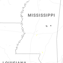
Mississippi
| Local Time | Report Details |
|---|---|
| 2:10 PM CDT | Tree down blocking clara foote roa in rankin county MS, 15.6 miles SE of Jackson, MS |
| 2:25 PM CDT | Tree down on rankin roa in rankin county MS, 15.9 miles E of Jackson, MS |
| 2:58 PM CDT | Trees down near hwy 13 and ludlow roa in scott county MS, 36.5 miles ENE of Jackson, MS |
| 3:09 PM CDT | Trees down on arundel roa in lauderdale county MS, 80.4 miles S of Starkville, MS |
| 3:10 PM CDT | Measured 61 mph gust at kme in lauderdale county MS, 77.7 miles S of Starkville, MS |
| 3:20 PM CDT | Trees were downed on hickory ln... steeplechase dr... and northdale d in lowndes county MS, 23.1 miles E of Starkville, MS |
| 3:26 PM CDT | A few trees down in the bailey are in lauderdale county MS, 68.8 miles S of Starkville, MS |
| 3:27 PM CDT | A few trees dow in lauderdale county MS, 72.7 miles S of Starkville, MS |
| 3:36 PM CDT | A few trees down around town. one tree on a power lin in neshoba county MS, 51 miles SSW of Starkville, MS |
| 3:37 PM CDT | Couple trees dow in neshoba county MS, 55.5 miles SSW of Starkville, MS |
| 3:44 PM CDT | A few trees dow in neshoba county MS, 45.9 miles SSW of Starkville, MS |
| 4:26 PM CDT | Tree down on washington street. multiple power outages in the county as wel in noxubee county MS, 28.6 miles SSE of Starkville, MS |
Indiana
| Local Time | Report Details |
|---|---|
| 2:10 PM CDT | Trees uprooted and limbs damaged from high win in posey county IN, 18.4 miles W of Evansville, IN |
Virginia
| Local Time | Report Details |
|---|---|
| 4:24 PM EDT | Thunderstorm winds blew down multiple trees near the intersection of morgan ford road and axton roa in henry county VA, 50.4 miles SSE of Roanoke, VA |
Nebraska
| Local Time | Report Details |
|---|---|
| 4:00 PM CDT | Mesonet measured wind gust of 58 mp in cedar county NE, 64.1 miles SSW of Sioux Falls, SD |
| 4:00 PM CDT | Mesonet measured wind gust of 63 mp in cedar county NE, 65.7 miles SSW of Sioux Falls, SD |
| 4:02 PM CDT | Quarter sized hail reported near Hartington, NE, 69.4 miles SSW of Sioux Falls, SD |
| 4:28 PM CDT | Report via social media. trees knocked down by thunderstorm wind gust in dixon county NE, 76.1 miles S of Sioux Falls, SD |
| 4:30 PM CDT | Emergency management report of irrigation flipped two miles south of laurel along with power lines down in that area. time estimated with rada in cedar county NE, 79.3 miles E of Oneill, NE |
| 5:05 PM CDT | Quarter sized hail reported near Pierce, NE, 58.1 miles ESE of Oneill, NE, public report of hail estimated up to 1 inch in diameter. |
| 5:11 PM CDT | Half Dollar sized hail reported near Pierce, NE, 60 miles ESE of Oneill, NE, accompanied by 45 mph winds. |
| 5:13 PM CDT | Emergency management report of heavy rain and wind gusts of 50-60 mp in thurston county NE, 70.9 miles NW of Omaha, NE |
| 5:13 PM CDT | Emergency management report of straight line winds gusting at 60-65 mp in thurston county NE, 71.5 miles NNW of Omaha, NE |
| 5:15 PM CDT | Quarter sized hail reported near Pierce, NE, 62.2 miles ESE of Oneill, NE, law enforcement report of hail up to quarter sized along with heavy rain. |
| 5:40 PM CDT | Quarter sized hail reported near Neligh, NE, 38.9 miles SE of Oneill, NE, delayed public report shared on social media with a hailstone measured at 1 inch in diameter. time estimated from radar. |
| 5:43 PM CDT | Quarter sized hail reported near Meadow Grove, NE, 55.2 miles ESE of Oneill, NE |
| 6:10 PM CDT | Quarter sized hail reported near Neligh, NE, 39 miles SE of Oneill, NE |
| 6:17 PM CDT | Personal weather station measured wind gust of 64 mp in cuming county NE, 57.6 miles NW of Omaha, NE |
| 6:17 PM CDT | Ping Pong Ball sized hail reported near Norfolk, NE, 71.3 miles ESE of Oneill, NE |
| 6:20 PM CDT | Quarter sized hail reported near Norfolk, NE, 75.2 miles ESE of Oneill, NE |
| 6:22 PM CDT | Quarter sized hail reported near Norfolk, NE, 70.7 miles ESE of Oneill, NE |
| 7:06 PM CDT | Report of snapped tree limbs of 3 inches in diamete in washington county NE, 23.2 miles NW of Omaha, NE |
| 7:21 PM CDT | Personal weather station measured wind gust of 64 mp in douglas county NE, 15.9 miles WNW of Omaha, NE |
| 7:21 PM CDT | Personal weather station measured wind gust of 64 mp in saunders county NE, 30.1 miles WNW of Omaha, NE |
| 7:25 PM CDT | Tennis Ball sized hail reported near Wellfleet, NE, 21.7 miles SSW of North Platte, NE |
| 7:32 PM CDT | Quarter sized hail reported near Newman Grove, NE, 59.3 miles NNE of Grand Island, NE |
| 7:48 PM CDT | Personal weather station measured wind gust of 63 mp in lancaster county NE, 34.5 miles WSW of Omaha, NE |
| 8:09 PM CDT | Quarter sized hail reported near Maxwell, NE, 12.3 miles ESE of North Platte, NE, corrects previous hail report from 2 sw maxwell. |
| 8:09 PM CDT | Golf Ball sized hail reported near Genoa, NE, 55.9 miles NE of Grand Island, NE |
| 8:15 PM CDT | Preliminary reports of of tree and power line damage in town. extent unknown at this tim in dawson county NE, 58.9 miles ESE of North Platte, NE |
| 8:15 PM CDT | Intense gusts several miles out ahead of nearby thunderstorms. dispatch reporting some tree and power line damag in dawson county NE, 57.2 miles ESE of North Platte, NE |
| 8:19 PM CDT | Quarter sized hail reported near Genoa, NE, 48.2 miles NE of Grand Island, NE |
| 8:24 PM CDT | Quarter sized hail reported near Greeley, NE, 44.3 miles NNW of Grand Island, NE, up to quarter size hail...most smaller. |
| 8:25 PM CDT | Quarter sized hail reported near Cedar Rapids, NE, 44.9 miles NNE of Grand Island, NE |
| 8:29 PM CDT | Quarter sized hail reported near Callaway, NE, 44.6 miles E of North Platte, NE, quarter size hail. |
| 8:31 PM CDT | Personal weather station measured gust of 61 mph... likely associated with the passing of an outflow boundar in seward county NE, 64.6 miles WSW of Omaha, NE |
| 8:43 PM CDT | Quarter sized hail reported near Maxwell, NE, 12.3 miles ESE of North Platte, NE |
| 8:45 PM CDT | Quarter sized hail reported near Belgrade, NE, 43.7 miles NNE of Grand Island, NE |
| 8:55 PM CDT | Several reports of branches at least 2 to 4 inch diameter down in town... including from off-duty nw in polk county NE, 44.9 miles ENE of Grand Island, NE |
| 8:55 PM CDT | Large branch down on property. reports of several other reports of 2 to 4 inch branches down in tow in polk county NE, 44.9 miles ENE of Grand Island, NE |
| 9:14 PM CDT | Quarter sized hail reported near Hayes Center, NE, 38.9 miles SSW of North Platte, NE |
| 9:16 PM CDT | Brief wind gusts up to 60 mp in howard county NE, 25.4 miles NW of Grand Island, NE |
| 9:18 PM CDT | Estimated winds 50 to 60 mph... also hail up to dime siz in sherman county NE, 39 miles NW of Grand Island, NE |
| 9:20 PM CDT | Quarter sized hail reported near Ansley, NE, 59.6 miles WNW of Grand Island, NE, report from mping. |
| 9:28 PM CDT | Estimated 40-50 mph persisting winds with brief gusts up to 60 mp in dawson county NE, 57.1 miles W of Grand Island, NE |
| 9:28 PM CDT | Estimated brief 60 mph wind gus in howard county NE, 22.6 miles WNW of Grand Island, NE |
| 9:34 PM CDT | Golf Ball sized hail reported near Sutherland, NE, 19.2 miles W of North Platte, NE |
| 9:40 PM CDT | Report from site kneraven1 in buffalo county NE, 22.2 miles WNW of Grand Island, NE |
| 8:43 PM MDT | Quarter sized hail reported near Wauneta, NE, 62.8 miles SW of North Platte, NE, also reported 50 to 60mph winds. |
| 10:06 PM CDT | Storm damage reported in valley county NE, 57.5 miles NNW of Grand Island, NE |
| 10:08 PM CDT | Storm damage reported in hall county NE, 3.5 miles NNE of Grand Island, NE |
| 10:10 PM CDT | Estimated 60 to 65 mph winds at nws hastings offic in adams county NE, 19.1 miles S of Grand Island, NE |
| 10:13 PM CDT | Storm damage reported in adams county NE, 22.9 miles SSW of Grand Island, NE |
| 10:13 PM CDT | Em reports some trees down and powerline on a car near center of cit in adams county NE, 23.2 miles S of Grand Island, NE |
| 10:16 PM CDT | Storm damage reported in adams county NE, 27.1 miles S of Grand Island, NE |
| 10:16 PM CDT | Storm damage reported in adams county NE, 26.4 miles SSW of Grand Island, NE |
| 10:18 PM CDT | Storm damage reported in adams county NE, 24.6 miles SSW of Grand Island, NE |
| 10:19 PM CDT | Storm damage reported in adams county NE, 28.5 miles SSW of Grand Island, NE |
| 10:21 PM CDT | Storm damage reported in adams county NE, 22.4 miles S of Grand Island, NE |
| 10:33 PM CDT | Storm damage reported in harlan county NE, 74.8 miles SW of Grand Island, NE |
| 10:38 PM CDT | Site wl-huntley3.86en in harlan county NE, 66.3 miles SW of Grand Island, NE |
| 10:40 PM CDT | Social media report of estimated 60 mph wind gus in adams county NE, 33.5 miles S of Grand Island, NE |
| 10:43 PM CDT | Storm damage reported in harlan county NE, 70.4 miles SW of Grand Island, NE |
| 10:45 PM CDT | Storm damage reported in franklin county NE, 64.5 miles SW of Grand Island, NE |
| 10:46 PM CDT | Storm damage reported in harlan county NE, 75.1 miles SW of Grand Island, NE |
| 10:47 PM CDT | Storm damage reported in harlan county NE, 71.8 miles SW of Grand Island, NE |
| 10:48 PM CDT | Storm damage reported in harlan county NE, 72.3 miles SW of Grand Island, NE |
| 10:50 PM CDT | Site pws-knewilco2 in franklin county NE, 63.7 miles SW of Grand Island, NE |
| 10:53 PM CDT | Site wl-bloomington8.16nn in franklin county NE, 63.7 miles SW of Grand Island, NE |
| 11:01 PM CDT | Storm damage reported in harlan county NE, 75.1 miles SW of Grand Island, NE |
| 11:19 PM CDT | Storm damage reported in franklin county NE, 65.3 miles SSW of Grand Island, NE |
| 12:17 AM MDT | Ping Pong Ball sized hail reported near Scottsbluff, NE, 2.3 miles ENE of Scottsbluff, NE |
| 12:21 AM MDT | Golf Ball sized hail reported near Scottsbluff, NE, 0.9 miles NE of Scottsbluff, NE |
| 12:31 AM MDT | Quarter sized hail reported near Bushnell, NE, 35.3 miles SSW of Scottsbluff, NE |
| 12:52 AM MDT | Golf Ball sized hail reported near Lyman, NE, 18 miles WSW of Scottsbluff, NE, several house windows blown out by hailstones. |
| 12:58 AM MDT | Quarter sized hail reported near Kimball, NE, 43.6 miles S of Scottsbluff, NE |
| 1:45 AM MDT | Quarter sized hail reported near Kimball, NE, 28.6 miles S of Scottsbluff, NE |
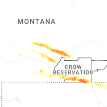
Montana
| Local Time | Report Details |
|---|---|
| 3:09 PM MDT | Quarter sized hail reported near Red Lodge, MT, 51.6 miles SW of Billings, MT, mostly pea to half inch hail with a few quarter size hailstones mixed in. |
| 3:13 PM MDT | Half Dollar sized hail reported near Red Lodge, MT, 50.4 miles SW of Billings, MT |
| 3:44 PM MDT | Quarter sized hail reported near Big Timber, MT, 53.4 miles ENE of Bozeman, MT |
| 4:41 PM MDT | Storm damage reported in yellowstone county MT, 11.7 miles WNW of Billings, MT |
| 5:03 PM MDT | Storm damage reported in yellowstone county MT, 4.6 miles WSW of Billings, MT |
| 5:05 PM MDT | Quarter sized hail reported near Laurel, MT, 15 miles WSW of Billings, MT |
| 5:06 PM MDT | Estimated 60-70 mph. very large tree branches dow in yellowstone county MT, 9 miles NNE of Billings, MT |
| 5:10 PM MDT | Mesonet station huntley in yellowstone county MT, 16.7 miles NE of Billings, MT |
| 5:16 PM MDT | Mesonet station mtyrb 3.1 sw lockwood (mt dot in yellowstone county MT, 1.8 miles ENE of Billings, MT |
| 5:21 PM MDT | Mesonet station sdam8 soda spring in yellowstone county MT, 6.3 miles SE of Billings, MT |
| 5:25 PM MDT | Quarter sized hail reported near Shepherd, MT, 12.6 miles NNE of Billings, MT, pea to quarter size hail accumulating up to 8 inches. |
| 5:25 PM MDT | Extensive tree damage. several roof tops in area damaged or ripped u in yellowstone county MT, 12.6 miles NNE of Billings, MT |
| 5:26 PM MDT | Ping Pong Ball sized hail reported near Huntley, MT, 14.9 miles NE of Billings, MT |
Alabama
| Local Time | Report Details |
|---|---|
| 4:25 PM CDT | Tree down near the intersection of cr 21 and cr 5 in hale county AL, 63.4 miles SW of Birmingham, AL |
| 4:40 PM CDT | Trees and power lines down in the aliceville are in pickens county AL, 44.8 miles ESE of Starkville, MS |
| 4:46 PM CDT | Trees and power lines down in the pickensville are in pickens county AL, 35.4 miles ESE of Starkville, MS |
| 4:50 PM CDT | Trees down in the duncanville are in tuscaloosa county AL, 48.3 miles SW of Birmingham, AL |
| 4:54 PM CDT | Trees and power lines down in the carrollton are in pickens county AL, 44.1 miles ESE of Starkville, MS |
| 5:20 PM CDT | Trees down in the vance are in tuscaloosa county AL, 34.2 miles SW of Birmingham, AL |
| 5:32 PM CDT | Trees down in the samantha are in tuscaloosa county AL, 46.1 miles W of Birmingham, AL |
| 5:43 PM CDT | Trees down in the lake view are in tuscaloosa county AL, 25.2 miles SW of Birmingham, AL |
| 6:16 PM CDT | Tree down near highway 78 and main street. time estimated from rada in jefferson county AL, 10.6 miles NW of Birmingham, AL |
| 6:16 PM CDT | Trees down. time estimated from rada in jefferson county AL, 7.1 miles NW of Birmingham, AL |
| 6:42 PM CDT | Various reports of trees down across center point. time estimated from rada in jefferson county AL, 11.2 miles NE of Birmingham, AL |
| 6:42 PM CDT | Trees down around palmerdale. time estimated from rada in jefferson county AL, 18.1 miles NNE of Birmingham, AL |
| 7:03 PM CDT | Tree down on house. time estimated from rada in tallapoosa county AL, 37 miles NW of Auburn, AL |
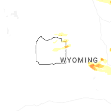
Wyoming
| Local Time | Report Details |
|---|---|
| 3:40 PM MDT | Quarter sized hail reported near Cheyenne, WY, 43.1 miles ESE of Laramie, WY |
| 3:45 PM MDT | Hen Egg sized hail reported near Casper, WY, 7.5 miles WNW of Casper, WY, center manager of the casper interagency dispatch center reported egg size hail. |
| 4:48 PM MDT | Hen Egg sized hail reported near Casper, WY, 7.9 miles WNW of Casper, WY, em reported closer to 2 and a quarter inch size hail. |
| 5:15 PM MDT | Quarter sized hail reported near Douglas, WY, 46.9 miles E of Casper, WY, consistently hailing to quarter size. |
| 5:30 PM MDT | Quarter sized hail reported near Douglas, WY, 48.1 miles E of Casper, WY |
| 5:42 PM MDT | Golf Ball sized hail reported near Glenrock, WY, 30.9 miles E of Casper, WY, time estimated via radar. |
| 6:00 PM MDT | Golf Ball sized hail reported near Ranchester, WY, 81 miles SE of Billings, MT, estimated 60 mph wind gust. |
| 7:50 PM MDT | Golf Ball sized hail reported near Arvada, WY, 36.5 miles NW of Gillette, WY |
| 7:51 PM MDT | Golf Ball sized hail reported near Gillette, WY, 33.4 miles NNW of Gillette, WY |
| 7:57 PM MDT | Ping Pong Ball sized hail reported near Recluse, WY, 33.1 miles NNW of Gillette, WY |
| 8:20 PM MDT | Quarter sized hail reported near Casper, WY, 6.7 miles WSW of Casper, WY, at least quarter sized hail. |
| 8:33 PM MDT | Half Dollar sized hail reported near Weston, WY, 26 miles NNE of Gillette, WY |
| 8:51 PM MDT | Storm damage reported in campbell county WY, 20.6 miles NW of Gillette, WY |
| 10:06 PM MDT | Storm damage reported in weston county WY, 48.8 miles ESE of Gillette, WY |
| 11:35 PM MDT | Golf Ball sized hail reported near Meriden, WY, 41 miles SW of Scottsbluff, NE |
| 12:49 AM MDT | Half Dollar sized hail reported near Yoder, WY, 31.8 miles W of Scottsbluff, NE |
North Dakota
| Local Time | Report Details |
|---|---|
| 6:25 PM CDT | Mchenry county sheriffs office and other trained weather spotters report and sent photos of two large grain silos knocked over with other close by grain silos damaged f in mchenry county ND, 25.8 miles SE of Minot, ND |
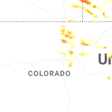
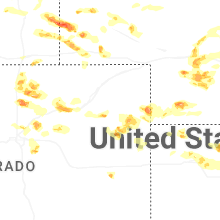
Colorado
| Local Time | Report Details |
|---|---|
| 6:40 PM MDT | Quarter sized hail reported near Idalia, CO, 36.6 miles SE of Yuma, CO, social media report of 1 inch hail. |
| 2:21 AM MDT | Ping Pong Ball sized hail reported near Wellington, CO, 53.7 miles SE of Laramie, WY |
| 2:30 AM MDT | Tennis Ball sized hail reported near Wellington, CO, 52.2 miles SE of Laramie, WY |
| 2:33 AM MDT | Half Dollar sized hail reported near Eaton, CO, 55.9 miles NNE of Denver, CO, report from mping: half dollar (1.25 in.). |
| 2:36 AM MDT | Hen Egg sized hail reported near Wellington, CO, 52.5 miles SE of Laramie, WY, report from mping: hen egg (2.00 in.). |
| 2:38 AM MDT | Half Dollar sized hail reported near Greeley, CO, 52.5 miles NNE of Denver, CO, report from mping: half dollar (1.25 in.). |
| 2:39 AM MDT | Golf Ball sized hail reported near Eaton, CO, 55.6 miles NNE of Denver, CO, report from mping: golf ball (1.75 in.). |
| 2:49 AM MDT | Quarter sized hail reported near Gill, CO, 54.5 miles NNE of Denver, CO, report from mping: quarter (1.00 in.). |
| 3:02 AM MDT | Half Dollar sized hail reported near Fort Collins, CO, 58.9 miles SE of Laramie, WY, report from mping: half dollar (1.25 in.). |
| 3:24 AM MDT | Quarter sized hail reported near Johnstown, CO, 40.8 miles N of Denver, CO, report from mping: quarter (1.00 in.). |
| 3:28 AM MDT | Quarter sized hail reported near Milliken, CO, 42.6 miles N of Denver, CO, report from mping: quarter (1.00 in.). |
| 3:31 AM MDT | Half Dollar sized hail reported near Milliken, CO, 42.6 miles N of Denver, CO, report from mping: half dollar (1.25 in.). |
| 3:34 AM MDT | Hen Egg sized hail reported near Milliken, CO, 42.6 miles N of Denver, CO, report from mping: hen egg (2.00 in.). |
| 3:40 AM MDT | Ping Pong Ball sized hail reported near Milliken, CO, 41.5 miles N of Denver, CO |
| 3:48 AM MDT | Ping Pong Ball sized hail reported near Eaton, CO, 55.9 miles NNE of Denver, CO, report from mping: ping pong ball (1.50 in.). |
| 4:01 AM MDT | Half Dollar sized hail reported near Greeley, CO, 52.5 miles NNE of Denver, CO, report from mping: half dollar (1.25 in.). |
| 4:15 AM MDT | Half Dollar sized hail reported near Brighton, CO, 13.7 miles NNE of Denver, CO |
| 4:16 AM MDT | Quarter sized hail reported near Brighton, CO, 16.3 miles NNE of Denver, CO, report from mping: quarter (1.00 in.). |
| 4:21 AM MDT | Quarter sized hail reported near Brighton, CO, 13.8 miles NNE of Denver, CO, report from mping: quarter (1.00 in.). |
| 4:21 AM MDT | Quarter sized hail reported near Brighton, CO, 17 miles NNE of Denver, CO, report from mping: quarter (1.00 in.). |
| 4:22 AM MDT | Quarter sized hail reported near Brighton, CO, 14.5 miles NNE of Denver, CO, report from mping: quarter (1.00 in.). |
| 4:25 AM MDT | Half Dollar sized hail reported near Fort Morgan, CO, 58.7 miles W of Yuma, CO, report from mping: half dollar (1.25 in.). |
| 4:26 AM MDT | Quarter sized hail reported near Fort Morgan, CO, 57.8 miles W of Yuma, CO, report from mping: quarter (1.00 in.). |
| 4:32 AM MDT | Quarter sized hail reported near Fort Morgan, CO, 57.7 miles W of Yuma, CO, report from mping: quarter (1.00 in.). |
| 4:39 AM MDT | Ping Pong Ball sized hail reported near Brighton, CO, 18.3 miles NE of Denver, CO, report from mping: ping pong ball (1.50 in.). |
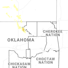
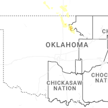
Oklahoma
| Local Time | Report Details |
|---|---|
| 6:05 AM CDT | Storm damage reported in kay county OK, 60.4 miles SSE of Wichita, KS |
Connect with Interactive Hail Maps