

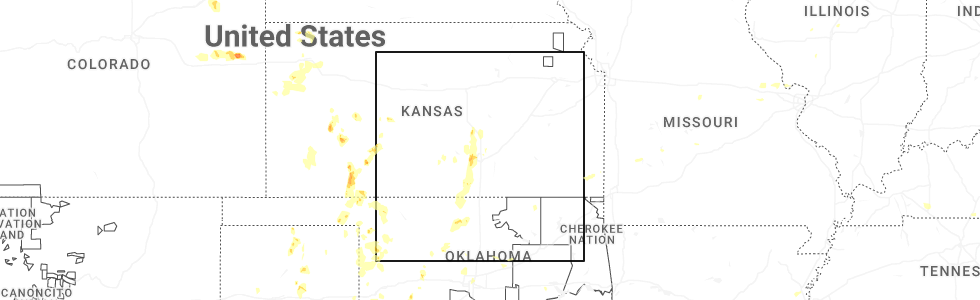
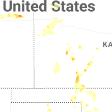
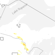
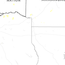
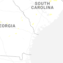
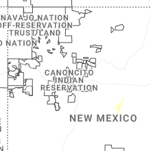
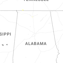
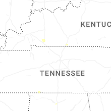
Hail Map for Tuesday, July 8, 2025
Number of Impacted Households on 7/8/2025
0
Impacted by 1" or Larger Hail
0
Impacted by 1.75" or Larger Hail
0
Impacted by 2.5" or Larger Hail
Square Miles of Populated Area Impacted on 7/8/2025
0
Impacted by 1" or Larger Hail
0
Impacted by 1.75" or Larger Hail
0
Impacted by 2.5" or Larger Hail
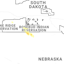

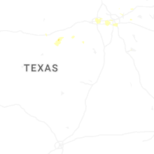
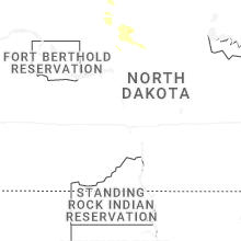
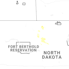
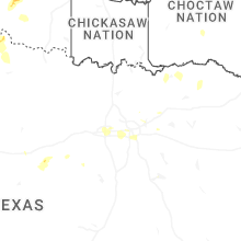


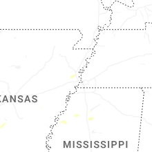
Cities Most Affected by Hail Storms of 7/8/2025
| Hail Size | Demographics of Zip Codes Affected | ||||||
|---|---|---|---|---|---|---|---|
| City | Count | Average | Largest | Pop Density | House Value | Income | Age |
| Ensign, KS | 2 | 1.88 | 2.00 | 2 | $46k | $43.8k | 41.9 |
| Garden City, KS | 1 | 2.00 | 2.00 | 44 | $85k | $38.1k | 30.2 |
| Cimarron, KS | 1 | 2.00 | 2.00 | 2 | $80k | $40.2k | 34.1 |
| Goddard, KS | 1 | 1.75 | 1.75 | 141 | $112k | $53.4k | 33.6 |
Hail and Wind Damage Spotted on 7/8/2025
Filter by Report Type:Hail ReportsWind Reports
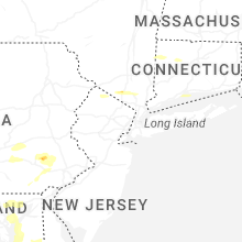
States Impacted
New York, Connecticut, New Jersey, Pennsylvania, Kentucky, Virginia, Alabama, Maryland, Michigan, Missouri, Mississippi, Wisconsin, Illinois, New Mexico, Kansas, Colorado, North Carolina, Oklahoma, Texas, Delaware, Idaho, Arizona, Massachusetts, Rhode IslandNew York
| Local Time | Report Details |
|---|---|
| 1:35 PM EDT | Tree down on the exit 16 ramp of the palisades interstate parkwa in rockland county NY, 38.6 miles N of Brooklyn, NY |
| 1:55 PM EDT | Large tree down on power line in westchester county NY, 36.6 miles N of Brooklyn, NY |
| 2:07 PM EDT | Dot tree down across rte 129. all lanes blocke in westchester county NY, 38.4 miles N of Brooklyn, NY |
| 2:08 PM EDT | Tree down causing the closure of jersey avenu in passaic county NJ, 38.7 miles NNW of Brooklyn, NY |
| 2:30 PM EDT | Tree down on route 202 near mayer drive. right lane is closed. time estimated by rada in rockland county NY, 31.1 miles NNW of Brooklyn, NY |
| 2:30 PM EDT | Corrects previous tstm wnd dmg report from 1 nne montebello. large tree fell onto a truck on kevin drive. the tree also blocked the road and took down power lines. time in rockland county NY, 31.5 miles NNW of Brooklyn, NY |
| 2:30 PM EDT | Large tree fell onto a truck on kevin drive. the tree also blocked the road and took down power line in rockland county NY, 31.5 miles NNW of Brooklyn, NY |
| 8:56 PM EDT | Mesonet station xbay bayvill in nassau county NY, 23.7 miles NE of Brooklyn, NY |
Connecticut
| Local Time | Report Details |
|---|---|
| 1:38 PM EDT | Multiple trees and wires downed on route 7. the roadway was closed to traffi in litchfield county CT, 76.4 miles NNE of Brooklyn, NY |
| 1:40 PM EDT | Tree down on wires on cornwall roa in litchfield county CT, 77 miles SSE of Schenectady, NY |
| 1:59 PM EDT | Social media report of multiple downed trees... including one that damaged an outhouse... near the white memorial conservation center. time estimated from rada in litchfield county CT, 81.7 miles NNE of Brooklyn, NY |
| 9:05 PM EDT | Mesonet site xgll at greens ledge ligh in anz335 county CT, 37.5 miles NE of Brooklyn, NY |
| 9:19 PM EDT | Corrects previous non-tstm wnd gst report from 2 ese norwalk. mesonet station xnor 1 ese norwal in anz335 county CT, 41.7 miles NE of Brooklyn, NY |
| 11:45 PM EDT | Tree down blocking part of riverside drive in thompson. relayed by amateur radi in windham county CT, 25.9 miles WNW of Providence, RI |
| 11:50 PM EDT | Northbound side of i-395 between mile markers 37-38 near killingly had a large tree blocking the right lane. relayed by amateur radi in windham county CT, 24.2 miles W of Providence, RI |
New Jersey
| Local Time | Report Details |
|---|---|
| 1:42 PM EDT | Tree and wire downed from oem. time es in sussex county NJ, 48.2 miles NW of Brooklyn, NY |
| 2:07 PM EDT | Tree and wires dow in passaic county NJ, 35.9 miles NW of Brooklyn, NY |
| 2:11 PM EDT | Trees on wires across rocky point roa in passaic county NJ, 37.3 miles NNW of Brooklyn, NY |
| 2:15 PM EDT | Trees on wire in passaic county NJ, 38.3 miles NNW of Brooklyn, NY |
| 2:26 PM EDT | Trees and wires down at lake shore drive/warwick tp in passaic county NJ, 38.2 miles NNW of Brooklyn, NY |
| 6:15 PM EDT | Numerous trees and wires down... with some roadways blocked. time estimated from rada in burlington county NJ, 62.9 miles SW of Brooklyn, NY |
| 6:15 PM EDT | Wires dow in burlington county NJ, 71.2 miles SW of Brooklyn, NY |
| 6:17 PM EDT | Trees and lines down throughout ewing. time estimated from rada in mercer county NJ, 51.7 miles SW of Brooklyn, NY |
| 6:19 PM EDT | 58 mph wind gust occurred at trenton mercer airpor in mercer county NJ, 51.7 miles WSW of Brooklyn, NY |
| 6:20 PM EDT | Trees and powerlines down across rt in mercer county NJ, 48.3 miles SW of Brooklyn, NY |
| 6:21 PM EDT | Several tree limbs down. estimated 60 mph gus in burlington county NJ, 65 miles SW of Brooklyn, NY |
| 6:28 PM EDT | As of 7:00pm... theres a downed tree on i-295 southbound south of exit 52 - columbus rd in florence twp. 1 left lane of 3 lanes closed. time estimated from rada in burlington county NJ, 58.6 miles SW of Brooklyn, NY |
| 6:30 PM EDT | As of 6:48pm... theres a downed tree on us 1 southbound north of franklin corner rd/bakers basin rd in lawrence twp. all lanes closed. time estimated from rada in mercer county NJ, 47 miles SW of Brooklyn, NY |
| 6:38 PM EDT | Numerous trees and wires down. time estimated from rada in burlington county NJ, 61.7 miles SW of Brooklyn, NY |
| 6:40 PM EDT | Wires downe in ocean county NJ, 51.5 miles SSW of Brooklyn, NY |
| 6:43 PM EDT | Multiple large branches downe in monmouth county NJ, 49.2 miles SW of Brooklyn, NY |
| 7:04 PM EDT | Large tree down blocking big oak road. time estimated from rada in cumberland county NJ, 79.7 miles N of Ocean City, MD |
| 7:05 PM EDT | Fortescue nj weather ne in anz430 county NJ, 63.4 miles N of Ocean City, MD |
| 7:16 PM EDT | Trees down on kent road near ford road. road closed. time estimated from rada in monmouth county NJ, 41.5 miles SSW of Brooklyn, NY |
| 7:25 PM EDT | Tree into a home. time estimated from rada in monmouth county NJ, 24.5 miles S of Brooklyn, NY |
| 7:25 PM EDT | Trees and wires down. time estimated from rada in monmouth county NJ, 24.5 miles S of Brooklyn, NY |
| 7:36 PM EDT | Sandy hook nos gauge gusted to 63 mph (55 kts in monmouth county NJ, 15.4 miles S of Brooklyn, NY |
Pennsylvania
| Local Time | Report Details |
|---|---|
| 1:58 PM EDT | Tree on wires on 200 block hower r in juniata county PA, 31.8 miles ESE of State College, PA |
| 2:47 PM EDT | Tree down blocking the roadway on clarks valley roa in dauphin county PA, 56 miles ESE of State College, PA |
| 2:49 PM EDT | Tree down blocking one lane of creek road near the intersection of lehman roa in dauphin county PA, 54.1 miles ESE of State College, PA |
| 3:49 PM EDT | Thunderstorm damage reported in clay townshi in lancaster county PA, 67.4 miles NNE of Baltimore, MD |
| 3:51 PM EDT | Tree down on the 400 block of south race stree in lebanon county PA, 76.2 miles NNE of Baltimore, MD |
| 3:52 PM EDT | Tree and wires down on west market street near the intersection of south royal stree in york county PA, 46.8 miles N of Baltimore, MD |
| 3:56 PM EDT | Tree onto wire in berks county PA, 71.6 miles SSW of Scranton, PA |
| 4:00 PM EDT | Tree down on a house on the 300 block of greenville road. no injuries reporte in lancaster county PA, 71 miles NNE of Baltimore, MD |
| 4:03 PM EDT | Thunderstorm damage reported in west cocalico townshi in lancaster county PA, 71.2 miles NNE of Baltimore, MD |
| 4:21 PM EDT | Reports of storm damage on the 200 block of hopeland roa in lancaster county PA, 67 miles NNE of Baltimore, MD |
| 4:26 PM EDT | Picture of large trees down in kenhorst. time estimated from rada in berks county PA, 77.4 miles SSW of Scranton, PA |
| 4:26 PM EDT | Picture of large trees down in shartlesville... pa. time estimated from rada in berks county PA, 66.4 miles SSW of Scranton, PA |
| 4:31 PM EDT | Trees down on powerlines causing a fire on bailey crossroads rd. time estimated from rada in chester county PA, 54.5 miles NE of Baltimore, MD |
| 4:38 PM EDT | Tree down on a residence. time estimated from rada in berks county PA, 79.4 miles S of Scranton, PA |
| 4:43 PM EDT | Picture of large trees down on wires on seyfert drive in birdsboro... pa. time estimated from rada in berks county PA, 78.1 miles S of Scranton, PA |
| 4:45 PM EDT | Wires and poles down. time es in chester county PA, 66.9 miles NE of Baltimore, MD |
| 4:59 PM EDT | Quarter sized hail reported near Douglassville, PA, 78.4 miles NNE of Baltimore, MD, relayed via social media. time included with report. |
| 5:01 PM EDT | Report and photos showing a large tree snapped and a shed completed destroyed by wind at a residence on carriage lane in west vincent twp. time estimated from rada in chester county PA, 75.4 miles NE of Baltimore, MD |
| 5:02 PM EDT | Measured 68 mph gust in pottstown. time included in repor in montgomery county PA, 80.1 miles S of Scranton, PA |
| 5:02 PM EDT | Quarter sized hail reported near Pottstown, PA, 80.1 miles S of Scranton, PA, quarter-size hail in pottstown. video sent via social media. time included with report. |
| 5:03 PM EDT | Trees and wires down. time estimated from rada in chester county PA, 74 miles NE of Baltimore, MD |
| 5:05 PM EDT | Pictures of widespread tree damage in upper uwchlan township sent in by an em. time estimated from rada in chester county PA, 72.6 miles NE of Baltimore, MD |
| 5:05 PM EDT | Numerous trees down. time estimated from rada in chester county PA, 76.3 miles NE of Baltimore, MD |
| 5:10 PM EDT | Trees and wires down. time estimated from rada in chester county PA, 79.8 miles NE of Baltimore, MD |
| 5:10 PM EDT | Damage to house shutters... trees down in pottstown. time estimated from rada in montgomery county PA, 80.1 miles S of Scranton, PA |
| 5:13 PM EDT | Tree fell on occupied vehicle. no injurie in chester county PA, 78.2 miles NE of Baltimore, MD |
| 5:13 PM EDT | Large tree down. time estimated from rada in chester county PA, 78.2 miles NE of Baltimore, MD |
| 5:15 PM EDT | Several trees and wires down around pottstown and pottsgrove. time estimated from rada in montgomery county PA, 80.1 miles S of Scranton, PA |
| 5:15 PM EDT | Numerous trees down. time estimated from rada in chester county PA, 82 miles NE of Baltimore, MD |
| 5:19 PM EDT | Trees and wires down. time estimated from rada in montgomery county PA, 75.8 miles S of Scranton, PA |
| 5:19 PM EDT | Trees down in tredyffrin twp. time estimated from rada in chester county PA, 81.9 miles NE of Baltimore, MD |
| 5:19 PM EDT | Trees and wired down. time estimated from rada in chester county PA, 81.4 miles NE of Baltimore, MD |
| 5:22 PM EDT | Cluster of trees and wires down around lower frederick township... pa. time estimated from rada in montgomery county PA, 78.6 miles S of Scranton, PA |
| 5:24 PM EDT | Corrects previous tstm wnd dmg report from west norriton. trees and wires down throughout west norriton. time estimated from rada in montgomery county PA, 82.9 miles WSW of Brooklyn, NY |
| 5:27 PM EDT | Trees and wires down near upper merion township... pa. time estimated from rada in montgomery county PA, 83.9 miles WSW of Brooklyn, NY |
| 5:27 PM EDT | Large tree down blocking roadway at the corner of hillcrest ave and evergreen rd. time estimated from rada in montgomery county PA, 80.9 miles WSW of Brooklyn, NY |
| 5:40 PM EDT | Tree down on i-76 near gulph mill in montgomery county PA, 81 miles WSW of Brooklyn, NY |
| 5:42 PM EDT | Trees and wires down around whitpain township. time estimated from rada in montgomery county PA, 77.3 miles WSW of Brooklyn, NY |
| 6:05 PM EDT | Trees and wires down in lower and upper southampton township. time estimated from rada in bucks county PA, 64.7 miles SW of Brooklyn, NY |
| 6:07 PM EDT | Trees and wires down in trevose. time estimated from rada in bucks county PA, 65 miles SW of Brooklyn, NY |
| 6:10 PM EDT | Trees and wires down. time estimated from rada in bucks county PA, 64.2 miles SW of Brooklyn, NY |
| 6:28 PM EDT | Water rescues and roads closed around the lower and upper southampton area. time estimate in bucks county PA, 65.1 miles SW of Brooklyn, NY |
Kentucky
| Local Time | Report Details |
|---|---|
| 1:20 PM CDT | A few trees down in the cit in christian county KY, 61.5 miles NW of Nashville, TN |
Virginia
| Local Time | Report Details |
|---|---|
| 3:01 PM EDT | Multiple trees reported down in the town of mount jackso in shenandoah county VA, 66.1 miles E of Elkins, WV |
| 3:14 PM EDT | Tree down on berlin turnpike near lovettsvill in loudoun county VA, 55.3 miles W of Baltimore, MD |
| 4:01 PM EDT | Trees down on hume roa in fauquier county VA, 82.7 miles WSW of Baltimore, MD |
| 4:11 PM EDT | Trees down on wolftown hood road south of hoo in greene county VA, 69.9 miles NW of Richmond, VA |
| 5:52 PM EDT | Tree down at the intersection of ferry road and holcomb rock road in bedford county virgini in bedford county VA, 40.4 miles ENE of Roanoke, VA |
| 5:55 PM EDT | A tree fell down along comans well r in sussex county VA, 46.3 miles SSE of Richmond, VA |
| 5:57 PM EDT | Tree down at the intersection of winridge drive and wine sap road in amherst county virgini in amherst county VA, 46 miles ENE of Roanoke, VA |
| 6:03 PM EDT | Tree down at the intersection of dixie airport road and amelon expressway in amherst county virgini in amherst county VA, 48.6 miles ENE of Roanoke, VA |
| 6:05 PM EDT | Corrects previous tstm wnd dmg report from 2 se sussex. tree was knocked down on a house along hines l in sussex county VA, 47.5 miles SSE of Richmond, VA |
| 6:26 PM EDT | Thunderstorm winds blew down one tree near the intersection of stonewall road and vineyard roa in appomattox county VA, 54.8 miles E of Roanoke, VA |
| 6:28 PM EDT | Thunderstorm winds blew down one tree along the 600 block of beckham roa in appomattox county VA, 56.7 miles ENE of Roanoke, VA |
| 7:06 PM EDT | A wind gust of 60 mph was measured by a personal weather station on brittany roa in buckingham county VA, 54.4 miles W of Richmond, VA |
| 7:36 PM EDT | Trees and powerlines down along the richmond beach rd and east circle d in essex county VA, 52.1 miles ENE of Richmond, VA |
| 7:43 PM EDT | A tree fell down along jerusalem plank r in sussex county VA, 50 miles SSE of Richmond, VA |
| 7:45 PM EDT | Tree down on rt. 669 in the county of goochland... in the vicinity of hickory hill rd; rt. 609e/w (goochland county in goochland county VA, 32.5 miles NW of Richmond, VA |
| 7:55 PM EDT | A tree was knocked down along settlers landing r in richmond county VA, 59.4 miles ENE of Richmond, VA |
| 8:05 PM EDT | A tree was down along oakland r in richmond county VA, 64.8 miles ENE of Richmond, VA |
| 8:05 PM EDT | A tree fell along broad street r in goochland county VA, 25.5 miles NW of Richmond, VA |
| 8:06 PM EDT | A tree was knocked down along rock castle r in goochland county VA, 21.3 miles NW of Richmond, VA |
| 8:13 PM EDT | Down tree on rt. 637 in the county of goochland... in the vicinity of rt. 698n/s (goochland county in goochland county VA, 17 miles NW of Richmond, VA |
| 8:42 PM EDT | Thunderstorm winds blew down a power line near the intersection of catawba road and etzler roa in botetourt county VA, 10.9 miles N of Roanoke, VA |
| 8:43 PM EDT | Thunderstorm winds blew down a power line near the intersection of catawba road and glebe roa in botetourt county VA, 10.3 miles N of Roanoke, VA |
| 8:46 PM EDT | Thunderstorm winds blew down a power line near the intersection of glebe road and orchard lake driv in botetourt county VA, 10.3 miles N of Roanoke, VA |
| 9:12 PM EDT | Tree was knocked down on a house along hines l in sussex county VA, 47.5 miles SSE of Richmond, VA |
Alabama
| Local Time | Report Details |
|---|---|
| 2:20 PM CDT | Limestone ema reported several trees down and uprooted along poplar point roa in limestone county AL, 30.8 miles E of Florence, AL |
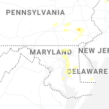
Maryland
| Local Time | Report Details |
|---|---|
| 3:26 PM EDT | Two trees reported down near point of rocks off ballenger creek pik in frederick county MD, 49.9 miles W of Baltimore, MD |
| 4:47 PM EDT | Multiple reports of trees down in callawa in st. marys county MD, 72.6 miles S of Baltimore, MD |
| 4:56 PM EDT | Multiple reports of trees down in columbi in howard county MD, 14.8 miles WSW of Baltimore, MD |
| 4:56 PM EDT | Multiple reports of trees down in lexington par in st. marys county MD, 71.6 miles S of Baltimore, MD |
| 4:56 PM EDT | Multiple reports of trees down in laure in howard county MD, 17.4 miles SW of Baltimore, MD |
| 5:02 PM EDT | Wind gust to 77 mph measured at patuxent naval air station aso in st. marys county MD, 70.5 miles S of Baltimore, MD |
| 5:13 PM EDT | Two trees on a house in white mars in baltimore county MD, 10.1 miles NE of Baltimore, MD |
| 5:18 PM EDT | Multiple calls for trees down in and around bel ai in harford county MD, 21.6 miles NE of Baltimore, MD |
| 5:18 PM EDT | Several trees snapped on walter's mill road in forest hil in harford county MD, 26.9 miles NE of Baltimore, MD |
| 5:31 PM EDT | Multiple calls for trees down in and around churchvill in harford county MD, 26.8 miles NE of Baltimore, MD |
| 5:35 PM EDT | Harford county airport awos gusted to 50 kt / 58 mp in harford county MD, 29.2 miles NE of Baltimore, MD |
| 5:36 PM EDT | Multiple calls for trees down between aberdeen and havre de grac in harford county MD, 28 miles ENE of Baltimore, MD |
| 5:54 PM EDT | Widespread downed trees and wires around rock hall... md. time estimated by rada in kent county MD, 22.4 miles ESE of Baltimore, MD |
| 5:58 PM EDT | Two trees reported down on the north side of elkto in cecil county MD, 47.3 miles ENE of Baltimore, MD |
| 6:00 PM EDT | Numerous trees and wires down in the worton area. time estimated by rada in kent county MD, 27.9 miles E of Baltimore, MD |
| 6:00 PM EDT | Several reports of trees and powerlines down near fairlee. time estimate in kent county MD, 24.1 miles ESE of Baltimore, MD |
| 6:12 PM EDT | Two trees down on sudley road just west of galesvill in anne arundel county MD, 31.1 miles S of Baltimore, MD |
| 6:17 PM EDT | Personal weather station kmdchest61 gusted to 70.2 mp in queen anne's county MD, 32.9 miles ESE of Baltimore, MD |
| 6:26 PM EDT | Multiple trees reported down in and around cecilto in cecil county MD, 40.3 miles E of Baltimore, MD |
| 6:30 PM EDT | Trees down around grasonville. time estimated by rada in queen anne's county MD, 31.3 miles SE of Baltimore, MD |
| 6:30 PM EDT | Downed tree on prospect bay dr. w and gold cart dr. time estimated from rada in queen anne's county MD, 31.7 miles SE of Baltimore, MD |
| 6:30 PM EDT | Trees and wires down across the roadway at price station rd and cox sawmill rd. time estimated from rada in queen anne's county MD, 33.4 miles ESE of Baltimore, MD |
| 6:45 PM EDT | Several trees and wires down around saint michaels. time estimated by rada in talbot county MD, 40.4 miles SSE of Baltimore, MD |
| 6:48 PM EDT | Several trees and power lines down around the royal oak area. time estimated by rada in talbot county MD, 44.5 miles SSE of Baltimore, MD |
| 6:54 PM EDT | Report of a roof collapse of a building near ridgley. time estimated from rada in caroline county MD, 45.7 miles ESE of Baltimore, MD |
| 7:34 PM EDT | 2 trees down near intersection of chingville rd and medleys neck rd in st. marys county MD, 73.3 miles S of Baltimore, MD |
| 8:45 PM EDT | A tree fell down along maiden forest r in dorchester county MD, 46.1 miles WNW of Ocean City, MD |
Michigan
| Local Time | Report Details |
|---|---|
| 2:41 PM CDT | Quarter sized hail reported near Crystal Falls, MI, 57.3 miles ENE of Rhinelander, WI, social media report of quarter size hail in alpha. time estimated from radar. |
| 2:41 PM CDT | Social media report of trees uprooted due to thunderstorm winds in alpha. time estimated using rada in iron county MI, 57.3 miles ENE of Rhinelander, WI |
| 5:10 PM CDT | Quarter sized hail reported near Wallace, MI, 59.6 miles NNE of Green Bay, WI, a local business reports hail the size of quarters in wallace... mi. |
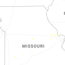
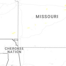
Missouri
| Local Time | Report Details |
|---|---|
| 2:43 PM CDT | Several trees down across mo 94 between hwy b and in warren county MO, 57.5 miles ESE of Columbia, MO |
Mississippi
| Local Time | Report Details |
|---|---|
| 3:38 PM CDT | A tree was reported down off of highway 4 in clay county MS, 13.7 miles NNW of Starkville, MS |
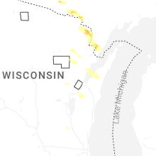
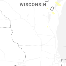
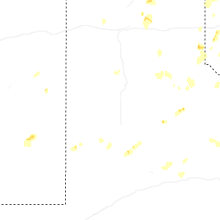
Wisconsin
| Local Time | Report Details |
|---|---|
| 3:41 PM CDT | Trees and power lines down in auror in florence county WI, 62.8 miles E of Rhinelander, WI |
| 4:05 PM CDT | Quarter sized hail reported near Niagara, WI, 66.8 miles SSW of Marquette, MI, report from mping: quarter (1.00 in.). |
| 4:53 PM CDT | Quarter sized hail reported near Wausaukee, WI, 58.2 miles NNE of Green Bay, WI, 1 inch hail reported by local business. time estimated from radar. |
| 5:16 PM CDT | Medium-sized tree splintered at the base and blocking a road. photo received via social media. time estimated from rada in oconto county WI, 28.1 miles N of Green Bay, WI |
| 6:49 PM CDT | Several tree branches down. report via calumet county sheriff offic in calumet county WI, 23.1 miles S of Green Bay, WI |
| 7:47 PM CDT | Dodge county dispatch reports of a fallen tree on horicon st in mayville. time estimated based on rada in dodge county WI, 51.1 miles NE of Madison, WI |
Illinois
| Local Time | Report Details |
|---|---|
| 4:15 PM CDT | Delayed report. tree down on a power line. estimated thunderstorm wind gusts 50 to 60 mp in sangamon county IL, 58.6 miles WNW of Mattoon, IL |
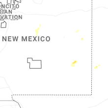
New Mexico
| Local Time | Report Details |
|---|---|
| 3:15 PM MDT | Mesonet station wsm05 san agustin pass 1.6 e organ (wsmr in dona ana county NM, 46.5 miles N of El Paso, TX |
| 5:00 PM MDT | Mesonet station wsm44 tower 6 (wsmr in socorro county NM, 102.6 miles S of Albuquerque, NM |
| 5:05 PM MDT | Mesonet station wsm43 little burro (wsmr in socorro county NM, 102.5 miles S of Albuquerque, NM |
| 5:15 PM MDT | Mesonet station wsm06 pole 616 (wsmr in lincoln county NM, 106.2 miles W of Roswell, NM |
| 5:15 PM MDT | Mesonet station wsm30 phillips hill (wsmr in lincoln county NM, 92.9 miles W of Roswell, NM |
| 5:30 PM MDT | Mesonet station wsm25 wsmr rit in otero county NM, 95.3 miles W of Roswell, NM |
| 5:39 PM MDT | Mesonet station bchn5 carrizozo 15 nw (chupadera in socorro county NM, 94.6 miles WNW of Roswell, NM |
| 5:55 PM MDT | Awos station k4mr tolar 12 s in roosevelt county NM, 60.7 miles S of Tucumcari, NM |
| 5:55 PM MDT | Mesonet station wsm28 wsmr tul in otero county NM, 92.1 miles N of El Paso, TX |
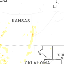
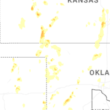
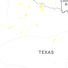
Kansas
| Local Time | Report Details |
|---|---|
| 4:20 PM CDT | Ping Pong Ball sized hail reported near Moundridge, KS, 32.3 miles NNW of Wichita, KS |
| 5:29 PM CDT | Quarter sized hail reported near Wichita, KS, 5.5 miles NE of Wichita, KS |
| 5:30 PM CDT | Report received via social medi in sedgwick county KS, 7.9 miles W of Wichita, KS |
| 5:30 PM CDT | Picture received via social media of 1-foot diameter cottonwood tree blown ove in sedgwick county KS, 9.6 miles W of Wichita, KS |
| 5:32 PM CDT | Quarter sized hail reported near Offerle, KS, 68.8 miles S of Hays, KS, public report via social media with photo. |
| 5:33 PM CDT | Quarter sized hail reported near Goddard, KS, 11.8 miles W of Wichita, KS, report from mping. |
| 5:34 PM CDT | Half Dollar sized hail reported near Goddard, KS, 11.4 miles W of Wichita, KS, report from mping. |
| 5:35 PM CDT | Golf Ball sized hail reported near Goddard, KS, 10.1 miles W of Wichita, KS, report received via social media. |
| 5:42 PM CDT | Quarter sized hail reported near Ingalls, KS, 27.8 miles E of Garden City, KS |
| 5:48 PM CDT | Several limbs down... estimated 65-70 mp in sedgwick county KS, 13.4 miles SW of Wichita, KS |
| 5:50 PM CDT | Hen Egg sized hail reported near Cimarron, KS, 31 miles E of Garden City, KS |
| 5:53 PM CDT | Quarter sized hail reported near Offerle, KS, 69.6 miles S of Hays, KS |
| 5:54 PM CDT | Kansas mesonet sensor measured a peak of 64 mp in sumner county KS, 22.5 miles SW of Wichita, KS |
| 5:54 PM CDT | Reported wind along with half inch sized hai in sedgwick county KS, 17.2 miles SW of Wichita, KS |
| 5:55 PM CDT | 4 diameter limb dow in sedgwick county KS, 16.1 miles SW of Wichita, KS |
| 6:05 PM CDT | Reported from ksu mesonet sit in sumner county KS, 22.5 miles SW of Wichita, KS |
| 6:10 PM CDT | Quarter sized hail reported near Offerle, KS, 69.1 miles SSW of Hays, KS, pictures of 1 inch hail via social media. |
| 6:15 PM CDT | Quarter sized hail reported near Offerle, KS, 68.8 miles S of Hays, KS, pictures of 1 inch hail via social media. |
| 6:44 PM CDT | Quarter sized hail reported near Kingman, KS, 43.6 miles W of Wichita, KS |
| 6:46 PM CDT | Estimated 60-70 mp in sumner county KS, 46.1 miles SSW of Wichita, KS |
| 7:00 PM CDT | Golf Ball sized hail reported near Ensign, KS, 46 miles SE of Garden City, KS |
| 7:04 PM CDT | Hen Egg sized hail reported near Ensign, KS, 46.8 miles SE of Garden City, KS |
| 7:34 PM CDT | Upr meade recorded a 60 mph wind gust at 7:34 cd in meade county KS, 55.1 miles SE of Garden City, KS |
| 7:36 PM CDT | Quarter sized hail reported near Fowler, KS, 53.7 miles SE of Garden City, KS, picture via social media of 1 inch hail. |
| 8:15 PM CDT | Quarter sized hail reported near Englewood, KS, 52.5 miles NW of Woodward, OK |
| 8:40 PM CDT | Hen Egg sized hail reported near Garden City, KS, 17.9 miles NE of Garden City, KS, multiple 2 inch stones in a picture via social media. |
| 10:31 PM CDT | Mesonet station up840 9.0 w winona (upr in logan county KS, 33.1 miles SW of Colby, KS |
Colorado
| Local Time | Report Details |
|---|---|
| 3:28 PM MDT | Report via social media. measured a 50 mph gust using a handheld anemometer. a few trees down along with numerous 1-3 inch diameter branche in adams county CO, 6.3 miles N of Denver, CO |
| 3:35 PM MDT | Social media report of multiple tree branches down in globeville. time estimate in denver county CO, 2.8 miles NNE of Denver, CO |
| 5:00 PM MDT | Truck overturned along i-70 possibly due to strong wind gusts from a nearby thunderstor in kit carson county CO, 57.8 miles SSE of Yuma, CO |
| 6:07 PM MDT | Mesonet station ew7755 akro in washington county CO, 25.4 miles W of Yuma, CO |
| 6:10 PM MDT | Awos station kako akro in washington county CO, 26.6 miles W of Yuma, CO |
| 7:18 PM MDT | Relayed report. report of a damaged outbuilding with pictures that may be related to storm winds. time estimated from radar. damage found at 840pm m in yuma county CO, 16.2 miles ESE of Yuma, CO |
| 8:35 PM MDT | Corrects previous tstm wnd dmg report from 7 ene heartstrong. relayed report. report of a damaged outbuilding with pictures that may be related to storm winds. time was in yuma county CO, 16.2 miles ESE of Yuma, CO |
| 8:45 PM MDT | Mesonet station tt563 south republica in yuma county CO, 46.5 miles SE of Yuma, CO |
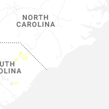
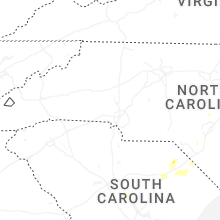
North Carolina
| Local Time | Report Details |
|---|---|
| 5:32 PM EDT | Tree reported down at 3117 norrington rd at 538 pm... estimated from radar to have occurred at 532 p in harnett county NC, 35.6 miles SSW of Raleigh, NC |
| 5:35 PM EDT | Tree reported down on mt. olive church rd. at 539 pm... estimated from radar to have occurred at 535 p in harnett county NC, 33.5 miles SSW of Raleigh, NC |
| 5:45 PM EDT | Tree fell on a house at 7146 us 401 in harnett county NC, 34.4 miles SSW of Raleigh, NC |
| 6:00 PM EDT | Corrects previous tstm wnd dmg report from 3 n hope mills. trees reported down on pala verde dr. at 608 pm... estimated from radar to have occurred at 600 p in cumberland county NC, 55.7 miles SSW of Raleigh, NC |
| 6:05 PM EDT | Corrects previous tstm wnd dmg report from 3 w vander. tree reported down on powerlines at 1733 sapona rd. at 609 pm... estimated by radar to have occurred at 605 p in cumberland county NC, 52.6 miles SSW of Raleigh, NC |
| 6:21 PM EDT | Trees down on power equipmen in harnett county NC, 35.6 miles S of Raleigh, NC |
| 6:50 PM EDT | Trees down on power equipmen in johnston county NC, 26.9 miles S of Raleigh, NC |
| 8:21 PM EDT | Thunderstorm winds blew down one tree that fell on to a power line along the 2200 block of south scales stree in rockingham county NC, 67.3 miles SSE of Roanoke, VA |
| 8:29 PM EDT | Thunderstorm winds blew down one tree on kenwick cour in rockingham county NC, 66.8 miles NW of Raleigh, NC |
| 8:39 PM EDT | Thunderstorm winds blew down one tree that fell on to a power pole along the 300 block of manley farm roa in rockingham county NC, 65.4 miles NW of Raleigh, NC |
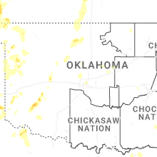
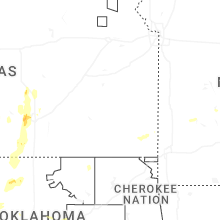
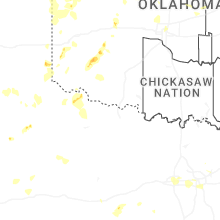
Oklahoma
| Local Time | Report Details |
|---|---|
| 4:33 PM CDT | Quarter sized hail reported near Oklahoma City, OK, 2.2 miles NNE of Oklahoma City, OK, report from mping: quarter (1.00 in.). |
| 7:18 PM CDT | Storm damage reported in grant county OK, 61.8 miles SSW of Wichita, KS |
| 7:30 PM CDT | Storm damage reported in grant county OK, 65.3 miles SSW of Wichita, KS |
| 7:46 PM CDT | Storm damage reported in garfield county OK, 76.3 miles NNW of Oklahoma City, OK |
| 7:54 PM CDT | Half Dollar sized hail reported near Kremlin, OK, 76.3 miles NNW of Oklahoma City, OK |
| 7:55 PM CDT | Light roof damage to a manufactured home along with a power pole blown down. handheld anemometer recorded a 71-mph wind gust. time estimated from rada in garfield county OK, 75 miles NNW of Oklahoma City, OK |
| 8:14 PM CDT | Quarter sized hail reported near Enid, OK, 67.4 miles NNW of Oklahoma City, OK |
| 8:34 PM CDT | Storm damage reported in kiowa county OK, 76.4 miles ENE of Childress, TX |
| 8:38 PM CDT | Em relayed 2nd hand information on 4-5 inch tree limbs down as well as corn stalks blown completely over. they estimated up to 60 mph winds with this damag in beaver county OK, 52.8 miles NW of Woodward, OK |
| 8:38 PM CDT | Quarter sized hail reported near Gate, OK, 53.2 miles NW of Woodward, OK, farmer reported hail on both sides of knowles. west side had pea sized up to nickel. east side had hail up to quarters. and it hailed about 5 minutes. |
| 8:40 PM CDT | Hobart mesone in kiowa county OK, 76.6 miles ENE of Childress, TX |
| 8:44 PM CDT | Quarter sized hail reported near Hobart, OK, 74.5 miles ENE of Childress, TX |
| 8:48 PM CDT | Ping Pong Ball sized hail reported near Hobart, OK, 75.6 miles ENE of Childress, TX, report from mping: ping pong ball (1.50 in.). |
| 9:00 PM CDT | 58 mph at 9pm. 59 is the peak so far and still another 59 mph gust at 91 in beaver county OK, 49.6 miles WNW of Woodward, OK |
| 10:00 PM CDT | Arnett mesone in ellis county OK, 36.7 miles SW of Woodward, OK |
| 10:19 PM CDT | Storm damage reported in tillman county OK, 41.5 miles NW of Wichita Falls, TX |
| 10:35 PM CDT | Storm damage reported in dewey county OK, 27.3 miles S of Woodward, OK |
| 11:05 PM CDT | Storm damage reported in ellis county OK, 36.7 miles SW of Woodward, OK |
| 11:17 PM CDT | Storm damage reported in beckham county OK, 65.8 miles NNE of Childress, TX |
| 11:19 PM CDT | Storm damage reported in beckham county OK, 69.9 miles S of Woodward, OK |
| 11:33 PM CDT | Storm damage reported in custer county OK, 67 miles SSE of Woodward, OK |
| 11:48 PM CDT | Kcs in washita county OK, 74.9 miles S of Woodward, OK |
Texas
| Local Time | Report Details |
|---|---|
| 4:30 PM MDT | Social media post of downed powerlines at ft. bliss. time approximated based on top gust at kbi in el paso county TX, 5.4 miles NE of El Paso, TX |
| 7:31 PM CDT | Storm damage reported in collingsworth county TX, 25.2 miles N of Childress, TX |
| 7:53 PM CDT | Quarter sized hail reported near Childress, TX, 17.4 miles N of Childress, TX, ground reported to be covered with hail. |
| 8:03 PM CDT | Tree blown over onto a home. time estimate in dallas county TX, 12.2 miles SSW of Dallas, TX |
| 8:15 PM CDT | Social media photo of tree damage near mayfield and collins street in arlington. several branches of 4 inch diameter snapped. time estimate in tarrant county TX, 18.8 miles WSW of Dallas, TX |
| 8:44 PM CDT | Corrects previous tstm wnd gst report from 3 w goodlet in hardeman county TX, 16.7 miles ESE of Childress, TX |
| 8:50 PM CDT | Goodlett awo in hardeman county TX, 16.7 miles ESE of Childress, TX |
| 8:55 PM CDT | Goodlett awo in hardeman county TX, 16.7 miles ESE of Childress, TX |
| 9:31 PM CDT | Storm damage reported in lipscomb county TX, 58.5 miles WSW of Woodward, OK |
| 9:32 PM CDT | Corrects previous tstm wnd gst report from comanche spring in foard county TX, 33.5 miles SSE of Childress, TX |
| 9:35 PM CDT | Storm damage reported in foard county TX, 33.5 miles SSE of Childress, TX |
| 9:55 PM CDT | Storm damage reported in foard county TX, 42.2 miles SE of Childress, TX |
| 10:00 PM CDT | Storm damage reported in foard county TX, 42.2 miles SE of Childress, TX |
| 10:15 PM CDT | Kmkn awo in comanche county TX, 75.6 miles NW of Killeen, TX |
| 10:32 PM CDT | Corrects previous tstm wnd gst report from 3 nw knox cit in knox county TX, 69.3 miles N of Abilene, TX |
| 10:35 PM CDT | Storm damage reported in knox county TX, 69.3 miles N of Abilene, TX |
| 10:40 PM CDT | Storm damage reported in knox county TX, 69.3 miles N of Abilene, TX |
| 11:00 PM CDT | Storm damage reported in foard county TX, 42.2 miles SE of Childress, TX |
| 11:03 PM CDT | Storm damage reported in haskell county TX, 62.2 miles N of Abilene, TX |
| 11:10 PM CDT | Storm damage reported in foard county TX, 42.2 miles SE of Childress, TX |
| 11:23 PM CDT | Storm damage reported in haskell county TX, 50.4 miles N of Abilene, TX |
| 11:24 PM CDT | Storm damage reported in baylor county TX, 50.1 miles WSW of Wichita Falls, TX |
| 11:30 PM CDT | Storm damage reported in baylor county TX, 50.1 miles WSW of Wichita Falls, TX |
| 11:35 PM CDT | Storm damage reported in baylor county TX, 50.1 miles WSW of Wichita Falls, TX |
| 11:40 PM CDT | Storm damage reported in baylor county TX, 50.1 miles WSW of Wichita Falls, TX |
| 11:45 PM CDT | Storm damage reported in baylor county TX, 50.1 miles WSW of Wichita Falls, TX |
| 11:51 PM CDT | Storm damage reported in jones county TX, 31.8 miles N of Abilene, TX |
| 12:54 AM CDT | Storm damage reported in carson county TX, 26.5 miles ENE of Amarillo, TX |
| 2:07 AM CDT | Per west texas mesonet 3 miles east of snyde in scurry county TX, 68.4 miles WNW of Abilene, TX |
| 2:07 AM CDT | Per west texas mesonet 3 miles southwest of snyde in scurry county TX, 73.2 miles WNW of Abilene, TX |
| 2:07 AM CDT | Trees... power lines down in snyder. a few roofs blown of in scurry county TX, 71.1 miles WNW of Abilene, TX |
Delaware
| Local Time | Report Details |
|---|---|
| 6:44 PM EDT | Tree damage reported on beaver dam rd. near laurel. time estimated from rada in sussex county DE, 30.1 miles WNW of Ocean City, MD |
| 7:25 PM EDT | One or two trees downed. time est by rada in kent county DE, 44.5 miles NNW of Ocean City, MD |
Idaho
| Local Time | Report Details |
|---|---|
| 4:50 PM MDT | Mesonet station pc371 medicine lodg in clark county ID, 61.3 miles NNW of Idaho Falls, ID |
Arizona
| Local Time | Report Details |
|---|---|
| 5:54 PM MST | Report of damage to roofing. nearby wind gust of 51 mp in pima county AZ, 10 miles E of Tucson, AZ |
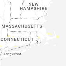
Massachusetts
| Local Time | Report Details |
|---|---|
| 12:05 AM EDT | Tree down blocking most of ardlock place near intersection with west main st in dudley. relayed by amateur radi in worcester county MA, 29.2 miles WNW of Providence, RI |
| 12:10 AM EDT | Large tree downed on perry st in douglas. relayed by amateur radi in worcester county MA, 20.2 miles NW of Providence, RI |
| 12:25 AM EDT | Tree down on wires in the area of the 200th block of purgatory road in the town of northbridg in worcester county MA, 25 miles NW of Providence, RI |
Rhode Island
| Local Time | Report Details |
|---|---|
| 12:10 AM EDT | Tree down blocking the roadway in the westbound lane of east avenue in burrillville. relayed by amateur radi in providence county RI, 16.3 miles NW of Providence, RI |
Connect with Interactive Hail Maps