

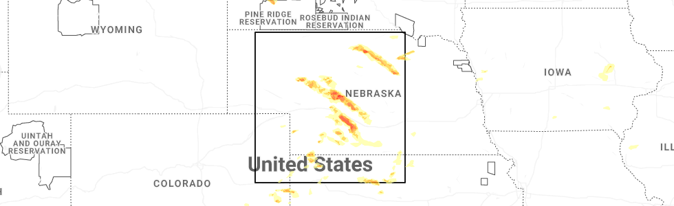
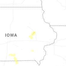
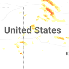
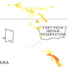
Hail Map for Saturday, July 19, 2025
Number of Impacted Households on 7/19/2025
0
Impacted by 1" or Larger Hail
0
Impacted by 1.75" or Larger Hail
0
Impacted by 2.5" or Larger Hail
Square Miles of Populated Area Impacted on 7/19/2025
0
Impacted by 1" or Larger Hail
0
Impacted by 1.75" or Larger Hail
0
Impacted by 2.5" or Larger Hail
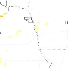
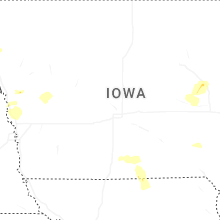
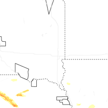
Cities Most Affected by Hail Storms of 7/19/2025
| Hail Size | Demographics of Zip Codes Affected | ||||||
|---|---|---|---|---|---|---|---|
| City | Count | Average | Largest | Pop Density | House Value | Income | Age |
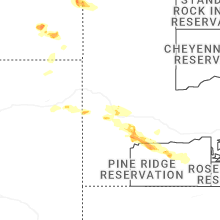
| Stapleton, NE | 5 | 2.80 | 4.00 | 1 | $53k | $33.9k | 45.0 |
| Eustis, NE | 3 | 2.33 | 3.00 | 3 | $71k | $33.2k | 49.0 |
| Sutherland, NE | 2 | 2.38 | 3.00 | 3 | $74k | $38.9k | 40.6 |
| North Platte, NE | 2 | 1.75 | 1.75 | 50 | $79k | $36.3k | 38.7 |
| Arnold, NE | 1 | 3.00 | 3.00 | 2 | $39k | $27.5k | 48.8 |
| Farnam, NE | 1 | 2.75 | 2.75 | 1 | $41k | $30.5k | 49.7 |
| Callaway, NE | 1 | 2.00 | 2.00 | 2 | $54k | $33.0k | 47.3 |
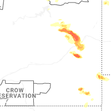
| Brockway, MT | 1 | 2.00 | 2.00 | 0 | $31k | $23.4k | 42.5 |
| Circle, MT | 1 | 2.00 | 2.00 | 0 | $43k | $28.5k | 47.1 |
| Lindsay, MT | 1 | 2.00 | 2.00 | 0 | $40k | $30.0k | 43.2 |
| Ekalaka, MT | 1 | 1.75 | 1.75 | 0 | $23k | $25.4k | 50.1 |
| Long Pine, NE | 1 | 1.75 | 1.75 | 1 | $30k | $25.2k | 44.3 |
Hail and Wind Damage Spotted on 7/19/2025
Filter by Report Type:Hail ReportsWind Reports
States Impacted
Alabama, Illinois, North Carolina, Indiana, Virginia, Nevada, Kentucky, Nebraska, Wisconsin, Montana, Kansas, Maryland, South Dakota, Ohio, California, West Virginia, North DakotaAlabama
| Local Time | Report Details |
|---|---|
| 7:03 AM CDT | Tree down across bethel circle. time estimated from rada in morgan county AL, 49.4 miles ESE of Florence, AL |
| 7:15 AM CDT | Tree down. time estimated based on rada in jackson county AL, 44.5 miles WSW of Chattanooga, TN |
| 7:33 AM CDT | Large tree down at the intersection of county rd 221 and county rd 220. time estimated from rada in jackson county AL, 50 miles WSW of Chattanooga, TN |
| 7:39 AM CDT | Tree on power line. time estimated from rada in morgan county AL, 60.3 miles ESE of Florence, AL |
| 9:31 AM CDT | Metal roof partially torn off a large barn or shed. time estimated from rada in jackson county AL, 36.3 miles SW of Chattanooga, TN |
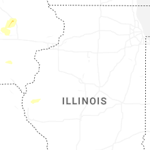
Illinois
| Local Time | Report Details |
|---|---|
| 11:54 AM CDT | Photos shared showed a few tree limbs blown down near cherry wood lane & cimarron drive and also near andrea driv in will county IL, 31.2 miles SW of Chicago, IL |
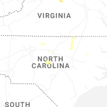
North Carolina
| Local Time | Report Details |
|---|---|
| 1:58 PM EDT | Tree downed by thunderstorm winds near the intersection of round peak church road and west pine street... and blocked the entire roa in surry county NC, 71 miles SW of Roanoke, VA |
| 2:36 PM EDT | Tree downed by thunderstorm winds on pat nixon road... and landed on a power transforme in surry county NC, 77 miles N of Charlotte, NC |
| 2:39 PM EDT | A few trees down in durham count in durham county NC, 19.9 miles NW of Raleigh, NC |
| 3:15 PM EDT | Downed tree along nc 137. time estimated by rada in gates county NC, 50.7 miles WSW of Virginia Beach, VA |
| 3:20 PM EDT | Trees on power lines resulting in power outages at us highway 1 and nc highway 9 in franklin county NC, 19.3 miles NNE of Raleigh, NC |
| 3:51 PM EDT | Trees down on power lines resulting in power outages at schley rd and nc highway 5 in orange county NC, 34.3 miles NW of Raleigh, NC |
| 4:15 PM EDT | Trees down at nc highway 43 n and temperance hall r in edgecombe county NC, 51.1 miles E of Raleigh, NC |
| 4:52 PM EDT | Trees on power lines resulting in power outages at morgan rd and nc highway 3 in vance county NC, 48.5 miles NNE of Raleigh, NC |
| 5:15 PM EDT | Tree damage reported on roanoke rapids rd. time estimated by rada in northampton county NC, 69.9 miles S of Richmond, VA |
| 7:17 PM EDT | Trees down at smith dr and nc 11 in alamance county NC, 41.9 miles WNW of Raleigh, NC |
| 7:20 PM EDT | Trees down at nc 49 and nc 11 in alamance county NC, 45.3 miles NW of Raleigh, NC |
| 7:29 PM EDT | Tree down at lannie dr and piney grove church r in orange county NC, 29.7 miles NW of Raleigh, NC |
| 7:33 PM EDT | Tree down at miller rd and meadow wind lan in orange county NC, 32.8 miles NW of Raleigh, NC |
| 8:31 PM EDT | Tree down on i-40 near exit 31 in johnston county NC, 20.4 miles SSE of Raleigh, NC |
| 8:35 PM EDT | Several hundred outages due to fallen trees on powerline in wake county NC, 15.8 miles SSW of Raleigh, NC |
| 8:50 PM EDT | Trees down along 4400 block of brogden r in johnston county NC, 30 miles SE of Raleigh, NC |
| 9:05 PM EDT | Trees down along 400 block of wc braswell r in johnston county NC, 30.9 miles SE of Raleigh, NC |
| 10:05 PM EDT | A few hundred power outages due to trees on powerline in wayne county NC, 49.9 miles ESE of Raleigh, NC |
Indiana
| Local Time | Report Details |
|---|---|
| 2:08 PM CDT | Tree down blocking the right lane of veterans memorial parkway. time estimated from rada in vanderburgh county IN, 1.2 miles SSW of Evansville, IN |
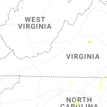
Virginia
| Local Time | Report Details |
|---|---|
| 3:16 PM EDT | Three trees down near scottsville on james river roa in albemarle county VA, 50.3 miles WNW of Richmond, VA |
| 3:19 PM EDT | 3 trees down across the town of scottsville. relayed from albemarle county. time estimated from rada in fluvanna county VA, 50.3 miles WNW of Richmond, VA |
| 3:20 PM EDT | Multiple trees knocked down along w river rd. time estimated from rada in fluvanna county VA, 49.8 miles WNW of Richmond, VA |
| 3:21 PM EDT | Trees down on proffit road and proffit station roa in albemarle county VA, 60.6 miles NW of Richmond, VA |
| 4:08 PM EDT | Tree downed by thunderstorm winds on irisburg road... and blocked one lan in henry county VA, 47.1 miles SSE of Roanoke, VA |
| 5:15 PM EDT | Tree down across the road blocking traffic. time estimated by rada in brunswick county VA, 64.4 miles NNE of Raleigh, NC |
| 5:21 PM EDT | Tree down across the road blocking all lanes. time estimated by rada in brunswick county VA, 66.3 miles SSW of Richmond, VA |
| 5:29 PM EDT | Tree reported down across alvis rd. time estimated by rada in brunswick county VA, 64.2 miles SSW of Richmond, VA |
| 5:30 PM EDT | Tree reported down across tillman rd. time estimated by rada in brunswick county VA, 64.7 miles SSW of Richmond, VA |
| 5:30 PM EDT | Tree reported down at the intersection of huckstep rd. and robinson ferry rd. time estimated by rada in brunswick county VA, 63.8 miles SSW of Richmond, VA |
| 5:31 PM EDT | Tree reported down across shining creek rd. time estimated by rada in brunswick county VA, 50.7 miles SSW of Richmond, VA |
| 5:32 PM EDT | Tree reported down across brunswick dr. time estimated by rada in brunswick county VA, 50.8 miles SSW of Richmond, VA |
| 6:21 PM EDT | Corrects previous tstm wnd dmg report from 2 nw meredithville. tree reported down across shining creek rd. time estimated by rada in brunswick county VA, 50.7 miles SSW of Richmond, VA |
| 6:23 PM EDT | Corrects previous tstm wnd dmg report from 1 n meredithville. tree reported down across brunswick dr. time estimated by rada in brunswick county VA, 50.8 miles SSW of Richmond, VA |
| 6:34 PM EDT | Tree down along old white oak r in dinwiddie county VA, 30.3 miles S of Richmond, VA |
| 6:40 PM EDT | Tree down along nash r in dinwiddie county VA, 29.9 miles S of Richmond, VA |
| 6:52 PM EDT | Tree down along river rd in goochland county VA, 11.6 miles NW of Richmond, VA |
| 6:56 PM EDT | Tree down along manakin r in goochland county VA, 13.3 miles NNW of Richmond, VA |
| 6:56 PM EDT | Tree down along 656 rockford r in goochland county VA, 13.4 miles NNW of Richmond, VA |
| 6:58 PM EDT | Tree down along millers l in goochland county VA, 10.3 miles NNW of Richmond, VA |
| 6:58 PM EDT | A large tree down along hermitage r in goochland county VA, 11 miles N of Richmond, VA |
| 6:58 PM EDT | Power line wires down along millers l in goochland county VA, 10.9 miles NNW of Richmond, VA |
| 6:58 PM EDT | 2 reports of trees blocking portions of i-64 in eastern goochland county. time estimated from rada in goochland county VA, 13.1 miles NNW of Richmond, VA |
| 7:00 PM EDT | Tree down along st matthews l in goochland county VA, 12.3 miles N of Richmond, VA |
| 7:00 PM EDT | Tree knocked down blocking ashland rd. near three chopt rd. time estimated from rada in goochland county VA, 12.2 miles N of Richmond, VA |
| 7:01 PM EDT | Power line wires down along broad street r in goochland county VA, 11.5 miles N of Richmond, VA |
| 7:05 PM EDT | Numerous trees down along twin hickory lake d in henrico county VA, 11.1 miles NNE of Richmond, VA |
| 7:08 PM EDT | Tree fell on car on cauthorne rd. no injuries were reported. time estimated by rada in hanover county VA, 15.2 miles N of Richmond, VA |
| 7:09 PM EDT | Tree down on howards mill road. time estimated by rada in hanover county VA, 16.3 miles N of Richmond, VA |
| 7:09 PM EDT | Numerous trees reported down along ashland rd. time estimated by rada in hanover county VA, 15 miles N of Richmond, VA |
| 7:10 PM EDT | Numerous trees down across broad stree in henrico county VA, 10.4 miles NNE of Richmond, VA |
| 7:10 PM EDT | Numerous trees down along staples mill r in henrico county VA, 13.3 miles NNE of Richmond, VA |
| 7:11 PM EDT | Tree reported down on mountain rd. tim estimated by rada in henrico county VA, 14.2 miles NE of Richmond, VA |
| 7:14 PM EDT | Tree down on i-95 via waze and traffic camer in city of petersburg county VA, 24 miles SSE of Richmond, VA |
| 7:43 PM EDT | Numerous trees down across king william count in king william county VA, 35.7 miles NE of Richmond, VA |
| 7:53 PM EDT | Tree down on va-155 in the county of charles city... in the vicinity of kenthill ln; county/city/town line: new kent county line/charles city county lin in charles city county VA, 34.2 miles E of Richmond, VA |
| 7:59 PM EDT | 3 trees have fallen across the eastern portion of the count in new kent county VA, 45.7 miles E of Richmond, VA |
| 7:59 PM EDT | A powerline fell due to thunderstorm win in new kent county VA, 45.1 miles E of Richmond, VA |
| 8:01 PM EDT | A large tree down on on rt. 632 in the county of king william... in the vicinity of smith ferry rd; rt. 630n/s (king william county in king william county VA, 38.9 miles E of Richmond, VA |
| 8:19 PM EDT | Tree down at the intersection of old virginia street and warner r in middlesex county VA, 58 miles E of Richmond, VA |
| 8:19 PM EDT | Tree down at the intersection of town bridge rd and old virginia stree in middlesex county VA, 59 miles E of Richmond, VA |
| 8:30 PM EDT | Report of a tree down on tucker hill road. time estimated via rada in westmoreland county VA, 70.5 miles NE of Richmond, VA |
| 8:34 PM EDT | Numerous trees down across lancaster count in lancaster county VA, 67.3 miles ENE of Richmond, VA |
| 8:44 PM EDT | Tree down along sydnors millpond r in northumberland county VA, 74.1 miles ENE of Richmond, VA |
| 8:44 PM EDT | Trees down at the intersection of dodlyt rd and northumberland hw in northumberland county VA, 70.3 miles ENE of Richmond, VA |
| 8:45 PM EDT | Tree down along lottsburg r in northumberland county VA, 69.7 miles ENE of Richmond, VA |
| 9:38 PM EDT | Tree downed by thunderstorm winds and blocking both lanes of iron bridge road... about a mile and a half from route 5 in patrick county VA, 35.4 miles SSW of Roanoke, VA |
| 10:20 PM EDT | Tree downed by thunderstorm winds near the intersection of meadowood trail and preston road... and blocked the entire roadwa in henry county VA, 43.6 miles S of Roanoke, VA |
Nevada
| Local Time | Report Details |
|---|---|
| 1:30 PM PDT | Mesonet station a18aa 26.2 ne beatty (arl sord). accompanied by 0.73 inches of rainfall in the hou in nye county NV, 97.2 miles NW of Las Vegas, NV |
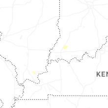
Kentucky
| Local Time | Report Details |
|---|---|
| 3:35 PM CDT | Tree downed by thunderstorm winds on madison st south of neb in hopkins county KY, 43.5 miles S of Evansville, IN |
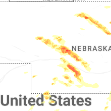
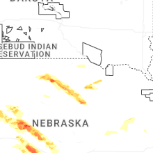
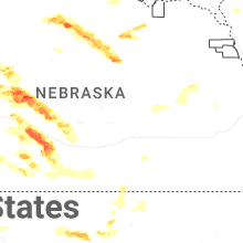
Nebraska
| Local Time | Report Details |
|---|---|
| 3:36 PM CDT | Golf Ball sized hail reported near Stapleton, NE, 25 miles NNE of North Platte, NE, golf ball size hail... possibly larger reported by coop observer. |
| 3:41 PM CDT | Baseball sized hail reported near Stapleton, NE, 25 miles NNE of North Platte, NE, baseball size hail reported from coop observer. |
| 4:11 PM CDT | Baseball sized hail reported near Stapleton, NE, 18.7 miles NE of North Platte, NE, report from mping: baseball (2.75 in.). |
| 4:13 PM CDT | Grapefruit sized hail reported near Stapleton, NE, 20 miles NE of North Platte, NE, report from mping: grapefruit (4.00 in.). |
| 4:28 PM CDT | Quarter sized hail reported near Verdigre, NE, 25.2 miles E of Oneill, NE |
| 4:37 PM CDT | Baseball sized hail reported near Stapleton, NE, 22.9 miles NE of North Platte, NE, had reports of hail breaking out windows on several houses in town. there was some water over the county roads. |
| 4:48 PM CDT | Golf Ball sized hail reported near Sutherland, NE, 37.7 miles NW of North Platte, NE |
| 4:55 PM CDT | Tea Cup sized hail reported near Sutherland, NE, 36.2 miles NW of North Platte, NE |
| 5:02 PM CDT | Tea Cup sized hail reported near Arnold, NE, 30.6 miles ENE of North Platte, NE |
| 5:16 PM CDT | Quarter sized hail reported near North Platte, NE, 1.5 miles WSW of North Platte, NE |
| 5:17 PM CDT | Quarter sized hail reported near North Platte, NE, 1 miles NNW of North Platte, NE |
| 5:17 PM CDT | Golf Ball sized hail reported near North Platte, NE, 1.6 miles N of North Platte, NE |
| 5:18 PM CDT | Golf Ball sized hail reported near North Platte, NE, 3.3 miles E of North Platte, NE |
| 5:20 PM CDT | Half Dollar sized hail reported near Long Pine, NE, 49.4 miles ESE of Valentine, NE |
| 5:22 PM CDT | Ping Pong Ball sized hail reported near Ainsworth, NE, 46.1 miles ESE of Valentine, NE, ping pong size hail and 50 mph winds. |
| 5:22 PM CDT | Golf Ball sized hail reported near Long Pine, NE, 49.7 miles ESE of Valentine, NE |
| 5:33 PM CDT | Hen Egg sized hail reported near Callaway, NE, 40.9 miles E of North Platte, NE, delayed report via social media. time estimated by radar. |
| 5:52 PM CDT | Quarter sized hail reported near Maxwell, NE, 13.3 miles ESE of North Platte, NE, delayed report via social media. time estimated by radar. |
| 6:11 PM CDT | Quarter sized hail reported near Farnam, NE, 25.4 miles SE of North Platte, NE, delayed report via social media. time estimated by radar. |
| 6:33 PM CDT | Report of tree branches knocked down onto a vehicl in dawson county NE, 40.9 miles SE of North Platte, NE |
| 6:40 PM CDT | Baseball sized hail reported near Farnam, NE, 40.1 miles SE of North Platte, NE, spotter network reports baseball sized hail northeast of farnam. |
| 6:41 PM CDT | Quarter sized hail reported near Lexington, NE, 61.7 miles ESE of North Platte, NE, report from mping: quarter (1.00 in.). |
| 6:52 PM CDT | Golf Ball sized hail reported near Eustis, NE, 50.1 miles SE of North Platte, NE |
| 6:55 PM CDT | Hen Egg sized hail reported near Eustis, NE, 48.4 miles SE of North Platte, NE, had large hail between 650 to 7pm ct with heavy rainfall. |
| 6:55 PM CDT | Tea Cup sized hail reported near Eustis, NE, 50.5 miles SE of North Platte, NE, time estimated by radar. |
| 7:04 PM CDT | Quarter sized hail reported near Hayes Center, NE, 44.8 miles SSW of North Platte, NE |
| 7:30 PM CDT | Off-duty nws employee estimates 60mph wind gusts in arapaho in furnas county NE, 73.2 miles SE of North Platte, NE |
| 8:00 PM CDT | Video on social media of a large tree limb on the ground in oxford. time estimated from rada in harlan county NE, 80.5 miles SW of Grand Island, NE |
| 8:10 PM CDT | Personal weather station reports gust to 72mp in harlan county NE, 80.2 miles SW of Grand Island, NE |
| 8:14 PM CDT | Site timmerman house measures 62 mph wind gus in red willow county NE, 63.7 miles SSE of North Platte, NE |
| 8:20 PM CDT | Trained spotter estimates 50-60 mph wind gust in red willow county NE, 64.6 miles SSE of North Platte, NE |
| 8:31 PM CDT | Personal weather station reports gust to 59mp in harlan county NE, 72.6 miles SW of Grand Island, NE |
| 8:35 PM CDT | Personal weather station reports gust to 62mp in harlan county NE, 71 miles SW of Grand Island, NE |
| 8:50 PM CDT | Personal weather station reports gust to 62mp in harlan county NE, 62.9 miles SW of Grand Island, NE |
Wisconsin
| Local Time | Report Details |
|---|---|
| 4:28 PM CDT | Large pine tree down... several small-medium branches down... and damage to roofing. video taken from public... relayed by medi in manitowoc county WI, 28.4 miles SSE of Green Bay, WI |
Montana
| Local Time | Report Details |
|---|---|
| 4:15 PM MDT | Mesonet station mtbid 6.2 s biddle (mt dot in powder river county MT, 49.9 miles N of Gillette, WY |
| 4:53 PM MDT | Ping Pong Ball sized hail reported near Brockway, MT, 59.6 miles N of Miles City, MT, truck window broken due to the hail. |
| 5:15 PM MDT | Hen Egg sized hail reported near Circle, MT, 65.7 miles N of Miles City, MT |
| 5:20 PM MDT | Hen Egg sized hail reported near Brockway, MT, 59.6 miles N of Miles City, MT, windshield cracked. |
| 5:55 PM MDT | Hen Egg sized hail reported near Lindsay, MT, 58.6 miles NNE of Miles City, MT |
| 6:30 PM MDT | Blm terry statio in prairie county MT, 41 miles NE of Miles City, MT |
| 6:42 PM MDT | Winds estimated to be in excess of 60 mph based on social media video post and tree limb damag in prairie county MT, 36.9 miles NE of Miles City, MT |
| 7:00 PM MDT | Emergency management reported branches down from multiple trees across town... a main power line down causing power outage in terry. damage to a tin roof at ball fiel in prairie county MT, 36.9 miles NE of Miles City, MT |
| 8:15 PM MDT | Storm damage reported in custer county MT, 37.9 miles E of Miles City, MT |
| 9:32 PM MDT | Storm damage reported in fallon county MT, 90 miles ESE of Miles City, MT |
| 9:38 PM MDT | Golf Ball sized hail reported near Ekalaka, MT, 89.2 miles ESE of Miles City, MT, mostly peas with a few golf balls. |
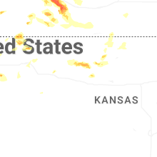
Kansas
| Local Time | Report Details |
|---|---|
| 5:59 PM CDT | Delayed entry. site black_tub_ranch measured 60 mph wind gus in dundy county NE, 47.4 miles NNW of Colby, KS |
| 6:50 PM CDT | Quarter sized hail reported near Colby, KS, 1.9 miles S of Colby, KS, sporadic quarter sized hail. |
| 7:01 PM CDT | Lots of pea size hail and torrential rainfall occurring as wel in thomas county KS, 8.1 miles ENE of Colby, KS |
| 9:32 PM CDT | Personal weather station reports gust to 59mp in rooks county KS, 36.1 miles NNW of Hays, KS |
| 9:57 PM CDT | Emergency manager reports broken power poles off hwy 183 and s road. time estimated from rada in rooks county KS, 30.3 miles N of Hays, KS |
| 10:00 PM CDT | Ping Pong Ball sized hail reported near Plainville, KS, 26.9 miles N of Hays, KS, emergency manager reports ping-pong ball sized hail north of plainville. |
| 10:19 PM CDT | Site ks-russellsprings3sw measures 64 mph wind gus in logan county KS, 36.9 miles SSW of Colby, KS |
| 10:23 PM CDT | Mesonet station up840 9.0 w winona (upr in logan county KS, 33.1 miles SW of Colby, KS |
| 10:24 PM CDT | Site section_17 (awn) measured 87 mph wind gus in logan county KS, 35.1 miles SW of Colby, KS |
| 10:27 PM CDT | Site ks_russellsprings3sw measured 64 mph wind gus in logan county KS, 36.9 miles SSW of Colby, KS |
| 10:28 PM CDT | Mesonet station up840 9.0 w winona (upr in logan county KS, 33.1 miles SW of Colby, KS |
| 10:39 PM CDT | Site jake_from_the_farm measured 60 mph wind gus in logan county KS, 23 miles SSW of Colby, KS |
| 10:40 PM CDT | Site kksmonum6 reports 64 mph wind gus in logan county KS, 26.6 miles SSW of Colby, KS |
| 11:05 PM CDT | Site k5ok7 measured 63 mph wind gus in gove county KS, 23.8 miles SSE of Colby, KS |
| 11:05 PM CDT | Dispatch relayed report of two semis blown over on i-70. time estimated from first called in report. location approximate in gove county KS, 22.9 miles SSE of Colby, KS |
| 12:42 AM CDT | Asos station khlc hill cit in graham county KS, 43.6 miles NW of Hays, KS |
Maryland
| Local Time | Report Details |
|---|---|
| 8:18 PM EDT | Storm damage reported in anz533 county MD, 62.6 miles S of Baltimore, MD |
South Dakota
| Local Time | Report Details |
|---|---|
| 6:48 PM MDT | Quarter sized hail reported near Lead, SD, 40.6 miles WNW of Rapid City, SD, a few of the larger pieces were 1 inch in diameter... most was smaller. |
| 7:24 PM MDT | Quarter sized hail reported near Black Hawk, SD, 7.6 miles NW of Rapid City, SD |
| 7:40 PM MDT | 3/4 inch hail in meade county SD, 5.4 miles N of Rapid City, SD |
| 7:45 PM MDT | Quarter sized hail reported near Rapid City, SD, 3.4 miles N of Rapid City, SD |
| 7:53 PM MDT | Storm damage reported in meade county SD, 8.5 miles NE of Rapid City, SD |
| 7:53 PM MDT | Storm damage reported in pennington county SD, 9.3 miles ESE of Rapid City, SD |
| 7:55 PM MDT | Quarter sized hail reported near Rapid City, SD, 16 miles W of Rapid City, SD |
| 7:58 PM MDT | Storm damage reported in pennington county SD, 7.5 miles ENE of Rapid City, SD |
| 8:02 PM MDT | 69.6 mph in pennington county SD, 3.9 miles NNE of Rapid City, SD |
| 8:25 PM MDT | Quarter sized hail reported near Rapid City, SD, 7 miles SW of Rapid City, SD, nickel to quarter |
| 8:26 PM MDT | Quarter sized hail reported near Rapid City, SD, 5.1 miles SW of Rapid City, SD |
| 8:30 PM MDT | Quarter sized hail reported near Rapid City, SD, 4.2 miles S of Rapid City, SD |
| 9:25 PM MDT | Storm damage reported in custer county SD, 28.2 miles SSE of Rapid City, SD |
| 11:56 PM MDT | Storm damage reported in jackson county SD, 69.1 miles NW of Valentine, NE |
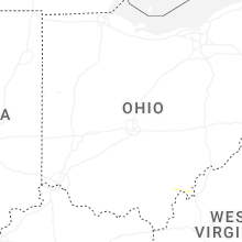
Ohio
| Local Time | Report Details |
|---|---|
| 9:15 PM EDT | Damage to crops near lochard road and wells road intersection. possible tornado. time estimated from rada in shelby county OH, 66.7 miles WNW of Columbus, OH |
| 9:36 PM EDT | Corrects previous tstm wnd dmg report from 3 ese tremont city. trees and power lines down at moorefield and west ridgewood. two buildings damaged as well. possible torn in clark county OH, 41.3 miles W of Columbus, OH |
California
| Local Time | Report Details |
|---|---|
| 6:42 PM PDT | Mesonet station idpc1 independence 4 wn in inyo county CA, 84.4 miles E of Fresno, CA |
West Virginia
| Local Time | Report Details |
|---|---|
| 11:03 PM EDT | Tree down near justic in mingo county WV, 53.6 miles SSW of Charleston, WV |
North Dakota
| Local Time | Report Details |
|---|---|
| 11:33 PM CDT | Ndawn station grenora 8 in divide county ND, 42.7 miles NNW of Williston, ND |
Connect with Interactive Hail Maps