

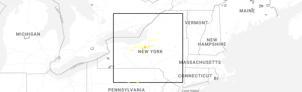
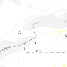
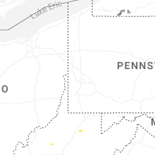
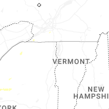
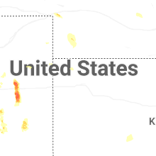
Hail Map for Sunday, August 24, 2025
Number of Impacted Households on 8/24/2025
0
Impacted by 1" or Larger Hail
0
Impacted by 1.75" or Larger Hail
0
Impacted by 2.5" or Larger Hail
Square Miles of Populated Area Impacted on 8/24/2025
0
Impacted by 1" or Larger Hail
0
Impacted by 1.75" or Larger Hail
0
Impacted by 2.5" or Larger Hail
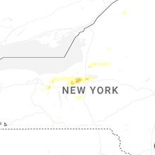
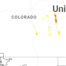

Cities Most Affected by Hail Storms of 8/24/2025
| Hail Size | Demographics of Zip Codes Affected | ||||||
|---|---|---|---|---|---|---|---|
| City | Count | Average | Largest | Pop Density | House Value | Income | Age |
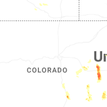
| Arriba, CO | 2 | 1.75 | 1.75 | 1 | $56k | $26.9k | 49.1 |
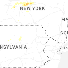
| Baldwinsville, NY | 1 | 1.75 | 1.75 | 484 | $91k | $51.7k | 42.1 |
Hail and Wind Damage Spotted on 8/24/2025
Filter by Report Type:Hail ReportsWind Reports
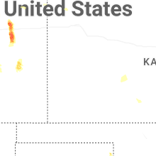
States Impacted
New York, Kansas, Colorado, Nevada, Arizona, California, Oklahoma, Pennsylvania, West Virginia, Utah, TexasNew York
| Local Time | Report Details |
|---|---|
| 1:38 PM EDT | Report of 2 trees down in palermo. time estimated from rada in oswego county NY, 22.4 miles NNW of Syracuse, NY |
| 2:04 PM EDT | Report of half of a tree and wires down across state route 44 in ontario county NY, 65.3 miles W of Syracuse, NY |
| 2:08 PM EDT | Tree down blocking half of the roa in ontario county NY, 62 miles W of Syracuse, NY |
| 2:09 PM EDT | Tree down partially blocking oakmount roa in ontario county NY, 66 miles WSW of Syracuse, NY |
| 2:09 PM EDT | Report of 2 trees down in the town of ira. time estimated from rada in cayuga county NY, 23.5 miles WNW of Syracuse, NY |
| 2:11 PM EDT | Quarter sized hail reported near Cato, NY, 22.9 miles WNW of Syracuse, NY, image sent with hail and tape measure. time estimated from radar. |
| 2:11 PM EDT | Half Dollar sized hail reported near Cato, NY, 22.9 miles WNW of Syracuse, NY, estimated hail size from picture. time estimated from radar. |
| 2:15 PM EDT | Tree fell into roadwa in ontario county NY, 58.7 miles W of Syracuse, NY |
| 2:35 PM EDT | Multiple trees down in the town of acadia. time estimated from rada in wayne county NY, 47.8 miles W of Syracuse, NY |
| 2:52 PM EDT | Trees down in sodus. time estimated from rada in wayne county NY, 48 miles WNW of Syracuse, NY |
| 2:57 PM EDT | Reports of multiple trees down in savannah. time estimated from rada in wayne county NY, 31 miles W of Syracuse, NY |
| 3:10 PM EDT | Several trees down in port byron. time estimated from rada in cayuga county NY, 24 miles W of Syracuse, NY |
| 3:17 PM EDT | Several trees down in weedsport. time estimated from rada in cayuga county NY, 20.9 miles W of Syracuse, NY |
| 3:21 PM EDT | Several trees down in cato. time estimated from rada in cayuga county NY, 22.9 miles WNW of Syracuse, NY |
| 3:33 PM EDT | Quarter sized hail reported near Jordan, NY, 16.4 miles W of Syracuse, NY |
| 3:33 PM EDT | Trees and wires dow in onondaga county NY, 16.4 miles W of Syracuse, NY |
| 3:33 PM EDT | Golf Ball sized hail reported near Baldwinsville, NY, 17.4 miles WNW of Syracuse, NY, report on social media of golf ball sized hail near lysander. |
| 3:34 PM EDT | Tree down on wire in onondaga county NY, 16.2 miles WNW of Syracuse, NY |
| 3:37 PM EDT | Photos of large tree branches down heading toward jordan via social medi in onondaga county NY, 16.4 miles W of Syracuse, NY |
| 3:40 PM EDT | Tree down on wire in onondaga county NY, 13.5 miles W of Syracuse, NY |
| 3:46 PM EDT | Ping Pong Ball sized hail reported near Baldwinsville, NY, 12 miles NW of Syracuse, NY, hail size estimated from picture. |
| 3:46 PM EDT | Half Dollar sized hail reported near Warners, NY, 9.5 miles WNW of Syracuse, NY, picture on social media of several quarter to half dollar sized hail stones along with a quarter for comparison. |
| 3:50 PM EDT | Tree down on wire in onondaga county NY, 6.2 miles W of Syracuse, NY |
| 3:54 PM EDT | A tent collapsed outside of gate 4 of the great new york state fair and brought down a utility wire onto sate fair boulevard. an awning of another stand was damaged as in onondaga county NY, 4.2 miles WNW of Syracuse, NY |
| 3:56 PM EDT | Quarter sized hail reported near Syracuse, NY, 5.4 miles WNW of Syracuse, NY, report from social media. |
| 3:56 PM EDT | Quarter sized hail reported near Syracuse, NY, 6.2 miles WNW of Syracuse, NY |
| 4:01 PM EDT | Picture on social media of a tree down on a hous in onondaga county NY, 3.5 miles N of Syracuse, NY |
| 4:01 PM EDT | Quarter sized hail reported near Liverpool, NY, 4.4 miles NW of Syracuse, NY, photo on social media of quarter-sized hail in salina/liverpool. |
| 5:11 PM EDT | Tree down blocking butternut ridge r in st. lawrence county NY, 25.7 miles ESE of Ogdensburg, NY |
| 5:16 PM EDT | Power lines down with tree on house on church s in st. lawrence county NY, 26.3 miles ESE of Ogdensburg, NY |
| 5:16 PM EDT | Tree and power lines down on pumpkin hill roa in st. lawrence county NY, 26.6 miles E of Ogdensburg, NY |
| 5:18 PM EDT | Multiple trees down on west parishville roa in st. lawrence county NY, 27.1 miles E of Ogdensburg, NY |
| 5:25 PM EDT | Tree and power lines down on highway 11 in st. lawrence county NY, 28.6 miles E of Ogdensburg, NY |
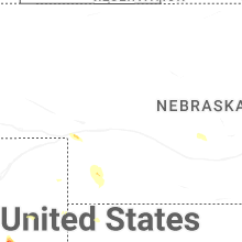
Kansas
| Local Time | Report Details |
|---|---|
| 2:14 PM CDT | Storm damage reported in hodgeman county KS, 62.3 miles SSW of Hays, KS |
| 2:29 PM CDT | Storm damage reported in hodgeman county KS, 62.4 miles E of Garden City, KS |
Colorado
| Local Time | Report Details |
|---|---|
| 2:12 PM MDT | Golf Ball sized hail reported near Arriba, CO, 55.5 miles SSW of Yuma, CO |
| 2:38 PM MDT | Golf Ball sized hail reported near Arriba, CO, 62.3 miles SSW of Yuma, CO |
| 2:45 PM MDT | Quarter sized hail reported near Colorado Springs, CO, 38.9 miles N of Pueblo, CO |
| 3:07 PM MDT | Measured gust at fort carson (kfcs in el paso county CO, 29.8 miles NNW of Pueblo, CO |
| 7:38 PM MDT | Asos station klic limo in lincoln county CO, 77.3 miles SW of Yuma, CO |
Nevada
| Local Time | Report Details |
|---|---|
| 1:45 PM PDT | Boulder island observed a gust to 59 mph at 1345 followed by a peak gust to 64 mph by 140 in clark county NV, 23.4 miles ESE of Las Vegas, NV |
| 4:57 PM PDT | Asos tonopah airport (ktph)... elevation 5426 fee in nye county NV, 144.2 miles SW of Ely, NV |
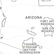
Arizona
| Local Time | Report Details |
|---|---|
| 2:26 PM MST | Aps utility company had damage to equipment due to strong thunderstorm winds causing loss of power to 56 customers from the international border to puerto blanco r in pima county AZ, 109.4 miles W of Tucson, AZ |
California
| Local Time | Report Details |
|---|---|
| 3:50 PM PDT | Pole down//blocking both lanes on brockman time estimated based on rada in imperial county CA, 59.2 miles W of Yuma, AZ |
| 3:55 PM PDT | Power lines downed across roadway. time estimated based on rada in imperial county CA, 62 miles W of Yuma, AZ |
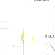
Oklahoma
| Local Time | Report Details |
|---|---|
| 6:25 PM CDT | Storm damage reported in dewey county OK, 27.3 miles S of Woodward, OK |
| 6:30 PM CDT | Storm damage reported in dewey county OK, 27.2 miles S of Woodward, OK |
| 6:35 PM CDT | Storm damage reported in dewey county OK, 27.3 miles S of Woodward, OK |
| 8:00 PM CDT | Storm damage reported in washita county OK, 73.2 miles SSE of Woodward, OK |
Pennsylvania
| Local Time | Report Details |
|---|---|
| 7:30 PM EDT | Large tree down across hoods mill road blocking the entire roadway. time estimated via rada in westmoreland county PA, 38.3 miles ESE of Pittsburgh, PA |
| 7:30 PM EDT | Tree down along old distillery road at foggy mountain lodge. time estimated via rada in westmoreland county PA, 38.9 miles ESE of Pittsburgh, PA |
| 7:32 PM EDT | Tree down across the road at intersection of hoods mill road and bethel church road. time estimated via rada in westmoreland county PA, 38.7 miles ESE of Pittsburgh, PA |
| 7:35 PM EDT | Trees down across the road at the area of rector run road and tall tree lane. time estimated via rada in westmoreland county PA, 42.3 miles ESE of Pittsburgh, PA |
| 7:36 PM EDT | Tree down across route 381 at old linn run road. time estimated via rada in westmoreland county PA, 43.3 miles ESE of Pittsburgh, PA |
West Virginia
| Local Time | Report Details |
|---|---|
| 8:14 PM EDT | Tree damage resulting in 619 customers without powe in calhoun county WV, 54 miles NNE of Charleston, WV |
| 8:16 PM EDT | Several trees down... some blocking roadway... in several spots along north calhoun highway. time and location estimated from rada in calhoun county WV, 52.4 miles NE of Charleston, WV |
| 9:30 PM EDT | Tree down partially blocking roadway near fairmont rd and hagans rd. time estimated based off rada in monongalia county WV, 47.3 miles NNW of Elkins, WV |
| 9:50 PM EDT | Trees and power lines down blocking the road near kingwood pike and cobun creek rd. time estimated based off rada in monongalia county WV, 46.2 miles N of Elkins, WV |
| 9:52 PM EDT | Tree and power lines down blocking the roadway. time estimated based off rada in monongalia county WV, 46.7 miles N of Elkins, WV |
| 10:16 PM EDT | Tree down blocking one lane on route 119 in volga. time estimated from rada in barbour county WV, 17.9 miles NW of Elkins, WV |
| 10:16 PM EDT | Tree reported dow in barbour county WV, 18.7 miles NW of Elkins, WV |
| 10:20 PM EDT | Couple of lines reported dow in barbour county WV, 19 miles NW of Elkins, WV |
| 10:20 PM EDT | Top of maple tree snapped off and blocking one lane of buckhannon roa in barbour county WV, 18.5 miles NW of Elkins, WV |
| 10:41 PM EDT | Tree down blocking wb lane along west state ave by the mountaineer mart. time estimated based off rada in preston county WV, 39.6 miles NNE of Elkins, WV |
| 10:45 PM EDT | Tree down on hanger road in belingto in barbour county WV, 12.4 miles NW of Elkins, WV |
Utah
| Local Time | Report Details |
|---|---|
| 8:00 PM MDT | Mesonet recorded wind gust of 59 mph at callao sensor (dpg20 in tooele county UT, 80.1 miles NE of Ely, NV |
| 8:10 PM MDT | Mesonet recorded gust of 87 mph at the causeway sensor (dpg18 in tooele county UT, 94.4 miles NE of Ely, NV |
| 8:50 PM MDT | Mesonet recorded wind gust of 59 mph at the horizontal grid sensor (dpg08 in tooele county UT, 77.8 miles WSW of Salt Lake City, UT |
| 9:05 PM MDT | Mesonet recorded wind gust of 63 mph at the playa station sensor (dpg09 in tooele county UT, 77.8 miles WSW of Salt Lake City, UT |
| 9:05 PM MDT | Mesonet recorded wind gust of 65 mph at the target s sensor (dpg04 in tooele county UT, 78.4 miles SW of Salt Lake City, UT |
| 9:15 PM MDT | Mesonet recorded wind gust of 62 mph at the simpson springs sensor (dpg21 in tooele county UT, 80.2 miles SW of Salt Lake City, UT |
Texas
| Local Time | Report Details |
|---|---|
| 9:23 PM CDT | A few intermittent wind gusts occurred at around 60 mph in the 15 minutes before the 82 mph wind gust occurre in gray county TX, 52.9 miles E of Amarillo, TX |
Connect with Interactive Hail Maps