

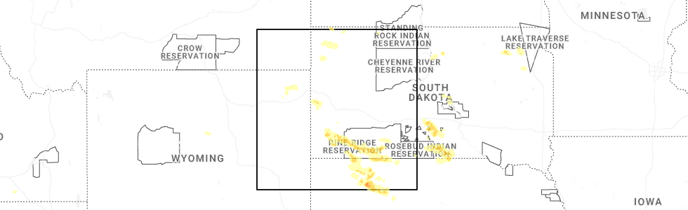
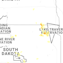
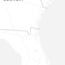
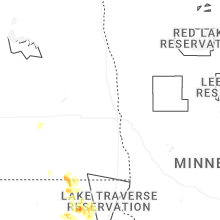
Hail Map for Wednesday, August 13, 2025
Number of Impacted Households on 8/13/2025
0
Impacted by 1" or Larger Hail
0
Impacted by 1.75" or Larger Hail
0
Impacted by 2.5" or Larger Hail
Square Miles of Populated Area Impacted on 8/13/2025
0
Impacted by 1" or Larger Hail
0
Impacted by 1.75" or Larger Hail
0
Impacted by 2.5" or Larger Hail
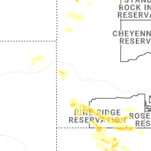
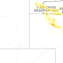
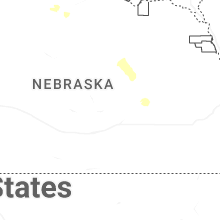
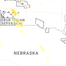


Cities Most Affected by Hail Storms of 8/13/2025
| Hail Size | Demographics of Zip Codes Affected | ||||||
|---|---|---|---|---|---|---|---|
| City | Count | Average | Largest | Pop Density | House Value | Income | Age |
| Lakeside, NE | 1 | 1.75 | 1.75 | 0 | $33k | $30.8k | 39.9 |
Hail and Wind Damage Spotted on 8/13/2025
Filter by Report Type:Hail ReportsWind Reports
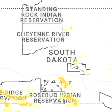
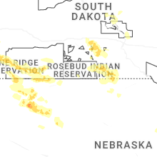
States Impacted
South Dakota, Montana, New York, Connecticut, Vermont, Idaho, West Virginia, Wyoming, Massachusetts, Maine, New Hampshire, Virginia, New Jersey, Florida, South Carolina, Nebraska, North Dakota, NevadaSouth Dakota
| Local Time | Report Details |
|---|---|
| 9:38 AM CDT | Quarter sized hail reported near Java, SD, 70.8 miles W of Aberdeen, SD, nickel to quarter sized hail. |
| 4:14 PM MDT | Storm damage reported in fall river county SD, 66.9 miles SW of Rapid City, SD |
| 4:15 PM MDT | Time estimated based on radar in lawrence county SD, 39.2 miles NW of Rapid City, SD |
| 4:24 PM MDT | Storm damage reported in butte county SD, 61.7 miles NNW of Rapid City, SD |
| 4:24 PM MDT | Storm damage reported in fall river county SD, 66.9 miles SW of Rapid City, SD |
| 4:27 PM MDT | Storm damage reported in custer county SD, 35.2 miles SW of Rapid City, SD |
| 4:30 PM MDT | Storm damage reported in butte county SD, 44.4 miles NNW of Rapid City, SD |
| 4:35 PM MDT | Storm damage reported in meade county SD, 24.5 miles NNW of Rapid City, SD |
| 4:38 PM MDT | Storm damage reported in meade county SD, 13 miles NW of Rapid City, SD |
| 4:52 PM MDT | Storm damage reported in meade county SD, 8.5 miles NE of Rapid City, SD |
| 4:55 PM MDT | Storm damage reported in harding county SD, 87 miles N of Rapid City, SD |
| 4:58 PM MDT | Storm damage reported in meade county SD, 8.5 miles NE of Rapid City, SD |
| 4:59 PM MDT | Storm damage reported in pennington county SD, 7.5 miles ENE of Rapid City, SD |
| 5:00 PM MDT | Storm damage reported in meade county SD, 8.5 miles NE of Rapid City, SD |
| 5:05 PM MDT | Storm damage reported in meade county SD, 45.8 miles NNE of Rapid City, SD |
| 5:14 PM MDT | Storm damage reported in meade county SD, 41.6 miles NE of Rapid City, SD |
| 5:15 PM MDT | Storm damage reported in meade county SD, 22.4 miles ENE of Rapid City, SD |
| 5:31 PM MDT | Storm damage reported in pennington county SD, 36.4 miles E of Rapid City, SD |
| 5:35 PM MDT | Storm damage reported in harding county SD, 99.4 miles N of Rapid City, SD |
| 5:35 PM MDT | Storm damage reported in meade county SD, 40.1 miles ENE of Rapid City, SD |
| 5:51 PM MDT | Storm damage reported in pennington county SD, 36.4 miles E of Rapid City, SD |
| 6:00 PM MDT | Storm damage reported in meade county SD, 69.3 miles ENE of Rapid City, SD |
| 6:03 PM MDT | Storm damage reported in jackson county SD, 61.3 miles E of Rapid City, SD |
| 6:05 PM MDT | Storm damage reported in pennington county SD, 45.3 miles ESE of Rapid City, SD |
| 6:13 PM MDT | Storm damage reported in jackson county SD, 61.3 miles E of Rapid City, SD |
| 6:16 PM MDT | Storm damage reported in jackson county SD, 72.3 miles ESE of Rapid City, SD |
| 6:21 PM MDT | Storm damage reported in jackson county SD, 72.3 miles ESE of Rapid City, SD |
| 6:28 PM MDT | Storm damage reported in oglala lakota county SD, 85.5 miles W of Valentine, NE |
| 6:30 PM MDT | Storm damage reported in jackson county SD, 70.6 miles WSW of Pierre, SD |
| 6:31 PM MDT | Storm damage reported in jackson county SD, 72.3 miles ESE of Rapid City, SD |
| 6:32 PM MDT | Storm damage reported in haakon county SD, 65.9 miles WSW of Pierre, SD |
| 6:33 PM MDT | Storm damage reported in oglala lakota county SD, 85.5 miles W of Valentine, NE |
| 6:41 PM MDT | Storm damage reported in jackson county SD, 72.3 miles ESE of Rapid City, SD |
| 6:43 PM MDT | Storm damage reported in jackson county SD, 69.1 miles NW of Valentine, NE |
| 6:51 PM MDT | Storm damage reported in jackson county SD, 72.3 miles ESE of Rapid City, SD |
| 6:53 PM MDT | Storm damage reported in jackson county SD, 69.1 miles NW of Valentine, NE |
| 7:03 PM MDT | Storm damage reported in jackson county SD, 69.1 miles NW of Valentine, NE |
| 7:10 PM MDT | Storm damage reported in haakon county SD, 44 miles WSW of Pierre, SD |
| 8:10 PM CDT | Storm damage reported in mellette county SD, 57.3 miles NNW of Valentine, NE |
| 7:11 PM MDT | Storm damage reported in jackson county SD, 49.4 miles SW of Pierre, SD |
| 7:15 PM MDT | Storm damage reported in bennett county SD, 60 miles WNW of Valentine, NE |
| 7:15 PM MDT | Storm damage reported in haakon county SD, 44 miles WSW of Pierre, SD |
| 8:21 PM CDT | Quarter sized hail reported near Vivian, SD, 41.4 miles S of Pierre, SD, report from mping: quarter (1.00 in.). |
| 8:30 PM CDT | Storm damage reported in lyman county SD, 42.8 miles S of Pierre, SD |
| 8:33 PM CDT | Storm damage reported in mellette county SD, 48.5 miles SSW of Pierre, SD |
| 8:35 PM CDT | Storm damage reported in mellette county SD, 48.3 miles NNW of Valentine, NE |
| 7:35 PM MDT | Storm damage reported in bennett county SD, 41.5 miles NW of Valentine, NE |
| 8:36 PM CDT | Storm damage reported in todd county SD, 41 miles NW of Valentine, NE |
| 7:40 PM MDT | Storm damage reported in haakon county SD, 44 miles WSW of Pierre, SD |
| 8:55 PM CDT | Mesonet station vvms2 vivian 12s (sd mesonet in lyman county SD, 42.8 miles S of Pierre, SD |
| 9:05 PM CDT | Storm damage reported in todd county SD, 24.1 miles NNW of Valentine, NE |
| 9:05 PM CDT | Estimated 50 to 60 mph wind gust in lyman county SD, 45.6 miles S of Pierre, SD |
| 9:08 PM CDT | Storm damage reported in todd county SD, 15.8 miles N of Valentine, NE |
| 9:13 PM CDT | Storm damage reported in todd county SD, 15.8 miles N of Valentine, NE |
| 9:30 PM CDT | Mesonet station rfps2 vivian 13 n. time estimate in lyman county SD, 17.4 miles S of Pierre, SD |
| 9:38 PM CDT | Storm damage reported in tripp county SD, 43.1 miles NE of Valentine, NE |
| 9:46 PM CDT | Mesonet station 285 14w lower brule (sddot in lyman county SD, 31.1 miles SE of Pierre, SD |
| 9:52 PM CDT | Storm damage reported in tripp county SD, 50.3 miles NE of Valentine, NE |
| 9:55 PM CDT | Storm damage reported in tripp county SD, 50.3 miles NE of Valentine, NE |
| 9:58 PM CDT | Storm damage reported in tripp county SD, 40.2 miles ENE of Valentine, NE |
| 10:12 PM CDT | Mesonet station ggms2 gregory 7ss in gregory county SD, 56.8 miles ENE of Valentine, NE |
| 10:31 PM CDT | Personal weather statio in gregory county SD, 55.9 miles NNW of Oneill, NE |
| 10:40 PM CDT | Mesonet station acms2 academy 3nn in brule county SD, 75.3 miles NNW of Oneill, NE |
| 12:15 AM CDT | Awos station kbtn 1 nne britto in marshall county SD, 44 miles NE of Aberdeen, SD |
| 12:30 AM CDT | Storm damage reported in day county SD, 34.4 miles E of Aberdeen, SD |
| 1:00 AM CDT | Storm damage reported in marshall county SD, 37.7 miles ENE of Aberdeen, SD |
Montana
| Local Time | Report Details |
|---|---|
| 9:00 AM MDT | Mesonet station fslm8 fishtai in stillwater county MT, 56.2 miles WSW of Billings, MT |
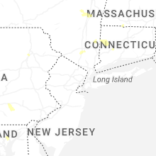
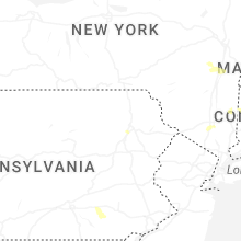
New York
| Local Time | Report Details |
|---|---|
| 1:06 PM EDT | Tree and power lines down on blodgett hill road in the town of coeyman in albany county NY, 23.1 miles S of Schenectady, NY |
| 1:07 PM EDT | Tree down on house on morehouse road in the town of coeyman in albany county NY, 21.7 miles S of Schenectady, NY |
| 1:08 PM EDT | Several trees and wires down with wires on a car near route 143 and waterboard road near coeymans hollo in albany county NY, 23 miles S of Schenectady, NY |
| 1:30 PM EDT | Report of trees and wires along route 81 in the town of greenville. time estimated from rada in greene county NY, 27.4 miles S of Schenectady, NY |
| 1:32 PM EDT | Large tree down on harpersfield rd west of jefferson leading to road closure. time estimated from rada in schoharie county NY, 41.9 miles WSW of Schenectady, NY |
| 2:00 PM EDT | Report of trees and wires down in town of durham. time estimated from rada in greene county NY, 30.8 miles SSW of Schenectady, NY |
| 2:18 PM EDT | Report of trees down in the vicinity of the lake george escape campgroun in warren county NY, 48.4 miles NNE of Schenectady, NY |
| 7:06 PM EDT | Utility company states many weather related power outages across brooklyn... with 5000+ without power near midwoo in kings county NY, 4.5 miles SE of Brooklyn, NY |
| 7:08 PM EDT | Downed wires on avenue in kings county NY, 5.4 miles SE of Brooklyn, NY |
Connecticut
| Local Time | Report Details |
|---|---|
| 3:00 PM EDT | A trained spotter reported a downed tree and powerline wires on main st in the town of broad brook. relayed by amateur radi in hartford county CT, 59.1 miles W of Providence, RI |
| 3:00 PM EDT | Dot reports tree down on rt 188 at wheeler road. also a few public reports of downed trees around the tow in new haven county CT, 73.8 miles NE of Brooklyn, NY |
| 3:15 PM EDT | Two tree limbs about 4 inches in diameter were downed in the area of ellington rd. relayed by amateur radi in hartford county CT, 59.3 miles W of Providence, RI |
| 4:40 PM EDT | Wires down causing a brush fire on cornwall bridge roa in litchfield county CT, 71.8 miles SSE of Schenectady, NY |
Vermont
| Local Time | Report Details |
|---|---|
| 3:08 PM EDT | Tree and wires down north road at bacon hollow roa in bennington county VT, 46.3 miles ENE of Schenectady, NY |
| 3:08 PM EDT | Tree and wires down on sunderland hill road near the elementary school. time estimated from rada in bennington county VT, 45.1 miles ENE of Schenectady, NY |
Idaho
| Local Time | Report Details |
|---|---|
| 1:30 PM MDT | Mesonet station itde2 d5 geneva summit us-8 in bear lake county ID, 92.3 miles SSE of Idaho Falls, ID |
| 5:30 PM MDT | Mesonet station grei 1 nw nite in caribou county ID, 68.8 miles SSE of Idaho Falls, ID |
| 5:40 PM MDT | Mesonet station pc119 soda spring eas in caribou county ID, 63.4 miles SSE of Idaho Falls, ID |
West Virginia
| Local Time | Report Details |
|---|---|
| 3:36 PM EDT | Quarter sized hail reported near Mineral Wells, WV, 59.5 miles N of Charleston, WV, pictures provided. |
Wyoming
| Local Time | Report Details |
|---|---|
| 1:40 PM MDT | Time estimated from radar in campbell county WY, 20.6 miles NW of Gillette, WY |
| 2:09 PM MDT | Storm damage reported in campbell county WY, 3.7 miles NNW of Gillette, WY |
| 2:10 PM MDT | Time estimated based on radar in campbell county WY, 20.6 miles NW of Gillette, WY |
| 2:20 PM MDT | Wydot senso in natrona county WY, 40.2 miles N of Casper, WY |
| 2:20 PM MDT | Midwest... wy pacificorp sit in natrona county WY, 41.4 miles N of Casper, WY |
| 2:20 PM MDT | Tisdale mountain... wy pacificorp sit in johnson county WY, 45.1 miles NNW of Casper, WY |
| 2:32 PM MDT | Storm damage reported in campbell county WY, 25.2 miles S of Gillette, WY |
| 3:00 PM MDT | Power lines down in pine haven. blowing dust on i90 causing low visibilit in crook county WY, 34.7 miles E of Gillette, WY |
| 3:24 PM MDT | Tree limbs down in tow in crook county WY, 56.2 miles E of Gillette, WY |
| 3:26 PM MDT | Storm damage reported in crook county WY, 53.8 miles W of Rapid City, SD |
| 3:26 PM MDT | Storm damage reported in crook county WY, 50.3 miles NE of Gillette, WY |
| 3:28 PM MDT | Asos station krks rock springs airpor in sweetwater county WY, 8 miles E of Rock Springs, WY |
| 3:36 PM MDT | Storm damage reported in weston county WY, 45.2 miles W of Rapid City, SD |
| 3:42 PM MDT | Storm damage reported in weston county WY, 45.2 miles W of Rapid City, SD |
| 3:45 PM MDT | Storm damage reported in weston county WY, 58.7 miles WSW of Rapid City, SD |
| 3:46 PM MDT | Storm damage reported in crook county WY, 52.7 miles NW of Rapid City, SD |
| 5:50 PM MDT | Mesonet station pc452 cottonwood mern in sublette county WY, 98 miles W of Riverton, WY |
| 6:32 PM MDT | Corrects previous non-tstm wnd gst report from 2 se hiland. mesonet station khld hiland 2.4 se (wydot in natrona county WY, 52.9 miles WNW of Casper, WY |
| 7:36 PM MDT | Mesonet station wy45 natrona (wydot in natrona county WY, 27 miles WNW of Casper, WY |
Massachusetts
| Local Time | Report Details |
|---|---|
| 4:00 PM EDT | Law enforcement reported a tree downed on wires on burt hill rd in tolland. relayed by amateur radi in hampden county MA, 69.4 miles SE of Schenectady, NY |
| 4:55 PM EDT | Large downed tree blocking part of sartelle st in pepperell. relayed by amateur radi in middlesex county MA, 59.2 miles N of Providence, RI |
| 4:55 PM EDT | Trees downed on sheffield st in pepperell. relayed by amateur radi in middlesex county MA, 59.3 miles N of Providence, RI |
| 4:55 PM EDT | Tree and powerline wires downed from thunderstorm winds caused closure of prescott st in pepperell. relayed by amateur radi in middlesex county MA, 60.5 miles N of Providence, RI |
| 5:00 PM EDT | In southwick... there were several large trees downe in hampden county MA, 74.1 miles WNW of Providence, RI |
| 5:15 PM EDT | Downed powerlines near 1070 main st in dunstable. relayed by amateur radi in middlesex county MA, 60 miles N of Providence, RI |
| 7:50 PM EDT | Corrects previous tstm wnd dmg report from 2 nne hamilton. two trees downed on county rd near ipswich. relayed by amateur radi in essex county MA, 63.7 miles NNE of Providence, RI |
Maine
| Local Time | Report Details |
|---|---|
| 4:12 PM EDT | A small cluster of big trees snapped at the edge of a farmers field. time estimated by rada in aroostook county ME, 23.7 miles WSW of Caribou, ME |
| 4:45 PM EDT | Report from social media. tree down near madawaska lake shoreline. large tree limb down as well. time estimated based on rada in aroostook county ME, 15.1 miles NW of Caribou, ME |
| 5:09 PM EDT | Report on social media of trees uprooted and others snapped in half. time estimated based on rada in aroostook county ME, 27.8 miles N of Caribou, ME |
New Hampshire
| Local Time | Report Details |
|---|---|
| 4:44 PM EDT | Wires dow in hillsborough county NH, 63.8 miles NNW of Providence, RI |
| 4:44 PM EDT | Tree down on lawrence lane near junction of worcester roa in hillsborough county NH, 62.1 miles N of Providence, RI |
| 5:00 PM EDT | Tree down blocking pepperell roa in hillsborough county NH, 62.9 miles N of Providence, RI |
| 5:00 PM EDT | Tree and wires down blocking west hollis r in hillsborough county NH, 62.2 miles N of Providence, RI |
| 5:08 PM EDT | Quarter sized hail reported near Amherst, NH, 73.4 miles N of Providence, RI, hail fell for 5 to 6 minutes and gusty winds knocked down some large branches. time estimated by radar. |
| 5:10 PM EDT | Tree down on hunt stree in hillsborough county NH, 64 miles N of Providence, RI |
| 5:10 PM EDT | Tree down on ash stree in hillsborough county NH, 64.7 miles N of Providence, RI |
| 5:10 PM EDT | Tree down on highland stree in hillsborough county NH, 65.3 miles N of Providence, RI |
| 5:25 PM EDT | Tree down on wires and second tree down on car on carter roa in hillsborough county NH, 74 miles N of Providence, RI |
| 5:30 PM EDT | Large tree down on top of crushed ca in hillsborough county NH, 81.2 miles WSW of Portland, ME |
| 5:38 PM EDT | Reports of numerous trees down north of town. two trees partially blocking traffic on n. main s in hillsborough county NH, 76.2 miles N of Providence, RI |
| 5:45 PM EDT | Large tree destroyed a garage on tinker rd before the fe everett parkway overpas in hillsborough county NH, 66.8 miles N of Providence, RI |
| 5:55 PM EDT | Half Dollar sized hail reported near Swanzey, NH, 84.1 miles NNW of Providence, RI, observed hail on rt. 12 and lasted 7 to 8 minutes. kestrel measured wind gust to 41 mph. |
| 6:05 PM EDT | Emergency dispatch reported trees on wires along jaffrey rd (nh hwy 124) and a large tree on blocking a lane of travel (unknown which lane) on jaffrey rd west of shaker in cheshire county NH, 80.3 miles NNW of Providence, RI |
| 6:18 PM EDT | Corrects the time of previous tstm wnd dmg report from jaffrey. observed at least 12 trees and numerous branches down across jaffrey following a severe stor in cheshire county NH, 74.8 miles NNW of Providence, RI |
| 6:38 PM EDT | Observed at least 12 trees and numerous branches down across jaffrey following a severe stor in cheshire county NH, 74.8 miles NNW of Providence, RI |
| 7:40 PM EDT | Quarter sized hail reported near Hollis, NH, 63.8 miles N of Providence, RI, reported by amateur radio. |
Virginia
| Local Time | Report Details |
|---|---|
| 5:00 PM EDT | Three calls for trees and wires down on the northern and northeastern side of charlottesvill in albemarle county VA, 58.6 miles NW of Richmond, VA |
New Jersey
| Local Time | Report Details |
|---|---|
| 5:02 PM EDT | Trees and wires reported down across lebanon twp. time estimate in hunterdon county NJ, 47.3 miles W of Brooklyn, NY |
| 5:16 PM EDT | Trees and wires reported down across raritan twp. time estimate in hunterdon county NJ, 48.1 miles WSW of Brooklyn, NY |
| 5:16 PM EDT | Trees and wires reported down across delaware twp. time estimate in hunterdon county NJ, 52.7 miles WSW of Brooklyn, NY |
| 5:34 PM EDT | Trees down in branchburg twp blocking a roadway. time estimate in somerset county NJ, 38.4 miles WSW of Brooklyn, NY |
| 5:43 PM EDT | Trees down in bedminster twp blocking a roadway. time estimate in somerset county NJ, 34.7 miles W of Brooklyn, NY |
| 5:46 PM EDT | Multiple trees and wires down. time estimated from rada in somerset county NJ, 38.7 miles WSW of Brooklyn, NY |
| 6:35 PM EDT | Asos station kewr newark airpor in union county NJ, 9.5 miles W of Brooklyn, NY |
| 6:58 PM EDT | Downed wires on nj 3 eastbound at east of harmon cove in secaucu in hudson county NJ, 7.7 miles NNW of Brooklyn, NY |
Florida
| Local Time | Report Details |
|---|---|
| 5:15 PM EDT | Clay county fire dispatch called the nws jax office to report that a large tree was down on idlewild ave near sunset ave. time estimated based on rada in clay county FL, 24.3 miles S of Jacksonville, FL |
| 5:20 PM EDT | Several downed trees and powerlines in the vicinity of old kings rd and san clerc rd. several unanchored storage shed were overturned and fencing damaged along old king in duval county FL, 7.7 miles SSE of Jacksonville, FL |
| 5:38 PM EDT | Delayed report from 911 dispatch. tree down on powerline at clara road in the southside area. time based on radar velocit in duval county FL, 5.7 miles SE of Jacksonville, FL |
| 5:39 PM EDT | Delayed report from 911 dispatch. tree down on powerlines at 7461 phillips highway. time estimated by radar velocit in duval county FL, 7.4 miles SSE of Jacksonville, FL |
| 5:42 PM EDT | Delayed report from 911 dispatch. tree down on powerlines at 7171 arlington expressway. time estimated by radar velocit in duval county FL, 4.5 miles E of Jacksonville, FL |
| 5:42 PM EDT | Delayed report. 911 dispatch relayed tree down on power line at north arlington road and arlington expressway. time estimated by radar velocit in duval county FL, 3.9 miles E of Jacksonville, FL |
South Carolina
| Local Time | Report Details |
|---|---|
| 5:45 PM EDT | Emergency manager reported one tree down blocking one lane on hendersonville highwa in colleton county SC, 46.4 miles NNE of Savannah, GA |
| 6:15 PM EDT | Emergency manager reported one tree down blocking both lanes on pon pon plantation ave near charleston highwa in colleton county SC, 39.6 miles SW of Charleston, SC |
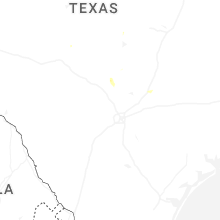
Nebraska
| Local Time | Report Details |
|---|---|
| 5:57 PM MDT | Time estimated by radar. public report of wind with half inch diameter hai in sheridan county NE, 83.5 miles SSE of Rapid City, SD |
| 6:38 PM MDT | Half Dollar sized hail reported near Hay Springs, NE, 80.5 miles NE of Scottsbluff, NE |
| 7:42 PM MDT | Golf Ball sized hail reported near Lakeside, NE, 78 miles ENE of Scottsbluff, NE |
| 10:54 PM CDT | At home weather station had a 65 mph wind gus in holt county NE, 32.2 miles NNW of Oneill, NE |
North Dakota
| Local Time | Report Details |
|---|---|
| 6:11 PM MDT | Storm damage reported in harding county SD, 123.4 miles N of Rapid City, SD |
| 6:21 PM MDT | Storm damage reported in harding county SD, 123.4 miles N of Rapid City, SD |
Nevada
| Local Time | Report Details |
|---|---|
| 5:11 PM PDT | Station id: d6485 (cwop) name: dw6485 elko elevation: 5230 fee in elko county NV, 12.7 miles NE of Elko, NV |
Connect with Interactive Hail Maps