

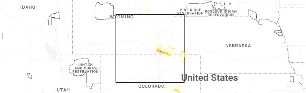
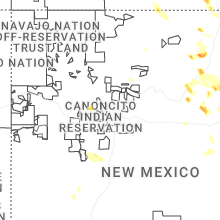
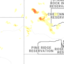
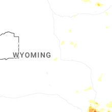
Hail Map for Friday, August 1, 2025
Number of Impacted Households on 8/1/2025
0
Impacted by 1" or Larger Hail
0
Impacted by 1.75" or Larger Hail
0
Impacted by 2.5" or Larger Hail
Square Miles of Populated Area Impacted on 8/1/2025
0
Impacted by 1" or Larger Hail
0
Impacted by 1.75" or Larger Hail
0
Impacted by 2.5" or Larger Hail

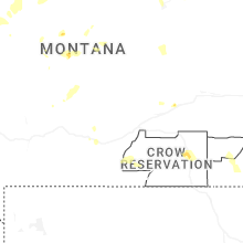
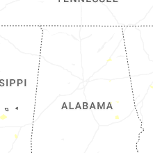
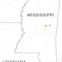
Cities Most Affected by Hail Storms of 8/1/2025
| Hail Size | Demographics of Zip Codes Affected | ||||||
|---|---|---|---|---|---|---|---|
| City | Count | Average | Largest | Pop Density | House Value | Income | Age |
| Cheyenne, WY | 5 | 2.20 | 2.75 | 370 | $93k | $34.3k | 33.6 |
| Carpenter, WY | 1 | 3.00 | 3.00 | 4 | $103k | $33.8k | 39.2 |
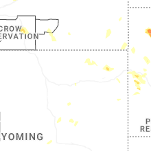
| Buffalo, MT | 1 | 2.00 | 2.00 | 1 | $0k | $0.0k | 45.2 |
| Newell, SD | 1 | 1.75 | 1.75 | 1 | $38k | $25.9k | 47.2 |
| Buffalo, SD | 1 | 1.75 | 1.75 | 0 | $50k | $25.3k | 43.2 |
| Mud Butte, SD | 1 | 1.75 | 1.75 | 0 | $45k | $30.2k | 41.0 |
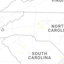
Hail and Wind Damage Spotted on 8/1/2025
Filter by Report Type:Hail ReportsWind Reports
States Impacted
North Carolina, Virginia, South Carolina, Wyoming, Georgia, South Dakota, Texas, Colorado, Montana, New MexicoNorth Carolina
| Local Time | Report Details |
|---|---|
| 1:14 PM EDT | Tree down along ramey creek roa in surry county NC, 74.3 miles E of Bristol, TN |
| 1:51 PM EDT | Tree down on ramp of i-74 near w pine stree in surry county NC, 69.4 miles SW of Roanoke, VA |
| 2:58 PM EDT | Thunderstorm winds blew down one tree near the 2400 block of rockford roa in yadkin county NC, 67.5 miles N of Charlotte, NC |
| 2:58 PM EDT | Thunderstorm winds blew down one tree near the 2400 block of rockford roa in yadkin county NC, 66.8 miles N of Charlotte, NC |
| 3:22 PM EDT | Trees on utility equipmen in cleveland county NC, 47.3 miles WNW of Charlotte, NC |
| 3:44 PM EDT | Thunderstorm winds blew down a power line along the 3200 block of blankenship roa in yadkin county NC, 61.3 miles N of Charlotte, NC |
| 3:47 PM EDT | Trees and power lines dow in forsyth county NC, 69.4 miles NNE of Charlotte, NC |
| 3:55 PM EDT | Tree down along us 421 near mile marker 24 in forsyth county NC, 64.1 miles NNE of Charlotte, NC |
| 4:00 PM EDT | Tree and/or utility line damage causing power outage along underpass r in davie county NC, 57.3 miles NNE of Charlotte, NC |
| 4:12 PM EDT | Numerous trees down on the west side of statesville north of the airport and along/south of i-4 in iredell county NC, 38.2 miles N of Charlotte, NC |
| 4:15 PM EDT | Tree down on hepler dr. time estimate in davie county NC, 53 miles NNE of Charlotte, NC |
| 4:18 PM EDT | Tree down on hillcrest dr. time estimate in davie county NC, 56.6 miles NNE of Charlotte, NC |
| 4:20 PM EDT | Emergency manager reports numerous downed trees and power line across the city and county... in addition to a tree down on a mobile hom in forsyth county NC, 68.7 miles NNE of Charlotte, NC |
| 4:30 PM EDT | 1501 lentz harness shop rd. trees blocking the road. time estimated from rada in cabarrus county NC, 28.1 miles ENE of Charlotte, NC |
| 4:30 PM EDT | Several trees down on powerlines and utility equipment in troutma in iredell county NC, 33.1 miles N of Charlotte, NC |
| 4:36 PM EDT | Multiple power outages reported in pleasant grove due to trees down on powerlines and transformers near jeffries cross r in alamance county NC, 48 miles NW of Raleigh, NC |
| 4:40 PM EDT | Tree downed along otis dellinger r in lincoln county NC, 26.7 miles NW of Charlotte, NC |
| 4:53 PM EDT | Several trees down on powerlines and utility equipment across the north side of gastoni in gaston county NC, 17.2 miles WNW of Charlotte, NC |
| 4:54 PM EDT | Trees down at blackwelder farm dr and shearers r in iredell county NC, 22.6 miles N of Charlotte, NC |
| 4:55 PM EDT | Cranford road blocked by downed tree in rowan county NC, 42 miles NE of Charlotte, NC |
| 5:00 PM EDT | Trees downed off of presbyterian rd. time estimated from rada in iredell county NC, 20.6 miles N of Charlotte, NC |
| 5:02 PM EDT | Fallen tree damaged utility equipmen in cabarrus county NC, 20.5 miles NE of Charlotte, NC |
| 5:04 PM EDT | Tree on a house off of long ferry r in rowan county NC, 40.9 miles NE of Charlotte, NC |
| 5:05 PM EDT | Trees down on utility equipmen in rowan county NC, 38.3 miles NE of Charlotte, NC |
| 5:06 PM EDT | Trees down on power equipment along carr store rd and hwy 8 in orange county NC, 38.5 miles NW of Raleigh, NC |
| 5:23 PM EDT | Tree down on utility equipmen in mecklenburg county NC, 8.4 miles ENE of Charlotte, NC |
| 5:25 PM EDT | A large number of mature... old trees fell on homes near st matthews church rd and lakeshore dr along south shore of high rock lake. no injuries but several homes appea in rowan county NC, 39.1 miles NE of Charlotte, NC |
| 5:26 PM EDT | Tree down on utility equipmen in mecklenburg county NC, 9.7 miles N of Charlotte, NC |
| 5:27 PM EDT | Social media report of stop lights blown off lines along south boulevard just north of i-48 in mecklenburg county NC, 6.8 miles SSW of Charlotte, NC |
| 5:28 PM EDT | Tree down blocking road on thayer rd & cashatt rd in southern trinit in randolph county NC, 61.8 miles NE of Charlotte, NC |
| 5:30 PM EDT | Corrects previous tstm wnd dmg report from 3 e mount pleasant. 1501 lentz harness shop rd. trees blocking the road. time estimated from rada in cabarrus county NC, 28.1 miles ENE of Charlotte, NC |
| 5:37 PM EDT | Social media picture of a tree down on a car near selwyn av in mecklenburg county NC, 2.9 miles S of Charlotte, NC |
| 5:58 PM EDT | Tree down across the roa in randolph county NC, 62.3 miles ENE of Charlotte, NC |
| 6:03 PM EDT | Social media picture of a tree down between mineral springs and wesley chape in union county NC, 20.1 miles SSE of Charlotte, NC |
| 6:30 PM EDT | Trees down on ebenezer church rd on power equipmen in wake county NC, 5.7 miles NW of Raleigh, NC |
| 7:12 PM EDT | Fallen trees and power line in johnston county NC, 13.1 miles SSE of Raleigh, NC |
| 8:00 PM EDT | Thunderstorm damag in moore county NC, 67.3 miles SW of Raleigh, NC |
Virginia
| Local Time | Report Details |
|---|---|
| 1:21 PM EDT | Tree down near intersection of rock ridge and ferrum mountain roa in franklin county VA, 21.7 miles SSW of Roanoke, VA |
| 2:23 PM EDT | Multiple trees down off oak level roa in henry county VA, 34.6 miles S of Roanoke, VA |
| 2:23 PM EDT | Tree down near intersection of oak level road and oakhaven driv in henry county VA, 34.6 miles S of Roanoke, VA |
| 2:26 PM EDT | Thunderstorm winds blew down one tree along the 3600 block of spencer-preston roa in henry county VA, 41.6 miles S of Roanoke, VA |
| 2:30 PM EDT | Thunderstorm winds blew down one tree along the 3200 block of stillmeadow roa in pittsylvania county VA, 39.4 miles SSE of Roanoke, VA |
| 6:38 PM UTC | Tree down across sago roa in pittsylvania county VA, 37 miles SSE of Roanoke, VA |
| 2:39 PM EDT | Tree down on power lines blocking both lanes along stultz roa in henry county VA, 39.5 miles S of Roanoke, VA |
| 2:56 PM EDT | Tree down blocking both lanes of vista view lan in henry county VA, 47.9 miles S of Roanoke, VA |
| 2:58 PM EDT | Tree down blocking one lane of old liberty driv in henry county VA, 43.1 miles SSE of Roanoke, VA |
| 3:09 PM EDT | Thunderstorm winds blew down one tree near the 1200 block of sandy creek roa in pittsylvania county VA, 49 miles SSE of Roanoke, VA |
South Carolina
| Local Time | Report Details |
|---|---|
| 3:29 PM EDT | Three power poles broken at flo airport due to the wind gust in florence county SC, 69.7 miles NNE of Charleston, SC |
| 4:40 PM EDT | Tree reported down on a house along hampton av in cherokee county SC, 47.6 miles WSW of Charlotte, NC |
| 5:00 PM EDT | Multiple trees down on lawrence rd. time estimate in york county SC, 25.3 miles WSW of Charlotte, NC |
| 5:17 PM EDT | Tree down on richbourg rd. time estimate in greenville county SC, 15.2 miles ENE of Greenville, SC |
| 5:18 PM EDT | Tree on utility equipment on lake fairfield d in greenville county SC, 14.6 miles ENE of Greenville, SC |
| 5:50 PM EDT | Storm damage reported in horry county SC, 68.2 miles SW of Wilmington, NC |
| 6:40 PM EDT | Lancaster county dispatch reported a tree down on power lines on great falls hwy at douglas rd. time estimated by rada in lancaster county SC, 38.8 miles S of Charlotte, NC |
| 7:35 PM EDT | Scdps reported a tree in the roadway on hollingshed rd. time estimated by rada in richland county SC, 64.9 miles NE of Augusta, GA |
| 7:37 PM EDT | Lexington county dispatch reported power lines down along bush river rd at spartan d in lexington county SC, 61.2 miles NE of Augusta, GA |
| 7:50 PM EDT | Sc highway patrol reported trees down on bruce r in lexington county SC, 62.5 miles NE of Augusta, GA |
| 7:52 PM EDT | Scdps reported multiple trees down on i-26 near augusta rd. time estimated by rada in lexington county SC, 60.6 miles NE of Augusta, GA |
| 7:55 PM EDT | Saluda county dispatch reported a tree on the roadway on john rushton rd. time estimated by rada in saluda county SC, 41.1 miles NNE of Augusta, GA |
| 8:25 PM EDT | Newberry county dispatch reported multiple trees down on state park rd at state park loop rd. time estimated by rada in newberry county SC, 53.2 miles NE of Augusta, GA |
| 9:46 PM EDT | Schp reported a tree down on wesley chapel av in colleton county SC, 34 miles WSW of Charleston, SC |
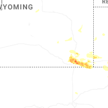
Wyoming
| Local Time | Report Details |
|---|---|
| 2:08 PM MDT | Asos station kriw riverton airport. downdraft from weak convectio in fremont county WY, 5.5 miles NW of Riverton, WY |
| 3:04 PM MDT | Asos station kgey greybull airport. from a strong outflow boundar in big horn county WY, 89.7 miles SSE of Billings, MT |
| 5:18 PM MDT | Half Dollar sized hail reported near Cheyenne, WY, 25.5 miles E of Laramie, WY |
| 5:19 PM MDT | Storm damage reported in laramie county WY, 26.4 miles E of Laramie, WY |
| 5:30 PM MDT | Half Dollar sized hail reported near Cheyenne, WY, 30.7 miles ESE of Laramie, WY |
| 5:52 PM MDT | Ping Pong Ball sized hail reported near Cheyenne, WY, 42 miles ESE of Laramie, WY, report from mping: ping pong ball (1.50 in.). |
| 5:55 PM MDT | Ping Pong Ball sized hail reported near Cheyenne, WY, 40.6 miles ESE of Laramie, WY, report from mping: ping pong ball (1.50 in.). |
| 5:55 PM MDT | Hen Egg sized hail reported near Cheyenne, WY, 42 miles ESE of Laramie, WY, report from mping: hen egg (2.00 in.). |
| 5:56 PM MDT | Golf Ball sized hail reported near Cheyenne, WY, 41.1 miles ESE of Laramie, WY |
| 5:58 PM MDT | Ping Pong Ball sized hail reported near Cheyenne, WY, 42 miles ESE of Laramie, WY, report from mping: ping pong ball (1.50 in.). |
| 5:59 PM MDT | Baseball sized hail reported near Cheyenne, WY, 43.3 miles ESE of Laramie, WY |
| 6:03 PM MDT | Ping Pong Ball sized hail reported near Cheyenne, WY, 44.1 miles ESE of Laramie, WY, report from mping: ping pong ball (1.50 in.). |
| 6:12 PM MDT | Hen Egg sized hail reported near Cheyenne, WY, 44.9 miles ESE of Laramie, WY, report from mping: hen egg (2.00 in.). |
| 6:12 PM MDT | Tennis Ball sized hail reported near Cheyenne, WY, 43.8 miles ESE of Laramie, WY, report from mping: tennis ball (2.50 in.). |
| 7:04 PM MDT | Tea Cup sized hail reported near Carpenter, WY, 63 miles ESE of Laramie, WY, trained spotter reported hail sized up to 3 inches via sm with picture evidence. |
| 8:48 PM MDT | Ping Pong Ball sized hail reported near Devils Tower, WY, 44.3 miles ENE of Gillette, WY |
Georgia
| Local Time | Report Details |
|---|---|
| 4:30 PM EDT | One tree down along highway 17 near the city limits of richmond hill... g in bryan county GA, 17.5 miles SW of Savannah, GA |
| 4:39 PM EDT | Broadcast media shared viewer photos from the piercefield neighborhood of richmond hill... ga. photos showed numerous large tree branches down. one flag pole was blown in bryan county GA, 17.5 miles SW of Savannah, GA |
| 4:40 PM EDT | Social media picture of the top of a large oak tree snapped off. the damage was in the backyard of a home along harris trail roa in bryan county GA, 17 miles SW of Savannah, GA |
| 4:53 PM EDT | A tree and power line were down along sustella av in lowndes county GA, 52.8 miles SSW of Douglas, GA |
| 4:54 PM EDT | A tree resulted in a power outage along terrace blvd via the georgia power outage ma in lowndes county GA, 51.9 miles SSW of Douglas, GA |
| 7:59 PM EDT | A tree reported down on one lane of old poor robin road near the intersection with newington highwa in screven county GA, 49.2 miles NNW of Savannah, GA |
| 12:02 AM EDT | The tybee south weatherflow observed a 52 kt wind gus in chatham county GA, 15.5 miles ESE of Savannah, GA |
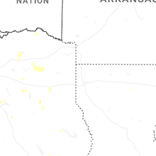
South Dakota
| Local Time | Report Details |
|---|---|
| 3:05 PM MDT | Golf Ball sized hail reported near Buffalo, SD, 86.4 miles N of Rapid City, SD |
| 3:38 PM MDT | Golf Ball sized hail reported near Newell, SD, 82.1 miles N of Rapid City, SD |
| 5:49 PM MDT | Quarter sized hail reported near Faith, SD, 81.2 miles NNE of Rapid City, SD, marble to quarter size hail. |
| 6:05 PM MDT | Golf Ball sized hail reported near Mud Butte, SD, 63.1 miles NNE of Rapid City, SD |
| 6:10 PM MDT | Storm damage reported in meade county SD, 62.6 miles NNE of Rapid City, SD |
| 7:25 PM MDT | Quarter sized hail reported near Lead, SD, 31.9 miles WNW of Rapid City, SD |
Texas
| Local Time | Report Details |
|---|---|
| 4:25 PM CDT | Facebook photo showed a tree and power line down in killee in bell county TX, 1.2 miles SSE of Killeen, TX |
| 4:27 PM CDT | Corrects previous tstm wnd dmg report from 3 n killeen. khlr measured a wind gust of 67 mph / 58 knots out of the s in bell county TX, 1.9 miles NNE of Killeen, TX |
| 4:40 PM CDT | Corrects previous tstm wnd dmg report from 3 n killeen. khlr measured a second peak wind gust of 59 mph / 51 knots out of the wn in bell county TX, 1.9 miles NNE of Killeen, TX |
| 4:50 PM CDT | Facebook report of several large tree branches down near the baylor hospital on s 31st st in templ in bell county TX, 22.5 miles E of Killeen, TX |
| 4:50 PM CDT | Facebook report of tree down on s 31st st in templ in bell county TX, 21.9 miles E of Killeen, TX |
| 5:05 PM CDT | Corrects previous tstm wnd dmg report from 2 ne temple. photo on x of a large tree branch snapped in north templ in bell county TX, 23.5 miles E of Killeen, TX |
| 5:05 PM CDT | Photo on x of a large tree branch snapped in north templ in bell county TX, 22.9 miles E of Killeen, TX |
| 5:50 PM CDT | Power lines and trees down on lydia lan in williamson county TX, 44.3 miles SE of Killeen, TX |
| 6:06 PM CDT | Local police report of trees down in pritchet in upshur county TX, 74.9 miles W of Shreveport, LA |
| 6:32 PM CDT | Tree down at fm 1647 near fm 85 in wood county TX, 86.1 miles WNW of Shreveport, LA |
| 7:33 PM CDT | Report of a tree down on fm 3135 on the east side of henderso in rusk county TX, 56.4 miles N of Lufkin, TX |
| 7:33 PM CDT | Report of a tree down on cr 10 in rusk county TX, 61.7 miles N of Lufkin, TX |
| 7:40 PM CDT | Power lines down cr 4115 and cr 411 in rusk county TX, 57.6 miles NNW of Lufkin, TX |
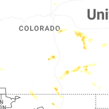
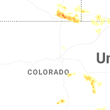
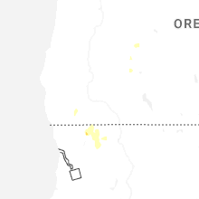
Colorado
| Local Time | Report Details |
|---|---|
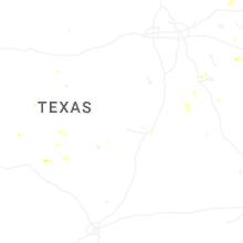
| 4:47 PM MDT | Quarter sized hail reported near Fort Lupton, CO, 25.2 miles NNE of Denver, CO, report from mping: quarter (1.00 in.). |
| 5:45 PM MDT | Storm damage reported in lincoln county CO, 79.7 miles NE of Pueblo, CO |
| 5:54 PM MDT | Storm damage reported in lincoln county CO, 81.8 miles NE of Pueblo, CO |
| 6:56 PM MDT | Half Dollar sized hail reported near Grover, CO, 69.9 miles SSW of Scottsbluff, NE, report from mping: half dollar (1.25 in.). |
| 7:00 PM MDT | Upr site up695 in aroya measured a 58 mph wind gust at 7:00 pm mdt. temperature dropped from the 70s to the upper 50s... consistent with outflow... though.. wind direct in cheyenne county CO, 89.9 miles ENE of Pueblo, CO |
| 7:37 PM MDT | Storm damage reported in logan county CO, 64.3 miles SSE of Scottsbluff, NE |
| 7:40 PM MDT | Storm damage reported in logan county CO, 64.5 miles NNW of Yuma, CO |
| 7:45 PM MDT | Upr site ktcrsn in kit carson reported a 63 mph wind gust at 7:45 pm mdt. wind direction from the nn in cheyenne county CO, 93.8 miles S of Yuma, CO |
| 7:45 PM MDT | Mesonet station tt562 north sterlin in logan county CO, 54.3 miles NNW of Yuma, CO |
| 7:55 PM MDT | Awos station k1mw sterling 15 wn in logan county CO, 56.6 miles NW of Yuma, CO |
| 7:55 PM MDT | Awos station k1jw peet in logan county CO, 63.9 miles NNW of Yuma, CO |
| 7:56 PM MDT | Storm damage reported in logan county CO, 51.3 miles NNW of Yuma, CO |
| 8:04 PM MDT | Mesonet station co035 i-76 sterlin in logan county CO, 41.9 miles NW of Yuma, CO |
| 8:05 PM MDT | Storm damage reported in logan county CO, 54 miles NNW of Yuma, CO |
| 8:40 PM MDT | Storm damage reported in phillips county CO, 44.1 miles N of Yuma, CO |
| 8:45 PM MDT | Storm damage reported in logan county CO, 37.7 miles NNW of Yuma, CO |
| 8:48 PM MDT | Storm damage reported in phillips county CO, 35.5 miles NNE of Yuma, CO |
| 8:49 PM MDT | Storm damage reported in phillips county CO, 28 miles N of Yuma, CO |
| 8:50 PM MDT | Storm damage reported in phillips county CO, 31.5 miles NNE of Yuma, CO |
| 8:51 PM MDT | Home weather station measured a 59 mph wind gust at 8:51 pm md in yuma county CO, 20.5 miles NNE of Yuma, CO |
| 9:04 PM MDT | Weatherlink station wl-paoli3.34 in phillips county CO, 34.7 miles NNE of Yuma, CO |
| 9:09 PM MDT | Storm damage reported in phillips county CO, 38.6 miles NE of Yuma, CO |
| 9:11 PM MDT | Home weather station measured a 70 mph wind gust at 9:11 pm md in yuma county CO, 25.9 miles NE of Yuma, CO |
| 9:15 PM MDT | Awos station kheq holyoke airpor in phillips county CO, 39 miles NE of Yuma, CO |
| 9:15 PM MDT | Mesonet station co048 us 385 holyok in phillips county CO, 33 miles NE of Yuma, CO |
| 9:15 PM MDT | Mesonet station aw276 holyok in phillips county CO, 35.4 miles NE of Yuma, CO |
| 9:20 PM MDT | Storm damage reported in sedgwick county CO, 55 miles NNE of Yuma, CO |
| 9:26 PM MDT | Mesonet station co034 i-76 julesbur in sedgwick county CO, 63.8 miles NNE of Yuma, CO |
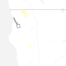
Montana
| Local Time | Report Details |
|---|---|
| 5:05 PM MDT | Hen Egg sized hail reported near Buffalo, MT, 84.2 miles SE of Great Falls, MT, two separate reports of golf ball to 2 inch hail in buffalo. |
| 5:21 PM MDT | Mesonet station sdam8 soda spring in yellowstone county MT, 6.3 miles SE of Billings, MT |
| 7:55 PM MDT | Mt mesonet station loma in chouteau county MT, 48.8 miles NE of Great Falls, MT |
| 9:30 PM MDT | Mesonet station mtmal 11.3 sw phillips (mt dot in phillips county MT, 75 miles ESE of Havre, MT |
New Mexico
| Local Time | Report Details |
|---|---|
| 9:00 PM MDT | Large tree blown over. time estimated from nearby airport observatio in guadalupe county NM, 56.6 miles WSW of Tucumcari, NM |
Connect with Interactive Hail Maps